


Imogen Piper
@imogenpiper.bsky.social
Visual Forensics Reporter, The Washington Post
Hi David, I'm a reporter from The Washington Post. Could you message me, we're interested in publishing your photo. Thanks!
September 16, 2025 at 4:26 PM
Hi David, I'm a reporter from The Washington Post. Could you message me, we're interested in publishing your photo. Thanks!
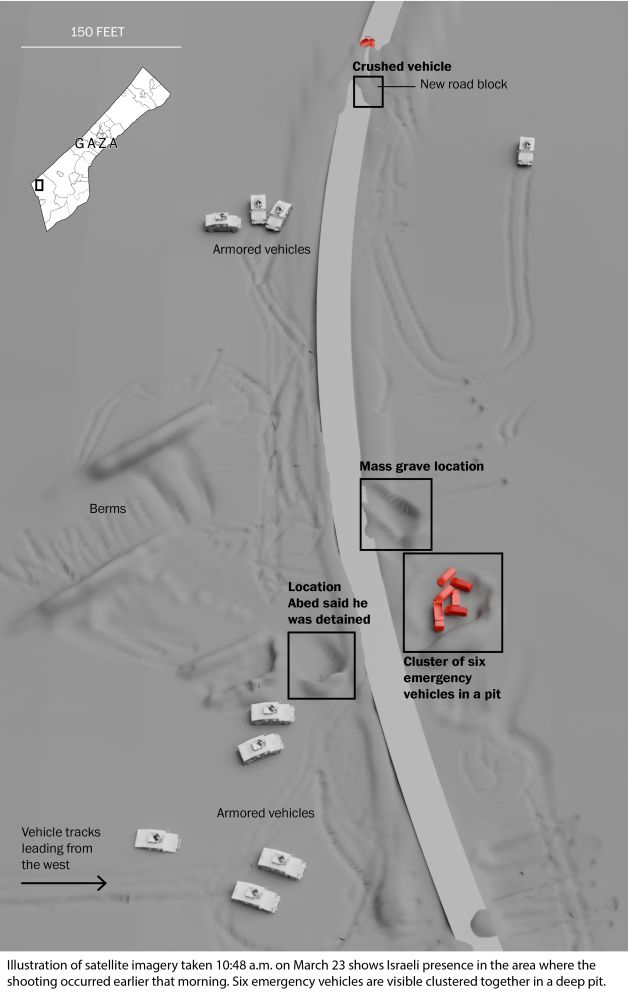
Unable to publish crucial satellite imagery evidence from the moments after the incident, we recreated the scene in 3D.
Six emergency vehicles are visible in a hole just south of where medics' bodies would be exhumed a week later.
20 IDF vehicles are within a 0.5mile radius.
Six emergency vehicles are visible in a hole just south of where medics' bodies would be exhumed a week later.
20 IDF vehicles are within a 0.5mile radius.
April 10, 2025 at 6:12 PM
Unable to publish crucial satellite imagery evidence from the moments after the incident, we recreated the scene in 3D.
Six emergency vehicles are visible in a hole just south of where medics' bodies would be exhumed a week later.
20 IDF vehicles are within a 0.5mile radius.
Six emergency vehicles are visible in a hole just south of where medics' bodies would be exhumed a week later.
20 IDF vehicles are within a 0.5mile radius.
While the Israeli military said the soldiers shot from afar, gunfire was initially 150 feet away or less when they opened fire on the convoy of emergency vehicles and later was within about 50 feet, according to the estimates of two audio forensics experts who analyzed audio for The Post.
April 10, 2025 at 5:59 PM
While the Israeli military said the soldiers shot from afar, gunfire was initially 150 feet away or less when they opened fire on the convoy of emergency vehicles and later was within about 50 feet, according to the estimates of two audio forensics experts who analyzed audio for The Post.
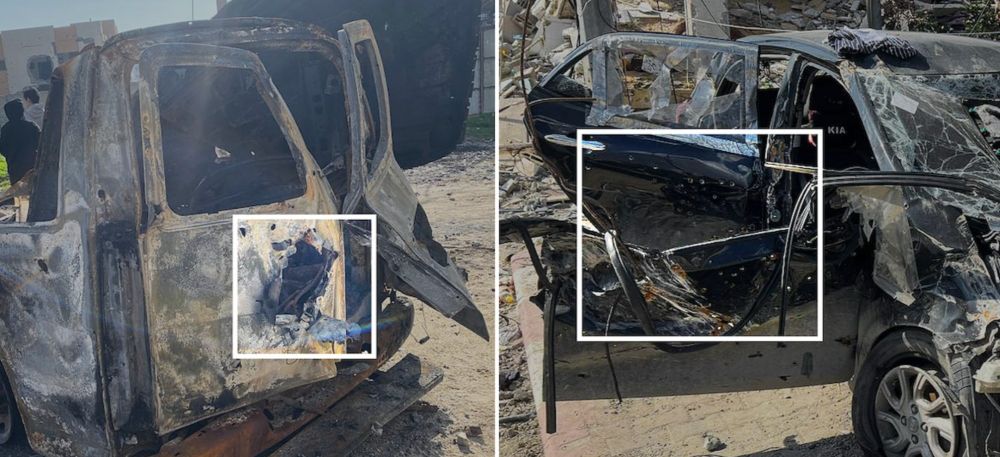
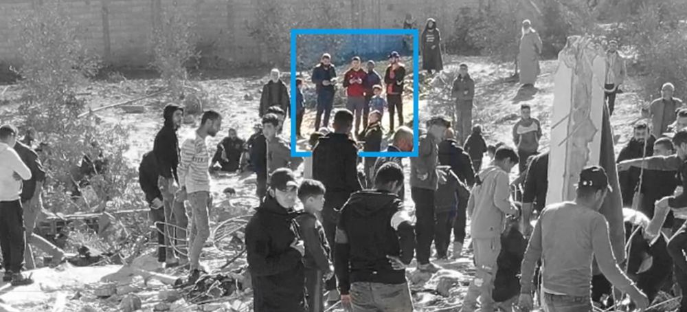
Palestinian paramedics said Israel gave them safe passage to save a 6-year-old girl in Gaza. They were all killed.
Gift link - t.co/m5uFT5qIqo
Gift link - t.co/m5uFT5qIqo
March 18, 2025 at 6:42 PM
Palestinian paramedics said Israel gave them safe passage to save a 6-year-old girl in Gaza. They were all killed.
Gift link - t.co/m5uFT5qIqo
Gift link - t.co/m5uFT5qIqo
Israel is demolishing northern Gaza and fortifying military positions, imagery shows
Gift link - t.co/8TsOCvDB1o
Gift link - t.co/8TsOCvDB1o
March 18, 2025 at 6:40 PM
Israel is demolishing northern Gaza and fortifying military positions, imagery shows
Gift link - t.co/8TsOCvDB1o
Gift link - t.co/8TsOCvDB1o
Threading some of the stories that won...
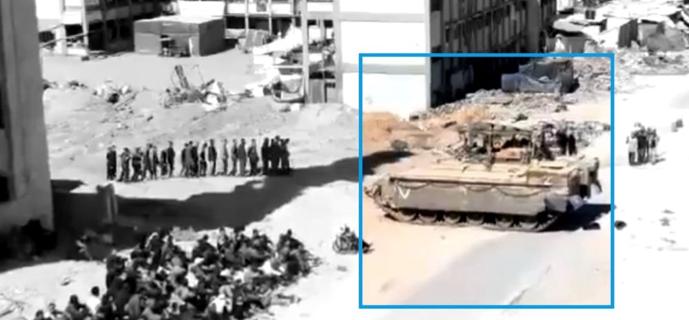
Drone footage raises questions about Israeli justification for deadly strike on Gaza journalists
Gift link - t.co/PYrw8C9H5u
Drone footage raises questions about Israeli justification for deadly strike on Gaza journalists
Gift link - t.co/PYrw8C9H5u
March 18, 2025 at 6:38 PM
Threading some of the stories that won...
Drone footage raises questions about Israeli justification for deadly strike on Gaza journalists
Gift link - t.co/PYrw8C9H5u
Drone footage raises questions about Israeli justification for deadly strike on Gaza journalists
Gift link - t.co/PYrw8C9H5u
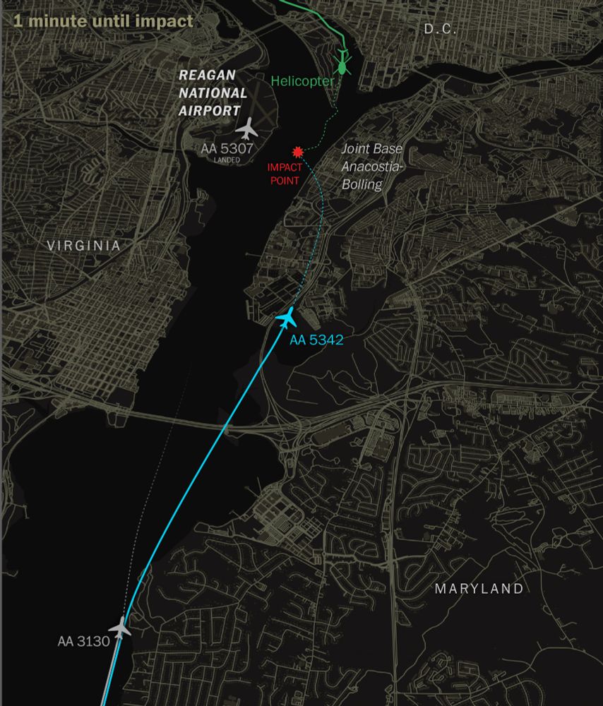
At this point if the helicopter pilot had misidentified the incoming plane for one further behind, it would have become increasingly difficult for them to realize their mistake as the AA 5342 jet's lights merged with the city lights below as it arced to the east preparing to land at runway 33.
February 14, 2025 at 1:06 PM
At this point if the helicopter pilot had misidentified the incoming plane for one further behind, it would have become increasingly difficult for them to realize their mistake as the AA 5342 jet's lights merged with the city lights below as it arced to the east preparing to land at runway 33.
Our examination shows how the American Airlines jet, AA5342, and the second plane AA3130, though separated by miles, would have appeared close to one another near the horizon and the helicopter crew could have confused the two jets when the tower first warned of incoming air traffic.
February 14, 2025 at 12:58 PM
Our examination shows how the American Airlines jet, AA5342, and the second plane AA3130, though separated by miles, would have appeared close to one another near the horizon and the helicopter crew could have confused the two jets when the tower first warned of incoming air traffic.
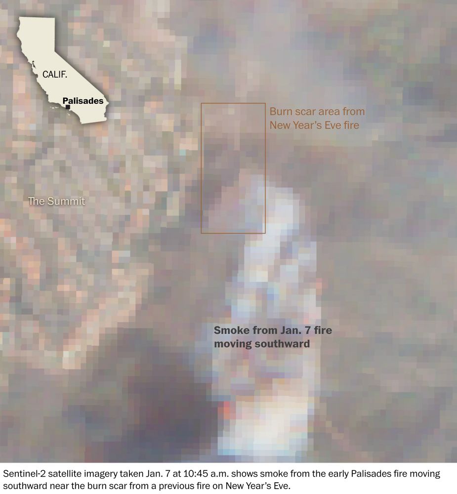
Sentinel-2 satellite imagery taken on Tuesday at 10:45 a.m., around 20 minutes after the Palisades Fire began, indicates that the origin of the smoke overlapped with the burn scar from the New Year’s Eve fire. Smoke extends in the direction of the wind, to the south.
January 12, 2025 at 7:49 PM
Sentinel-2 satellite imagery taken on Tuesday at 10:45 a.m., around 20 minutes after the Palisades Fire began, indicates that the origin of the smoke overlapped with the burn scar from the New Year’s Eve fire. Smoke extends in the direction of the wind, to the south.
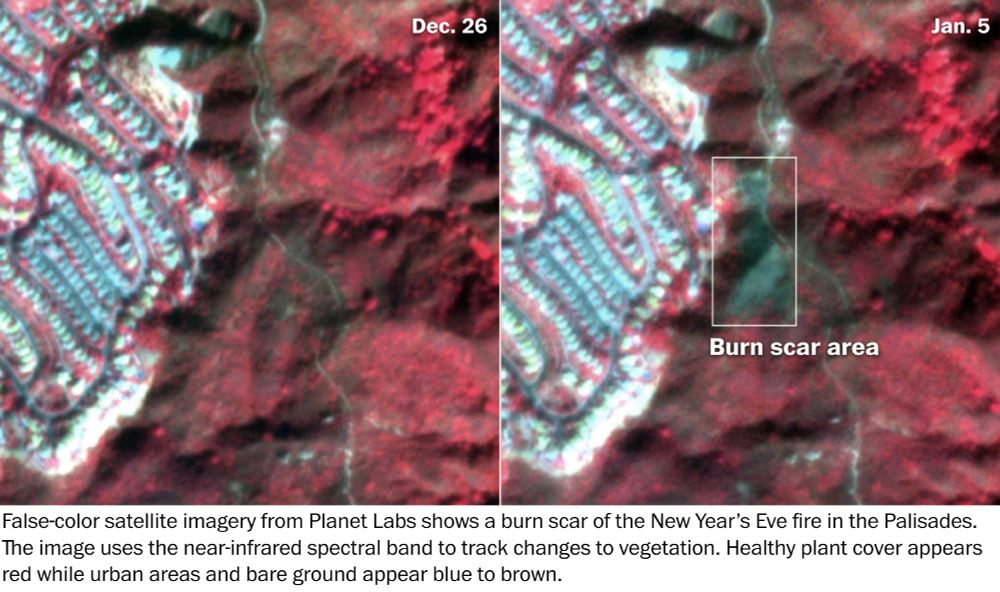
The Post identified the burn scar of the New Year’s Eve fire using false-color satellite imagery taken before and after the blaze. The near-infrared spectral band helps track changes to vegetation in satellite imagery. Healthy plant cover appears red, while the scorched ground appears blue to brown.
January 12, 2025 at 7:42 PM
The Post identified the burn scar of the New Year’s Eve fire using false-color satellite imagery taken before and after the blaze. The near-infrared spectral band helps track changes to vegetation in satellite imagery. Healthy plant cover appears red, while the scorched ground appears blue to brown.
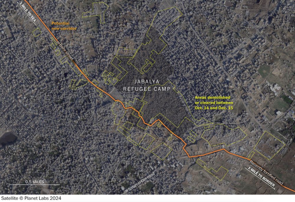
New clearings and demolitions over the last two months were concentrated in the south of Jabalya, flattening almost half of the camp, including the main market area.
As of Dec. 1, a third of all buildings across the North Gaza governate had been destroyed since the beginning of the war.
As of Dec. 1, a third of all buildings across the North Gaza governate had been destroyed since the beginning of the war.
December 23, 2024 at 5:31 PM
New clearings and demolitions over the last two months were concentrated in the south of Jabalya, flattening almost half of the camp, including the main market area.
As of Dec. 1, a third of all buildings across the North Gaza governate had been destroyed since the beginning of the war.
As of Dec. 1, a third of all buildings across the North Gaza governate had been destroyed since the beginning of the war.
The establishment of this corridor, the clearing of tracts of land on either side of it and the construction of square-shaped protected outposts resemble the IDF’s transformation of the Netzarim Corridor, a strategic Israeli military zone in the center of Gaza, analysts said.
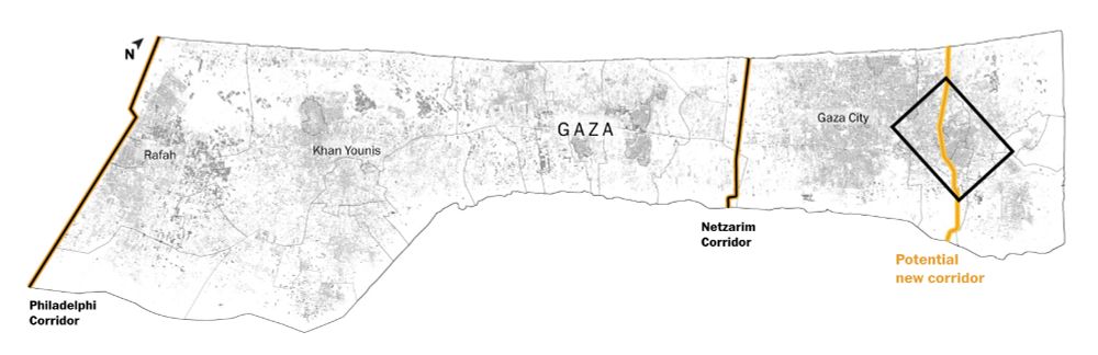
December 23, 2024 at 5:28 PM
The establishment of this corridor, the clearing of tracts of land on either side of it and the construction of square-shaped protected outposts resemble the IDF’s transformation of the Netzarim Corridor, a strategic Israeli military zone in the center of Gaza, analysts said.
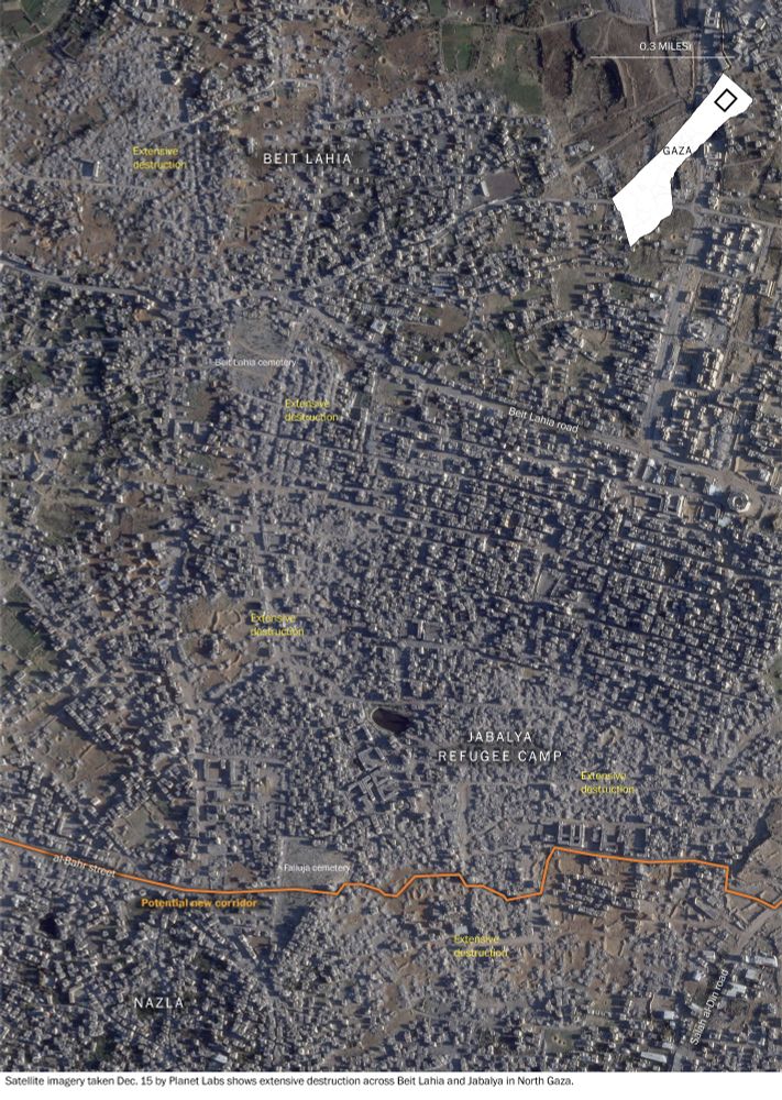
The visual evidence shows almost half of Jabalya refugee camp was demolished or cleared between Oct. 14 and Dec. 15, connecting a preexisting road in the west to an expanded vehicle track in the east — carving out a military axis that stretches from the sea to the border fence with Israel.
December 23, 2024 at 5:26 PM
The visual evidence shows almost half of Jabalya refugee camp was demolished or cleared between Oct. 14 and Dec. 15, connecting a preexisting road in the west to an expanded vehicle track in the east — carving out a military axis that stretches from the sea to the border fence with Israel.