


Hurricane Watch Team
@hurricanewatchteam.bsky.social
🚨Big news! The Hurricane Watch Team is now on TikTok and Instagram! 🌪️📲 Get your storm updates, satellite visuals, and tropical briefings in a whole new way. Follow us now! instagram.com/hurricane_wa... tiktok.com/@hurricanewa...

July 28, 2025 at 4:22 PM
🚨Big news! The Hurricane Watch Team is now on TikTok and Instagram! 🌪️📲 Get your storm updates, satellite visuals, and tropical briefings in a whole new way. Follow us now! instagram.com/hurricane_wa... tiktok.com/@hurricanewa...
COMING SOON: Our in-depth Tropical Briefings are coming soon — Atlantic to Pacific, every storm, every threat, broken down like never before.
🌊 Want early access & exclusive insights?
Join us on Patreon: patreon.com/HurricaneWat...
#Hurricane #Typhoon #TropicalUpdate #Patreon
🌊 Want early access & exclusive insights?
Join us on Patreon: patreon.com/HurricaneWat...
#Hurricane #Typhoon #TropicalUpdate #Patreon

July 25, 2025 at 9:36 AM
COMING SOON: Our in-depth Tropical Briefings are coming soon — Atlantic to Pacific, every storm, every threat, broken down like never before.
🌊 Want early access & exclusive insights?
Join us on Patreon: patreon.com/HurricaneWat...
#Hurricane #Typhoon #TropicalUpdate #Patreon
🌊 Want early access & exclusive insights?
Join us on Patreon: patreon.com/HurricaneWat...
#Hurricane #Typhoon #TropicalUpdate #Patreon
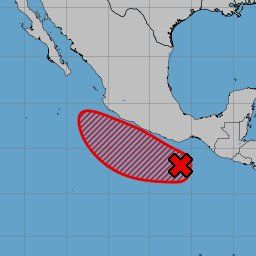
🌧️A broad area of low pressure may form off the SE U.S. coast in the coming days. Marginal conditions could allow slow development as it drifts westward across Florida and into the Gulf mid to late next week. Heavy rain possible either way. 🌊
#Hurricane #Florida #GulfCoast
#Hurricane #Florida #GulfCoast

July 12, 2025 at 6:59 PM
🌧️A broad area of low pressure may form off the SE U.S. coast in the coming days. Marginal conditions could allow slow development as it drifts westward across Florida and into the Gulf mid to late next week. Heavy rain possible either way. 🌊
#Hurricane #Florida #GulfCoast
#Hurricane #Florida #GulfCoast
BREAKING: Typhoon #Danas has made landfall on the southwestern coast of Taiwan. The powerful storm is hitting with max sustained winds of 90 kts (~167 km/h). Residents in the path, please stay safe and heed all official warnings. #TyphoonDanas #Taiwan #Weather

July 6, 2025 at 4:08 PM
BREAKING: Typhoon #Danas has made landfall on the southwestern coast of Taiwan. The powerful storm is hitting with max sustained winds of 90 kts (~167 km/h). Residents in the path, please stay safe and heed all official warnings. #TyphoonDanas #Taiwan #Weather
DANGER: Typhoon #Danas is on a collision course with Taiwan, landfall is expected in just a few hours. Expect destructive winds, extreme rain, and life-threatening storm surge and flooding for western Taiwan. Preparations must be complete NOW.
#TyphoonDanas #Taiwan #Typhoon
#TyphoonDanas #Taiwan #Typhoon

July 6, 2025 at 11:28 AM
DANGER: Typhoon #Danas is on a collision course with Taiwan, landfall is expected in just a few hours. Expect destructive winds, extreme rain, and life-threatening storm surge and flooding for western Taiwan. Preparations must be complete NOW.
#TyphoonDanas #Taiwan #Typhoon
#TyphoonDanas #Taiwan #Typhoon
Tropical Storm #Chantal is now inland over eastern South Carolina. The main threat is flash flooding from heavy rain.
A Tropical Storm Warning is in effect from South Santee River, SC to Surf City, NC. Expect strong winds & life-threatening surf. Monitor local alerts. #SCwx #NCwx
A Tropical Storm Warning is in effect from South Santee River, SC to Surf City, NC. Expect strong winds & life-threatening surf. Monitor local alerts. #SCwx #NCwx


July 6, 2025 at 10:23 AM


Tropical Storm #Danas is strengthening in the South China Sea, currently with winds of 60 kts (~70 mph). It's forecast to intensify into a typhoon as it tracks north toward the Taiwan Strait, posing a significant threat to both Taiwan and eastern China early next week. #Typhoon


July 5, 2025 at 2:30 PM
Hurricane #Flossie has passed its peak intensity in the Eastern Pacific. While still a strong Cat 2 hurricane with 110 mph winds, a steady weakening trend is now expected as it moves over cooler water. Forecast to become a post-tropical low by late Thursday.
#Hurricane #Weather
#Hurricane #Weather


July 2, 2025 at 3:32 PM
Hurricane #Flossie has passed its peak intensity in the Eastern Pacific. While still a strong Cat 2 hurricane with 110 mph winds, a steady weakening trend is now expected as it moves over cooler water. Forecast to become a post-tropical low by late Thursday.
#Hurricane #Weather
#Hurricane #Weather
🚨 #HuracánFlossie se fortalece a 160 km/h y se ubica a 240 km al suroeste de Manzanillo, Colima. Las bandas nubosas ya azotan la costa y podría alcanzar categoría mayor esta noche. ¡Mucho ojo! ⚠️🌪️
#México #Huracán #Flossie #AlertaClimática
#México #Huracán #Flossie #AlertaClimática


July 1, 2025 at 3:25 PM
🚨 #HuracánFlossie se fortalece a 160 km/h y se ubica a 240 km al suroeste de Manzanillo, Colima. Las bandas nubosas ya azotan la costa y podría alcanzar categoría mayor esta noche. ¡Mucho ojo! ⚠️🌪️
#México #Huracán #Flossie #AlertaClimática
#México #Huracán #Flossie #AlertaClimática
🚨#HurricaneFlossie strengthens to 100 mph as it churns 150 miles SW of Manzanillo, Mexico. Rainbands are lashing the coast, and further intensification is expected - possibly reaching major hurricane status tonight. 🌊#Mexico #Hurricane #Flossie #Huracan
July 1, 2025 at 3:22 PM
🚨#HurricaneFlossie strengthens to 100 mph as it churns 150 miles SW of Manzanillo, Mexico. Rainbands are lashing the coast, and further intensification is expected - possibly reaching major hurricane status tonight. 🌊#Mexico #Hurricane #Flossie #Huracan
WE'RE EXPANDING! 🌪️
The Hurricane Watch Team is looking for new volunteer members to join us! We're dedicated to providing timely and accurate tropical cyclone coverage.
Apply now! ➡️ forms.gle/1vgbuvzJUAtB...
#Weather #Hiring #Volunteer #Meteorology #Hurricane #JoinTheTeam #SciComm
The Hurricane Watch Team is looking for new volunteer members to join us! We're dedicated to providing timely and accurate tropical cyclone coverage.
Apply now! ➡️ forms.gle/1vgbuvzJUAtB...
#Weather #Hiring #Volunteer #Meteorology #Hurricane #JoinTheTeam #SciComm

June 30, 2025 at 1:44 PM
WE'RE EXPANDING! 🌪️
The Hurricane Watch Team is looking for new volunteer members to join us! We're dedicated to providing timely and accurate tropical cyclone coverage.
Apply now! ➡️ forms.gle/1vgbuvzJUAtB...
#Weather #Hiring #Volunteer #Meteorology #Hurricane #JoinTheTeam #SciComm
The Hurricane Watch Team is looking for new volunteer members to join us! We're dedicated to providing timely and accurate tropical cyclone coverage.
Apply now! ➡️ forms.gle/1vgbuvzJUAtB...
#Weather #Hiring #Volunteer #Meteorology #Hurricane #JoinTheTeam #SciComm
ÚLTIMA HORA: Se formó la Depresión Tropical 06E en el Pacífico. Podría intensificarse a huracán categoría 1 o 2, provocando vientos fuertes y lluvias significativas en la costa de México. Siguiente nombre: #Flossie.
#06E #DepresionTropical06E #México #Huracán
#06E #DepresionTropical06E #México #Huracán


June 29, 2025 at 8:57 AM
ÚLTIMA HORA: Se formó la Depresión Tropical 06E en el Pacífico. Podría intensificarse a huracán categoría 1 o 2, provocando vientos fuertes y lluvias significativas en la costa de México. Siguiente nombre: #Flossie.
#06E #DepresionTropical06E #México #Huracán
#06E #DepresionTropical06E #México #Huracán
BREAKING: Tropical Depression 06E has formed in the Eastern Pacific. The system could peak as a Category 1 - 2 hurricane while largely bringing gusty winds and significant rainfall to the Mexico coastline. Next name is #Flossie. #06E #TropicalDepression06E #Mexico #Huracan
June 29, 2025 at 8:52 AM
BREAKING: Tropical Depression 06E has formed in the Eastern Pacific. The system could peak as a Category 1 - 2 hurricane while largely bringing gusty winds and significant rainfall to the Mexico coastline. Next name is #Flossie. #06E #TropicalDepression06E #Mexico #Huracan
BREAKING: Tropical Depression 02L has formed in the Bay of Campeche. The system could become a brief tropical storm before making landfall in Mexico in around 24-36 hours. Next name is #Barry. #02L #TropicalDepression02L #Mexico #Huracan

June 28, 2025 at 8:36 PM
BREAKING: Tropical Depression 02L has formed in the Bay of Campeche. The system could become a brief tropical storm before making landfall in Mexico in around 24-36 hours. Next name is #Barry. #02L #TropicalDepression02L #Mexico #Huracan
¡Aguas, México! ⛈️ Se vigilan dos sistemas: #Invest95E en el Pacífico, que podría ser el huracán #Flossie, y el #Invest91L en el Golfo, que traerá lluvias muy fuertes. ¡A cuidarse!
#Mexico #Huracan #Lluvias #ClimaMX #ProteccionCivil
#Mexico #Huracan #Lluvias #ClimaMX #ProteccionCivil

June 28, 2025 at 7:54 PM
¡Aguas, México! ⛈️ Se vigilan dos sistemas: #Invest95E en el Pacífico, que podría ser el huracán #Flossie, y el #Invest91L en el Golfo, que traerá lluvias muy fuertes. ¡A cuidarse!
#Mexico #Huracan #Lluvias #ClimaMX #ProteccionCivil
#Mexico #Huracan #Lluvias #ClimaMX #ProteccionCivil
Invest 95E is quickly organizing and could become a tropical cyclone in the next day or two, perhaps become a hurricane later, with it potentially bringing significant rainfall and some gusty winds to coastal Mexico. Next name is #Flossie. #Mexico #Huracan #Invest95E #Hurricane


June 28, 2025 at 7:32 PM
Invest 95E is quickly organizing and could become a tropical cyclone in the next day or two, perhaps become a hurricane later, with it potentially bringing significant rainfall and some gusty winds to coastal Mexico. Next name is #Flossie. #Mexico #Huracan #Invest95E #Hurricane
Invest 91L is now likely to become a tropical cyclone in the Bay of Campeche before it strikes Mexico in the next day or two. While it should stay weak, significant rainfall is possible. #Invest91L #Mexico #TropicalStorm #HurricaneSeason


June 28, 2025 at 6:15 PM
Invest 91L is now likely to become a tropical cyclone in the Bay of Campeche before it strikes Mexico in the next day or two. While it should stay weak, significant rainfall is possible. #Invest91L #Mexico #TropicalStorm #HurricaneSeason
We're watching a tropical disturbance located in the Carribean expected to move into the Bay of Campeche, where the NHC is giving it a 20% chance of TC development. Regardless of formation, some enhanced rainfall is possible. #Hurricane #HurricaneSeason #Mexico


June 27, 2025 at 2:32 PM
We're watching a tropical disturbance located in the Carribean expected to move into the Bay of Campeche, where the NHC is giving it a 20% chance of TC development. Regardless of formation, some enhanced rainfall is possible. #Hurricane #HurricaneSeason #Mexico
We are watching the Bay of Campeche for a potential brief tropical disturbance or even a tropical depression around Sat to Mon. This scenario is primarily supported by AI guidance and some ensembles, albeit chances remain very low. #HurricaneSeason #Mexico

June 26, 2025 at 1:09 PM
We are watching the Bay of Campeche for a potential brief tropical disturbance or even a tropical depression around Sat to Mon. This scenario is primarily supported by AI guidance and some ensembles, albeit chances remain very low. #HurricaneSeason #Mexico
Tropical Depression 03W has formed in the Western Pacific. While the system is expected to stay weak, it could bring some rain to parts of China. #TropicalDepression03W #TropicalDepression #03W #China #Typhoon


June 25, 2025 at 8:30 AM
Tropical Depression 03W has formed in the Western Pacific. While the system is expected to stay weak, it could bring some rain to parts of China. #TropicalDepression03W #TropicalDepression #03W #China #Typhoon
Tropical Storm ANDREA has formed in the Atlantic, becoming the 1st storm of the 2025 Atlantic Hurricane Season. The system is expected to dissipate tomorrow far away from any land areas. Here's a quick video update. #TropicalStormAndrea #TropicalStorm #Andrea #HurricaneSeason
June 24, 2025 at 4:35 PM
Tropical Storm ANDREA has formed in the Atlantic, becoming the 1st storm of the 2025 Atlantic Hurricane Season. The system is expected to dissipate tomorrow far away from any land areas. Here's a quick video update. #TropicalStormAndrea #TropicalStorm #Andrea #HurricaneSeason
#BREAKING: Tropical Storm ANDREA has formed in the Atlantic, marking the 1st storm of the 2025 Atlantic Hurricane Season.. The system is expected to dissipate tomorrow far away from any land areas. #TropicalStormAndrea #TropicalStorm #Andrea #HurricaneSeason


June 24, 2025 at 2:17 PM
#BREAKING: Tropical Storm ANDREA has formed in the Atlantic, marking the 1st storm of the 2025 Atlantic Hurricane Season.. The system is expected to dissipate tomorrow far away from any land areas. #TropicalStormAndrea #TropicalStorm #Andrea #HurricaneSeason
Tropical Storm Sepat formed not long ago. While not expected to get particularly strong, the system is expected to head towards Japan, bringing some heavy rain. #TropicalStormSepat #TropicalStorm #Sepat #Japan #Tokyo #Storm #Weather #Typhoon


June 23, 2025 at 9:02 AM
Tropical Storm Sepat formed not long ago. While not expected to get particularly strong, the system is expected to head towards Japan, bringing some heavy rain. #TropicalStormSepat #TropicalStorm #Sepat #Japan #Tokyo #Storm #Weather #Typhoon
Invest 90L has formed in the North Atlantic, with a 20% chance of becoming a (sub)tropical depression or storm over the next day or two. No significant land impacts are expected. #HurricaneSeason #Invest90L #TropicalStorm #TropicalDepression #NorthAtlantic
June 22, 2025 at 5:57 PM
Invest 90L has formed in the North Atlantic, with a 20% chance of becoming a (sub)tropical depression or storm over the next day or two. No significant land impacts are expected. #HurricaneSeason #Invest90L #TropicalStorm #TropicalDepression #NorthAtlantic