


Richard Heatwave Berler
@heatwavekgns.bsky.social
I love weather! CBS Duluth, MN May 23, 1976-80, KGNS Laredo, TX Feb 14, 1980-now. NCEI/NWS coop site 415060 June 10, 1985 to December 31, 2023. NWS Jefferson Award. AMS CBM#18
Sunday 2:59 pm: Just Because Department: -60F/-51C in Kerbo in central Siberia. Unusually warm air, above 32F/0C west of the Ural Mountains.

November 30, 2025 at 9:01 PM
Sunday 2:59 pm: Just Because Department: -60F/-51C in Kerbo in central Siberia. Unusually warm air, above 32F/0C west of the Ural Mountains.
Sunday 7:55 am: Leading edge of much cooler airmass arrived at 6 am. Temperatures will remain in the 50’s all day, cloudy and breezy. An upper level disturbance passing above our cool airmass may bring some patches of rain late tonight/dawn Monday.


November 30, 2025 at 1:57 PM
Sunday 7:55 am: Leading edge of much cooler airmass arrived at 6 am. Temperatures will remain in the 50’s all day, cloudy and breezy. An upper level disturbance passing above our cool airmass may bring some patches of rain late tonight/dawn Monday.
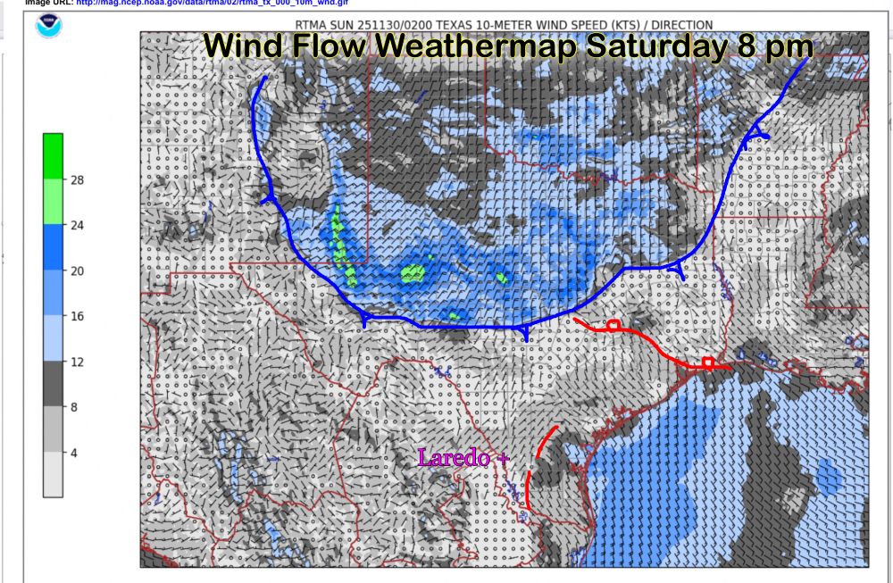
Saturday 9:04 pm: Cold front entering Hill Country, may take until 6 to 7 am, near dawn to reach Laredo. Slight early morning shower chance, cloudy breezy day, 50’s all day.
November 30, 2025 at 3:05 AM
Saturday 9:04 pm: Cold front entering Hill Country, may take until 6 to 7 am, near dawn to reach Laredo. Slight early morning shower chance, cloudy breezy day, 50’s all day.
Before my analysis:

November 30, 2025 at 2:32 AM
Before my analysis:
Saturday 7:14 pm: Big Picture Weathermap: Cold front is surging south, cold north wind will arrive ~5 am. Slight brief shower chance, then cloudy, 50’s all day, showers late Sunday night/dawn Monday as upper level disturbance moves above our hilly north wind.

November 30, 2025 at 1:17 AM
Saturday 7:14 pm: Big Picture Weathermap: Cold front is surging south, cold north wind will arrive ~5 am. Slight brief shower chance, then cloudy, 50’s all day, showers late Sunday night/dawn Monday as upper level disturbance moves above our hilly north wind.
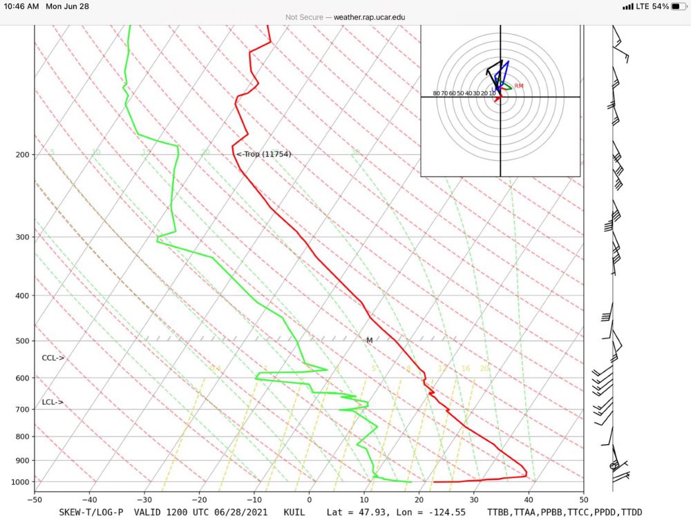
Excellent example of bimodal distribution. The Pacific coast of the U.S. is an example as they are marine dominated, but have a non-trivial outlier population of hot dry downsloping events. Quillayute, Washington is an example with 110F in June 2021 when hot dry subsiding air arrived at the surface!
November 29, 2025 at 5:16 PM
Excellent example of bimodal distribution. The Pacific coast of the U.S. is an example as they are marine dominated, but have a non-trivial outlier population of hot dry downsloping events. Quillayute, Washington is an example with 110F in June 2021 when hot dry subsiding air arrived at the surface!
Saturday 9:48 am: Warm air has arrived at the surface, clearing, low/mid 80’s this pm. Cold front arrives ~4 am Sunday slight shower chance. Cloudy breezy much colder Sunday, low/mid 50’s. Moisture/upper level disturbance above our cool air brings showers/40’s before dawn Monday.


November 29, 2025 at 3:49 PM
Saturday 9:48 am: Warm air has arrived at the surface, clearing, low/mid 80’s this pm. Cold front arrives ~4 am Sunday slight shower chance. Cloudy breezy much colder Sunday, low/mid 50’s. Moisture/upper level disturbance above our cool air brings showers/40’s before dawn Monday.
Friday 4:55 pm: Big Picture Weathermap: Warm air has returned aloft, and will arrive at the surface by midday Saturday. Clearing skies, low 80’s pm. Colder air, now into northern Wyoming will race southward, arriving ~dawn Sunday with chance of shower. 50’s Sunday afternoon.

November 28, 2025 at 10:56 PM
Friday 4:55 pm: Big Picture Weathermap: Warm air has returned aloft, and will arrive at the surface by midday Saturday. Clearing skies, low 80’s pm. Colder air, now into northern Wyoming will race southward, arriving ~dawn Sunday with chance of shower. 50’s Sunday afternoon.
Friday 9:19 am: Warm moist air is flowing north above our cool airmass. This brings cloudy skies with patches of drizzle/light rain. Some breaks in cloud possible late pm, ~70F. The cool airmass erodes away, allowing the warm winds to arrive at the surface, low 80’s Saturday pm.

November 28, 2025 at 3:21 PM
Friday 9:19 am: Warm moist air is flowing north above our cool airmass. This brings cloudy skies with patches of drizzle/light rain. Some breaks in cloud possible late pm, ~70F. The cool airmass erodes away, allowing the warm winds to arrive at the surface, low 80’s Saturday pm.
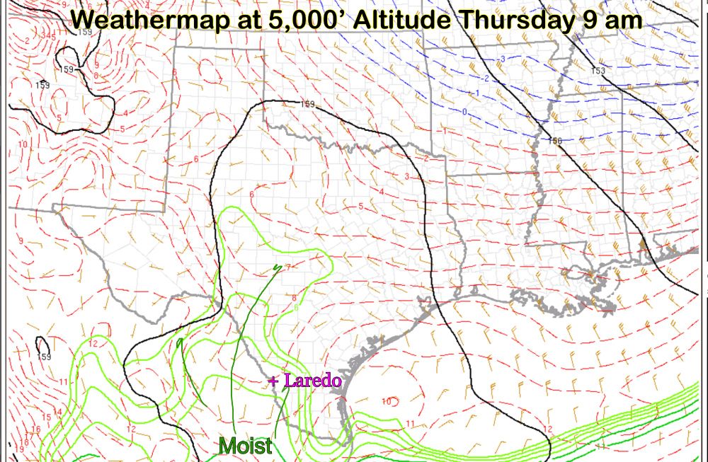
Thursday 4 pm: Big Picture Weathermap: A layer of moist air at ~5,000' altitude is moving above our slowly moistening air below. A thickening cloud deck, ~60 overnight, a few patches of light rain possible late tonight, Friday. ~70F Friday afternoon.

November 27, 2025 at 10:01 PM
Thursday 4 pm: Big Picture Weathermap: A layer of moist air at ~5,000' altitude is moving above our slowly moistening air below. A thickening cloud deck, ~60 overnight, a few patches of light rain possible late tonight, Friday. ~70F Friday afternoon.
Thursday 2:26 pm: Just Because Department: Very cold air is expanding across most of Russia east of the Ural Mountains.

November 27, 2025 at 8:27 PM
Thursday 2:26 pm: Just Because Department: Very cold air is expanding across most of Russia east of the Ural Mountains.
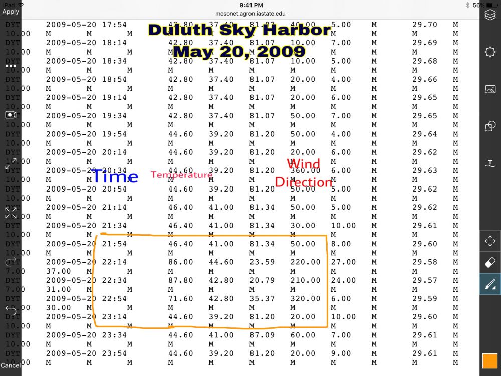
This could produce incredibly quick temperature changes at lakeside/downtown when hot air just over the hill would briefly appear at lakeside, only to be replaced by lake air. An hour on May 20, 2009:
November 27, 2025 at 5:44 PM
This could produce incredibly quick temperature changes at lakeside/downtown when hot air just over the hill would briefly appear at lakeside, only to be replaced by lake air. An hour on May 20, 2009:
Thursday 9:52 am: A cool airmass is capped by moist southerly winds at ~5,000’ altitude bringing a deck of stratus. This is a mostly cloudy and cool combination with high 60’s to around 70 pm.

November 27, 2025 at 3:53 PM
Thursday 9:52 am: A cool airmass is capped by moist southerly winds at ~5,000’ altitude bringing a deck of stratus. This is a mostly cloudy and cool combination with high 60’s to around 70 pm.
Wednesday 4:03 pm: Big Picture Weathermap: A cool dry airmass held temperatures just above 70 this afternoon. 50's, partly cloudy toward dawn. partly cloudy Thanksgiving with mostly cloudy skies returning in the afternoon/evening.

November 26, 2025 at 10:05 PM
Wednesday 4:03 pm: Big Picture Weathermap: A cool dry airmass held temperatures just above 70 this afternoon. 50's, partly cloudy toward dawn. partly cloudy Thanksgiving with mostly cloudy skies returning in the afternoon/evening.
Wednesday 8:52 am: Patch of light rain/sprinkles moving into Laredo.

November 26, 2025 at 2:54 PM
Wednesday 8:52 am: Patch of light rain/sprinkles moving into Laredo.
Wednesday 8:24 am: Cooler air has arrived, mostly cloudy, some sun at times, low 70’s. 1”-2” of rain fell in Mines Road, west, downtown, and south Laredo, .5”-1” Lake Casa Blanca north through Del Mar and north Laredo. Rains becoming more widespread in Zapata County this a.m.


November 26, 2025 at 2:25 PM
Wednesday 8:24 am: Cooler air has arrived, mostly cloudy, some sun at times, low 70’s. 1”-2” of rain fell in Mines Road, west, downtown, and south Laredo, .5”-1” Lake Casa Blanca north through Del Mar and north Laredo. Rains becoming more widespread in Zapata County this a.m.
Wednesday 5:17 am: A thunderstorm is moving into our area. Heavy rain as it moves through.

November 26, 2025 at 11:19 AM
Wednesday 5:17 am: A thunderstorm is moving into our area. Heavy rain as it moves through.
Wednesday 12:07 am: Showers are moving east along hwy 359 from near Laredo Ranchettes to Oilton, also just east of Bruni. A thunderstorm is over northern rural Zapata County.

November 26, 2025 at 6:08 AM
Wednesday 12:07 am: Showers are moving east along hwy 359 from near Laredo Ranchettes to Oilton, also just east of Bruni. A thunderstorm is over northern rural Zapata County.
Tuesday 11:22 pm: Thunderstorms are weaker, none at a severe level at this point. None near Laredo at this point, but our area could still have more scattered showers form until cold front passes through near dawn.

November 26, 2025 at 5:23 AM
Tuesday 11:22 pm: Thunderstorms are weaker, none at a severe level at this point. None near Laredo at this point, but our area could still have more scattered showers form until cold front passes through near dawn.
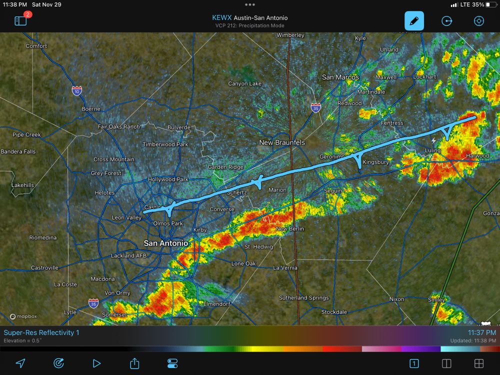
Tuesday 10:04 pm: Very unusual for a late November storm, the top of the thunderstorm has reached as high as an altitude of 60,000’. 2” diameter hail is indicated with this storm. The emphasis is near Aguilares as it crosses highway 359.


November 26, 2025 at 4:06 AM
Tuesday 10:04 pm: Very unusual for a late November storm, the top of the thunderstorm has reached as high as an altitude of 60,000’. 2” diameter hail is indicated with this storm. The emphasis is near Aguilares as it crosses highway 359.
Tuesday 9:50 pm: Severe Thunderstorm Warning now for Aguilares to Mirando City/Oilton until 10:30 for severe thunderstorm about to cross highway 359. Hail 1-2” in diameter with the storm.

November 26, 2025 at 3:51 AM
Tuesday 9:50 pm: Severe Thunderstorm Warning now for Aguilares to Mirando City/Oilton until 10:30 for severe thunderstorm about to cross highway 359. Hail 1-2” in diameter with the storm.
Tuesday 9:34 pm: Severe Thunderstorm Warning until 10 pm for strong storm in far south rural Webb County:

November 26, 2025 at 3:34 AM
Tuesday 9:34 pm: Severe Thunderstorm Warning until 10 pm for strong storm in far south rural Webb County:
Tuesday 9:24 pm: Thundershower in northern Zapata County has weakened, no longer sever. The storm just north of the Zapata line is strengthening, small hail indicated.

November 26, 2025 at 3:25 AM
Tuesday 9:24 pm: Thundershower in northern Zapata County has weakened, no longer sever. The storm just north of the Zapata line is strengthening, small hail indicated.
My 21 UTC U.S. analysis:

November 26, 2025 at 3:20 AM
My 21 UTC U.S. analysis: