

Harold Tobin
@haroldtobin.bsky.social
UW prof and director of the Pacific Northwest Seismic Network. WA State Seismologist. All about subduction zones and very messed up rocks.
In a closed space behind the scenes, not too far from the 3rd base line.
October 18, 2025 at 1:35 AM
In a closed space behind the scenes, not too far from the 3rd base line.
Those Canadian home runs don’t make much of a signal here for some reason 🧐
October 16, 2025 at 1:34 AM
Those Canadian home runs don’t make much of a signal here for some reason 🧐

Julio Rodriguez HOME RUN! You don't need to be a scientist to see a BIG moment like that. Great start to game 3!
# SeizeTheMoment
@Mariners @TMobilePark @FoxSports
# SeizeTheMoment
@Mariners @TMobilePark @FoxSports

October 16, 2025 at 1:33 AM
Correction: near Tosa, not Kure.
September 29, 2025 at 12:42 PM
Correction: near Tosa, not Kure.
These communities’ entire way of life is based on fishing and having the harbor. Surrounding terrain is very steep and rugged except at the river mouths. Meanwhile, the entire nation is subject to earthquake damage. So just leaving is not as strategic as it sounds…
September 29, 2025 at 12:38 PM
These communities’ entire way of life is based on fishing and having the harbor. Surrounding terrain is very steep and rugged except at the river mouths. Meanwhile, the entire nation is subject to earthquake damage. So just leaving is not as strategic as it sounds…
Yes! In the 2011 tsunami in Japan, the numerous designated tsunami-evacuation buildings saved many thousands of lives. They didn’t have special purpose towers there, as far as I know. But southern Japan has many, especially in places like Kure without tall buildings, as seen in my pics.
September 29, 2025 at 2:28 AM
Yes! In the 2011 tsunami in Japan, the numerous designated tsunami-evacuation buildings saved many thousands of lives. They didn’t have special purpose towers there, as far as I know. But southern Japan has many, especially in places like Kure without tall buildings, as seen in my pics.
Yes, we do like them - very much.
September 12, 2025 at 5:34 AM
Yes, we do like them - very much.
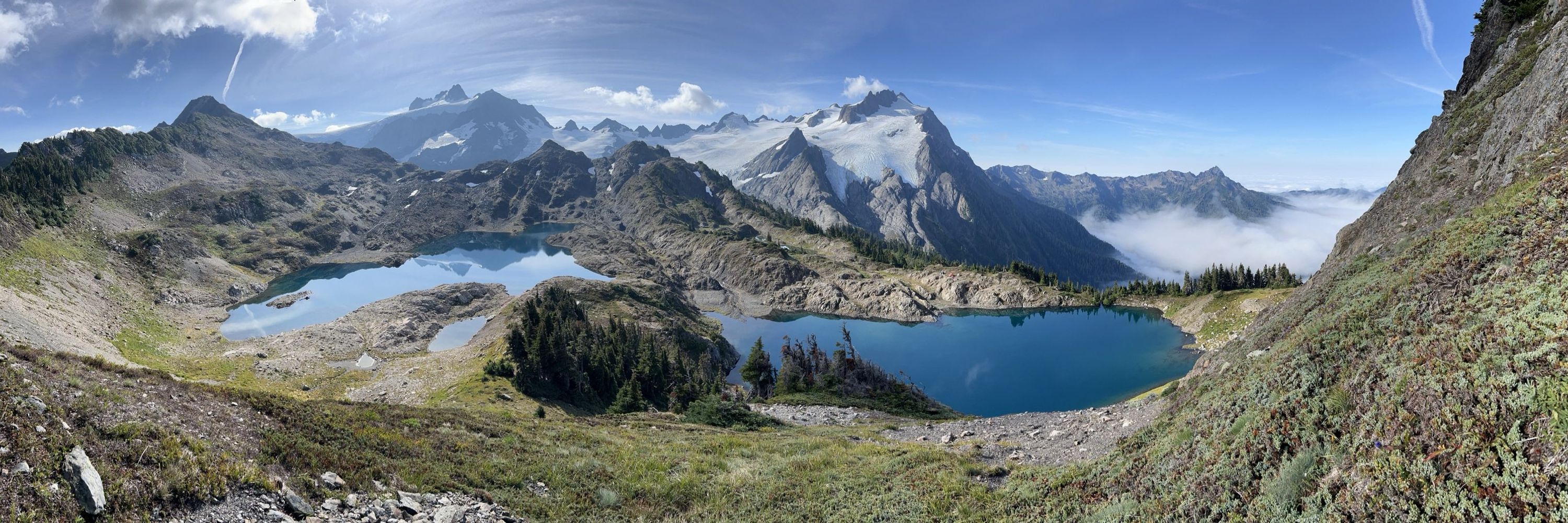
We spent 15 days up there, and saw no sign of other people. Pretty amazing, when we were in the heart of a well-known national park and less than 70 miles from UW campus! But a hard place to get to: we needed helicopter support to do this work.


September 12, 2025 at 5:30 AM
We spent 15 days up there, and saw no sign of other people. Pretty amazing, when we were in the heart of a well-known national park and less than 70 miles from UW campus! But a hard place to get to: we needed helicopter support to do this work.
Their website says “Note that while this model output represents the latest research modeling at NCTR, the operational forecast is performed at NOAA's Tsunami Warning Centers (TWCs) using the same technology.”
August 3, 2025 at 5:46 PM
Their website says “Note that while this model output represents the latest research modeling at NCTR, the operational forecast is performed at NOAA's Tsunami Warning Centers (TWCs) using the same technology.”
Yes, I did kind of blend them to simplify the story. I understood from the website that they both use the exact same method to hand off the deep water model to the inundation one so I thought it was a minor point - but maybe not!
August 3, 2025 at 5:43 PM
Yes, I did kind of blend them to simplify the story. I understood from the website that they both use the exact same method to hand off the deep water model to the inundation one so I thought it was a minor point - but maybe not!
They ran these models very early in the hours of the tsunami's trip across the ocean, fueling the accurate and timely warnings. (6/6)
August 2, 2025 at 5:15 PM
They ran these models very early in the hours of the tsunami's trip across the ocean, fueling the accurate and timely warnings. (6/6)
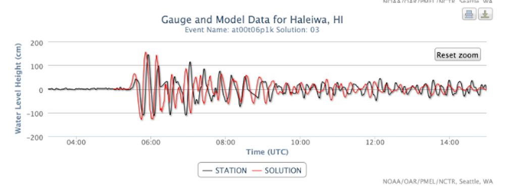
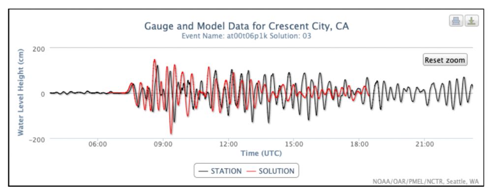
They then could hand off that open ocean tsunami model to coastal inundation models that were pre-computed. Here are some examples from Haleiwa, HI and Crescent City, CA. Looks like they did very well with both timing and amplitude! (5/6)
August 2, 2025 at 5:15 PM
They then could hand off that open ocean tsunami model to coastal inundation models that were pre-computed. Here are some examples from Haleiwa, HI and Crescent City, CA. Looks like they did very well with both timing and amplitude! (5/6)
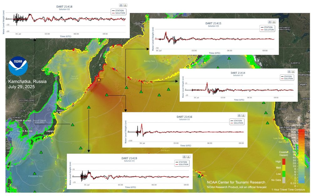
AS the tsunami passed other DART buoys, they could calibrate and verify the model. This image shows comparison of the model and the observed waves at various DART sites, showing great agreement. (4/6)
August 2, 2025 at 5:15 PM
AS the tsunami passed other DART buoys, they could calibrate and verify the model. This image shows comparison of the model and the observed waves at various DART sites, showing great agreement. (4/6)