


@gslsentinel.bsky.social
The Great Salt Lake's unofficial watchdog, blending hydrology with weather watch, advocating for natural precipitation and better water management over conservation myths.
A list of reservoirs in the GSL basin.
Looking at this list exemplifies how problematic past #GreatSaltLake studies have been in omitting their retention and evaporation as a large portion of flows missing from GSL.
It has let policy make decisions on half of the information needed.
Looking at this list exemplifies how problematic past #GreatSaltLake studies have been in omitting their retention and evaporation as a large portion of flows missing from GSL.
It has let policy make decisions on half of the information needed.

October 31, 2025 at 9:39 PM
A list of reservoirs in the GSL basin.
Looking at this list exemplifies how problematic past #GreatSaltLake studies have been in omitting their retention and evaporation as a large portion of flows missing from GSL.
It has let policy make decisions on half of the information needed.
Looking at this list exemplifies how problematic past #GreatSaltLake studies have been in omitting their retention and evaporation as a large portion of flows missing from GSL.
It has let policy make decisions on half of the information needed.

#GreatSaltLake management has opportunity to effect positive change through informed and innovative practice of capping reservoir storage.
#utah #slowtheflow #waterwise #utpol #utleg
#utah #slowtheflow #waterwise #utpol #utleg

October 17, 2025 at 7:39 PM
#GreatSaltLake management has opportunity to effect positive change through informed and innovative practice of capping reservoir storage.
#utah #slowtheflow #waterwise #utpol #utleg
#utah #slowtheflow #waterwise #utpol #utleg
Utah Division of natural Recourses published Municiple and Industrial: Water Conservation opportunities.
I did a review of the information on twitter.
It was if there were no hydrology involved.
Propaganda to sway politicians in order to increase funding.
I did a review of the information on twitter.
It was if there were no hydrology involved.
Propaganda to sway politicians in order to increase funding.

October 5, 2025 at 6:02 PM
Utah Division of natural Recourses published Municiple and Industrial: Water Conservation opportunities.
I did a review of the information on twitter.
It was if there were no hydrology involved.
Propaganda to sway politicians in order to increase funding.
I did a review of the information on twitter.
It was if there were no hydrology involved.
Propaganda to sway politicians in order to increase funding.
#GSL excessive reservoir storage water year end
Bear River Basin 56%, 777,000 acre-feet
Jordan River Basin 76%, 1,003,000 acre-feet
Weber River Basin 52%, 283,200 acre-feet
Bear River Basin 56%, 777,000 acre-feet
Jordan River Basin 76%, 1,003,000 acre-feet
Weber River Basin 52%, 283,200 acre-feet

September 30, 2025 at 7:39 PM
#GSL excessive reservoir storage water year end
Bear River Basin 56%, 777,000 acre-feet
Jordan River Basin 76%, 1,003,000 acre-feet
Weber River Basin 52%, 283,200 acre-feet
Bear River Basin 56%, 777,000 acre-feet
Jordan River Basin 76%, 1,003,000 acre-feet
Weber River Basin 52%, 283,200 acre-feet
#GreatSaltLake water year end
2025 GSL lost 1.5' year over year.
Still a gain of 2.5' over 2022' low elevation of 4188.5'
Average snowpack, below average summer precipitation ending at 85% of median.
2025 GSL lost 1.5' year over year.
Still a gain of 2.5' over 2022' low elevation of 4188.5'
Average snowpack, below average summer precipitation ending at 85% of median.

September 30, 2025 at 7:37 PM
#GreatSaltLake water year end
2025 GSL lost 1.5' year over year.
Still a gain of 2.5' over 2022' low elevation of 4188.5'
Average snowpack, below average summer precipitation ending at 85% of median.
2025 GSL lost 1.5' year over year.
Still a gain of 2.5' over 2022' low elevation of 4188.5'
Average snowpack, below average summer precipitation ending at 85% of median.
Citation as of 9/26/2025
*Willard is low due to maintenance.
*Willard is low due to maintenance.

September 27, 2025 at 2:55 AM
Citation as of 9/26/2025
*Willard is low due to maintenance.
*Willard is low due to maintenance.

The story made a big deal about soil moisture, so I checked.
considering the dry summer, it looks pretty damn good.
considering the dry summer, it looks pretty damn good.

September 3, 2025 at 5:30 AM
The story made a big deal about soil moisture, so I checked.
considering the dry summer, it looks pretty damn good.
considering the dry summer, it looks pretty damn good.
Kind of silly.
KSL did a story on reservoirs. We are at the end of the water year. We had a dry summer. Jordanelle is still almost 80% full, the rest as you can see are above 60%.
Every year we get snow. The reservoirs will replenish. Water is not scarce, it is mismanaged.
KSL did a story on reservoirs. We are at the end of the water year. We had a dry summer. Jordanelle is still almost 80% full, the rest as you can see are above 60%.
Every year we get snow. The reservoirs will replenish. Water is not scarce, it is mismanaged.

September 3, 2025 at 5:05 AM
Kind of silly.
KSL did a story on reservoirs. We are at the end of the water year. We had a dry summer. Jordanelle is still almost 80% full, the rest as you can see are above 60%.
Every year we get snow. The reservoirs will replenish. Water is not scarce, it is mismanaged.
KSL did a story on reservoirs. We are at the end of the water year. We had a dry summer. Jordanelle is still almost 80% full, the rest as you can see are above 60%.
Every year we get snow. The reservoirs will replenish. Water is not scarce, it is mismanaged.
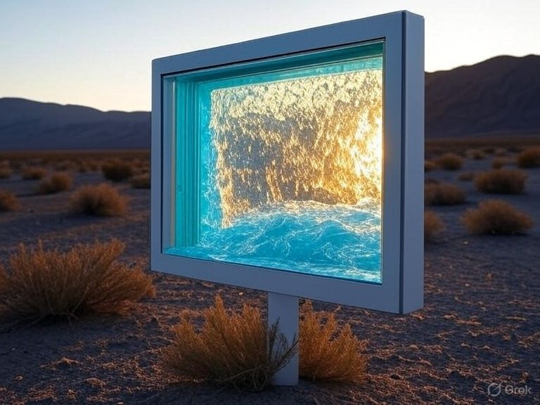
😉Scrying #GreatSaltLake water basin's future
Imagine a future in which vinyl fences are replaced by air water harvest panels! #waterwise #waterconservation #environment
Imagine a future in which vinyl fences are replaced by air water harvest panels! #waterwise #waterconservation #environment

July 13, 2025 at 9:14 PM
😉Scrying #GreatSaltLake water basin's future
Imagine a future in which vinyl fences are replaced by air water harvest panels! #waterwise #waterconservation #environment
Imagine a future in which vinyl fences are replaced by air water harvest panels! #waterwise #waterconservation #environment
The north arm of the #GreatSaltLake is 0.6' above last year.

May 28, 2025 at 3:33 AM
The north arm of the #GreatSaltLake is 0.6' above last year.
Governor cox is getting more bad advice from the politician he installed to lead the DNR. Making an unnecessary drought decree. A couple of counties, okay. Ferry is an alarmist, remember the "nuclear time bomb", then the lake grew. He can't be trusted. Another way to get a hold of tax funds?


April 25, 2025 at 2:31 AM
Governor cox is getting more bad advice from the politician he installed to lead the DNR. Making an unnecessary drought decree. A couple of counties, okay. Ferry is an alarmist, remember the "nuclear time bomb", then the lake grew. He can't be trusted. Another way to get a hold of tax funds?
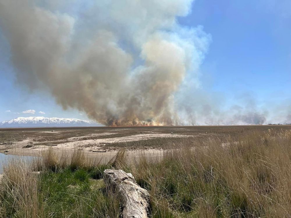
#GreatSaltLake dust monitoring is complicated
Even more complicated when UTDNR is contaminating samples by burning phragmite, like today.
Ogden pollution is elevated today in the path of the smoke column
Even more complicated when UTDNR is contaminating samples by burning phragmite, like today.
Ogden pollution is elevated today in the path of the smoke column


April 22, 2025 at 6:31 PM
#GreatSaltLake dust monitoring is complicated
Even more complicated when UTDNR is contaminating samples by burning phragmite, like today.
Ogden pollution is elevated today in the path of the smoke column
Even more complicated when UTDNR is contaminating samples by burning phragmite, like today.
Ogden pollution is elevated today in the path of the smoke column
I miscalculated or data source changed.
#GreatSaltLake sciences
In the 2023 water year, Human consumption was only 5% of water yield instead of 23.3%.
Total yield 35,700,000 acre-ft.
Human consumption (HC) 1,786,539 acre-ft.
Agriculture depleted 75.8% of the human consumption, only 4% of yield.
#GreatSaltLake sciences
In the 2023 water year, Human consumption was only 5% of water yield instead of 23.3%.
Total yield 35,700,000 acre-ft.
Human consumption (HC) 1,786,539 acre-ft.
Agriculture depleted 75.8% of the human consumption, only 4% of yield.

April 11, 2025 at 8:42 PM
I miscalculated or data source changed.
#GreatSaltLake sciences
In the 2023 water year, Human consumption was only 5% of water yield instead of 23.3%.
Total yield 35,700,000 acre-ft.
Human consumption (HC) 1,786,539 acre-ft.
Agriculture depleted 75.8% of the human consumption, only 4% of yield.
#GreatSaltLake sciences
In the 2023 water year, Human consumption was only 5% of water yield instead of 23.3%.
Total yield 35,700,000 acre-ft.
Human consumption (HC) 1,786,539 acre-ft.
Agriculture depleted 75.8% of the human consumption, only 4% of yield.
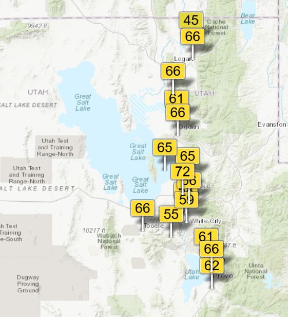
Today's slight wind pattern is from the SLC direction across the GSL. 65 Farmington Bay, 72 Rose Park.
Which is impacting which?
#GreatSaltLake
Which is impacting which?
#GreatSaltLake
April 10, 2025 at 6:23 PM
Today's slight wind pattern is from the SLC direction across the GSL. 65 Farmington Bay, 72 Rose Park.
Which is impacting which?
#GreatSaltLake
Which is impacting which?
#GreatSaltLake
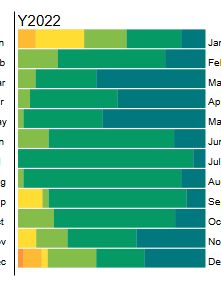
Air quality 2022. closer to the GSL. Image 1-Rose Park vs. image 2-Farmington Bay playa.
Rather than the GSL contaminating urban areas, it appears urban areas emit more pollution.
Rather than the GSL contaminating urban areas, it appears urban areas emit more pollution.


April 7, 2025 at 3:39 PM
Air quality 2022. closer to the GSL. Image 1-Rose Park vs. image 2-Farmington Bay playa.
Rather than the GSL contaminating urban areas, it appears urban areas emit more pollution.
Rather than the GSL contaminating urban areas, it appears urban areas emit more pollution.
Air quality 2022, GSL's lowest elevation year, exposing the most bed. Image 1- near road SLC vs. image 2- Farmington Bay playa.

April 7, 2025 at 3:26 PM
Air quality 2022, GSL's lowest elevation year, exposing the most bed. Image 1- near road SLC vs. image 2- Farmington Bay playa.
Tracking #GreatSaltLake growth
Up to 4193.5' today.
Up 1.4' on the season
Up 5' above November 2022's low elevation.
Instead of receding the GSL has been gaining elevation for 2.5 years thanks to nature.
misjudgments happen when claims are made without preforming the work.
Up to 4193.5' today.
Up 1.4' on the season
Up 5' above November 2022's low elevation.
Instead of receding the GSL has been gaining elevation for 2.5 years thanks to nature.
misjudgments happen when claims are made without preforming the work.

April 3, 2025 at 2:13 PM
Tracking #GreatSaltLake growth
Up to 4193.5' today.
Up 1.4' on the season
Up 5' above November 2022's low elevation.
Instead of receding the GSL has been gaining elevation for 2.5 years thanks to nature.
misjudgments happen when claims are made without preforming the work.
Up to 4193.5' today.
Up 1.4' on the season
Up 5' above November 2022's low elevation.
Instead of receding the GSL has been gaining elevation for 2.5 years thanks to nature.
misjudgments happen when claims are made without preforming the work.
Precipitation map

April 1, 2025 at 2:25 PM
Precipitation map
Burns are performed in areas close to dust monitoring sites and Wasatch Front communities.

March 31, 2025 at 8:41 PM
Burns are performed in areas close to dust monitoring sites and Wasatch Front communities.
Just a little more pollution than a campfire😉

March 31, 2025 at 8:40 PM
Just a little more pollution than a campfire😉
PM2.5 pollution caused by phragmite burns has been impacting the GSL playa for decades.
A 2024 burn and 2008 burn:
A 2024 burn and 2008 burn:

March 31, 2025 at 8:39 PM
PM2.5 pollution caused by phragmite burns has been impacting the GSL playa for decades.
A 2024 burn and 2008 burn:
A 2024 burn and 2008 burn:
1/
The rain gauge for the #GreatSaltLake water basin.
green- periods of higher precipitation.
Red- periods of low precipitation.
Inspired by the Feb. 2023 growth lull.
The rain gauge for the #GreatSaltLake water basin.
green- periods of higher precipitation.
Red- periods of low precipitation.
Inspired by the Feb. 2023 growth lull.

March 30, 2025 at 4:08 PM
1/
The rain gauge for the #GreatSaltLake water basin.
green- periods of higher precipitation.
Red- periods of low precipitation.
Inspired by the Feb. 2023 growth lull.
The rain gauge for the #GreatSaltLake water basin.
green- periods of higher precipitation.
Red- periods of low precipitation.
Inspired by the Feb. 2023 growth lull.
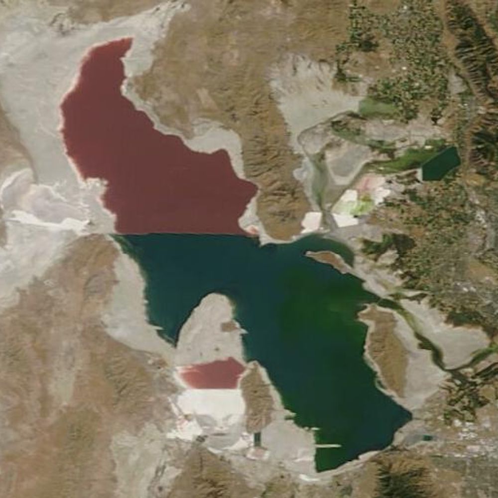
Shown here are red dots on a map of the #GreatSaltLake indicating all of the potentially toxic O2 hotspots. 😜

March 29, 2025 at 6:09 AM
Shown here are red dots on a map of the #GreatSaltLake indicating all of the potentially toxic O2 hotspots. 😜