


Good Map Bad Map
@goodmapbadmap.bsky.social
The blurry line between art and science.
Here for the open data, geospatial, product design, radical cartography, EO, cloud-native & open-source tech chatter, but I don’t mind motorbikes, cacti, geology, or anything Unreal engine either.
Here for the open data, geospatial, product design, radical cartography, EO, cloud-native & open-source tech chatter, but I don’t mind motorbikes, cacti, geology, or anything Unreal engine either.
Reposted by Good Map Bad Map
Point clouds editing coming to @qgis.fosstodon.org.ap.brid.gy
January 22, 2025 at 7:59 AM
Point clouds editing coming to @qgis.fosstodon.org.ap.brid.gy
Reposted by Good Map Bad Map

Hi Bluesky! We're welcoming in 2025 with a new Kart release. v0.16 includes significant speed improvements to vector & tabular data handling. Download from kartproject.org or read more at github.com/koordinates/...

Kart
Distributed version-control for geospatial and tabular data
kartproject.org
January 8, 2025 at 3:41 AM
Hi Bluesky! We're welcoming in 2025 with a new Kart release. v0.16 includes significant speed improvements to vector & tabular data handling. Download from kartproject.org or read more at github.com/koordinates/...
Reposted by Good Map Bad Map

#orienteering is certainly the best sport on earth for #map and #cartography lovers: It's outdoor, in the nature, you visit 'uncharted' areas of your neighborhood and apply multicriteria route optimisation algorithms. Maybe the sport you need for 2025 ?!
#gischat #sport #iof
#gischat #sport #iof


December 9, 2024 at 7:54 PM
#orienteering is certainly the best sport on earth for #map and #cartography lovers: It's outdoor, in the nature, you visit 'uncharted' areas of your neighborhood and apply multicriteria route optimisation algorithms. Maybe the sport you need for 2025 ?!
#gischat #sport #iof
#gischat #sport #iof
Reposted by Good Map Bad Map


December 8, 2024 at 12:20 PM
Reposted by Good Map Bad Map
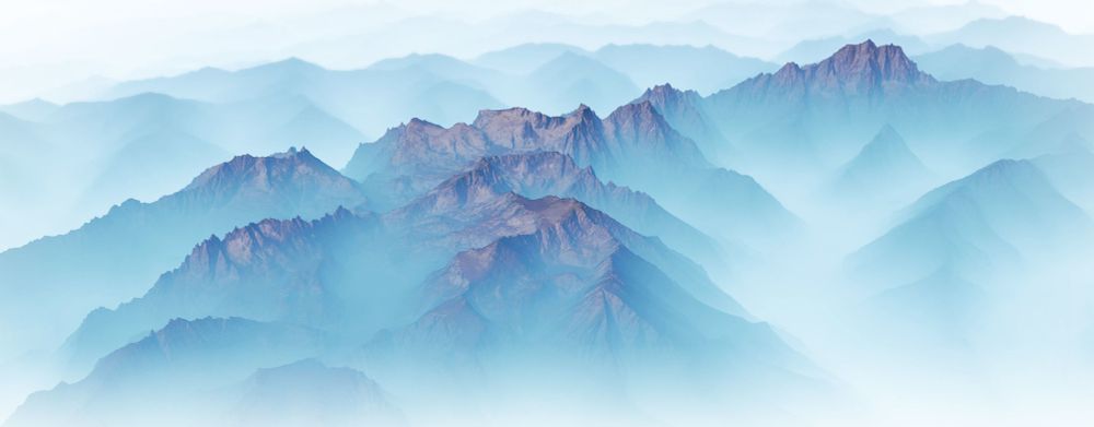
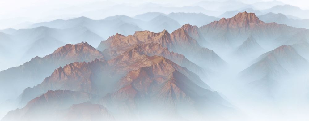
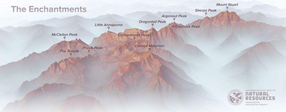
New #lidar images of the #Enchantments for the Washington Geological Survey. #PNW #Maps #CascadeRange

December 8, 2024 at 12:58 AM
New #lidar images of the #Enchantments for the Washington Geological Survey. #PNW #Maps #CascadeRange
Reposted by Good Map Bad Map
Working on our regional-scale point coud vis capabilities at Koordinates. Several hundred GBs of data previewed. Scaling up to TBs soon. And of course with clip & ship downloads, format and CRS shift, API access, version control built it. #gischat
October 1, 2024 at 3:13 AM
Working on our regional-scale point coud vis capabilities at Koordinates. Several hundred GBs of data previewed. Scaling up to TBs soon. And of course with clip & ship downloads, format and CRS shift, API access, version control built it. #gischat
Reposted by Good Map Bad Map
Those styles were based partly on this set by @timlinux.bsky.social plugins.qgis.org/styles/149/ and this set by Warren Davison www.esri.com/about/newsro... which I imported to #QGIS using the #SLYR plugin by @north-road.com

Stylish Landscapes
GIS analyst Warren Davison of Ontario, Canada, created Draft Sketch, a very artistic ArcGIS Pro style for landscape design and site planning.
www.esri.com
December 2, 2024 at 7:01 AM
Those styles were based partly on this set by @timlinux.bsky.social plugins.qgis.org/styles/149/ and this set by Warren Davison www.esri.com/about/newsro... which I imported to #QGIS using the #SLYR plugin by @north-road.com
Reposted by Good Map Bad Map

Reposted by Good Map Bad Map


November 25, 2024 at 10:05 PM
Reposted by Good Map Bad Map
Artist Olivia de Recat has created minimalist illustrations using two lines to depict the evolution of various relationships over time.
Olivia has published a book titled "Drawn Together: Illustrated True Love Stories”
#dataviz #datastories #relationships
Olivia has published a book titled "Drawn Together: Illustrated True Love Stories”
#dataviz #datastories #relationships

November 25, 2024 at 2:14 PM
Artist Olivia de Recat has created minimalist illustrations using two lines to depict the evolution of various relationships over time.
Olivia has published a book titled "Drawn Together: Illustrated True Love Stories”
#dataviz #datastories #relationships
Olivia has published a book titled "Drawn Together: Illustrated True Love Stories”
#dataviz #datastories #relationships
Reposted by Good Map Bad Map
Hello hello whats this then 😁

November 20, 2024 at 3:16 AM
Hello hello whats this then 😁
Reposted by Good Map Bad Map
Just released a new version of our QGIS Kart Plugin - now with Processing extensions so you can start building workflows on top of your versioned Kart repositories. plugins.qgis.org/plugins/kart/

November 19, 2024 at 12:00 AM
Just released a new version of our QGIS Kart Plugin - now with Processing extensions so you can start building workflows on top of your versioned Kart repositories. plugins.qgis.org/plugins/kart/
Reposted by Good Map Bad Map
#30DayMapChallenge
Day 17: Collaboration
High Resolution Canopy Height Maps: a *collaboration* btw Meta & World Resources Institute showing canopy height at 1m resolution.
Methods for display using vector/terrain tiles:
darrens-geospatial-curiosities.netlify.app/canopy-height
#gischat #geosky
Day 17: Collaboration
High Resolution Canopy Height Maps: a *collaboration* btw Meta & World Resources Institute showing canopy height at 1m resolution.
Methods for display using vector/terrain tiles:
darrens-geospatial-curiosities.netlify.app/canopy-height
#gischat #geosky
November 17, 2024 at 11:07 PM
#30DayMapChallenge
Day 17: Collaboration
High Resolution Canopy Height Maps: a *collaboration* btw Meta & World Resources Institute showing canopy height at 1m resolution.
Methods for display using vector/terrain tiles:
darrens-geospatial-curiosities.netlify.app/canopy-height
#gischat #geosky
Day 17: Collaboration
High Resolution Canopy Height Maps: a *collaboration* btw Meta & World Resources Institute showing canopy height at 1m resolution.
Methods for display using vector/terrain tiles:
darrens-geospatial-curiosities.netlify.app/canopy-height
#gischat #geosky