


Jake Godin
@godin.bsky.social
Senior Researcher, Bellingcat. Previously at Scripps News.
Appears journalists who were allowed into Gaza under IDF supervision were taken to the archeological mound Tell Ali Muntar and shown the massive destruction in Shujaiyah.
Video from BBC (h/t @easybakeovensz.bsky.social) shows the schools at around 31.4959,34.4744:
www.bbc.com/news/article...
Video from BBC (h/t @easybakeovensz.bsky.social) shows the schools at around 31.4959,34.4744:
www.bbc.com/news/article...

November 6, 2025 at 3:44 PM
Appears journalists who were allowed into Gaza under IDF supervision were taken to the archeological mound Tell Ali Muntar and shown the massive destruction in Shujaiyah.
Video from BBC (h/t @easybakeovensz.bsky.social) shows the schools at around 31.4959,34.4744:
www.bbc.com/news/article...
Video from BBC (h/t @easybakeovensz.bsky.social) shows the schools at around 31.4959,34.4744:
www.bbc.com/news/article...
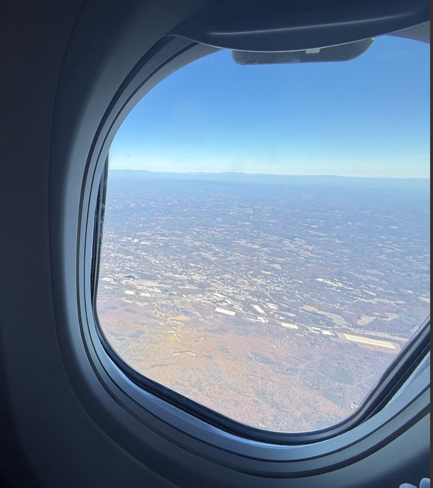
Nice shot outside of King's Mountain (sometimes it's a fun challenge trying to match up where plane window pics were taken).

November 4, 2025 at 2:58 PM
Nice shot outside of King's Mountain (sometimes it's a fun challenge trying to match up where plane window pics were taken).
There's also an update from @dropsitenews.com's Younis Tirawi with images from the site after the IDF left showing damage and what appears to be the flag of Israel burned into the side of one of the water treatment plant buildings.
Link: x.com/ytirawi/stat...
Link: x.com/ytirawi/stat...


October 17, 2025 at 4:50 PM
There's also an update from @dropsitenews.com's Younis Tirawi with images from the site after the IDF left showing damage and what appears to be the flag of Israel burned into the side of one of the water treatment plant buildings.
Link: x.com/ytirawi/stat...
Link: x.com/ytirawi/stat...
From @alexanderspoeri.bsky.social on X — the German government has responded to questions about the Shiekh Ejleen Water Treatment Plant being torched by the IDF given it was financed with German taxpayer money.
They've asked the IDF to clarify what happened.
Link to post: x.com/alexanderspo...
They've asked the IDF to clarify what happened.
Link to post: x.com/alexanderspo...

October 17, 2025 at 2:37 PM
From @alexanderspoeri.bsky.social on X — the German government has responded to questions about the Shiekh Ejleen Water Treatment Plant being torched by the IDF given it was financed with German taxpayer money.
They've asked the IDF to clarify what happened.
Link to post: x.com/alexanderspo...
They've asked the IDF to clarify what happened.
Link to post: x.com/alexanderspo...
The road is helpful for the geolocation! Looks like the mountain's at 26.854593, 87.591046: www.google.com/maps/place/2...


October 14, 2025 at 2:18 PM
The road is helpful for the geolocation! Looks like the mountain's at 26.854593, 87.591046: www.google.com/maps/place/2...
Looks like the berms are mostly intact but October 11 SkySat shows the now-empty Netzarim GHF site. The vehicles of folks who I'm guessing are returning north along Salah al-Deen Road are also visible.


October 13, 2025 at 4:16 PM
Looks like the berms are mostly intact but October 11 SkySat shows the now-empty Netzarim GHF site. The vehicles of folks who I'm guessing are returning north along Salah al-Deen Road are also visible.
Reporting from @dropsitenews.com's Younis Tirawi found photos of IDF soldiers celebrating in front of the Waste Water Treatment Plant fire before withdrawing: www.dropsitenews.com/p/israel-idf...
The director of Gaza's water utility told Drop Site the fire could setback reconstruction by years.
The director of Gaza's water utility told Drop Site the fire could setback reconstruction by years.


October 13, 2025 at 3:46 PM
Reporting from @dropsitenews.com's Younis Tirawi found photos of IDF soldiers celebrating in front of the Waste Water Treatment Plant fire before withdrawing: www.dropsitenews.com/p/israel-idf...
The director of Gaza's water utility told Drop Site the fire could setback reconstruction by years.
The director of Gaza's water utility told Drop Site the fire could setback reconstruction by years.
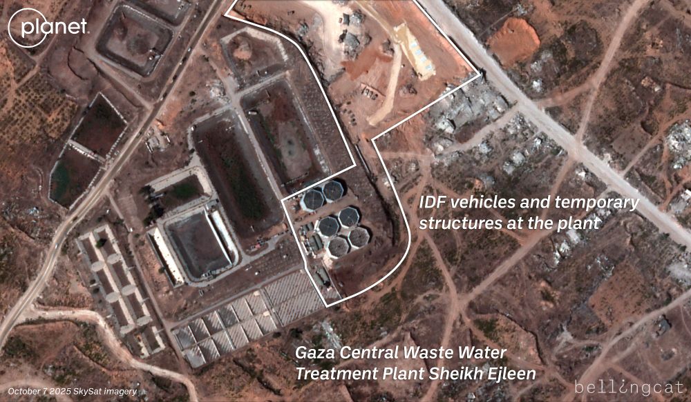
October 11 SkySat imagery from @planet.com shows a column of smoke rising from the Sheikh Ejleen Waste Water Treatment Plant after the IDF withdrew from the base they established at the plant.
SkySat imagery from October 7 shows IDF vehicles and temporary structures set up inside the plant.
SkySat imagery from October 7 shows IDF vehicles and temporary structures set up inside the plant.

October 13, 2025 at 3:40 PM
October 11 SkySat imagery from @planet.com shows a column of smoke rising from the Sheikh Ejleen Waste Water Treatment Plant after the IDF withdrew from the base they established at the plant.
SkySat imagery from October 7 shows IDF vehicles and temporary structures set up inside the plant.
SkySat imagery from October 7 shows IDF vehicles and temporary structures set up inside the plant.
Should note that some of the mound was already paved pre-war — though the area was mostly orchards. There was also a café on top that people frequented, as pointed out by @michaeldpress.bsky.social and SkyNews: bsky.app/profile/mich...
Two years later, there's been an immense amount of destruction.
Two years later, there's been an immense amount of destruction.


October 10, 2025 at 6:58 PM
Should note that some of the mound was already paved pre-war — though the area was mostly orchards. There was also a café on top that people frequented, as pointed out by @michaeldpress.bsky.social and SkyNews: bsky.app/profile/mich...
Two years later, there's been an immense amount of destruction.
Two years later, there's been an immense amount of destruction.
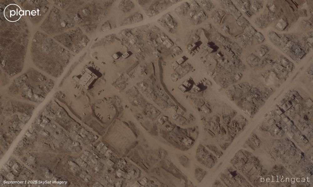
After conducting extensive earthworks on top of the archeological mound Tell Ali Muntar, it appears in more recent @planet.com SkySat imagery from October 7 that the IDF has since paved the top of the mound.
The visible black area is similar to what we've seen when pavement has been used elsewhere.
The visible black area is similar to what we've seen when pavement has been used elsewhere.


October 10, 2025 at 6:35 PM
After conducting extensive earthworks on top of the archeological mound Tell Ali Muntar, it appears in more recent @planet.com SkySat imagery from October 7 that the IDF has since paved the top of the mound.
The visible black area is similar to what we've seen when pavement has been used elsewhere.
The visible black area is similar to what we've seen when pavement has been used elsewhere.
Latest PlanetScope capture over Netzarim was around noon, so not sure if it'd started getting dismantled by then. This is what it looks like compared with the October 4 PlanetScope.
Possible we'll see them destroy the berms around the site like the last time they withdrew from most of the corridor.
Possible we'll see them destroy the berms around the site like the last time they withdrew from most of the corridor.


October 10, 2025 at 6:21 PM
Latest PlanetScope capture over Netzarim was around noon, so not sure if it'd started getting dismantled by then. This is what it looks like compared with the October 4 PlanetScope.
Possible we'll see them destroy the berms around the site like the last time they withdrew from most of the corridor.
Possible we'll see them destroy the berms around the site like the last time they withdrew from most of the corridor.
These towers surround Gaza's Roman Cemetery — an ancient intact burial site with 125 tombs that was discovered in 2022. @premiereurgenceint.bsky.social worked on the site before the war: www.theartnewspaper.com/2023/07/26/r...
Can see the site in a video from 2023: www.youtube.com/watch?v=VStQ...
Can see the site in a video from 2023: www.youtube.com/watch?v=VStQ...

September 29, 2025 at 2:02 PM
These towers surround Gaza's Roman Cemetery — an ancient intact burial site with 125 tombs that was discovered in 2022. @premiereurgenceint.bsky.social worked on the site before the war: www.theartnewspaper.com/2023/07/26/r...
Can see the site in a video from 2023: www.youtube.com/watch?v=VStQ...
Can see the site in a video from 2023: www.youtube.com/watch?v=VStQ...
Video shared by Younis Tirawi on Twitter and geolocated by @fdov21.bsky.social shows the Al-Furqan Primary School being blown up.
This would have happened today or yesterday after the most recent SkySat image was taken.
CC: @benedictgarman.com
Link: x.com/ytirawi/stat...
This would have happened today or yesterday after the most recent SkySat image was taken.
CC: @benedictgarman.com
Link: x.com/ytirawi/stat...
September 3, 2025 at 8:46 PM
Video shared by Younis Tirawi on Twitter and geolocated by @fdov21.bsky.social shows the Al-Furqan Primary School being blown up.
This would have happened today or yesterday after the most recent SkySat image was taken.
CC: @benedictgarman.com
Link: x.com/ytirawi/stat...
This would have happened today or yesterday after the most recent SkySat image was taken.
CC: @benedictgarman.com
Link: x.com/ytirawi/stat...
Appears the same National Guard UH-72 Lakota 11-72212 that dusted protesters in downtown D.C. in 2020 (noted by @giancarlofiorella.bsky.social) is back in D.C.'s skies again. Not clear for what purpose, though did a similar route on Sept. 1.
FlightRadar24 link: www.flightradar24.com/data/aircraf...
FlightRadar24 link: www.flightradar24.com/data/aircraf...


September 3, 2025 at 7:00 PM
Appears the same National Guard UH-72 Lakota 11-72212 that dusted protesters in downtown D.C. in 2020 (noted by @giancarlofiorella.bsky.social) is back in D.C.'s skies again. Not clear for what purpose, though did a similar route on Sept. 1.
FlightRadar24 link: www.flightradar24.com/data/aircraf...
FlightRadar24 link: www.flightradar24.com/data/aircraf...
On-the-ground view of an IDF forward operating base located at the Al-Furqan Primary School. SkySat imagery from @planet.com shows the IDF first appeared in the vicinity of the school mid-August. Still there as of September 1 imagery.

September 3, 2025 at 6:17 PM
On-the-ground view of an IDF forward operating base located at the Al-Furqan Primary School. SkySat imagery from @planet.com shows the IDF first appeared in the vicinity of the school mid-August. Still there as of September 1 imagery.
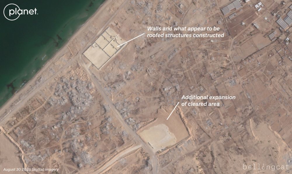
Updated @planet.com SkySat imagery in southern Gaza just north of Swedish Village and the "SDS1" site shows new infrastructure built by the IDF in August. It's unclear what the purpose is, though one large gravel rectangle now has walls and what appear to be 4 small roofed structures.


September 2, 2025 at 9:05 PM
Updated @planet.com SkySat imagery in southern Gaza just north of Swedish Village and the "SDS1" site shows new infrastructure built by the IDF in August. It's unclear what the purpose is, though one large gravel rectangle now has walls and what appear to be 4 small roofed structures.
Saw the same ads on posters put up along Georgia Avenue in Petworth.

September 2, 2025 at 5:36 PM
Saw the same ads on posters put up along Georgia Avenue in Petworth.
There's been an incredible amount of destruction in Khan Yunis east of Nasser Hospital in the past 3 months, so it makes sense it was being filmed on a livestream as it was happening.
Compare April and August @planet.com imagery and a large swath of destruction going north to south is visible.
Compare April and August @planet.com imagery and a large swath of destruction going north to south is visible.


August 29, 2025 at 3:12 PM
There's been an incredible amount of destruction in Khan Yunis east of Nasser Hospital in the past 3 months, so it makes sense it was being filmed on a livestream as it was happening.
Compare April and August @planet.com imagery and a large swath of destruction going north to south is visible.
Compare April and August @planet.com imagery and a large swath of destruction going north to south is visible.
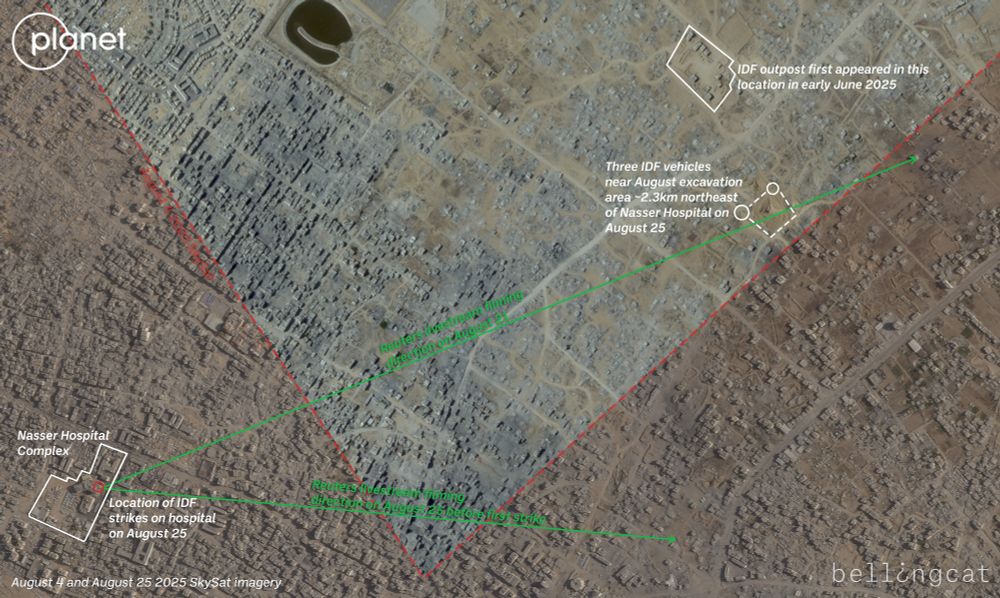
The Reuters livestream was pointing east on August 25 when the hospital's eastern stairwell was hit by three IDF strikes (a fourth strike hit the northern stairwell).
The fact the livestream could see the excavation area makes it a possible point from where the IDF fired at the hospital from.
The fact the livestream could see the excavation area makes it a possible point from where the IDF fired at the hospital from.
August 29, 2025 at 2:10 PM
The Reuters livestream was pointing east on August 25 when the hospital's eastern stairwell was hit by three IDF strikes (a fourth strike hit the northern stairwell).
The fact the livestream could see the excavation area makes it a possible point from where the IDF fired at the hospital from.
The fact the livestream could see the excavation area makes it a possible point from where the IDF fired at the hospital from.
The excavation is visible on @planet.com SkySat satellite imagery from the August 25, taken about 7 hours after Nasser Hospital was hit. You can see three IDF vehicles are present there, about 2.3km from the hospital. The nearby IDF outpost is also visible (as pointed out by CNN and BBC).

August 29, 2025 at 1:55 PM
The excavation is visible on @planet.com SkySat satellite imagery from the August 25, taken about 7 hours after Nasser Hospital was hit. You can see three IDF vehicles are present there, about 2.3km from the hospital. The nearby IDF outpost is also visible (as pointed out by CNN and BBC).
Something to note on the Nasser Hospital attack — there's a direct line of sight to the Reuters livestream position to a large IDF excavation northeast of the hospital. The livestream had even filmed what appear to be two IDF tanks moving in the area on Aug 21: www.youtube.com/live/uN78d9M...
August 29, 2025 at 1:51 PM
Something to note on the Nasser Hospital attack — there's a direct line of sight to the Reuters livestream position to a large IDF excavation northeast of the hospital. The livestream had even filmed what appear to be two IDF tanks moving in the area on Aug 21: www.youtube.com/live/uN78d9M...
Just for awareness of the area around Nasser Hospital and central/northern Khan Yunis, there's some partial @planet.com SkySat from yesterday showing an IDF outpost about 2.5km NE of the hospital and the heavy destruction that's taken place since June.
Most recent SkySat over Nasser was August 4.
Most recent SkySat over Nasser was August 4.

August 25, 2025 at 6:27 PM
Just for awareness of the area around Nasser Hospital and central/northern Khan Yunis, there's some partial @planet.com SkySat from yesterday showing an IDF outpost about 2.5km NE of the hospital and the heavy destruction that's taken place since June.
Most recent SkySat over Nasser was August 4.
Most recent SkySat over Nasser was August 4.
Another broadcast from Al Ghad TV showed the double tap as it happened. In the footage, a man holds up camera gear (possibly Al-Masri's) and a man in red (who Reuters says is Khaled) films with his phone. Reuters shared part of what Khaled filmed with his phone here:
www.youtube.com/watch?v=C_pg...
www.youtube.com/watch?v=C_pg...


August 25, 2025 at 4:09 PM
Another broadcast from Al Ghad TV showed the double tap as it happened. In the footage, a man holds up camera gear (possibly Al-Masri's) and a man in red (who Reuters says is Khaled) films with his phone. Reuters shared part of what Khaled filmed with his phone here:
www.youtube.com/watch?v=C_pg...
www.youtube.com/watch?v=C_pg...
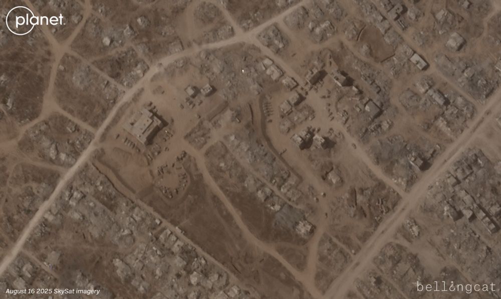
It appears the IDF are conducting more earthworks on top of Tell Ali Muntar, potentially further damaging a Bronze Age-era archeological hill in what little remains of Gaza City's Shejaiya neighborhood.
Michael Press shared some of the history of the site here:
bsky.app/profile/mich...
Michael Press shared some of the history of the site here:
bsky.app/profile/mich...


August 18, 2025 at 8:52 PM
It appears the IDF are conducting more earthworks on top of Tell Ali Muntar, potentially further damaging a Bronze Age-era archeological hill in what little remains of Gaza City's Shejaiya neighborhood.
Michael Press shared some of the history of the site here:
bsky.app/profile/mich...
Michael Press shared some of the history of the site here:
bsky.app/profile/mich...
It's important that @itvnews.bsky.social was able to film the devastation in Gaza, but I'd note the buildings identified as the Turkish Hospital in their video at the 1:19 timestamp is incorrect.
The hospital is nearby at 31.4778, 34.4162. The buildings they highlight are at 31.4769, 34.4081.
The hospital is nearby at 31.4778, 34.4162. The buildings they highlight are at 31.4769, 34.4081.

August 8, 2025 at 1:47 PM
It's important that @itvnews.bsky.social was able to film the devastation in Gaza, but I'd note the buildings identified as the Turkish Hospital in their video at the 1:19 timestamp is incorrect.
The hospital is nearby at 31.4778, 34.4162. The buildings they highlight are at 31.4769, 34.4081.
The hospital is nearby at 31.4778, 34.4162. The buildings they highlight are at 31.4769, 34.4081.