


Geology of the Tour de France
@geotdf.bsky.social
At @GeoTdF.bsky.social we answer your questions on landscapes and geology cycling races | see Geo-Sports.org for more information!
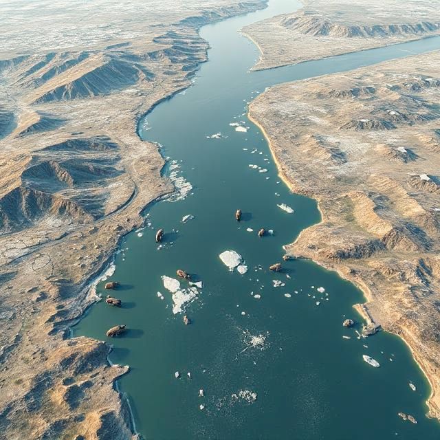
And humans have used the dry North Sea to migrate from France to England and back during the last 800.000 years, depending on the climate state. And when there was enough ice, they could also walk to Ireland! No ferry needed. Or cycle, if they had invented the wheel.
July 7, 2025 at 2:04 PM
And humans have used the dry North Sea to migrate from France to England and back during the last 800.000 years, depending on the climate state. And when there was enough ice, they could also walk to Ireland! No ferry needed. Or cycle, if they had invented the wheel.
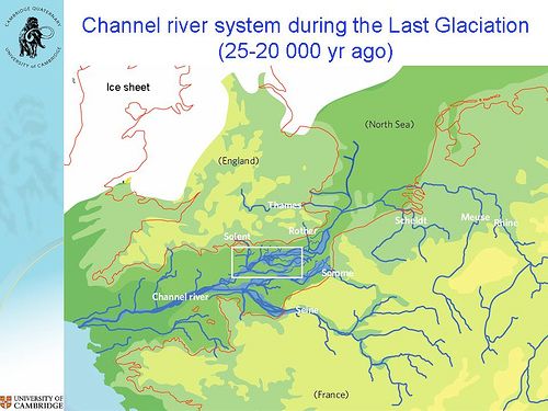
Well, dry, it was occupied by a tundra and a large river, that combined the Rhine, the Meuse, the Scheldt, and the Thames.
These flowed towards the Bay of Biscay. Mammoths roamed the banks, and the vast tundras south of the ice caps of Scandinavia.
These flowed towards the Bay of Biscay. Mammoths roamed the banks, and the vast tundras south of the ice caps of Scandinavia.
July 7, 2025 at 2:04 PM
Well, dry, it was occupied by a tundra and a large river, that combined the Rhine, the Meuse, the Scheldt, and the Thames.
These flowed towards the Bay of Biscay. Mammoths roamed the banks, and the vast tundras south of the ice caps of Scandinavia.
These flowed towards the Bay of Biscay. Mammoths roamed the banks, and the vast tundras south of the ice caps of Scandinavia.
OK, so we decided not do skip a GeoTdF year, but this stage is so boring that it's begging for some geo-info!
We're riding along the North Sea coast towards Dunquerque. But even as recent as 20.000 years ago, there was no coast here! During the last ice age, the Channel was dry!
We're riding along the North Sea coast towards Dunquerque. But even as recent as 20.000 years ago, there was no coast here! During the last ice age, the Channel was dry!
July 7, 2025 at 2:04 PM
OK, so we decided not do skip a GeoTdF year, but this stage is so boring that it's begging for some geo-info!
We're riding along the North Sea coast towards Dunquerque. But even as recent as 20.000 years ago, there was no coast here! During the last ice age, the Channel was dry!
We're riding along the North Sea coast towards Dunquerque. But even as recent as 20.000 years ago, there was no coast here! During the last ice age, the Channel was dry!
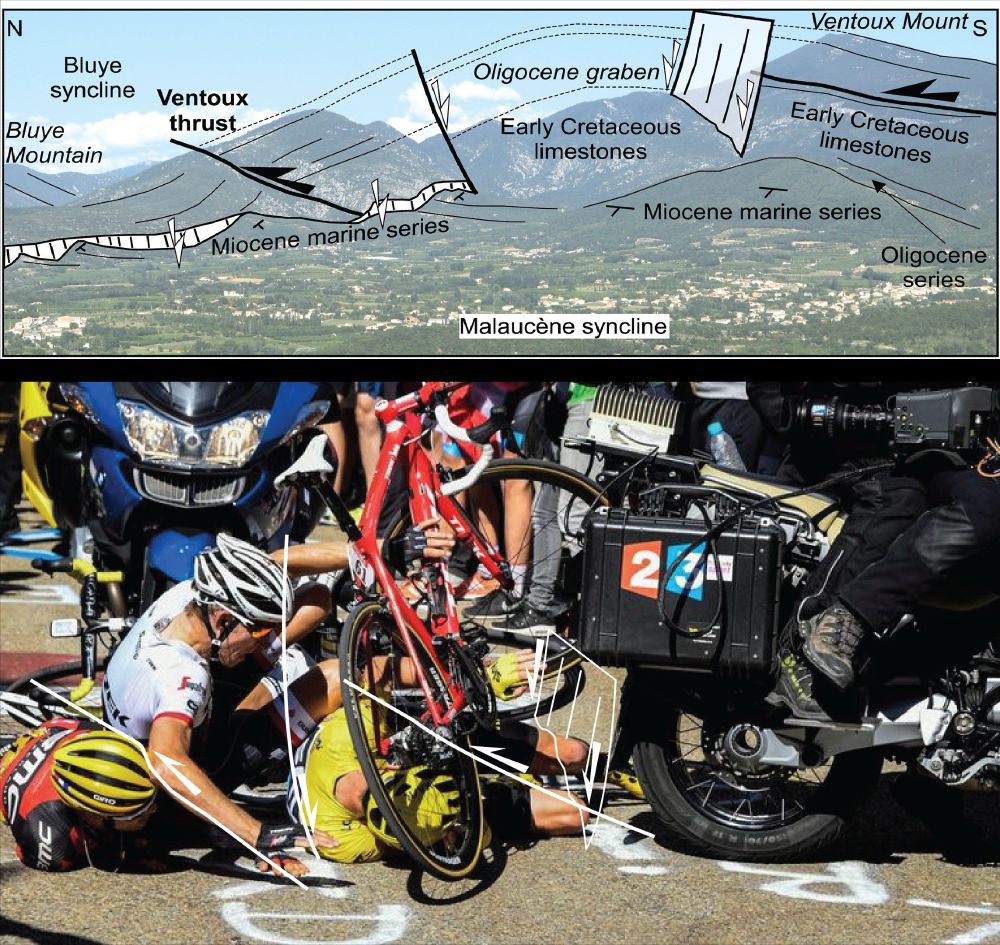
OK, so we won't do a detailed GeoTdF this year, but we couldn't help ourselves...the geology of the Ventoux is quite clearly correlated with scenes during the climbs. For example, the famous 2016 incident that left Chris Froome running up with a broken bike - clearly geologically pre-determined.
June 26, 2025 at 7:23 AM
OK, so we won't do a detailed GeoTdF this year, but we couldn't help ourselves...the geology of the Ventoux is quite clearly correlated with scenes during the climbs. For example, the famous 2016 incident that left Chris Froome running up with a broken bike - clearly geologically pre-determined.
Eastern Albania is more mountainous, and consists of pieces of the former Greater Adria continent, pushed and piled up. And at the top lies one of the best preserved pieces of oceanic crust on land ('ophiolites') in the world: the Mirdita Ophiolite. But we'll stay west, and head for Italy next!

May 10, 2025 at 12:57 PM
Eastern Albania is more mountainous, and consists of pieces of the former Greater Adria continent, pushed and piled up. And at the top lies one of the best preserved pieces of oceanic crust on land ('ophiolites') in the world: the Mirdita Ophiolite. But we'll stay west, and head for Italy next!
This platform continues to the Greek Islands of Paxos, Lefkas, Kefallonia and Zakynthos. To the North and East of this platform was a deeper basin in which thin-layered limestones formed. You will see those, folded up and broken,in Albania. And later in Umbria and Marche, in northern Italy!

May 10, 2025 at 12:57 PM
This platform continues to the Greek Islands of Paxos, Lefkas, Kefallonia and Zakynthos. To the North and East of this platform was a deeper basin in which thin-layered limestones formed. You will see those, folded up and broken,in Albania. And later in Umbria and Marche, in northern Italy!
The last intact remnant of Adria lies below the Adriatic Sea, and on the Karaburun Peninsula in southwest Albania, and in Puglia, where the Giro will ride its first meters in Italy this year. These intact remnants are shallow marine limestones of the Apulian Platform in the south.

May 10, 2025 at 12:57 PM
The last intact remnant of Adria lies below the Adriatic Sea, and on the Karaburun Peninsula in southwest Albania, and in Puglia, where the Giro will ride its first meters in Italy this year. These intact remnants are shallow marine limestones of the Apulian Platform in the south.
Greater Adria was pulled down into subduction zones: both to the west, below Italy, and east, below Albania (and Greece and the Balkan). The sedimentary rocks that formed at the margins of Adria were scraped off and pushed up, making the Apennines and the Albanides/Hellenides/Dinarides

May 10, 2025 at 12:57 PM
Greater Adria was pulled down into subduction zones: both to the west, below Italy, and east, below Albania (and Greece and the Balkan). The sedimentary rocks that formed at the margins of Adria were scraped off and pushed up, making the Apennines and the Albanides/Hellenides/Dinarides
The Giro d'Italia started in Albania, but the riders who are used to Italy will feel geologically right at home! Just like the Apennines, the Albanides (and the Dinarides to the North and Hellenides to the South) are made of rocks that were once part of the continent (Greater) Adria!

May 10, 2025 at 12:57 PM
The Giro d'Italia started in Albania, but the riders who are used to Italy will feel geologically right at home! Just like the Apennines, the Albanides (and the Dinarides to the North and Hellenides to the South) are made of rocks that were once part of the continent (Greater) Adria!
For those of you who are Tired Of All This Shit, we bring you:
The relationship between volcanism and the invention of the bicycle!
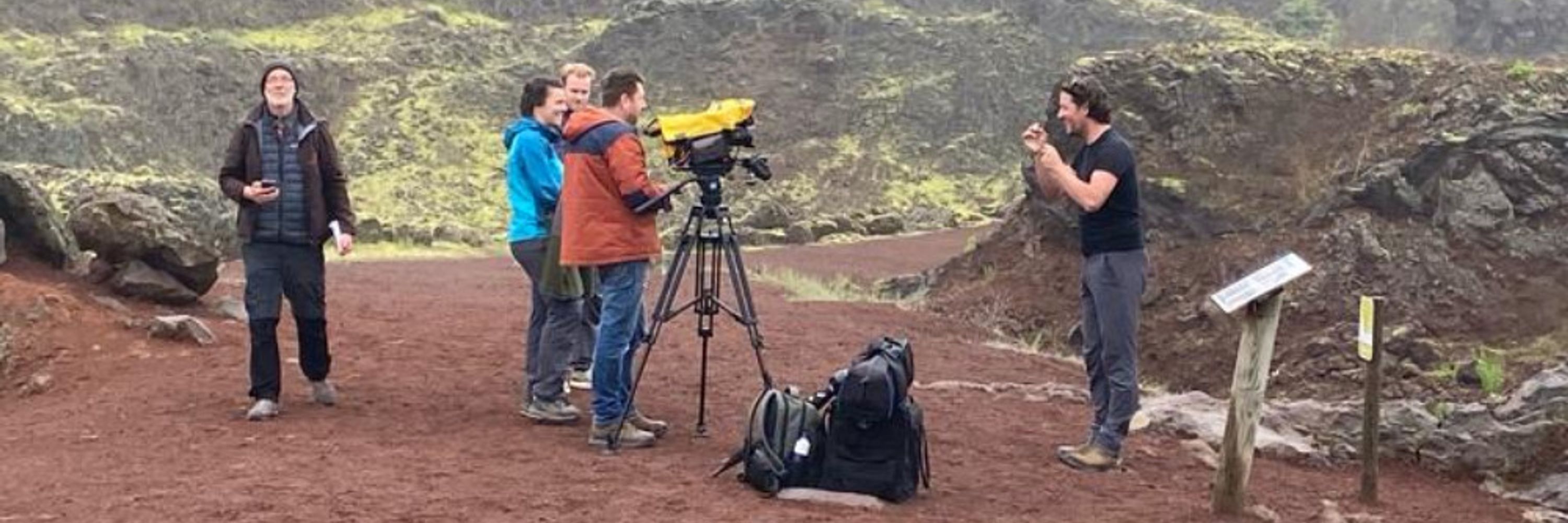
We made this clip, with @vanhinsbergen.bsky.social, for last year's Tour de France stage over the Cantal Volcano, and its highest remaining peak, Puy Mary ❤️🤠
The relationship between volcanism and the invention of the bicycle!
We made this clip, with @vanhinsbergen.bsky.social, for last year's Tour de France stage over the Cantal Volcano, and its highest remaining peak, Puy Mary ❤️🤠
March 20, 2025 at 7:04 AM
For those of you who are Tired Of All This Shit, we bring you:
The relationship between volcanism and the invention of the bicycle!
We made this clip, with @vanhinsbergen.bsky.social, for last year's Tour de France stage over the Cantal Volcano, and its highest remaining peak, Puy Mary ❤️🤠
The relationship between volcanism and the invention of the bicycle!
We made this clip, with @vanhinsbergen.bsky.social, for last year's Tour de France stage over the Cantal Volcano, and its highest remaining peak, Puy Mary ❤️🤠
That continental edge was pushed below Corsica, 20 million years ago, and pulled back to the surface in the last 10 million years, when the Tyrrhenian Sea basin was formed.
The limestones became marbles, the marbles became gravel, and now it’s the peloton that is under high pressure! Enjoy!
The limestones became marbles, the marbles became gravel, and now it’s the peloton that is under high pressure! Enjoy!

March 8, 2025 at 7:57 AM
That continental edge was pushed below Corsica, 20 million years ago, and pulled back to the surface in the last 10 million years, when the Tyrrhenian Sea basin was formed.
The limestones became marbles, the marbles became gravel, and now it’s the peloton that is under high pressure! Enjoy!
The limestones became marbles, the marbles became gravel, and now it’s the peloton that is under high pressure! Enjoy!
Marble is a metamorphic rock: it was originally a limestone that was buried to 25 km depth or so, and heated up to a few hundred degrees. In the case of Tuscany, these limestones formed as reefs on the edge of the Adria continent.

March 8, 2025 at 7:57 AM
Marble is a metamorphic rock: it was originally a limestone that was buried to 25 km depth or so, and heated up to a few hundred degrees. In the case of Tuscany, these limestones formed as reefs on the edge of the Adria continent.
Strade Bianche day! The famous white gravel roads of Tuscany promise another epic battle on the bike. But where do the white gravels come from?
Tuscany’s subsurface consists of marble: bright white crystals of calcium carbonate. These are famously mined in western Tuscany, in the Carrara quarries.
Tuscany’s subsurface consists of marble: bright white crystals of calcium carbonate. These are famously mined in western Tuscany, in the Carrara quarries.

March 8, 2025 at 7:57 AM
Strade Bianche day! The famous white gravel roads of Tuscany promise another epic battle on the bike. But where do the white gravels come from?
Tuscany’s subsurface consists of marble: bright white crystals of calcium carbonate. These are famously mined in western Tuscany, in the Carrara quarries.
Tuscany’s subsurface consists of marble: bright white crystals of calcium carbonate. These are famously mined in western Tuscany, in the Carrara quarries.
The most spectacular rocks of the Semail Ophiolite are so-called 'pillow lavas'. These structures form when lava erupts below sea level: the lava quickly cools from the outside, but keeps flowing on the inside. Cut them, and you get a pile of pillows. Good for a rest day!

February 7, 2025 at 5:46 PM
The most spectacular rocks of the Semail Ophiolite are so-called 'pillow lavas'. These structures form when lava erupts below sea level: the lava quickly cools from the outside, but keeps flowing on the inside. Cut them, and you get a pile of pillows. Good for a rest day!
In Oman, the Arabian continent went down into a subduction zone below oceanic crust, 80 million years ago, and scooped up the 'Semail' ophiolite. Along the race you see the magmatic rocks that formed at a spreading ridge, and rocks of the Earth's mantle that were below the ridge!


February 7, 2025 at 5:46 PM
In Oman, the Arabian continent went down into a subduction zone below oceanic crust, 80 million years ago, and scooped up the 'Semail' ophiolite. Along the race you see the magmatic rocks that formed at a spreading ridge, and rocks of the Earth's mantle that were below the ridge!
An ophiolite is a piece of oceanic crust that is exposed above sea level. Oceanic crust forms at spreading ridges, and is normally many kilometers below sea level. But when subduction zones form in oceans, such as in the Philippines, oceanic crust may be uplifted and emerge.

February 7, 2025 at 5:46 PM
An ophiolite is a piece of oceanic crust that is exposed above sea level. Oceanic crust forms at spreading ridges, and is normally many kilometers below sea level. But when subduction zones form in oceans, such as in the Philippines, oceanic crust may be uplifted and emerge.
Geology of the Tour of Oman! - The peloton may think that they're riding through desert mountains this week, but for a geologist, they're riding through the deep ocean, and the mantle below that ocean! Oman is one of the favorite geo-destinations: the world's most beautiful 'ophiolite'. #Geoscience

February 7, 2025 at 5:46 PM
Geology of the Tour of Oman! - The peloton may think that they're riding through desert mountains this week, but for a geologist, they're riding through the deep ocean, and the mantle below that ocean! Oman is one of the favorite geo-destinations: the world's most beautiful 'ophiolite'. #Geoscience
NW of Alula, the peloton will see dormant volcanoes of the Harat Uwayrid volcanic field of only 8-0.3 million years old. These are thought to relate to ‘plume’ volcanism, with calm basalt lava flows like on the Canary Islands! Familiar ground for those who trained on the #Teide !
January 28, 2025 at 7:55 AM
NW of Alula, the peloton will see dormant volcanoes of the Harat Uwayrid volcanic field of only 8-0.3 million years old. These are thought to relate to ‘plume’ volcanism, with calm basalt lava flows like on the Canary Islands! Familiar ground for those who trained on the #Teide !
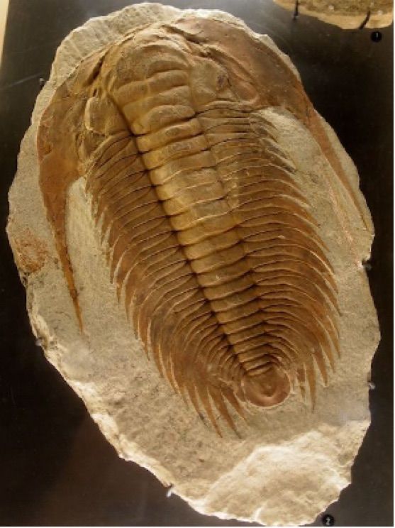
Sandstones of the next-younger Saq Formation is an Arabian lifesaver: these rocks are porous, and serve as the main aquifer (that is, a groundwater-bearing layer) of NW Arabia. These sandstones are rich in trace fossils: tracks in the sand made by ‘trilobites’that roamed the Cambrian sea floor!
January 28, 2025 at 7:55 AM
Sandstones of the next-younger Saq Formation is an Arabian lifesaver: these rocks are porous, and serve as the main aquifer (that is, a groundwater-bearing layer) of NW Arabia. These sandstones are rich in trace fossils: tracks in the sand made by ‘trilobites’that roamed the Cambrian sea floor!
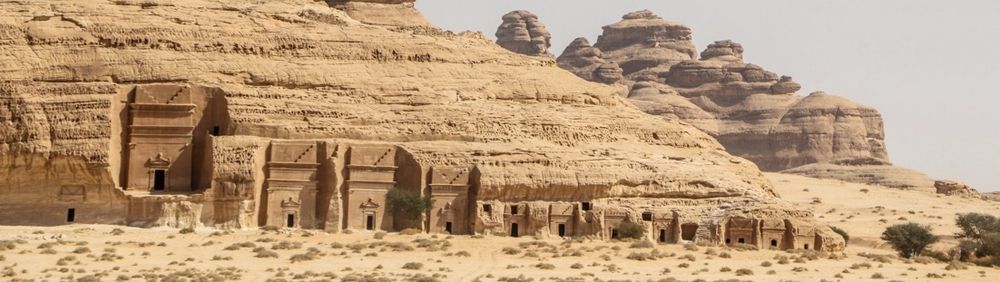
The Quweira Sandstonesare particularly resistant. These were were used for the famous settlements of Madain Saleh, not far from AlUla. This city was built in the 2nd century CE by the Nabateans, and has beautifully been preserved in the durable, hard rocks.
January 28, 2025 at 7:55 AM
The Quweira Sandstonesare particularly resistant. These were were used for the famous settlements of Madain Saleh, not far from AlUla. This city was built in the 2nd century CE by the Nabateans, and has beautifully been preserved in the durable, hard rocks.
The pro-cycling peloton is racing the Al'Ula Tour in Saudi Arabia this week, territory of spectacular cliffs of sandstones, deserts, and young volcanoes.
The cliffs around AlUla formed in shallow seas, ~500 million years ago, but to the South Polar, as part of the supercontinent 'Gondwana'.
The cliffs around AlUla formed in shallow seas, ~500 million years ago, but to the South Polar, as part of the supercontinent 'Gondwana'.

January 28, 2025 at 7:55 AM
The pro-cycling peloton is racing the Al'Ula Tour in Saudi Arabia this week, territory of spectacular cliffs of sandstones, deserts, and young volcanoes.
The cliffs around AlUla formed in shallow seas, ~500 million years ago, but to the South Polar, as part of the supercontinent 'Gondwana'.
The cliffs around AlUla formed in shallow seas, ~500 million years ago, but to the South Polar, as part of the supercontinent 'Gondwana'.
This causes earthquakes - mostly small ones, but in 1954 with a magnitude 5.4.
The faults that push up Mt Lofty slip on average half a mm per year. And with this ongoing uplift, the Tour Down Under gets a little harder every year 😃!
The faults that push up Mt Lofty slip on average half a mm per year. And with this ongoing uplift, the Tour Down Under gets a little harder every year 😃!
January 20, 2025 at 7:11 AM
This causes earthquakes - mostly small ones, but in 1954 with a magnitude 5.4.
The faults that push up Mt Lofty slip on average half a mm per year. And with this ongoing uplift, the Tour Down Under gets a little harder every year 😃!
The faults that push up Mt Lofty slip on average half a mm per year. And with this ongoing uplift, the Tour Down Under gets a little harder every year 😃!
But the ancient faults that cut these rocks were reactivated because the Australian plate is being squeezed between the Eurasia and the Pacific, and also interacting with India and Australia.
The squeezing popped up the Flinders ranges, and the epic Mount Lofty, and this process continues today.
The squeezing popped up the Flinders ranges, and the epic Mount Lofty, and this process continues today.

January 20, 2025 at 7:11 AM
But the ancient faults that cut these rocks were reactivated because the Australian plate is being squeezed between the Eurasia and the Pacific, and also interacting with India and Australia.
The squeezing popped up the Flinders ranges, and the epic Mount Lofty, and this process continues today.
The squeezing popped up the Flinders ranges, and the epic Mount Lofty, and this process continues today.
the Adelaide region forms a rare exception: it's shaking! Australia consists mostly of rocks of billions of years old, which formed when ancient continents collided and long-forgotten mountain belts formed. The rocks around Adelaide are up to 900 million years old, when life was only microbial.

January 20, 2025 at 7:11 AM
the Adelaide region forms a rare exception: it's shaking! Australia consists mostly of rocks of billions of years old, which formed when ancient continents collided and long-forgotten mountain belts formed. The rocks around Adelaide are up to 900 million years old, when life was only microbial.
And off we go with the 2025 geo-road cycling season 🥳🚴♀️🤠! The Tour Down Under brings the peloton to Adalaide, in the middle of the Australian plate. If you were afraid of earthquakes, you'd think this would be a safe place, as most earthquakes occur at plate boundaries. But you'd be wrong 😑.

January 20, 2025 at 7:11 AM
And off we go with the 2025 geo-road cycling season 🥳🚴♀️🤠! The Tour Down Under brings the peloton to Adalaide, in the middle of the Australian plate. If you were afraid of earthquakes, you'd think this would be a safe place, as most earthquakes occur at plate boundaries. But you'd be wrong 😑.