


Flood Information Service Ireland
@floodingireland.bsky.social
Flooding Ireland is a flood advice and information service covering Irelands Rivers and Coasts
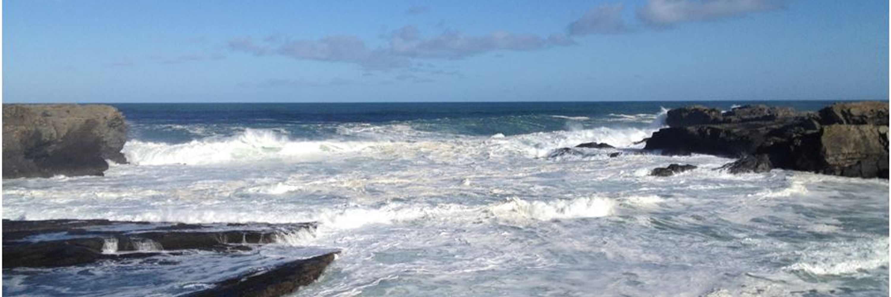
#StormEowyn High seas off the west coast tomorrow morning from the storm. Stay away from coasts during this event. Stay high and stay dry. Do not put yourself or an emergency worker in harms way

January 23, 2025 at 6:52 PM
#StormEowyn High seas off the west coast tomorrow morning from the storm. Stay away from coasts during this event. Stay high and stay dry. Do not put yourself or an emergency worker in harms way
#StormÉowyn The storm centre is approx 600Km off the SW coast heading in our direction and still deepening.

January 23, 2025 at 6:15 PM
#StormÉowyn The storm centre is approx 600Km off the SW coast heading in our direction and still deepening.
#StormÉowyn there is potential for a severe storm early Friday morning. This may have widespread impacts. We will update as we watch developments.

January 21, 2025 at 3:16 PM
#StormÉowyn there is potential for a severe storm early Friday morning. This may have widespread impacts. We will update as we watch developments.
#StormDarragh is now off the NW coast. As it moves NE very strong winds will ramp up later this evening. There is a red warning in place for wind from CE to DL later & WW on the E coast early Sat. The country is under orange warning for wind. Don't make unnecessary journeys...

December 6, 2024 at 5:39 PM
#StormDarragh is now off the NW coast. As it moves NE very strong winds will ramp up later this evening. There is a red warning in place for wind from CE to DL later & WW on the E coast early Sat. The country is under orange warning for wind. Don't make unnecessary journeys...
#StormDarragh Red warnings have been issued for Storm Darragh tonight from Clare, Galway Mayo, Sligo Leitrim and Donegal. There is a risk of storm over-topping and storm damage with very strong winds.

December 6, 2024 at 10:37 AM
#StormDarragh Red warnings have been issued for Storm Darragh tonight from Clare, Galway Mayo, Sligo Leitrim and Donegal. There is a risk of storm over-topping and storm damage with very strong winds.
#StormDarragh is set to hit Irish coasts Friday night with onshore winds and low pressure storm surge. West and SW coasts are the main areas at risk. There is a risk of coastal flooding and storm damage/wave over-topping as a result.

December 5, 2024 at 2:28 PM
#StormDarragh is set to hit Irish coasts Friday night with onshore winds and low pressure storm surge. West and SW coasts are the main areas at risk. There is a risk of coastal flooding and storm damage/wave over-topping as a result.
#StormBert rainfall yesterday until 0600 this morning. This rainfall is now making its way through the rivers system to the sea completing the hydrological cycle.

November 24, 2024 at 9:12 AM
#StormBert rainfall yesterday until 0600 this morning. This rainfall is now making its way through the rivers system to the sea completing the hydrological cycle.
#StormBert current water levels on the OPW national gauge network. Quite a few gauges between median annual maximum and annual maximum and a few exceeding their previous annual maximum. Exceptional flow of water in quite a few places.

November 23, 2024 at 2:24 PM
#StormBert current water levels on the OPW national gauge network. Quite a few gauges between median annual maximum and annual maximum and a few exceeding their previous annual maximum. Exceptional flow of water in quite a few places.
#StormBert you can see the front associated with the storm arriving with the increase in temperatures in the SW and W. After the temperature increase the rain will follow.

November 22, 2024 at 8:11 PM
#StormBert you can see the front associated with the storm arriving with the increase in temperatures in the SW and W. After the temperature increase the rain will follow.
#StormBert river levels before the rainfall over the west including Galway under red warning and Mayo and Sligo under orange warning.

November 22, 2024 at 6:11 PM
#StormBert river levels before the rainfall over the west including Galway under red warning and Mayo and Sligo under orange warning.
#StormBert river levels before the rainfall over the southwest including Cork under red warning and Kerry and Waterford under orange warning.

November 22, 2024 at 6:08 PM
#StormBert river levels before the rainfall over the southwest including Cork under red warning and Kerry and Waterford under orange warning.
#StormBert high resolution model showing very high rainfall totals tonight. Amounts >50mm possible in a short period with more over high ground. There is a risk of severe flooding as a result. The main risk areas are over C & GY & a likelihood of more over the next few days.

November 22, 2024 at 5:53 PM
#StormBert high resolution model showing very high rainfall totals tonight. Amounts >50mm possible in a short period with more over high ground. There is a risk of severe flooding as a result. The main risk areas are over C & GY & a likelihood of more over the next few days.
#StormBert latest rainfall radar shows rain approaching the southwest coast from the storm and some of the heavier rain (coloured orange and red) embedded in the approaching storm

November 22, 2024 at 5:45 PM
#StormBert latest rainfall radar shows rain approaching the southwest coast from the storm and some of the heavier rain (coloured orange and red) embedded in the approaching storm
#StormBert rainfall warnings upgraded to red for Galway and Cork and orange warnings extended. Watch for very severe rainfall over a short period of time. There is a risk of severe flooding from such rainfall.

November 22, 2024 at 11:59 AM
#StormBert rainfall warnings upgraded to red for Galway and Cork and orange warnings extended. Watch for very severe rainfall over a short period of time. There is a risk of severe flooding from such rainfall.
#StormBert is likely to bring very heavy rainfall over a short period to Cork Kerry Galway and Mayo tonight with accumulations of 40mm or more possible. There is a risk of localised flooding and runoff. Watch for hazardous driving conditions in the rain.

November 22, 2024 at 11:53 AM
#StormBert is likely to bring very heavy rainfall over a short period to Cork Kerry Galway and Mayo tonight with accumulations of 40mm or more possible. There is a risk of localised flooding and runoff. Watch for hazardous driving conditions in the rain.
There is a risk of very heavy rain over the W, Midwest & SW over the next 24 hours. Accumulations of 40mm or more may fall. Some of this may fall as snow but there will also be be rain. There is a risk of localised flooding as a result and hazardous driving conditions in the rain.

November 20, 2024 at 7:16 PM
There is a risk of very heavy rain over the W, Midwest & SW over the next 24 hours. Accumulations of 40mm or more may fall. Some of this may fall as snow but there will also be be rain. There is a risk of localised flooding as a result and hazardous driving conditions in the rain.
After a number of weeks of relatively dry weather there is likely to be a period of higher rainfall over the next 10 days and an increase in flood risk.

November 20, 2024 at 8:00 AM
After a number of weeks of relatively dry weather there is likely to be a period of higher rainfall over the next 10 days and an increase in flood risk.
