


Richard Webb
@fasgadh.bsky.social
Knackered ex orienteer and map collector- now on a bike much of the time. Hill bagger.
East Lothian.
Unfortunately due to some authoritarian overreach from our neighbours and overlords and over enthusiastic compliance, I am unable to easily access DMs.
East Lothian.
Unfortunately due to some authoritarian overreach from our neighbours and overlords and over enthusiastic compliance, I am unable to easily access DMs.
Poplars, #Herefordshire. There were cattle grazing here as well.

November 11, 2025 at 12:14 PM
Poplars, #Herefordshire. There were cattle grazing here as well.
Pickering Forest 1980. British Relay Championships. #NorthYorkMoors, #EBOR #Orienteering #Maps #OldOrienteeringMaps

November 9, 2025 at 6:53 PM
Pickering Forest 1980. British Relay Championships. #NorthYorkMoors, #EBOR #Orienteering #Maps #OldOrienteeringMaps
Castle Malwood 1980. #NewForest.
Scene of the killing of the Norman king William II. This is the southern edge of the 1980s British Championships area and used as a warm up event.
#OldOrienteeringMaps #Maps #Orienteering #SouthamptonOrienteeringClub #Regicide ?
Scene of the killing of the Norman king William II. This is the southern edge of the 1980s British Championships area and used as a warm up event.
#OldOrienteeringMaps #Maps #Orienteering #SouthamptonOrienteeringClub #Regicide ?

November 5, 2025 at 5:30 PM
Castle Malwood 1980. #NewForest.
Scene of the killing of the Norman king William II. This is the southern edge of the 1980s British Championships area and used as a warm up event.
#OldOrienteeringMaps #Maps #Orienteering #SouthamptonOrienteeringClub #Regicide ?
Scene of the killing of the Norman king William II. This is the southern edge of the 1980s British Championships area and used as a warm up event.
#OldOrienteeringMaps #Maps #Orienteering #SouthamptonOrienteeringClub #Regicide ?
Connel Bridge, #Argyll, #Scotland
Built as a railway bridge and for a while was used by road traffic as well as the railway. Below are the Falls of Lora where the apron at the mouth of a fjord is at sea level, so a waterfall in the sea can form at certain stages at certain stages of the tide.
Built as a railway bridge and for a while was used by road traffic as well as the railway. Below are the Falls of Lora where the apron at the mouth of a fjord is at sea level, so a waterfall in the sea can form at certain stages at certain stages of the tide.

November 5, 2025 at 5:18 PM
Wrekin 1979. E. half of the map which included some very brambly industrial ground on limestone as well as the Uriconian ridge itself. 1st use was for the Midland Championships. This map was for a use up the map stock badge event #OldOrienteeringMaps #Orienteering #Maps #WrekinOrienteers #Shropshire

November 4, 2025 at 5:03 PM
Wrekin 1979. E. half of the map which included some very brambly industrial ground on limestone as well as the Uriconian ridge itself. 1st use was for the Midland Championships. This map was for a use up the map stock badge event #OldOrienteeringMaps #Orienteering #Maps #WrekinOrienteers #Shropshire

King's Garn Gutter #NewForest 1980
British Championships M19 course. Very hot, very runnable.
#OldOrienteeringMaps #Orienteering #Maps #SouthamptonOrienteeringClub
British Championships M19 course. Very hot, very runnable.
#OldOrienteeringMaps #Orienteering #Maps #SouthamptonOrienteeringClub

November 3, 2025 at 1:50 PM
King's Garn Gutter #NewForest 1980
British Championships M19 course. Very hot, very runnable.
#OldOrienteeringMaps #Orienteering #Maps #SouthamptonOrienteeringClub
British Championships M19 course. Very hot, very runnable.
#OldOrienteeringMaps #Orienteering #Maps #SouthamptonOrienteeringClub
Woodland, Craig a Barns, #Perthshire Nov 2nd. Much of the forest above the Cave Pass has been felled. Some survivors here.

November 3, 2025 at 10:19 AM
Woodland, Craig a Barns, #Perthshire Nov 2nd. Much of the forest above the Cave Pass has been felled. Some survivors here.
Cramond, 1980 Cramond to Silverknowes with a photocopied map for an evening event. Mapped by Carol McNeil and others from Dunfermline College, the big black buildings on the west of the area (now houses). #OldOrienteeringMaps #OMaps #Orienteering #ESOC
www.geograph.org.uk/photo/10101
www.geograph.org.uk/photo/10101


November 1, 2025 at 3:42 PM
Cramond, 1980 Cramond to Silverknowes with a photocopied map for an evening event. Mapped by Carol McNeil and others from Dunfermline College, the big black buildings on the west of the area (now houses). #OldOrienteeringMaps #OMaps #Orienteering #ESOC
www.geograph.org.uk/photo/10101
www.geograph.org.uk/photo/10101
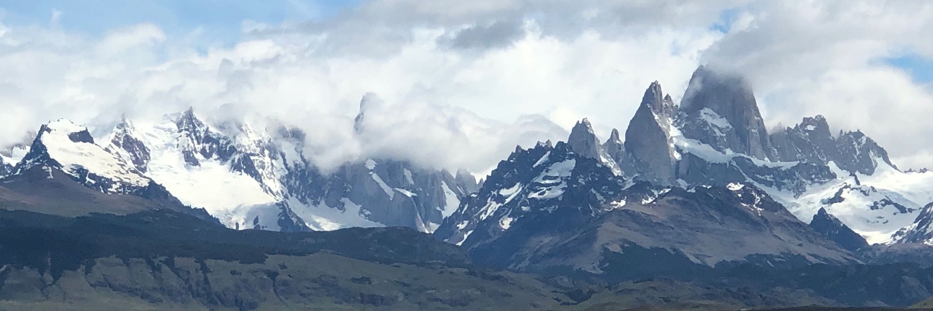
Lago Todos Los Santos, Chile

November 1, 2025 at 8:23 AM
Lago Todos Los Santos, Chile
Happendon 1978. Another from the golden age of scribing. I was familiar with the map from Harvey's JK stands. Now only the eastern part is used, it is not possible to cross the motorway that has been built since. #OldOrienteeringMaps, #Orienteering #Lanarkshire


October 31, 2025 at 2:40 PM
Happendon 1978. Another from the golden age of scribing. I was familiar with the map from Harvey's JK stands. Now only the eastern part is used, it is not possible to cross the motorway that has been built since. #OldOrienteeringMaps, #Orienteering #Lanarkshire
Bill Gauld's #HolyroodPark, 1975. A map which was used for many years. When surveyed, the park was still grazed. Fewer whins and not many trees. #OldOrienteeringMaps #Edinburgh #Orienteering #Maps #EUOC


October 30, 2025 at 4:51 PM
Bill Gauld's #HolyroodPark, 1975. A map which was used for many years. When surveyed, the park was still grazed. Fewer whins and not many trees. #OldOrienteeringMaps #Edinburgh #Orienteering #Maps #EUOC
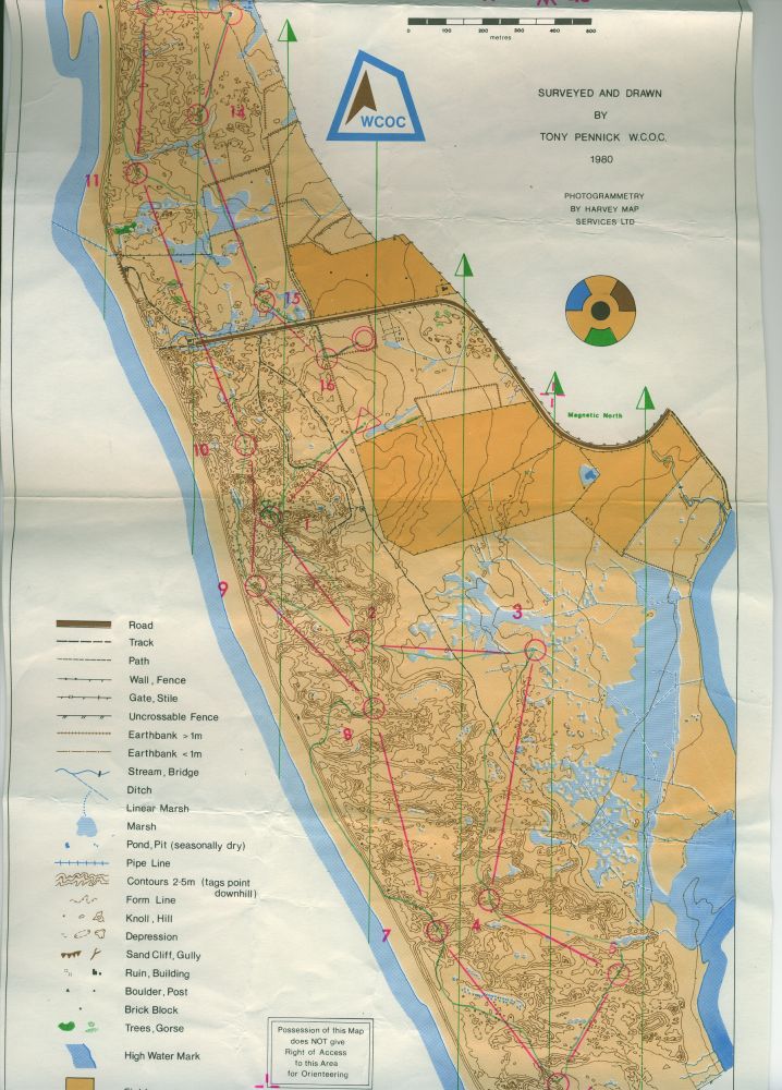
Drigg 1980, #Cumberland coast near a low level nuclear waste depository. A very fine #dune area, one I have not seen used for a long time now. #OldOrienteeringMaps #Orienteering #Maps #WestCumberlandOrienteeringClub #WCOC
October 29, 2025 at 8:16 AM
Drigg 1980, #Cumberland coast near a low level nuclear waste depository. A very fine #dune area, one I have not seen used for a long time now. #OldOrienteeringMaps #Orienteering #Maps #WestCumberlandOrienteeringClub #WCOC
#Cheviot Hills with #hillforts clearly visible on Hownam Law (background) and nearby Green Humbleton. Monday 27th Oct.

October 28, 2025 at 11:37 AM
#Cheviot Hills with #hillforts clearly visible on Hownam Law (background) and nearby Green Humbleton. Monday 27th Oct.
North of the Border - in England . Walked in down the Halter Burn from the Pennine Way to join the footpath network on the way to an ascent of Coldsmouth Hill.
Right hand edge of the picture (south) is in #Scotland #CheviotHills
Right hand edge of the picture (south) is in #Scotland #CheviotHills

October 27, 2025 at 8:16 PM
North of the Border - in England . Walked in down the Halter Burn from the Pennine Way to join the footpath network on the way to an ascent of Coldsmouth Hill.
Right hand edge of the picture (south) is in #Scotland #CheviotHills
Right hand edge of the picture (south) is in #Scotland #CheviotHills
Mill Dam, Dunkeld #Perthshire #Scotland

October 26, 2025 at 10:54 AM
Mill Dam, Dunkeld #Perthshire #Scotland
KrapKamping was not just a Covid phenomenon. Took this on the Loch of the Lowes nature reserve in 2013.

October 26, 2025 at 9:44 AM
KrapKamping was not just a Covid phenomenon. Took this on the Loch of the Lowes nature reserve in 2013.
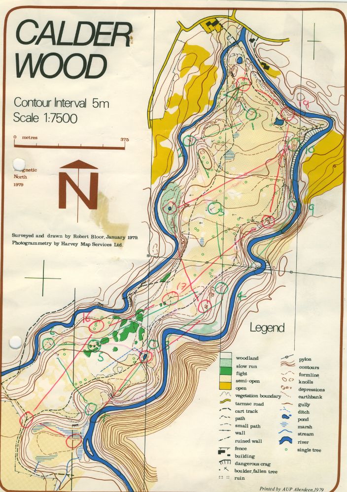
Calder Wood, 1979 Robert Bloor. Still in use. #OldOrienteeringMaps, #OrienteeringMaps #Maps #Interlopers #Orienteering

October 26, 2025 at 9:21 AM
Calder Wood, 1979 Robert Bloor. Still in use. #OldOrienteeringMaps, #OrienteeringMaps #Maps #Interlopers #Orienteering
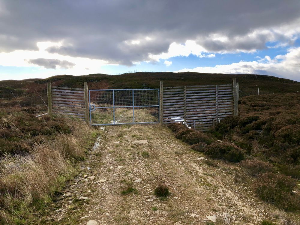
One of a large number of locked gates with no easy workround encountered above Butterstone #Perthshire yesterday. Even a narrow gate was locked.
Good news, the pines they planted are mostly still alive.
Good news, the pines they planted are mostly still alive.
October 26, 2025 at 9:08 AM
One of a large number of locked gates with no easy workround encountered above Butterstone #Perthshire yesterday. Even a narrow gate was locked.
Good news, the pines they planted are mostly still alive.
Good news, the pines they planted are mostly still alive.
Blackford Hill and the Braids 1978.
An #EUOC workhorse at the time. Two tiny fragments are now mapped and used alone - KB and Braidburn Valley Park. Southern part is a golf course and still used for night events.
#OldOrienteeringMaps #ESOC #Interlopers #OrienteeringMaps
An #EUOC workhorse at the time. Two tiny fragments are now mapped and used alone - KB and Braidburn Valley Park. Southern part is a golf course and still used for night events.
#OldOrienteeringMaps #ESOC #Interlopers #OrienteeringMaps


October 21, 2025 at 2:05 PM
Blackford Hill and the Braids 1978.
An #EUOC workhorse at the time. Two tiny fragments are now mapped and used alone - KB and Braidburn Valley Park. Southern part is a golf course and still used for night events.
#OldOrienteeringMaps #ESOC #Interlopers #OrienteeringMaps
An #EUOC workhorse at the time. Two tiny fragments are now mapped and used alone - KB and Braidburn Valley Park. Southern part is a golf course and still used for night events.
#OldOrienteeringMaps #ESOC #Interlopers #OrienteeringMaps
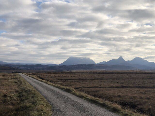
View from Isle Ristol. The closest of the Summer Isles with a short crossing from Old Dornie or walk across on a spring low water. A view to the mainland including Stac Pollaidh. The beach Traigh an t-Sean Bhaille is rather a good one.

October 20, 2025 at 8:25 AM
View from Isle Ristol. The closest of the Summer Isles with a short crossing from Old Dornie or walk across on a spring low water. A view to the mainland including Stac Pollaidh. The beach Traigh an t-Sean Bhaille is rather a good one.
October 19, 2025 at 4:08 PM
October 19, 2025 at 10:39 AM
A lone tree island in Loch Assynt, #Sutherland. Anticyclonic gloom, but an amazing flat loch. #Scotland #Weather

October 18, 2025 at 11:26 AM
A lone tree island in Loch Assynt, #Sutherland. Anticyclonic gloom, but an amazing flat loch. #Scotland #Weather
Loch Assynt, #Sutherland today - I had to wait before getting onto the water so as not to ruin the mirror for some photographers. Pictures from just off the north and southern shore of the loch.Best reflections I have seen. Had to be quick as the ripples from paddling would get in front if I delayed


October 14, 2025 at 7:49 PM
Loch Assynt, #Sutherland today - I had to wait before getting onto the water so as not to ruin the mirror for some photographers. Pictures from just off the north and southern shore of the loch.Best reflections I have seen. Had to be quick as the ripples from paddling would get in front if I delayed