Falls City Weather
@fallscitywx.bsky.social
#𝔽𝔸𝕃𝕃𝕊ℂ𝕀𝕋𝕐𝕎𝕩 #𝔽ℂ𝕎𝕩 #𝟝𝟶𝟚𝕎𝕩 is for discussion of Greater Louisville Weather, past, present, and future, and even weather in general. #i65wx
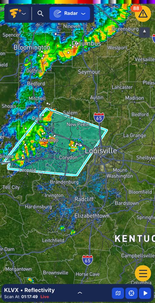
A FLASH FLOOD WARNING is now in effect for much of Louisville and Jefferson County until 2:15 PM EDT.
Be mindful while driving near low lying areas prone to flooding as well as creeks and streams.
#TURNAROUNDDONTDROWN
#FallsCityWx #FCWx #502wx #lmkwx #i65wx #wx #kywx #inwx
Be mindful while driving near low lying areas prone to flooding as well as creeks and streams.
#TURNAROUNDDONTDROWN
#FallsCityWx #FCWx #502wx #lmkwx #i65wx #wx #kywx #inwx

October 7, 2025 at 3:18 PM
A FLASH FLOOD WARNING is now in effect for much of Louisville and Jefferson County until 2:15 PM EDT.
Be mindful while driving near low lying areas prone to flooding as well as creeks and streams.
#TURNAROUNDDONTDROWN
#FallsCityWx #FCWx #502wx #lmkwx #i65wx #wx #kywx #inwx
Be mindful while driving near low lying areas prone to flooding as well as creeks and streams.
#TURNAROUNDDONTDROWN
#FallsCityWx #FCWx #502wx #lmkwx #i65wx #wx #kywx #inwx
It’s a waterlogged night following a wet & gloomy #Monday. However, this 🌧️ is much needed, and it will continue steadily into tomorrow with a front sagging into the area and shortwaves traveling along it to enhance 🌧️.
#FallsCityWx #FCWx #502wx #lmkwx #i65wx #wx #kywx #inwx
#FallsCityWx #FCWx #502wx #lmkwx #i65wx #wx #kywx #inwx
October 7, 2025 at 1:01 AM
After undergoing a significant disruption to its structure due to wind shear, #HurricaneErin is back on the mend and is expansive.
#FallsCityWx #FCWx #502wx #lmkwx #i65wx #wx #kywx #inwx #ncwx #tropics #tropicalwx
#FallsCityWx #FCWx #502wx #lmkwx #i65wx #wx #kywx #inwx #ncwx #tropics #tropicalwx
August 20, 2025 at 6:14 PM
After undergoing a significant disruption to its structure due to wind shear, #HurricaneErin is back on the mend and is expansive.
#FallsCityWx #FCWx #502wx #lmkwx #i65wx #wx #kywx #inwx #ncwx #tropics #tropicalwx
#FallsCityWx #FCWx #502wx #lmkwx #i65wx #wx #kywx #inwx #ncwx #tropics #tropicalwx

If #HurricaneErin wasn’t evidence enough, here’s more the #CapeVerde Machine is running. More hurricanes in the Atlantic can be expected in the coming 10-14 days, as we’re approaching peak season.
#FallsCityWx #FCWx #502wx #lmkwx #i65wx #wx #kywx #inwx #tropics #tropicalwx
#FallsCityWx #FCWx #502wx #lmkwx #i65wx #wx #kywx #inwx #tropics #tropicalwx

August 19, 2025 at 12:44 AM
If #HurricaneErin wasn’t evidence enough, here’s more the #CapeVerde Machine is running. More hurricanes in the Atlantic can be expected in the coming 10-14 days, as we’re approaching peak season.
#FallsCityWx #FCWx #502wx #lmkwx #i65wx #wx #kywx #inwx #tropics #tropicalwx
#FallsCityWx #FCWx #502wx #lmkwx #i65wx #wx #kywx #inwx #tropics #tropicalwx
#HurricaneErin looking ferocious from the San Juan radar.
#FallsCityWx #FCWx #502wx #lmkwx #i65wx #wx #kywx #inwx #tropics #tropicalwx
#FallsCityWx #FCWx #502wx #lmkwx #i65wx #wx #kywx #inwx #tropics #tropicalwx
August 17, 2025 at 12:47 AM
#HurricaneErin looking ferocious from the San Juan radar.
#FallsCityWx #FCWx #502wx #lmkwx #i65wx #wx #kywx #inwx #tropics #tropicalwx
#FallsCityWx #FCWx #502wx #lmkwx #i65wx #wx #kywx #inwx #tropics #tropicalwx
#HurricaneErin has become the first hurricane this season, and it has reached #Category5 status amidst an all too familiar rapid intensification process.
It’s packing 160 mph winds with a pressure of 917 mb!
#FallsCityWx #FCWx #502wx #lmkwx #i65wx #wx #kywx #inwx #tropicalwx
It’s packing 160 mph winds with a pressure of 917 mb!
#FallsCityWx #FCWx #502wx #lmkwx #i65wx #wx #kywx #inwx #tropicalwx
August 16, 2025 at 4:01 PM
#HurricaneErin has become the first hurricane this season, and it has reached #Category5 status amidst an all too familiar rapid intensification process.
It’s packing 160 mph winds with a pressure of 917 mb!
#FallsCityWx #FCWx #502wx #lmkwx #i65wx #wx #kywx #inwx #tropicalwx
It’s packing 160 mph winds with a pressure of 917 mb!
#FallsCityWx #FCWx #502wx #lmkwx #i65wx #wx #kywx #inwx #tropicalwx


July 19, 2025 at 1:57 AM