


eweather
@eweather.bsky.social
Forecasts-Photography-Community. Download the free app today! When you seeweather, eweather! #CTwx #RIwx #MAwx #CTRiver #BlockIsland 📷🛥✈️🍷🍺⛷🚴🏿🌅

Will take a closer look at this later, but at the moment, no need to change

January 18, 2025 at 6:29 PM
Will take a closer look at this later, but at the moment, no need to change
⚠️❄️Winter storm watch issued for parts of SNE for Sunday afternoon through Monday morning.
Tough to work with the character limitations here so check the eweather app, X or Facebook for the details
Tough to work with the character limitations here so check the eweather app, X or Facebook for the details


January 17, 2025 at 8:57 PM
⚠️❄️Winter storm watch issued for parts of SNE for Sunday afternoon through Monday morning.
Tough to work with the character limitations here so check the eweather app, X or Facebook for the details
Tough to work with the character limitations here so check the eweather app, X or Facebook for the details
Watch for a few slick spots as light snow leaves a dusting in spots across SNE this evening. Southern areas are seeing more widespread flakes as expected.


January 17, 2025 at 1:39 AM
Watch for a few slick spots as light snow leaves a dusting in spots across SNE this evening. Southern areas are seeing more widespread flakes as expected.
Going to have to be patient with this one…the energy that’s the catalyst for the potential late weekend storm doesn’t even come onshore until early Thursday.
But the pattern says this may be our best chance yet for plowable snow in SNE for those who haven’t seen much yet.
But the pattern says this may be our best chance yet for plowable snow in SNE for those who haven’t seen much yet.

January 14, 2025 at 2:00 AM
Going to have to be patient with this one…the energy that’s the catalyst for the potential late weekend storm doesn’t even come onshore until early Thursday.
But the pattern says this may be our best chance yet for plowable snow in SNE for those who haven’t seen much yet.
But the pattern says this may be our best chance yet for plowable snow in SNE for those who haven’t seen much yet.
Continuing to watch the Sunday to Monday timeframe for potential snow. Stay tuned!

January 14, 2025 at 1:59 AM
Continuing to watch the Sunday to Monday timeframe for potential snow. Stay tuned!
⚠️Expect slick travel in many parts of CT to now linger into the evening commute
Snow should taper off as we approach the PM commute but there are two areas with moderate snow across south central CT and NW CT that are causing very slick travel.
Snow should taper off as we approach the PM commute but there are two areas with moderate snow across south central CT and NW CT that are causing very slick travel.

January 6, 2025 at 6:56 PM
⚠️Expect slick travel in many parts of CT to now linger into the evening commute
Snow should taper off as we approach the PM commute but there are two areas with moderate snow across south central CT and NW CT that are causing very slick travel.
Snow should taper off as we approach the PM commute but there are two areas with moderate snow across south central CT and NW CT that are causing very slick travel.
A bit more snow over CT. Very light, but the ground will get coated up in a few spots. 12pm radar shown.

January 6, 2025 at 5:07 PM
A bit more snow over CT. Very light, but the ground will get coated up in a few spots. 12pm radar shown.
Nice ocean effect snow going on in Boston

December 20, 2024 at 3:38 PM
Nice ocean effect snow going on in Boston
Best chance for a white Christmas in SNE….. 🥁🥁🥁…. Cape Cod!
National blend of models snowfall through 1am on Christmas.
National blend of models snowfall through 1am on Christmas.

December 18, 2024 at 3:46 AM
Best chance for a white Christmas in SNE….. 🥁🥁🥁…. Cape Cod!
National blend of models snowfall through 1am on Christmas.
National blend of models snowfall through 1am on Christmas.
Another hit of rain coming tomorrow night.

December 18, 2024 at 3:42 AM
Another hit of rain coming tomorrow night.
Showers, drizzle & periods of rain move through tonight. By 6-7am it should be moving off to the SE. Temps warm overnight. Icing will not be an issue.
Mild Tues as the sun returns during the afternoon. 50s… enjoy it, bc it’s the mildest day of the week. Turning sharply colder this weekend.
Mild Tues as the sun returns during the afternoon. 50s… enjoy it, bc it’s the mildest day of the week. Turning sharply colder this weekend.

December 17, 2024 at 2:54 AM
Showers, drizzle & periods of rain move through tonight. By 6-7am it should be moving off to the SE. Temps warm overnight. Icing will not be an issue.
Mild Tues as the sun returns during the afternoon. 50s… enjoy it, bc it’s the mildest day of the week. Turning sharply colder this weekend.
Mild Tues as the sun returns during the afternoon. 50s… enjoy it, bc it’s the mildest day of the week. Turning sharply colder this weekend.
Rainfall amounts. Look how all the models were west with that max swath of rainfall that ended up over SE CT, RI and E MA. Models are good but they aren’t perfect - especially yesterday.


December 12, 2024 at 5:27 PM
Rainfall amounts. Look how all the models were west with that max swath of rainfall that ended up over SE CT, RI and E MA. Models are good but they aren’t perfect - especially yesterday.
I’m bullish on tomorrow. This is a high impact storm that may catch some by surprise. It’s been a while. Heavy rain. Snow melt. Damaging winds. Thunder. Waterspouts. We could be looking at 100k+ outages across SNE this time tomorrow night. Should be interesting.
December 11, 2024 at 3:31 AM
I’m bullish on tomorrow. This is a high impact storm that may catch some by surprise. It’s been a while. Heavy rain. Snow melt. Damaging winds. Thunder. Waterspouts. We could be looking at 100k+ outages across SNE this time tomorrow night. Should be interesting.
Latest modeled rainfall for Wednesday from the Euro, GFS and Canadian. A soaker! 1-3” likely. Locally higher amounts possible.

December 9, 2024 at 9:04 PM
Latest modeled rainfall for Wednesday from the Euro, GFS and Canadian. A soaker! 1-3” likely. Locally higher amounts possible.
Here comes the rain at 1:30 PM

December 9, 2024 at 6:30 PM
Here comes the rain at 1:30 PM
Lots of rain coming this week. Some tomorrow afternoon. A lot on Wednesday.
The model blend is over 3” for almost everyone.
The model blend is over 3” for almost everyone.

December 9, 2024 at 3:36 AM
Lots of rain coming this week. Some tomorrow afternoon. A lot on Wednesday.
The model blend is over 3” for almost everyone.
The model blend is over 3” for almost everyone.
Who’s seeing some light snow out there? 10:15pm radar included.

December 8, 2024 at 3:15 AM
Who’s seeing some light snow out there? 10:15pm radar included.
It’s been dry and we are still in drought…but lots of rain looking likely next week. This is the model blend rainfall - some individual runs are giving spots 5”+ of rain.


December 7, 2024 at 8:29 PM
It’s been dry and we are still in drought…but lots of rain looking likely next week. This is the model blend rainfall - some individual runs are giving spots 5”+ of rain.
Streamers from NY lake effect snow continues to make it into the Berkshires this afternoon.


December 7, 2024 at 8:04 PM
Streamers from NY lake effect snow continues to make it into the Berkshires this afternoon.
1:15am…the freezing line and snow is fairly far south. Maybe a few surprises outside the hill towns coming overnight…


December 5, 2024 at 6:20 AM
1:15am…the freezing line and snow is fairly far south. Maybe a few surprises outside the hill towns coming overnight…
Here’s the idea on snow tonight. Highly elevation driven.

December 4, 2024 at 3:08 PM
Here’s the idea on snow tonight. Highly elevation driven.
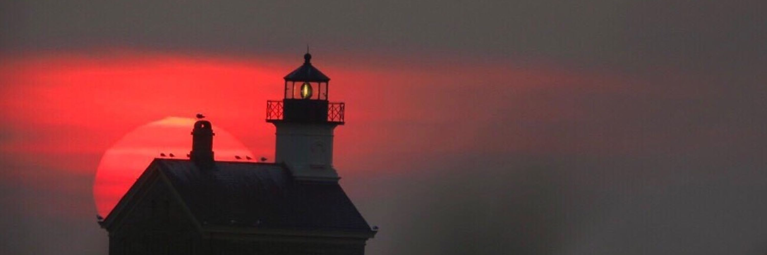
Ocean effect snow on Block Island right now.

December 2, 2024 at 2:10 AM
Ocean effect snow on Block Island right now.
We received some rain recently but fall 2024 (Sept, Oct, Nov) in the Hartford area goes down as the driest on record over the last 119 years by 0.24”! Impressive.
No surprise much of SNE is still in a severe to extreme drought. The latest rainfall is not incorporated into the latest Drought Monitor.
No surprise much of SNE is still in a severe to extreme drought. The latest rainfall is not incorporated into the latest Drought Monitor.


December 1, 2024 at 3:49 AM
We received some rain recently but fall 2024 (Sept, Oct, Nov) in the Hartford area goes down as the driest on record over the last 119 years by 0.24”! Impressive.
No surprise much of SNE is still in a severe to extreme drought. The latest rainfall is not incorporated into the latest Drought Monitor.
No surprise much of SNE is still in a severe to extreme drought. The latest rainfall is not incorporated into the latest Drought Monitor.
Euro with a touch of enhancement modeled for the clipper system Wednesday night. Widespread first flakes possible. Coating to 1”. But worth watching.


November 30, 2024 at 3:34 AM
Euro with a touch of enhancement modeled for the clipper system Wednesday night. Widespread first flakes possible. Coating to 1”. But worth watching.