


Dr. Eric J. Fielding, PhD
@ericfielding.mastodon.social.ap.brid.gy
Geophysicist at lab in Pasadena, California. Statements and opinions posted by me are my own and not those of my employer. he/him. Header image is […]
🌉 bridged from https://mastodon.social/@EricFielding on the fediverse by https://fed.brid.gy/
🌉 bridged from https://mastodon.social/@EricFielding on the fediverse by https://fed.brid.gy/
The Vantor company (formerly Maxar) used one of their Worldview satellites to capture a picture of the NASA-ISRO SAR (NISAR) satellite in orbit. The large radar reflector (12 meters or 38 feet wide) has a mesh surface that appears gold and the solar panels on […]
[Original post on mastodon.social]
[Original post on mastodon.social]

October 17, 2025 at 8:13 PM
The Vantor company (formerly Maxar) used one of their Worldview satellites to capture a picture of the NASA-ISRO SAR (NISAR) satellite in orbit. The large radar reflector (12 meters or 38 feet wide) has a mesh surface that appears gold and the solar panels on […]
[Original post on mastodon.social]
[Original post on mastodon.social]
@sundogplanets That is really interesting to see those structures near Al Hait. I did not find the spot you showed, but I found many near the city of Al Hait. It looks like they are built out of basalt rubble and are located on or near a large basalt lava […]
[Original post on mastodon.social]
[Original post on mastodon.social]

July 7, 2025 at 3:45 PM
@sundogplanets That is really interesting to see those structures near Al Hait. I did not find the spot you showed, but I found many near the city of Al Hait. It looks like they are built out of basalt rubble and are located on or near a large basalt lava […]
[Original post on mastodon.social]
[Original post on mastodon.social]
The bad air has moved inland since last night and the air quality in Pasadena is worse this morning. New map at 10 AM PDT from PurpleAir.

July 5, 2025 at 5:28 PM
The bad air has moved inland since last night and the air quality in Pasadena is worse this morning. New map at 10 AM PDT from PurpleAir.
There is little breeze in the LA area, except near the coast, so most of the LA basin has horrible air quality at 11 PM on the Fourth of July due to all the fireworks, as usual. Pasadena and adjacent cities decided to use drone light shows instead of […]
[Original post on mastodon.social]
[Original post on mastodon.social]

July 5, 2025 at 6:37 AM
There is little breeze in the LA area, except near the coast, so most of the LA basin has horrible air quality at 11 PM on the Fourth of July due to all the fireworks, as usual. Pasadena and adjacent cities decided to use drone light shows instead of […]
[Original post on mastodon.social]
[Original post on mastodon.social]
NASA-funded ATLAS (Asteroid Terrestrial-impact Last Alert System) telescope in Chile first detected interstellar comet that has now been named 3I/ATLAS on July 1, 2025. The object was then found in images from other telescopes going back to June 14 that […]
[Original post on mastodon.social]
[Original post on mastodon.social]

July 3, 2025 at 5:28 PM
NASA-funded ATLAS (Asteroid Terrestrial-impact Last Alert System) telescope in Chile first detected interstellar comet that has now been named 3I/ATLAS on July 1, 2025. The object was then found in images from other telescopes going back to June 14 that […]
[Original post on mastodon.social]
[Original post on mastodon.social]
Multiple fires in central and northern Saskatchewan
file:///private/var/mobile/Library/Mobile%20Documents/com~apple~CloudDocs/Downloads/Export/Export.png
file:///private/var/mobile/Library/Mobile%20Documents/com~apple~CloudDocs/Downloads/Export/Export.png

May 30, 2025 at 11:20 PM
Multiple fires in central and northern Saskatchewan
file:///private/var/mobile/Library/Mobile%20Documents/com~apple~CloudDocs/Downloads/Export/Export.png
file:///private/var/mobile/Library/Mobile%20Documents/com~apple~CloudDocs/Downloads/Export/Export.png

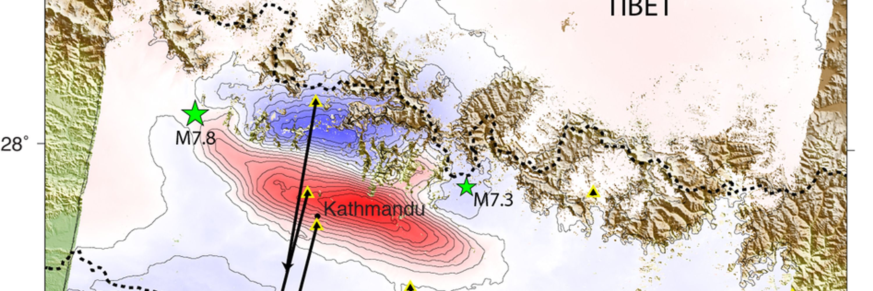
NASA JPL ARIA project analysis of data from Copernicus Sentinel-2 optical and Sentinel-1 radar images measured the slip on the Sagaing Fault in Myanmar. Quick preliminary map. More details later. Fault ruptured about 500 km (300 miles) in the magnitude 7.7 […]
[Original post on mastodon.social]
[Original post on mastodon.social]

April 1, 2025 at 6:36 PM
NASA JPL ARIA project analysis of data from Copernicus Sentinel-2 optical and Sentinel-1 radar images measured the slip on the Sagaing Fault in Myanmar. Quick preliminary map. More details later. Fault ruptured about 500 km (300 miles) in the magnitude 7.7 […]
[Original post on mastodon.social]
[Original post on mastodon.social]
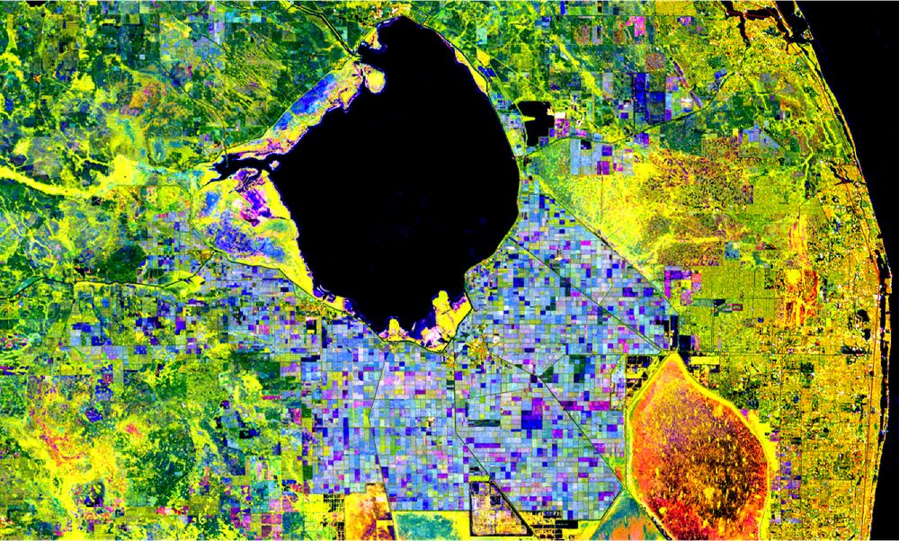
NASA-ISRO Mission Will Map Farmland From Planting to Harvest. The NASA-ISRO SAR (synthetic aperture radar) satellite will be launched soon and acquire radar over the entire land area of the Earth (except a few places near the poles). One objective is mapping […]
[Original post on mastodon.social]
[Original post on mastodon.social]
March 16, 2025 at 6:48 PM
NASA-ISRO Mission Will Map Farmland From Planting to Harvest. The NASA-ISRO SAR (synthetic aperture radar) satellite will be launched soon and acquire radar over the entire land area of the Earth (except a few places near the poles). One objective is mapping […]
[Original post on mastodon.social]
[Original post on mastodon.social]
Firefly Aerospace photo of Lunar Eclipse taken by their Blue Ghost 1 lander on the Moon.
"Firefly’s Blue Ghost lunar lander captured the diamond ring effect during a total solar eclipse captured around 3:30 am CST on March 14 from the Moon’s Mare Crisium. Credit: Firefly Aerospace"
"Firefly’s Blue Ghost lunar lander captured the diamond ring effect during a total solar eclipse captured around 3:30 am CST on March 14 from the Moon’s Mare Crisium. Credit: Firefly Aerospace"

March 14, 2025 at 3:17 PM
Firefly Aerospace photo of Lunar Eclipse taken by their Blue Ghost 1 lander on the Moon.
"Firefly’s Blue Ghost lunar lander captured the diamond ring effect during a total solar eclipse captured around 3:30 am CST on March 14 from the Moon’s Mare Crisium. Credit: Firefly Aerospace"
"Firefly’s Blue Ghost lunar lander captured the diamond ring effect during a total solar eclipse captured around 3:30 am CST on March 14 from the Moon’s Mare Crisium. Credit: Firefly Aerospace"
The full map is attached below, with the zooms on the Eaton Fire, Palisades Fire, and Lidia Fire, and covers area indicated by the white polygon. Damage is shown by colored pixels of 30m in size, where yellow to red indicates increasingly significant ground […]
[Original post on mastodon.social]
[Original post on mastodon.social]

January 11, 2025 at 5:38 PM
The full map is attached below, with the zooms on the Eaton Fire, Palisades Fire, and Lidia Fire, and covers area indicated by the white polygon. Damage is shown by colored pixels of 30m in size, where yellow to red indicates increasingly significant ground […]
[Original post on mastodon.social]
[Original post on mastodon.social]
Colleague Sang-Ho Yun at Earth Observatory of Singapore Remote Sensing Lab and his team made a Damage Proxy Map (DPM) from Copernicus Sentinel-1 radar image over the LA, California area acquired at 2 AM UTC 9 Jan. or 6 PM PT January 8, compared with previous […]
[Original post on mastodon.social]
[Original post on mastodon.social]

January 11, 2025 at 5:26 PM
Colleague Sang-Ho Yun at Earth Observatory of Singapore Remote Sensing Lab and his team made a Damage Proxy Map (DPM) from Copernicus Sentinel-1 radar image over the LA, California area acquired at 2 AM UTC 9 Jan. or 6 PM PT January 8, compared with previous […]
[Original post on mastodon.social]
[Original post on mastodon.social]
@ai6yr Fortunately, where I live in Pasadena seems to be below AQI 200, although there is a huge variation in readings from PurpleAir sensors. I wonder if some are actually inside buildings.

January 10, 2025 at 4:54 PM
@ai6yr Fortunately, where I live in Pasadena seems to be below AQI 200, although there is a huge variation in readings from PurpleAir sensors. I wonder if some are actually inside buildings.
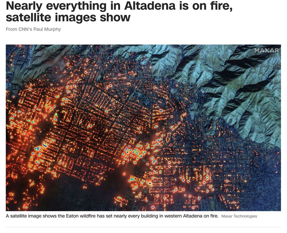
CNN published a satellite image acquired by the Maxar satellites at 10:45 a.m. PT on January 7. They used the short-wave infrared channels to see the fires through the smoke and clouds. It is a devastating view of almost every house burning over most of the […]
[Original post on mastodon.social]
[Original post on mastodon.social]
January 9, 2025 at 5:12 AM
CNN published a satellite image acquired by the Maxar satellites at 10:45 a.m. PT on January 7. They used the short-wave infrared channels to see the fires through the smoke and clouds. It is a devastating view of almost every house burning over most of the […]
[Original post on mastodon.social]
[Original post on mastodon.social]
Currently, the evacuation orders have extended over a large area north, west, and east of Pasadena. I live a mile south of the 210 freeway in Pasadena, so we are not in the evacuation zone or the warning area. #eatonfire Map from Watch Duty showing evacuation area from La Cañada to Monrovia

January 8, 2025 at 2:17 PM
Currently, the evacuation orders have extended over a large area north, west, and east of Pasadena. I live a mile south of the 210 freeway in Pasadena, so we are not in the evacuation zone or the warning area. #eatonfire Map from Watch Duty showing evacuation area from La Cañada to Monrovia
Fire burning in Eaton Canyon of Altadena, just north of Pasadena, California, called the Eaton Fire. 🔥 already 200 acres. Watch Duty map below.

January 8, 2025 at 4:02 AM
Fire burning in Eaton Canyon of Altadena, just north of Pasadena, California, called the Eaton Fire. 🔥 already 200 acres. Watch Duty map below.