


EPAWA Weather Consulting
@epawa.bsky.social
EPAWA Weather Consulting, LLC is a public and private meteorological consulting firm headquartered in Lehigh Valley, PA, which provides customized forecasts to business entities in Pennsylvania, New Jersey, Delaware, and Maryland.
𝗟𝗼𝗻𝗴 𝗿𝗮𝗻𝗴𝗲 𝗼𝘂𝘁𝗹𝗼𝗼𝗸: 𝗙𝗿𝗶𝗱𝗮𝘆 𝗡𝗼𝘃𝗲𝗺𝗯𝗲𝗿 𝟮𝟭𝘀𝘁:
View it here: epawaweather.com/long-range-o...
Our weekly long range outlook takes a look at the next 5-6 weeks of temps/pattern and precipitation/snowfall into broken down time periods.
View it here: epawaweather.com/long-range-o...
Our weekly long range outlook takes a look at the next 5-6 weeks of temps/pattern and precipitation/snowfall into broken down time periods.

November 21, 2025 at 3:07 PM
𝗟𝗼𝗻𝗴 𝗿𝗮𝗻𝗴𝗲 𝗼𝘂𝘁𝗹𝗼𝗼𝗸: 𝗙𝗿𝗶𝗱𝗮𝘆 𝗡𝗼𝘃𝗲𝗺𝗯𝗲𝗿 𝟮𝟭𝘀𝘁:
View it here: epawaweather.com/long-range-o...
Our weekly long range outlook takes a look at the next 5-6 weeks of temps/pattern and precipitation/snowfall into broken down time periods.
View it here: epawaweather.com/long-range-o...
Our weekly long range outlook takes a look at the next 5-6 weeks of temps/pattern and precipitation/snowfall into broken down time periods.
𝗟𝗼𝗻𝗴 𝗿𝗮𝗻𝗴𝗲 𝗼𝘂𝘁𝗹𝗼𝗼𝗸: 𝗙𝗿𝗶𝗱𝗮𝘆 𝗡𝗼𝘃𝗲𝗺𝗯𝗲𝗿 𝟭𝟰𝘁𝗵:
View it here: epawaweather.com/long-range-o...
Our weekly long range outlook takes a look at the next 5-6 weeks of temps/pattern and precipitation/snowfall into broken down time periods.
View it here: epawaweather.com/long-range-o...
Our weekly long range outlook takes a look at the next 5-6 weeks of temps/pattern and precipitation/snowfall into broken down time periods.
November 14, 2025 at 3:08 PM
𝗟𝗼𝗻𝗴 𝗿𝗮𝗻𝗴𝗲 𝗼𝘂𝘁𝗹𝗼𝗼𝗸: 𝗙𝗿𝗶𝗱𝗮𝘆 𝗡𝗼𝘃𝗲𝗺𝗯𝗲𝗿 𝟭𝟰𝘁𝗵:
View it here: epawaweather.com/long-range-o...
Our weekly long range outlook takes a look at the next 5-6 weeks of temps/pattern and precipitation/snowfall into broken down time periods.
View it here: epawaweather.com/long-range-o...
Our weekly long range outlook takes a look at the next 5-6 weeks of temps/pattern and precipitation/snowfall into broken down time periods.
Long range outlook: Friday November 7th:
View it here: epawaweather.com/long-range-o...
Our weekly long range outlook takes a look at the next 5-6 weeks of temps/pattern and precipitation/snowfall into broken down time periods. Today's outlook projects through the end of 2025.
View it here: epawaweather.com/long-range-o...
Our weekly long range outlook takes a look at the next 5-6 weeks of temps/pattern and precipitation/snowfall into broken down time periods. Today's outlook projects through the end of 2025.
November 7, 2025 at 3:05 PM
Long range outlook: Friday November 7th:
View it here: epawaweather.com/long-range-o...
Our weekly long range outlook takes a look at the next 5-6 weeks of temps/pattern and precipitation/snowfall into broken down time periods. Today's outlook projects through the end of 2025.
View it here: epawaweather.com/long-range-o...
Our weekly long range outlook takes a look at the next 5-6 weeks of temps/pattern and precipitation/snowfall into broken down time periods. Today's outlook projects through the end of 2025.
Long range outlook: epawaweather.com/long-range-o...
Friday October 24th weekly Long Range Outlook takes a look at the next 5-6 weeks of temps/pattern and precipitation into broken down time periods.
Friday October 24th weekly Long Range Outlook takes a look at the next 5-6 weeks of temps/pattern and precipitation into broken down time periods.
October 24, 2025 at 2:34 PM
Long range outlook: epawaweather.com/long-range-o...
Friday October 24th weekly Long Range Outlook takes a look at the next 5-6 weeks of temps/pattern and precipitation into broken down time periods.
Friday October 24th weekly Long Range Outlook takes a look at the next 5-6 weeks of temps/pattern and precipitation into broken down time periods.
Long range outlook: epawaweather.com/long-range-o...
Friday October 17th weekly Long Range Outlook takes a look at the next 5-6 weeks of temps/pattern and precipitation into broken down time periods.
Friday October 17th weekly Long Range Outlook takes a look at the next 5-6 weeks of temps/pattern and precipitation into broken down time periods.
October 17, 2025 at 2:18 PM
Long range outlook: epawaweather.com/long-range-o...
Friday October 17th weekly Long Range Outlook takes a look at the next 5-6 weeks of temps/pattern and precipitation into broken down time periods.
Friday October 17th weekly Long Range Outlook takes a look at the next 5-6 weeks of temps/pattern and precipitation into broken down time periods.
Long range outlook: epawaweather.com/long-range-o...
Friday October 10th weekly Long Range Outlook takes a look at the next 5-6 weeks of temps/pattern and precipitation into broken down time periods.
Friday October 10th weekly Long Range Outlook takes a look at the next 5-6 weeks of temps/pattern and precipitation into broken down time periods.
October 10, 2025 at 3:17 PM
Long range outlook: epawaweather.com/long-range-o...
Friday October 10th weekly Long Range Outlook takes a look at the next 5-6 weeks of temps/pattern and precipitation into broken down time periods.
Friday October 10th weekly Long Range Outlook takes a look at the next 5-6 weeks of temps/pattern and precipitation into broken down time periods.
𝗦𝘂𝗺𝗺𝗲𝗿'𝘀 𝗹𝗮𝘀𝘁 𝗴𝗮𝘀𝗽?
If you're tired of the 80s, you'll just have to get through the Saturday October 4th through Tuesday October 7th period, then temps more Autumn-like return. This 𝒔𝒉𝒐𝒖𝒍𝒅 be the last stretch of 80s this year...
If you're tired of the 80s, you'll just have to get through the Saturday October 4th through Tuesday October 7th period, then temps more Autumn-like return. This 𝒔𝒉𝒐𝒖𝒍𝒅 be the last stretch of 80s this year...

October 2, 2025 at 7:35 PM
𝗦𝘂𝗺𝗺𝗲𝗿'𝘀 𝗹𝗮𝘀𝘁 𝗴𝗮𝘀𝗽?
If you're tired of the 80s, you'll just have to get through the Saturday October 4th through Tuesday October 7th period, then temps more Autumn-like return. This 𝒔𝒉𝒐𝒖𝒍𝒅 be the last stretch of 80s this year...
If you're tired of the 80s, you'll just have to get through the Saturday October 4th through Tuesday October 7th period, then temps more Autumn-like return. This 𝒔𝒉𝒐𝒖𝒍𝒅 be the last stretch of 80s this year...
The FINAL beach forecasts of the 2025 season have been issued for Southern NJ and Delaware/OCMD beaches ahead of Labor Day weekend. Get the latest forecast, tides, and marine info to plan your trip.
Choose your destination~> epawaweather.com/beach-foreca...
Choose your destination~> epawaweather.com/beach-foreca...

August 28, 2025 at 1:01 PM
The FINAL beach forecasts of the 2025 season have been issued for Southern NJ and Delaware/OCMD beaches ahead of Labor Day weekend. Get the latest forecast, tides, and marine info to plan your trip.
Choose your destination~> epawaweather.com/beach-foreca...
Choose your destination~> epawaweather.com/beach-foreca...
𝗕𝗲𝗮𝗰𝗵 𝗙𝗼𝗿𝗲𝗰𝗮𝘀𝘁𝘀 have been completed for this week for Southern NJ and Delaware/OCMD beaches. Get the latest forecast, tides, and marine info to plan your trip. Rough seas next two days in the wake of Hurricane Erin.
Choose your destination~> epawaweather.com/beach-foreca...
Choose your destination~> epawaweather.com/beach-foreca...

August 21, 2025 at 1:09 PM
𝗕𝗲𝗮𝗰𝗵 𝗙𝗼𝗿𝗲𝗰𝗮𝘀𝘁𝘀 have been completed for this week for Southern NJ and Delaware/OCMD beaches. Get the latest forecast, tides, and marine info to plan your trip. Rough seas next two days in the wake of Hurricane Erin.
Choose your destination~> epawaweather.com/beach-foreca...
Choose your destination~> epawaweather.com/beach-foreca...
𝗕𝗲𝗮𝗰𝗵 𝗙𝗼𝗿𝗲𝗰𝗮𝘀𝘁𝘀 have been completed for this week as they are every Thursday for Southern NJ and Delaware/OCMD beaches. Get the latest forecast, tides, and marine info to plan your trip.
Choose your destination~> epawaweather.com/beach-foreca...
Choose your destination~> epawaweather.com/beach-foreca...
August 7, 2025 at 2:17 PM
𝗕𝗲𝗮𝗰𝗵 𝗙𝗼𝗿𝗲𝗰𝗮𝘀𝘁𝘀 have been completed for this week as they are every Thursday for Southern NJ and Delaware/OCMD beaches. Get the latest forecast, tides, and marine info to plan your trip.
Choose your destination~> epawaweather.com/beach-foreca...
Choose your destination~> epawaweather.com/beach-foreca...

July 31, 2025 at 4:50 PM
𝗕𝗲𝗮𝗰𝗵 𝗙𝗼𝗿𝗲𝗰𝗮𝘀𝘁𝘀 have been completed for this week as they are every Thursday for Southern NJ and Delaware/OCMD beaches. Get the latest forecast, tides, and marine info to plan your trip.
Choose your destination~> epawaweather.com/beach-foreca...
Choose your destination~> epawaweather.com/beach-foreca...

July 24, 2025 at 2:08 PM
𝗕𝗲𝗮𝗰𝗵 𝗙𝗼𝗿𝗲𝗰𝗮𝘀𝘁𝘀 have been completed for this week as they are every Thursday for Southern NJ and Delaware/OCMD beaches. Get the latest forecast, tides, and marine info to plan your trip.
Choose your destination~> epawaweather.com/beach-foreca...
Choose your destination~> epawaweather.com/beach-foreca...
𝗕𝗲𝗮𝗰𝗵 𝗙𝗼𝗿𝗲𝗰𝗮𝘀𝘁𝘀 have been completed for this week for Southern NJ and Delaware/OCMD beaches. Get the latest forecast, tides, and marine info to adequately plan your trip. Fantastic holiday weekend upcoming!
Choose your destination~> epawaweather.com/beach-foreca...
Choose your destination~> epawaweather.com/beach-foreca...

July 3, 2025 at 1:19 PM
𝗕𝗲𝗮𝗰𝗵 𝗙𝗼𝗿𝗲𝗰𝗮𝘀𝘁𝘀 have been completed for this week for Southern NJ and Delaware/OCMD beaches. Get the latest forecast, tides, and marine info to adequately plan your trip. Fantastic holiday weekend upcoming!
Choose your destination~> epawaweather.com/beach-foreca...
Choose your destination~> epawaweather.com/beach-foreca...
Our June 27th long range outlook takes a look at the next 5-6 weeks of temps/pattern and precipitation into broken down time periods. Next week's update will be done on Thursday due to the holiday.
View it here~> epawaweather.com/long-range-o...
View it here~> epawaweather.com/long-range-o...
June 27, 2025 at 2:09 PM
Our June 27th long range outlook takes a look at the next 5-6 weeks of temps/pattern and precipitation into broken down time periods. Next week's update will be done on Thursday due to the holiday.
View it here~> epawaweather.com/long-range-o...
View it here~> epawaweather.com/long-range-o...
If you waited to take a beach trip, this weekend will be as good as any! Beach forecasts have been completed for this week for Southern NJ and Delaware/OCMD beaches. Get the latest forecast, tides, and marine info to plan your trip.
Choose your destination~> epawaweather.com/beach-foreca...
Choose your destination~> epawaweather.com/beach-foreca...

June 19, 2025 at 2:31 PM
If you waited to take a beach trip, this weekend will be as good as any! Beach forecasts have been completed for this week for Southern NJ and Delaware/OCMD beaches. Get the latest forecast, tides, and marine info to plan your trip.
Choose your destination~> epawaweather.com/beach-foreca...
Choose your destination~> epawaweather.com/beach-foreca...
Parts of the Poconos, NW New Jersey, and even parts of the Lehigh Valley could see rain mix with and change to snow very late tonight and early Saturday morning. Lower elevations can see a coating up to 2" on non-paved/elevated surfaces, and higher elevations could see 2" to as much as 5" of snow.

April 11, 2025 at 7:12 PM
Parts of the Poconos, NW New Jersey, and even parts of the Lehigh Valley could see rain mix with and change to snow very late tonight and early Saturday morning. Lower elevations can see a coating up to 2" on non-paved/elevated surfaces, and higher elevations could see 2" to as much as 5" of snow.
Weather Alerts has the latest information about the weekend storm with two maps, one for snow/sleet and one for freezing rain/ice.
View it here~> epawaweather.com/weather-aler...
View it here~> epawaweather.com/weather-aler...
February 7, 2025 at 9:58 PM
Weather Alerts has the latest information about the weekend storm with two maps, one for snow/sleet and one for freezing rain/ice.
View it here~> epawaweather.com/weather-aler...
View it here~> epawaweather.com/weather-aler...
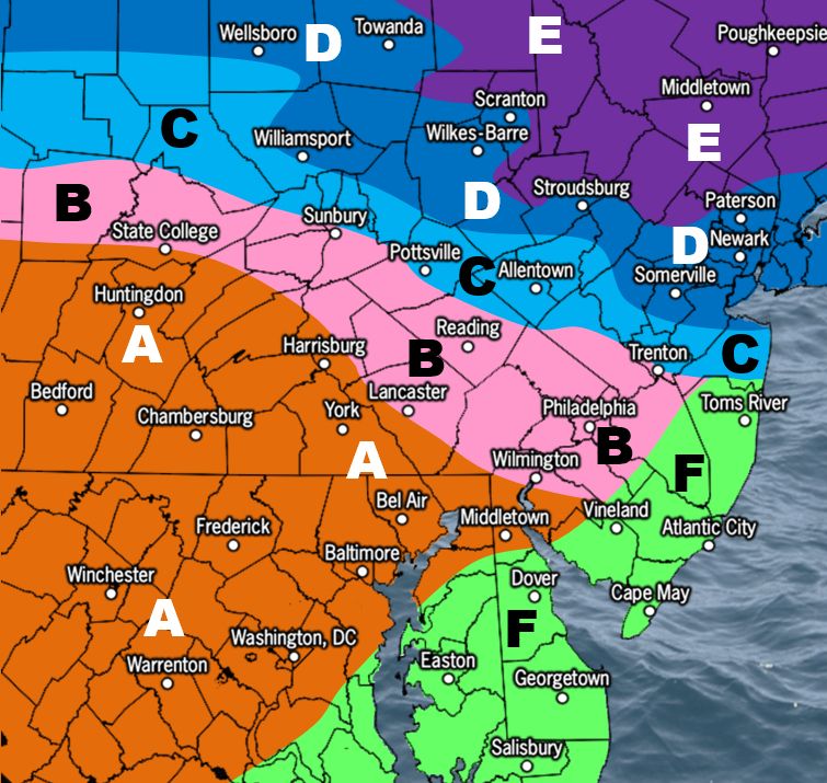
𝘼 𝙥𝙧𝙚𝙡𝙞𝙢𝙞𝙣𝙖𝙧𝙮 𝙨𝙚𝙣𝙨𝙞𝙗𝙡𝙚 𝙡𝙤𝙤𝙠 𝙖𝙩 𝙩𝙝𝙚 𝙬𝙚𝙚𝙠𝙚𝙣𝙙 𝙨𝙮𝙨𝙩𝙚𝙢...
We're sharing this today as a preliminary precipitation-type probability for 𝐒𝐚𝐭𝐮𝐫𝐝𝐚𝐲 𝐞𝐯𝐞𝐧𝐢𝐧𝐠 𝐢𝐧𝐭𝐨 𝐞𝐚𝐫𝐥𝐲 𝐒𝐮𝐧𝐝𝐚𝐲 𝐦𝐨𝐫𝐧𝐢𝐧𝐠. This is the best approach right now given the range of this event. We'll start the first official maps with ranges tomorrow.
We're sharing this today as a preliminary precipitation-type probability for 𝐒𝐚𝐭𝐮𝐫𝐝𝐚𝐲 𝐞𝐯𝐞𝐧𝐢𝐧𝐠 𝐢𝐧𝐭𝐨 𝐞𝐚𝐫𝐥𝐲 𝐒𝐮𝐧𝐝𝐚𝐲 𝐦𝐨𝐫𝐧𝐢𝐧𝐠. This is the best approach right now given the range of this event. We'll start the first official maps with ranges tomorrow.
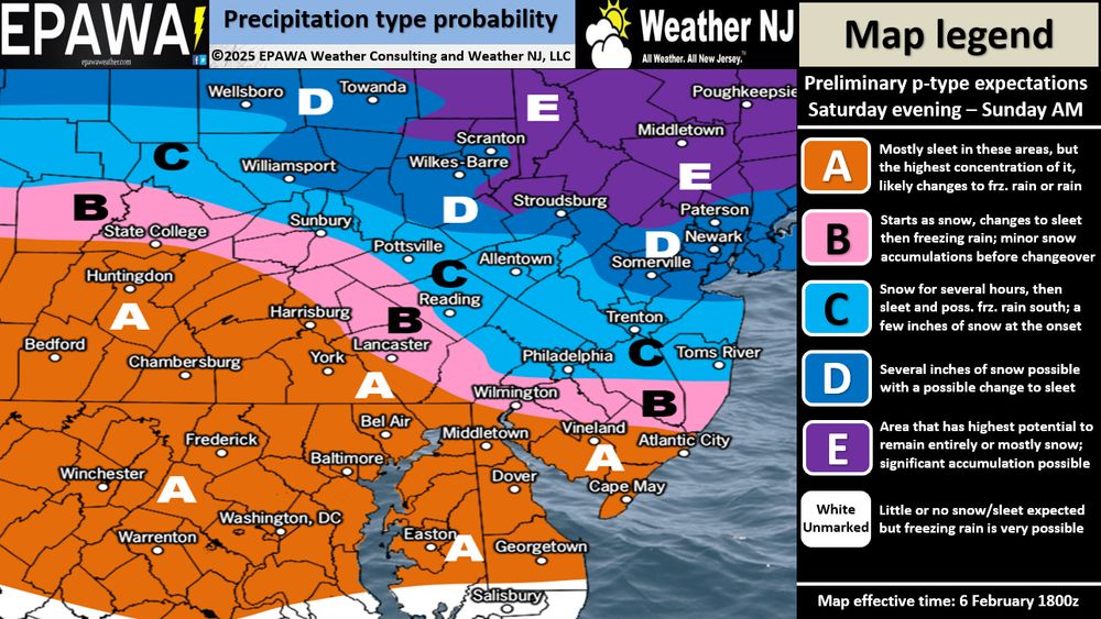
February 6, 2025 at 10:08 PM
𝘼 𝙥𝙧𝙚𝙡𝙞𝙢𝙞𝙣𝙖𝙧𝙮 𝙨𝙚𝙣𝙨𝙞𝙗𝙡𝙚 𝙡𝙤𝙤𝙠 𝙖𝙩 𝙩𝙝𝙚 𝙬𝙚𝙚𝙠𝙚𝙣𝙙 𝙨𝙮𝙨𝙩𝙚𝙢...
We're sharing this today as a preliminary precipitation-type probability for 𝐒𝐚𝐭𝐮𝐫𝐝𝐚𝐲 𝐞𝐯𝐞𝐧𝐢𝐧𝐠 𝐢𝐧𝐭𝐨 𝐞𝐚𝐫𝐥𝐲 𝐒𝐮𝐧𝐝𝐚𝐲 𝐦𝐨𝐫𝐧𝐢𝐧𝐠. This is the best approach right now given the range of this event. We'll start the first official maps with ranges tomorrow.
We're sharing this today as a preliminary precipitation-type probability for 𝐒𝐚𝐭𝐮𝐫𝐝𝐚𝐲 𝐞𝐯𝐞𝐧𝐢𝐧𝐠 𝐢𝐧𝐭𝐨 𝐞𝐚𝐫𝐥𝐲 𝐒𝐮𝐧𝐝𝐚𝐲 𝐦𝐨𝐫𝐧𝐢𝐧𝐠. This is the best approach right now given the range of this event. We'll start the first official maps with ranges tomorrow.
𝙁𝙞𝙣𝙖𝙡 𝙘𝙖𝙡𝙡 𝙛𝙤𝙧 𝙎𝙪𝙣𝙙𝙖𝙮'𝙨 𝙨𝙞𝙜𝙣𝙞𝙛𝙞𝙘𝙖𝙣𝙩 𝙨𝙣𝙤𝙬𝙛𝙖𝙡𝙡
View it here~> epawaweather.com/weather-aler...
Slight adjustment to snow ranges appears on Weather Alerts with full map (with legend) including a timing and impacts discussion
View it here~> epawaweather.com/weather-aler...
Slight adjustment to snow ranges appears on Weather Alerts with full map (with legend) including a timing and impacts discussion

January 18, 2025 at 8:59 PM
𝙁𝙞𝙣𝙖𝙡 𝙘𝙖𝙡𝙡 𝙛𝙤𝙧 𝙎𝙪𝙣𝙙𝙖𝙮'𝙨 𝙨𝙞𝙜𝙣𝙞𝙛𝙞𝙘𝙖𝙣𝙩 𝙨𝙣𝙤𝙬𝙛𝙖𝙡𝙡
View it here~> epawaweather.com/weather-aler...
Slight adjustment to snow ranges appears on Weather Alerts with full map (with legend) including a timing and impacts discussion
View it here~> epawaweather.com/weather-aler...
Slight adjustment to snow ranges appears on Weather Alerts with full map (with legend) including a timing and impacts discussion
𝐒𝐢𝐠𝐧𝐢𝐟𝐢𝐜𝐚𝐧𝐭 𝐬𝐧𝐨𝐰𝐟𝐚𝐥𝐥 𝐟𝐨𝐫 𝐩𝐨𝐫𝐭𝐢𝐨𝐧𝐬 𝐨𝐟 𝐨𝐮𝐫 𝐫𝐞𝐠𝐢𝐨𝐧 𝐒𝐮𝐧𝐝𝐚𝐲
View it here~> epawaweather.com/weather-aler...
This is our first call which appears on Weather Alerts with the full map (with legend) including a timing and impacts discussion
View it here~> epawaweather.com/weather-aler...
This is our first call which appears on Weather Alerts with the full map (with legend) including a timing and impacts discussion

January 17, 2025 at 10:01 PM
𝐒𝐢𝐠𝐧𝐢𝐟𝐢𝐜𝐚𝐧𝐭 𝐬𝐧𝐨𝐰𝐟𝐚𝐥𝐥 𝐟𝐨𝐫 𝐩𝐨𝐫𝐭𝐢𝐨𝐧𝐬 𝐨𝐟 𝐨𝐮𝐫 𝐫𝐞𝐠𝐢𝐨𝐧 𝐒𝐮𝐧𝐝𝐚𝐲
View it here~> epawaweather.com/weather-aler...
This is our first call which appears on Weather Alerts with the full map (with legend) including a timing and impacts discussion
View it here~> epawaweather.com/weather-aler...
This is our first call which appears on Weather Alerts with the full map (with legend) including a timing and impacts discussion
Friday's long range outlook takes a look at the next 5-6 weeks of temps/pattern and precipitation into broken down time periods. Last week's Winter storm signal has become Sunday's actual storm.
View it here~> epawaweather.com/long-range-o...
View it here~> epawaweather.com/long-range-o...
January 17, 2025 at 4:01 PM
Friday's long range outlook takes a look at the next 5-6 weeks of temps/pattern and precipitation into broken down time periods. Last week's Winter storm signal has become Sunday's actual storm.
View it here~> epawaweather.com/long-range-o...
View it here~> epawaweather.com/long-range-o...
Fast-moving clipper in SE Quebec will bring snow showers and a heavier squall to parts of our region Thursday, in a late morning through mid-evening time window. C-1" for most, but this map highlights the areas that have the best chance to go over 1" with any heavier snow squalls that move through.

January 15, 2025 at 7:02 PM
Fast-moving clipper in SE Quebec will bring snow showers and a heavier squall to parts of our region Thursday, in a late morning through mid-evening time window. C-1" for most, but this map highlights the areas that have the best chance to go over 1" with any heavier snow squalls that move through.
This is for the minor event beginning after midnight tonight and ending very early Saturday morning. Snow will stick to all surfaces and untreated roadways, but for our entire region it will be under 2" most likely of dry/powdery snow.

January 10, 2025 at 6:51 PM
This is for the minor event beginning after midnight tonight and ending very early Saturday morning. Snow will stick to all surfaces and untreated roadways, but for our entire region it will be under 2" most likely of dry/powdery snow.
The Friday 1/10 long range outlook takes a look at the next 5-6 weeks of temps/pattern and precipitation into broken down time periods. Overall cold continues to headline the month of January.
View it here~> epawaweather.com/long-range-o...
View it here~> epawaweather.com/long-range-o...
January 10, 2025 at 3:34 PM
The Friday 1/10 long range outlook takes a look at the next 5-6 weeks of temps/pattern and precipitation into broken down time periods. Overall cold continues to headline the month of January.
View it here~> epawaweather.com/long-range-o...
View it here~> epawaweather.com/long-range-o...
Friday's long range outlook takes a look at the next 5-6 weeks of temps/pattern and precipitation into broken down time periods. January temperature outlook was lowered further it today's update.
View it here~> epawaweather.com/long-range-o...
View it here~> epawaweather.com/long-range-o...
January 3, 2025 at 4:44 PM
Friday's long range outlook takes a look at the next 5-6 weeks of temps/pattern and precipitation into broken down time periods. January temperature outlook was lowered further it today's update.
View it here~> epawaweather.com/long-range-o...
View it here~> epawaweather.com/long-range-o...