


Erica Fischer
@enf.bsky.social
She is awake. She is not in acute distress. She is well-developed and well-groomed. She is not ill-appearing. Behavior is cooperative. Thought content normal.
Thank you! On their web site it looks like they call them "Multifunctional Lenses" so I will do some googling for that terminology now

November 24, 2025 at 1:29 AM
Thank you! On their web site it looks like they call them "Multifunctional Lenses" so I will do some googling for that terminology now
Do these progressive lenses actually exist, and if so, is there someone who will sell some to me?

November 23, 2025 at 7:22 AM
Do these progressive lenses actually exist, and if so, is there someone who will sell some to me?
Some taqueria Gorton for you from last night

November 12, 2025 at 3:34 PM
Some taqueria Gorton for you from last night
This should win some sort of award for least useful bike rack, although it is probably a pretty good bollard

November 3, 2025 at 7:30 AM
This should win some sort of award for least useful bike rack, although it is probably a pretty good bollard
DC: not entirely demolished yet

October 24, 2025 at 9:04 PM
DC: not entirely demolished yet
This land claim map calisphere.org/item/ark:/13... shows that the 14th Street creek was diverted into a ditch to reach the corner of 16th and Dolores, giving more reason to think that something similar might have happened on Douglass

September 28, 2025 at 9:17 PM
This land claim map calisphere.org/item/ark:/13... shows that the 14th Street creek was diverted into a ditch to reach the corner of 16th and Dolores, giving more reason to think that something similar might have happened on Douglass
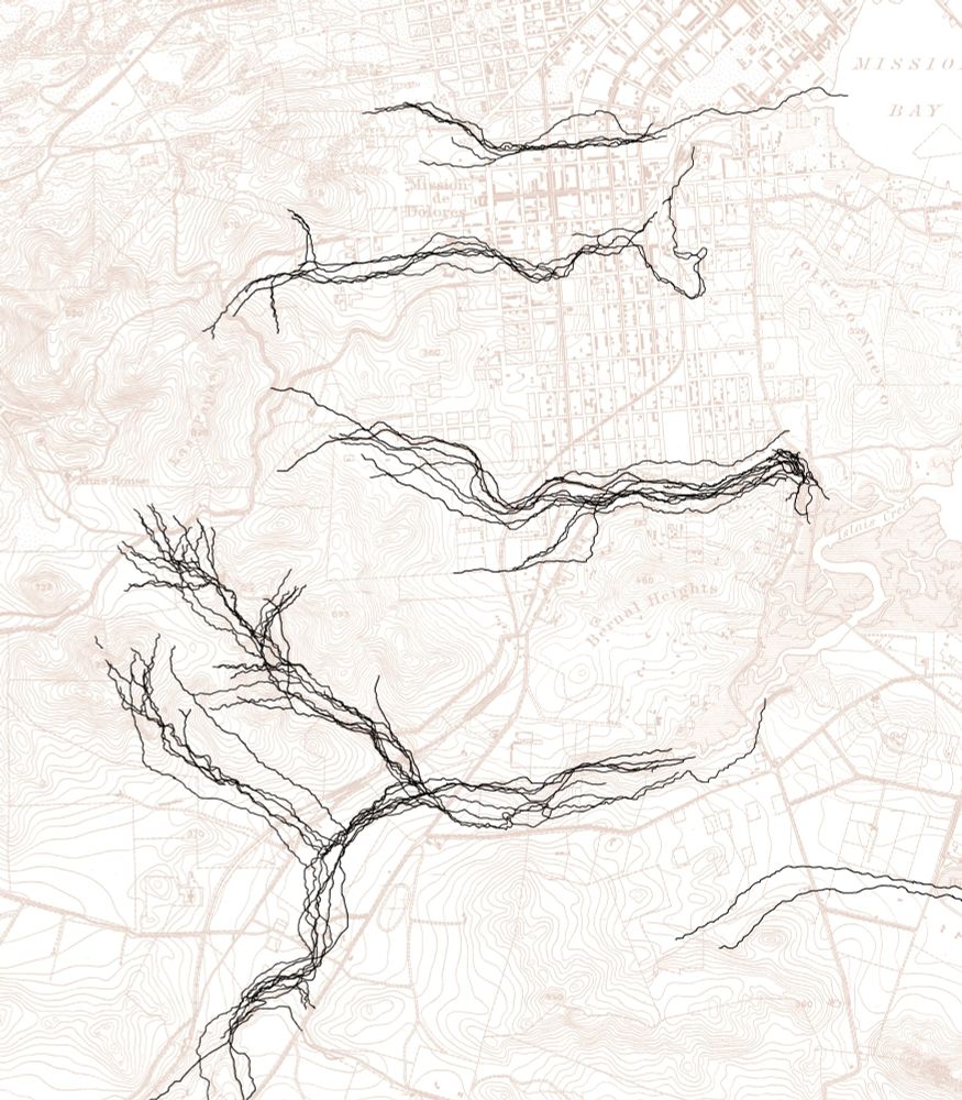
Why I really wanted to get the 1857 and 1869 topographic contours and waterways reconciled correctly, and also why it didn’t really matter if I got them reconciled correctly

September 14, 2025 at 2:21 AM
Why I really wanted to get the 1857 and 1869 topographic contours and waterways reconciled correctly, and also why it didn’t really matter if I got them reconciled correctly
Ah, for the days of going to the library to look up Sanborn maps on microfilm and then taping the paper copies to the wall to assemble them…

September 9, 2025 at 7:31 AM
Ah, for the days of going to the library to look up Sanborn maps on microfilm and then taping the paper copies to the wall to assemble them…
Just found that! Thank you!
This is the page in question: www.loc.gov/resource/g43...
The contours make it look like water should keep flowing southeastward from the "2383" gap, but instead the map shows it turning south on Douglas or perhaps Ord.
This is the page in question: www.loc.gov/resource/g43...
The contours make it look like water should keep flowing southeastward from the "2383" gap, but instead the map shows it turning south on Douglas or perhaps Ord.

September 9, 2025 at 7:10 AM
Just found that! Thank you!
This is the page in question: www.loc.gov/resource/g43...
The contours make it look like water should keep flowing southeastward from the "2383" gap, but instead the map shows it turning south on Douglas or perhaps Ord.
This is the page in question: www.loc.gov/resource/g43...
The contours make it look like water should keep flowing southeastward from the "2383" gap, but instead the map shows it turning south on Douglas or perhaps Ord.
I was struggling with this one too. It's so convenient later to have the Castro Theater as a visual landmark!
This is what I think we are looking at:
This is what I think we are looking at:

September 9, 2025 at 6:36 AM
I was struggling with this one too. It's so convenient later to have the Castro Theater as a visual landmark!
This is what I think we are looking at:
This is what I think we are looking at:
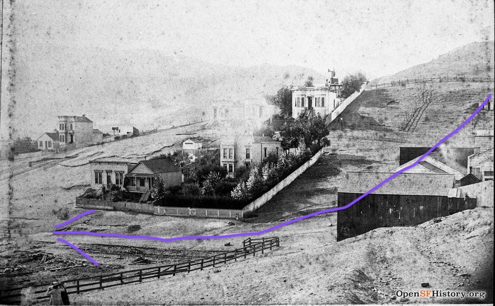
I can't tell if I'm looking at this one right either, but maybe whatever this is in the foreground is the obstruction, and is just not represented well on the map? opensfhistory.org/Display/wnp3...

September 9, 2025 at 6:01 AM
I can't tell if I'm looking at this one right either, but maybe whatever this is in the foreground is the obstruction, and is just not represented well on the map? opensfhistory.org/Display/wnp3...
I can barely even tell what I am looking at here, but I guess maybe I can believe that there was a landslide from Corona Heights or something that would have blocked the southeasterly flow below Douglass and made it run south? opensfhistory.org/Display/wnp3...


September 9, 2025 at 5:34 AM
I can barely even tell what I am looking at here, but I guess maybe I can believe that there was a landslide from Corona Heights or something that would have blocked the southeasterly flow below Douglass and made it run south? opensfhistory.org/Display/wnp3...
Amazing picture! But which rock? This whole circled part is Mint Hill in varying degrees of demolition, isn't it? Is there another rock?

September 9, 2025 at 2:28 AM
Amazing picture! But which rock? This whole circled part is Mint Hill in varying degrees of demolition, isn't it? Is there another rock?
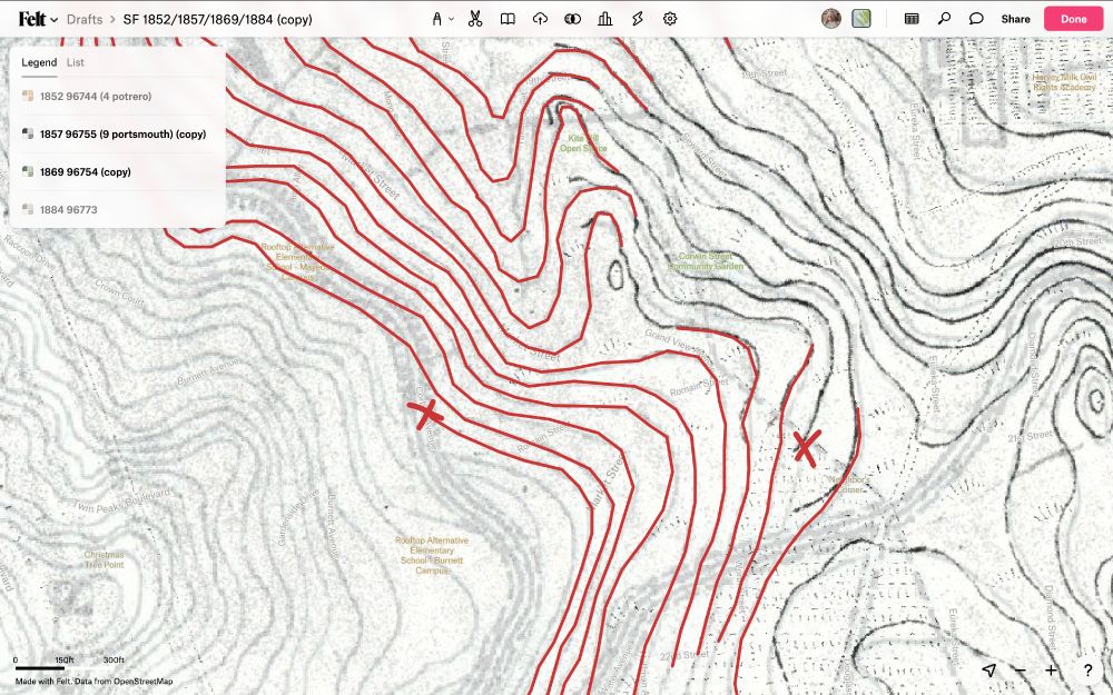
Continuing to grapple with the question of what I really believe about the pre-Bernal Cut, pre-Spring Valley Water Company topography of the Bosworth Undercrossing

September 7, 2025 at 5:56 PM
Continuing to grapple with the question of what I really believe about the pre-Bernal Cut, pre-Spring Valley Water Company topography of the Bosworth Undercrossing
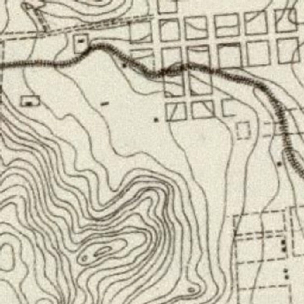
I know where two other topology errors are in the 1869 contours. One more contour leads into Tank Hill from the west than leads out to the south; and another contour vanishes along the north slope of Mount Sutro. Do these cancel each other out somehow?

September 7, 2025 at 3:45 AM
I know where two other topology errors are in the 1869 contours. One more contour leads into Tank Hill from the west than leads out to the south; and another contour vanishes along the north slope of Mount Sutro. Do these cancel each other out somehow?
I finally found the topology error I was puzzling over this morning. An 1869 contour runs into Corbett Road and vanishes, and a corresponding 1857 contour downhill has nothing to connect to near 21st and Douglass
September 7, 2025 at 2:27 AM
I finally found the topology error I was puzzling over this morning. An 1869 contour runs into Corbett Road and vanishes, and a corresponding 1857 contour downhill has nothing to connect to near 21st and Douglass
A Hard Day’s Night (2025)

September 6, 2025 at 8:04 PM
A Hard Day’s Night (2025)
Thanks! I'll check it out.
Also lots of apparently intentional flattening of the east slopes of Corona Heights and Buena Vista Park, but I think the too-far-south location of Mint Hill on the 1869 map is just an error
Also lots of apparently intentional flattening of the east slopes of Corona Heights and Buena Vista Park, but I think the too-far-south location of Mint Hill on the 1869 map is just an error

September 6, 2025 at 6:12 PM
Thanks! I'll check it out.
Also lots of apparently intentional flattening of the east slopes of Corona Heights and Buena Vista Park, but I think the too-far-south location of Mint Hill on the 1869 map is just an error
Also lots of apparently intentional flattening of the east slopes of Corona Heights and Buena Vista Park, but I think the too-far-south location of Mint Hill on the 1869 map is just an error
I'm thinking the changes in Noe Valley are probably intentional grading

September 6, 2025 at 5:45 PM
I'm thinking the changes in Noe Valley are probably intentional grading
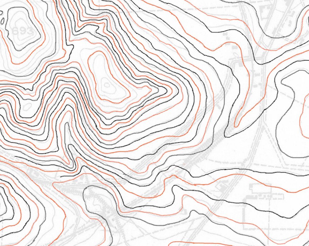
Dear self, IT DOESN'T MATTER. You do not actually need to completely and correctly reconcile the 1857 topographic contours with the 1869 contours

September 6, 2025 at 4:46 PM
Dear self, IT DOESN'T MATTER. You do not actually need to completely and correctly reconcile the 1857 topographic contours with the 1869 contours
On the freehand topic: the draft of the 1853 map suggests that what they were working from was sets of points with equal elevation gain intervals, along a series of straightish lines on the ground, and that the contours connecting them were estimated by eye. Mission Creek not included unfortunately

August 31, 2025 at 9:04 PM
On the freehand topic: the draft of the 1853 map suggests that what they were working from was sets of points with equal elevation gain intervals, along a series of straightish lines on the ground, and that the contours connecting them were estimated by eye. Mission Creek not included unfortunately
And why *didn't* the San Jose Road follow the Bernal Cut route in 1850 to 1852? What made it better to follow what now seems like a more awkward hillside route? What was different by 1856?

August 31, 2025 at 8:12 PM
And why *didn't* the San Jose Road follow the Bernal Cut route in 1850 to 1852? What made it better to follow what now seems like a more awkward hillside route? What was different by 1856?
What I'm imagining is that the north end of the Bernal Cut more or less corresponds to natural drainage, but that the south end cuts perpendicularly across a natural southeastern flow near Milton and Cuvier Streets. Does that seem believable?
August 31, 2025 at 4:33 AM
What I'm imagining is that the north end of the Bernal Cut more or less corresponds to natural drainage, but that the south end cuts perpendicularly across a natural southeastern flow near Milton and Cuvier Streets. Does that seem believable?
I'm not sure it's any better now, but at least less of the error is mine. Anchor points at 16th and Dolores and at the confluence below Glen Park or at Castro and Chenery
August 24, 2025 at 9:52 PM
I'm not sure it's any better now, but at least less of the error is mine. Anchor points at 16th and Dolores and at the confluence below Glen Park or at Castro and Chenery
It turns out that bodies of water do not stay put from one observation to the next

August 24, 2025 at 5:47 PM
It turns out that bodies of water do not stay put from one observation to the next