


Ellen Prager, PhD
@elprager.bsky.social
Marine and earth scientist, nature lover, author, aquanaut, on-air expert, consultant, and passionate about science communication
Warmer atmosphere holds more moisture = more intense rains. Warmer ocean means more heat to fuel hurricane intensification. Media coverage of these stories needs to include CLIMATE CHANGE. It may not be you today that is impacted, but it might be you tomorrow. #1 reduce emissions!🧪🌀🌧️


October 27, 2025 at 3:48 PM
Warmer atmosphere holds more moisture = more intense rains. Warmer ocean means more heat to fuel hurricane intensification. Media coverage of these stories needs to include CLIMATE CHANGE. It may not be you today that is impacted, but it might be you tomorrow. #1 reduce emissions!🧪🌀🌧️
Very concerned for all on #Jamaica. This is catastrophic. Everyone I know, even in sturdy structures, that have been through a major hurricane said they would never stay through one again. And they did not experience what Jamaica is about to get. Wish we could and were doing more to help!!! 🌀


October 27, 2025 at 3:32 PM
Very concerned for all on #Jamaica. This is catastrophic. Everyone I know, even in sturdy structures, that have been through a major hurricane said they would never stay through one again. And they did not experience what Jamaica is about to get. Wish we could and were doing more to help!!! 🌀
TS #Melissa is becoming better organized. Official NHC forecast has storm intensifying to CAT4 hurricane, moving very slowly. May be catastrophic to #Jamaica with constant intense rainfall, very high winds. @geocollaborate.bsky.social Inform anyone in the region to pay attention and prepare. 🧪🌀🌧️🌬️


October 23, 2025 at 8:32 PM
TS #Melissa is becoming better organized. Official NHC forecast has storm intensifying to CAT4 hurricane, moving very slowly. May be catastrophic to #Jamaica with constant intense rainfall, very high winds. @geocollaborate.bsky.social Inform anyone in the region to pay attention and prepare. 🧪🌀🌧️🌬️
October 14, 2025 at 3:01 PM
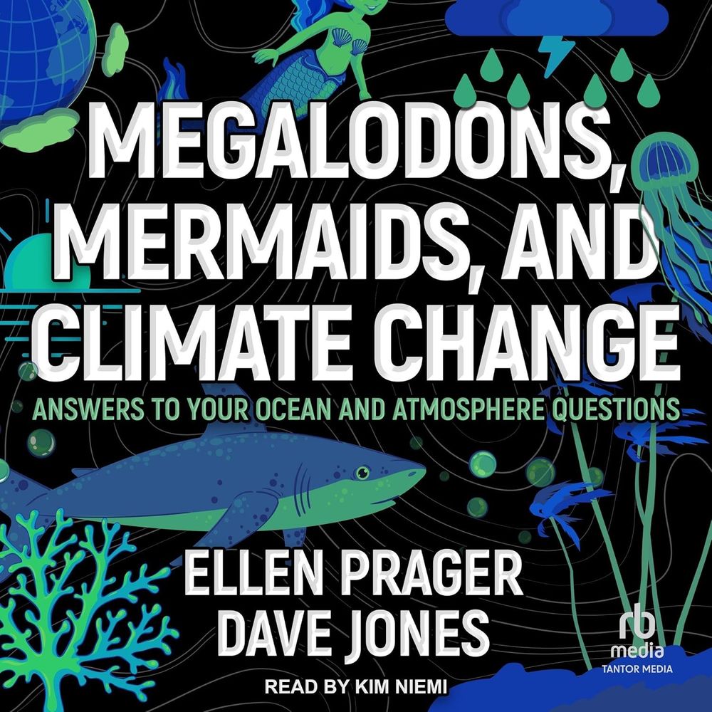
It's here or should I say hear! The Audio Book of Megalodons, Mermaids, and Climate Change released today! On sale for subscribers at various outlets. Print or listening, we combat misinformation and bring the fun. Readers call it great, delightful, funny, important and an inspiration! #BookSky 🧪📚🌎

October 7, 2025 at 2:29 PM
It's here or should I say hear! The Audio Book of Megalodons, Mermaids, and Climate Change released today! On sale for subscribers at various outlets. Print or listening, we combat misinformation and bring the fun. Readers call it great, delightful, funny, important and an inspiration! #BookSky 🧪📚🌎
Data is more powerful when shared collaboratively and readily accessible! We are supporting #hurricane aircraft reconnaissance missions so that for the first time flight plans and live tracks can be integrated with a host of disparate #data using GeoCollaborate. To learn more, get in touch! 🧪🌀🌊🌎


September 25, 2025 at 2:39 PM
Data is more powerful when shared collaboratively and readily accessible! We are supporting #hurricane aircraft reconnaissance missions so that for the first time flight plans and live tracks can be integrated with a host of disparate #data using GeoCollaborate. To learn more, get in touch! 🧪🌀🌊🌎
That’s one heck of a weather vane on our neighbor’s house! Fish pond on lockdown and we’ve deployed protection. 😂😂🐟


September 14, 2025 at 9:43 PM
That’s one heck of a weather vane on our neighbor’s house! Fish pond on lockdown and we’ve deployed protection. 😂😂🐟
Yup here she is

September 11, 2025 at 5:01 PM
Yup here she is
Just did a teaser on The Weather Channel for our appearance on Weather Geeks podcast about our book. Our dog, Willow, is such a media hog. She's been on CNN and TWC already. And this morning, she walked in behind our live shot and jumped up on the couch. Going for milk bone sponsorship?

September 11, 2025 at 3:28 PM
Just did a teaser on The Weather Channel for our appearance on Weather Geeks podcast about our book. Our dog, Willow, is such a media hog. She's been on CNN and TWC already. And this morning, she walked in behind our live shot and jumped up on the couch. Going for milk bone sponsorship?
Risk in tourism must be taken seriously by companies/individuals. This posted by John Opie, Iceland, 23 July 2025. People in photo realized what was happening behind them and left. The lava closed in around 10 minutes later and patch of ground disappeared 30 minutes later as lava slowly expanded. 🌋

September 2, 2025 at 6:50 PM
Risk in tourism must be taken seriously by companies/individuals. This posted by John Opie, Iceland, 23 July 2025. People in photo realized what was happening behind them and left. The lava closed in around 10 minutes later and patch of ground disappeared 30 minutes later as lava slowly expanded. 🌋
It's misinformation time again! People saying wind turbines and windmills kill whales. NO!! Scientific evidence and data document this is not true. Please help combat this fake, false, untrue, incorrect, and absurd idea. 🧪🐋

August 27, 2025 at 1:28 PM
It's misinformation time again! People saying wind turbines and windmills kill whales. NO!! Scientific evidence and data document this is not true. Please help combat this fake, false, untrue, incorrect, and absurd idea. 🧪🐋
Okay, more for you science/data geeks from today's briefing. Looking at marine traffic, guess where Hurricane Erin is (hint the big hole) and right after Hurricane Hunters dropped a wave drifter, here's the data!!! @geocollaborate.bsky.social 🧪🌀


August 20, 2025 at 11:49 PM
Okay, more for you science/data geeks from today's briefing. Looking at marine traffic, guess where Hurricane Erin is (hint the big hole) and right after Hurricane Hunters dropped a wave drifter, here's the data!!! @geocollaborate.bsky.social 🧪🌀
Thanks for having us on Weather Geeks! Great conversation about combating misinformation with science and humor. We appreciate what you do and taking the time to talk with us. @booksky.bsky.social linktr.ee/WeatherGeeks...


August 20, 2025 at 5:05 PM
Thanks for having us on Weather Geeks! Great conversation about combating misinformation with science and humor. We appreciate what you do and taking the time to talk with us. @booksky.bsky.social linktr.ee/WeatherGeeks...
Here we go again. Headline "New Worry: Scientists say underwater volcano off Oregon coast could erupt any day". Axial seamount is a well monitored undersea volcano where eruptions pose no threat. Great science bad headline. Photo courtesy of NOAA. 🧪🌋

August 20, 2025 at 1:39 PM
Here we go again. Headline "New Worry: Scientists say underwater volcano off Oregon coast could erupt any day". Axial seamount is a well monitored undersea volcano where eruptions pose no threat. Great science bad headline. Photo courtesy of NOAA. 🧪🌋
Rip Currents form as waves pile water up on a beach. In high spots, the water then flows to lower areas along the shore until it reaches a low point where it flows offshore as a narrow fast current. Too fast to swim against. Hurricane Erin is creating dangerous rip currents. Do not go in the water.


August 19, 2025 at 1:36 PM
Rip Currents form as waves pile water up on a beach. In high spots, the water then flows to lower areas along the shore until it reaches a low point where it flows offshore as a narrow fast current. Too fast to swim against. Hurricane Erin is creating dangerous rip currents. Do not go in the water.
Don't need landfall to cause major problems and damage. Dangerous conditions along the east coast coming. Glad to see some areas preparing. Cars lined up to evacuate Hatteras Island due to the expected impact of Hurricane #Erin. Photo NCDOT
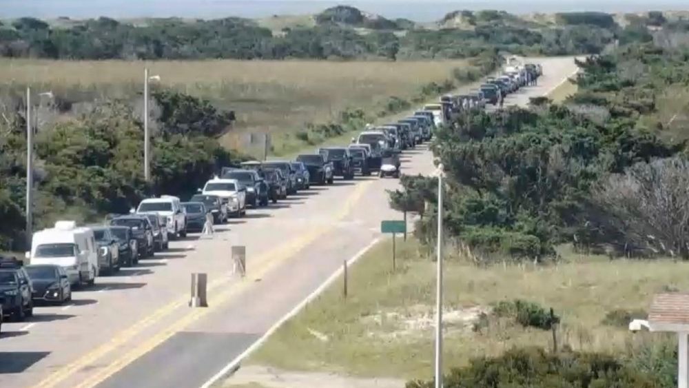
August 18, 2025 at 5:43 PM
Don't need landfall to cause major problems and damage. Dangerous conditions along the east coast coming. Glad to see some areas preparing. Cars lined up to evacuate Hatteras Island due to the expected impact of Hurricane #Erin. Photo NCDOT
So cool, look at this wave drifter data, instrument deployed from Hurricane Hunter aircraft yesterday. Ocean observations help us know conditions, input for models and validation for forecasts. @geocollaborate.bsky.social 🧪🌀🌊

August 18, 2025 at 5:34 PM
So cool, look at this wave drifter data, instrument deployed from Hurricane Hunter aircraft yesterday. Ocean observations help us know conditions, input for models and validation for forecasts. @geocollaborate.bsky.social 🧪🌀🌊
Big waves expected from #Erin, will create dangerous surf, rip currents, flooding and cause coastal erosion. @nhc-atlc.nws-bot.us 48-hour forecast wave heights, wind speeds. Big wind field. Strong wind blowing over large area (fetch)=big waves in the open ocean. At coast, more factors involved. 🧪🌀🌊


August 17, 2025 at 10:25 PM
Big waves expected from #Erin, will create dangerous surf, rip currents, flooding and cause coastal erosion. @nhc-atlc.nws-bot.us 48-hour forecast wave heights, wind speeds. Big wind field. Strong wind blowing over large area (fetch)=big waves in the open ocean. At coast, more factors involved. 🧪🌀🌊
Okay you weather, science and tech geeks out there. Using GeoCollaborate, Dave Jones @geocollaborate.bsky.social showing Hurricane Hunter Miss Piggy flying into #Erin overlay with satellite image in today's briefing. 🧪🌀

August 15, 2025 at 12:13 AM
Okay you weather, science and tech geeks out there. Using GeoCollaborate, Dave Jones @geocollaborate.bsky.social showing Hurricane Hunter Miss Piggy flying into #Erin overlay with satellite image in today's briefing. 🧪🌀
Research cruise turns into critical deployment! UNCW deploying wave drifters in partnership with SCRIPPS just in time to monitor conditions due to soon to be #HurricaneErin. NOAA Hurricane Hunters arrived in Barbados (see flight track in GeoCollaborate), next getting ready to fly into Erin. 🧪🌀


August 13, 2025 at 9:02 PM
Research cruise turns into critical deployment! UNCW deploying wave drifters in partnership with SCRIPPS just in time to monitor conditions due to soon to be #HurricaneErin. NOAA Hurricane Hunters arrived in Barbados (see flight track in GeoCollaborate), next getting ready to fly into Erin. 🧪🌀
Woohoo, Audiobook will be available October 7th!!! Even though we didn't get Dwayne The Rock Johnson and Emma Thompson (our choices) to voice us, it's still gonna be good. Narrator is excellent. @geocollaborate.bsky.social 🧪📚🌀🌪️🦈🌊🐙⚡
August 1, 2025 at 1:52 PM
Woohoo, Audiobook will be available October 7th!!! Even though we didn't get Dwayne The Rock Johnson and Emma Thompson (our choices) to voice us, it's still gonna be good. Narrator is excellent. @geocollaborate.bsky.social 🧪📚🌀🌪️🦈🌊🐙⚡
Great work NOAA Center for #Tsunami Research at PMEL. Blue dots are the Tsunami Warning Center forecast points that can be compared with tide gauges. Inset shows the comparison between the gauge data at Midway Island (black) and the SIFT model projections (red). (Figure by Vasily Titov)🧪🌊
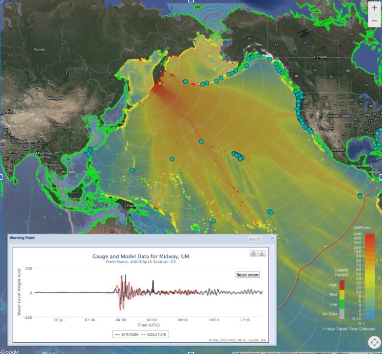
August 1, 2025 at 1:32 PM
Great work NOAA Center for #Tsunami Research at PMEL. Blue dots are the Tsunami Warning Center forecast points that can be compared with tide gauges. Inset shows the comparison between the gauge data at Midway Island (black) and the SIFT model projections (red). (Figure by Vasily Titov)🧪🌊
DART buoys are used to confirm tsunamis, here's a diagram showing how they work and some locations relative to recent M 8.8 quake. Need to maintain these and keep data flowing. Ocean observations keep people safe and informed. Don't let them go away in budget cuts. @geocollaborate.bsky.social 🧪🌊
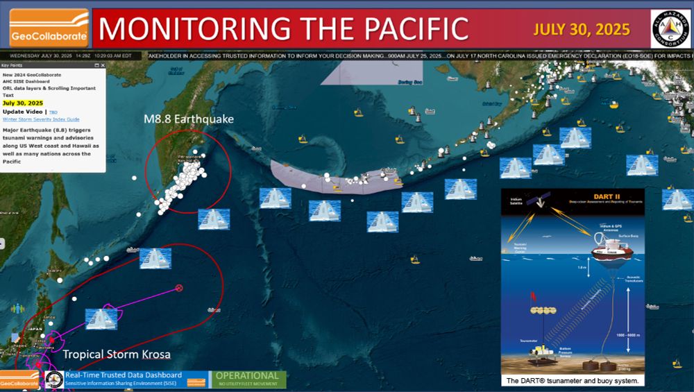
July 30, 2025 at 2:57 PM
DART buoys are used to confirm tsunamis, here's a diagram showing how they work and some locations relative to recent M 8.8 quake. Need to maintain these and keep data flowing. Ocean observations keep people safe and informed. Don't let them go away in budget cuts. @geocollaborate.bsky.social 🧪🌊
Lots going on in the Pacific. StormCenter Communications' GeoCollaborate is monitoring and sharing data across platforms in real-time. @geocollaborate.bsky.social 🧪🌊🌀
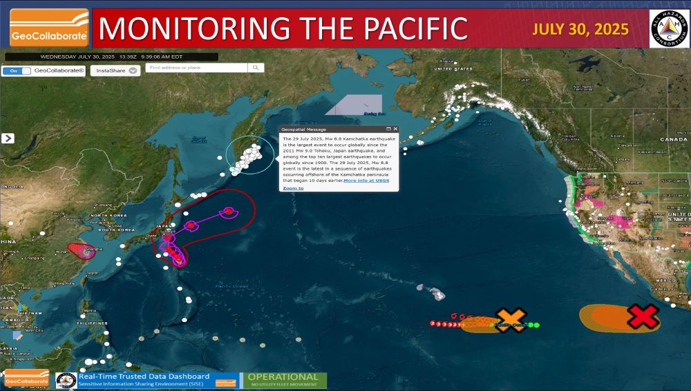
July 30, 2025 at 2:04 PM
Lots going on in the Pacific. StormCenter Communications' GeoCollaborate is monitoring and sharing data across platforms in real-time. @geocollaborate.bsky.social 🧪🌊🌀
Willow is waiting for offers after her latest appearance on tv during this morning's Weather Channel interview. Milkbones or an assisted living for dogs...she's 14 going on 15. 🐕
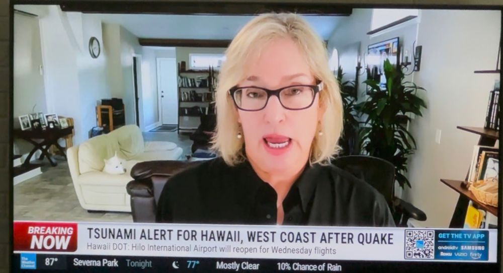
July 30, 2025 at 1:07 PM
Willow is waiting for offers after her latest appearance on tv during this morning's Weather Channel interview. Milkbones or an assisted living for dogs...she's 14 going on 15. 🐕