


Cristian Ionita
@edmapscom.bsky.social
Putting the World on the Map as a Historian, a Cartographer, an Editor...
History, maps, and immigrants: A different U.S. immigration map proposed as a souvenir map from the U.S. Pavilion at the 1958 Brussels Universal and International Exhibition.
#USA #land #people #immigration #immigrants #map #Belgium
#USA #land #people #immigration #immigrants #map #Belgium

October 4, 2025 at 3:47 PM
History, maps, and immigrants: A different U.S. immigration map proposed as a souvenir map from the U.S. Pavilion at the 1958 Brussels Universal and International Exhibition.
#USA #land #people #immigration #immigrants #map #Belgium
#USA #land #people #immigration #immigrants #map #Belgium

History, maps, and wars: An Authentic Plan of the River St. Laurence from Sillery to the Fall of Montmorenci, with the Operations of the Siege of Quebec under the Command of Vice-Admiral Saunders & Major General Wolfe, 1759 (Thomas Jefferys, London, 1759)
#map #carte #Quebec #Canada #Britain #UK
#map #carte #Quebec #Canada #Britain #UK

June 23, 2025 at 6:44 PM

History, maps, and minerals...: An economic map of Iran in the 1980s (from Atlas of the Middle East, New York, Macmillan Publishing Co., 1988)
#map #economy #industries #oil #minerals #Iran #USA #Israel #Palestine
#map #economy #industries #oil #minerals #Iran #USA #Israel #Palestine

June 19, 2025 at 3:40 AM
History, maps, and minerals...: An economic map of Iran in the 1980s (from Atlas of the Middle East, New York, Macmillan Publishing Co., 1988)
#map #economy #industries #oil #minerals #Iran #USA #Israel #Palestine
#map #economy #industries #oil #minerals #Iran #USA #Israel #Palestine

History, maps, and languages: An ethnolinguistic map of Iran

June 17, 2025 at 10:35 PM
History, maps, and languages: An ethnolinguistic map of Iran
#Cuba: ''Why Not?'' (United States and territories: how we grow, a duplicate of an interesting official map recently issued by the U.S. government); a #map published by #American Lithographic Co., #NewYork, 1898.
#maps #history #territorial #expansion #Trump #Greeland #Panama #Canada #Mexico #USA
#maps #history #territorial #expansion #Trump #Greeland #Panama #Canada #Mexico #USA

June 17, 2025 at 3:35 PM
History, #maps, and borders: ''#Persia, Afghanistan and Baluchistan'' (published by The Americana Company, 1904)
#map #geography #war #borders #Iran #Tehran #Baluchistan #Iraq #Palestine #Israel #Arabia #Syria #Turkiye #Armenia #Azerbaijan #Georgia #Russia #Afghanistan #Pakistan #India #China
#map #geography #war #borders #Iran #Tehran #Baluchistan #Iraq #Palestine #Israel #Arabia #Syria #Turkiye #Armenia #Azerbaijan #Georgia #Russia #Afghanistan #Pakistan #India #China

June 16, 2025 at 1:39 AM
History, #maps, and borders: ''#Persia, Afghanistan and Baluchistan'' (published by The Americana Company, 1904)
#map #geography #war #borders #Iran #Tehran #Baluchistan #Iraq #Palestine #Israel #Arabia #Syria #Turkiye #Armenia #Azerbaijan #Georgia #Russia #Afghanistan #Pakistan #India #China
#map #geography #war #borders #Iran #Tehran #Baluchistan #Iraq #Palestine #Israel #Arabia #Syria #Turkiye #Armenia #Azerbaijan #Georgia #Russia #Afghanistan #Pakistan #India #China
History, #maps, & lands: The Territorial Claims of #Persia (Paris Peace Conference, France, 1919)
(for a better version: edmaps.com/html/persia_...)
#map #Iran #history #geography #war #borders #empire #Iraq #Palestine #Israel #Arabia #Syria #Turkiye #Egypt #Armenia #Russia #Azerbaijan #Georgia
(for a better version: edmaps.com/html/persia_...)
#map #Iran #history #geography #war #borders #empire #Iraq #Palestine #Israel #Arabia #Syria #Turkiye #Egypt #Armenia #Russia #Azerbaijan #Georgia

June 15, 2025 at 10:40 PM
History, #maps, and empires: Historical map of #Iran under the Safavi Dynasty in the 16th and 17th centuries (Sahab Geographic & Drafting Inst., #Tehran, 1970)
#map #history #war #Persia #Iraq #Palestine #Israel #Arabia #Syria #Turkiye #Armenia #Azerbaijan #Georgia #Turkmenistan #Afghanistan
#map #history #war #Persia #Iraq #Palestine #Israel #Arabia #Syria #Turkiye #Armenia #Azerbaijan #Georgia #Turkmenistan #Afghanistan

June 15, 2025 at 10:12 PM
History, #maps, and empires: Historical map of #Iran under the Safavi Dynasty in the 16th and 17th centuries (Sahab Geographic & Drafting Inst., #Tehran, 1970)
#map #history #war #Persia #Iraq #Palestine #Israel #Arabia #Syria #Turkiye #Armenia #Azerbaijan #Georgia #Turkmenistan #Afghanistan
#map #history #war #Persia #Iraq #Palestine #Israel #Arabia #Syria #Turkiye #Armenia #Azerbaijan #Georgia #Turkmenistan #Afghanistan

History, #maps, and #immigrants: Where each U.S. state's largest immigrant population was born, 1920 and 2022 (Source: Pew Research Center, 2024)
#map #USA #Mexico #Guatemala #Honduras #Cuba #Canada #India #ElSalvador #Brazil #Jamaica #Britain #UK #Germany #Russia #Italy #Trump #Vance #California
#map #USA #Mexico #Guatemala #Honduras #Cuba #Canada #India #ElSalvador #Brazil #Jamaica #Britain #UK #Germany #Russia #Italy #Trump #Vance #California

June 8, 2025 at 7:31 PM
History, #maps, and nations: The New Europe in 1919 (La Nouvelle #Europe en 1919), a map published by Eiggimann & Co., #Geneva, #Switzerland, 1919.
When #Russia is Muscovy (Moscovie) and #Ukraine, #Belarus (White Ruthenia), and #Armenia are sovereign nations...
#map #history #carte #histoire #WWI
When #Russia is Muscovy (Moscovie) and #Ukraine, #Belarus (White Ruthenia), and #Armenia are sovereign nations...
#map #history #carte #histoire #WWI

June 6, 2025 at 11:45 PM
Ephemeral maps: ''Vast Russian Territory Taken by Germany and Austria'' (The Sun, February 20, 1918)
Eastern Europe, WWI: Territorial situation in February 1918, after the signature of the Treaty of Brest-Litovsk between Ukraine and the Central Powers.
Eastern Europe, WWI: Territorial situation in February 1918, after the signature of the Treaty of Brest-Litovsk between Ukraine and the Central Powers.

June 5, 2025 at 1:39 PM
Ephemeral maps: ''Vast Russian Territory Taken by Germany and Austria'' (The Sun, February 20, 1918)
Eastern Europe, WWI: Territorial situation in February 1918, after the signature of the Treaty of Brest-Litovsk between Ukraine and the Central Powers.
Eastern Europe, WWI: Territorial situation in February 1918, after the signature of the Treaty of Brest-Litovsk between Ukraine and the Central Powers.
History, maps, and nations: A concise #map of #Cyprus and its religious division (from A. Birken, Atlas of #Islam, 2010)
#atlas #history #historical #religion #Christian #Orthodox #Muslim #Jewish #Greece #Greek #Turkiye #Turkish #Britain #UK #British #Famagusta #Larnaca #Limassol #Nikosia #Akrotiri
#atlas #history #historical #religion #Christian #Orthodox #Muslim #Jewish #Greece #Greek #Turkiye #Turkish #Britain #UK #British #Famagusta #Larnaca #Limassol #Nikosia #Akrotiri

June 4, 2025 at 2:45 PM
History, #maps, and letters: A Nazi map illustrating one of the infamous Nuremberg Race Laws (Stuttgart, 1938)
Gothic is used within the German national borders (after the annexation of Austria) and towards the reader, while signs in Roman address the bordering countries. (Waldeck & Leoussi, 2024)
Gothic is used within the German national borders (after the annexation of Austria) and towards the reader, while signs in Roman address the bordering countries. (Waldeck & Leoussi, 2024)

June 3, 2025 at 1:15 PM
History, #maps, and letters: A Nazi map illustrating one of the infamous Nuremberg Race Laws (Stuttgart, 1938)
Gothic is used within the German national borders (after the annexation of Austria) and towards the reader, while signs in Roman address the bordering countries. (Waldeck & Leoussi, 2024)
Gothic is used within the German national borders (after the annexation of Austria) and towards the reader, while signs in Roman address the bordering countries. (Waldeck & Leoussi, 2024)
History, maps, and lands: A map of the State of Palestine (according to The New Atlas of the Arab World, Cairo-New York: American University in Cairo Press, 2010)
#map #Palestine #Egypt #Israel #Jordan #Gaza #Jerusalem #Cisjordan #Hebron #Bethlehem #Ramallah #Nablus #Jenin #Rafah
#map #Palestine #Egypt #Israel #Jordan #Gaza #Jerusalem #Cisjordan #Hebron #Bethlehem #Ramallah #Nablus #Jenin #Rafah

June 1, 2025 at 3:16 AM
History, maps, and lands: A map of the State of Palestine (according to The New Atlas of the Arab World, Cairo-New York: American University in Cairo Press, 2010)
#map #Palestine #Egypt #Israel #Jordan #Gaza #Jerusalem #Cisjordan #Hebron #Bethlehem #Ramallah #Nablus #Jenin #Rafah
#map #Palestine #Egypt #Israel #Jordan #Gaza #Jerusalem #Cisjordan #Hebron #Bethlehem #Ramallah #Nablus #Jenin #Rafah
History, maps, and lands: ''Ethnographical map of Russia in the 19th Century'' (from A. Rambaud, The history of Russia from the earliest times to 1877, vol. 2, New York, J. B. Alden, 1886)
#ethnographic #map #history #territory #expansion #imperialism #Russia #Russians #Ukraine #Ukrainians
#ethnographic #map #history #territory #expansion #imperialism #Russia #Russians #Ukraine #Ukrainians

June 1, 2025 at 12:50 AM
History, maps, and lands: ''Ethnographical map of Russia in the 19th Century'' (from A. Rambaud, The history of Russia from the earliest times to 1877, vol. 2, New York, J. B. Alden, 1886)
#ethnographic #map #history #territory #expansion #imperialism #Russia #Russians #Ukraine #Ukrainians
#ethnographic #map #history #territory #expansion #imperialism #Russia #Russians #Ukraine #Ukrainians
History, maps, and lands: ''Map of the territorial acquisitions of Russia under #Peter the Great and his successors'' (from A. Rambaud, The history of Russia from the earliest times to 1877, vol. 2, New York, J. B. Alden, 1886)
#map #history #territory #expansion #imperialism #Russia #Ukraine
#map #history #territory #expansion #imperialism #Russia #Ukraine

June 1, 2025 at 12:43 AM
History, maps, and lands: ''Map of the territorial acquisitions of Russia under #Peter the Great and his successors'' (from A. Rambaud, The history of Russia from the earliest times to 1877, vol. 2, New York, J. B. Alden, 1886)
#map #history #territory #expansion #imperialism #Russia #Ukraine
#map #history #territory #expansion #imperialism #Russia #Ukraine
History, maps, and lands: ''Map of the formation of the Tsarate of Muscovy'' or ''Russia before #Russia'' (A. Rambaud, A popular #history of Russia: from the earliest times to 1880, vol. 1, #Boston, Estes & Lauriat, 1880)
#map #Ukraine #Estonia #Latvia #Lithuania #Belarus #Kiev #Moscow #Baltic
#map #Ukraine #Estonia #Latvia #Lithuania #Belarus #Kiev #Moscow #Baltic

June 1, 2025 at 12:11 AM
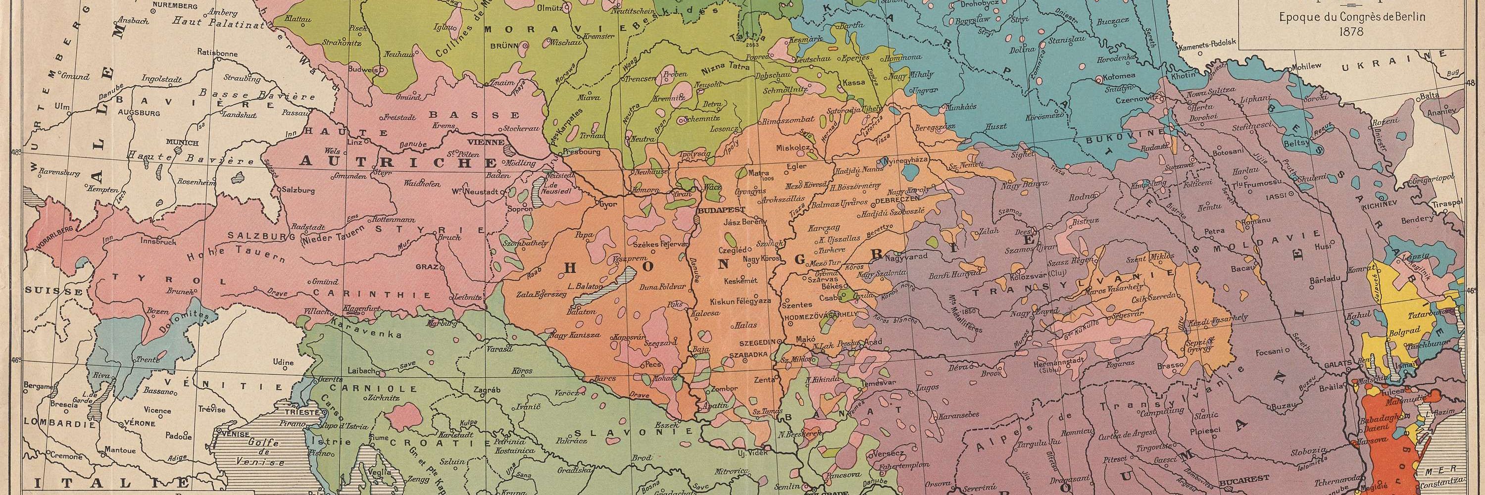
History, peoples, and maps: An ethnographic map of Central Europe (''Peoples of Central Europe'' - H. Thomas, W. Hamm, Modern Europe, Holt, New York, 1934), where all the Czechs are Slovaks and all the Ukrainians are Russians...
#map #ethnographic #Germany #Austria #Poland #Ukraine #Russia
#map #ethnographic #Germany #Austria #Poland #Ukraine #Russia

May 29, 2025 at 3:05 AM
History, maps, and imagination: Australia in the 1830s (according to Thomas John Maslen, The friend of Australia or, a plan for exploring the interior and carrying on a survey of the whole continent of Australia, 1830).
#map #Australia #England #Britain
#map #Australia #England #Britain

May 28, 2025 at 10:07 PM
History, maps, and imagination: Australia in the 1830s (according to Thomas John Maslen, The friend of Australia or, a plan for exploring the interior and carrying on a survey of the whole continent of Australia, 1830).
#map #Australia #England #Britain
#map #Australia #England #Britain
History, wine, and #maps: An #American map of France's wine regions
#map #wine #France #Europe #Macron #Seattle #USA #grapes #sparkling #white #rose #red #dessert #Paris #Bordeaux #champagne #Beaujolais #Sauvignon #Pinot #Burgundy #Chardonnay #Cabernet #Riesling
#map #wine #France #Europe #Macron #Seattle #USA #grapes #sparkling #white #rose #red #dessert #Paris #Bordeaux #champagne #Beaujolais #Sauvignon #Pinot #Burgundy #Chardonnay #Cabernet #Riesling

May 23, 2025 at 3:24 PM
History, wine, and #maps: An #American map of France's wine regions
#map #wine #France #Europe #Macron #Seattle #USA #grapes #sparkling #white #rose #red #dessert #Paris #Bordeaux #champagne #Beaujolais #Sauvignon #Pinot #Burgundy #Chardonnay #Cabernet #Riesling
#map #wine #France #Europe #Macron #Seattle #USA #grapes #sparkling #white #rose #red #dessert #Paris #Bordeaux #champagne #Beaujolais #Sauvignon #Pinot #Burgundy #Chardonnay #Cabernet #Riesling