


Chase Wilson
@dualdoppler.bsky.social
Meteorologist @ Tennessee Valley Weather — I specialize in Radars and Severe Weather Analysis
We just passed the 72nd anniversary of the first tornado to be detected by radar - 4/9/53, in Champaign County, Illinois. This particular tornado was captured by the radar at Willard Airport and was photographed by Don Skaggs, who used a 35mm film camera mounted atop the A-scope

April 10, 2025 at 6:04 AM
We just passed the 72nd anniversary of the first tornado to be detected by radar - 4/9/53, in Champaign County, Illinois. This particular tornado was captured by the radar at Willard Airport and was photographed by Don Skaggs, who used a 35mm film camera mounted atop the A-scope
OTD 9 years ago: I got up close and personal with this multivortex EF-3 tornado between Como and Sardis, MS - this same supercell would later go on to produce an EF-4 near Holly Springs which unfortunately killed 9 people

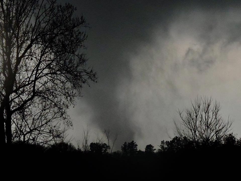
December 23, 2024 at 11:22 PM
OTD 9 years ago: I got up close and personal with this multivortex EF-3 tornado between Como and Sardis, MS - this same supercell would later go on to produce an EF-4 near Holly Springs which unfortunately killed 9 people
I've been in hibernation in this quiet spell of weather, but radar is useful for more than just tornadoes and QLCS'... up in Nome, Alaska, icebergs galore are being tracked in their natural flow up and down the coast using an X-band radar #akwx
December 12, 2024 at 4:08 AM
I've been in hibernation in this quiet spell of weather, but radar is useful for more than just tornadoes and QLCS'... up in Nome, Alaska, icebergs galore are being tracked in their natural flow up and down the coast using an X-band radar #akwx

All sorts of helicopter/plane activity today on the X-band here in S TN. Composite of the last 10 mins beautifully shows aircraft tracks #tnwx

November 27, 2024 at 8:34 PM
All sorts of helicopter/plane activity today on the X-band here in S TN. Composite of the last 10 mins beautifully shows aircraft tracks #tnwx
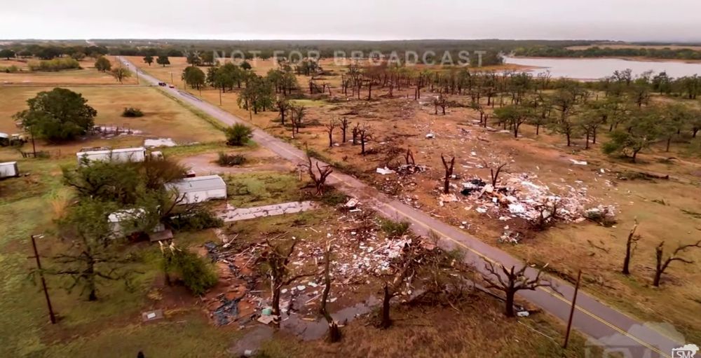
2/16/23 - an otherwise relatively innocuous enhanced risk day in the Tennessee Valley produces a family of EF-0/1 tornadoes within 10km from my teams radar, yielding the best resolution (both spatially & temporally) data we’ve yet gathered of tornadogenesis, featuring vortex holes & all! #tnwx

November 20, 2024 at 12:56 AM
2/16/23 - an otherwise relatively innocuous enhanced risk day in the Tennessee Valley produces a family of EF-0/1 tornadoes within 10km from my teams radar, yielding the best resolution (both spatially & temporally) data we’ve yet gathered of tornadogenesis, featuring vortex holes & all! #tnwx
On the other side of the mtn., Jones Valley school, still full of teachers & children staying for after-school care, was completely destroyed. Fortuitously, 1 of the admins heard the warning & herded the children from their upstairs class into the stairwell. Everyone inside survived. (3/3)

November 15, 2024 at 9:41 PM
On the other side of the mtn., Jones Valley school, still full of teachers & children staying for after-school care, was completely destroyed. Fortuitously, 1 of the admins heard the warning & herded the children from their upstairs class into the stairwell. Everyone inside survived. (3/3)
Fujita personally surveyed this tornado, & sources from NWS Huntsville suggest winds of up to 250mph occurred along Airport Rd., where the worst damage was. Huntsville is my home, & has been my families home for decades. My parents found checks and memorabilia in their yard 9 miles away. (2/3)

November 15, 2024 at 9:41 PM
Fujita personally surveyed this tornado, & sources from NWS Huntsville suggest winds of up to 250mph occurred along Airport Rd., where the worst damage was. Huntsville is my home, & has been my families home for decades. My parents found checks and memorabilia in their yard 9 miles away. (2/3)
OTD '89: Huntsville, AL saw the worst tornado in it's history; the notorious Airport Road F-4. Apartment buildings & entire commercial blocks were eviscerated; duplexes were swept clean from their foundation, & 1000s of cars were thrown and mangled - 21 people died, most of them in cars. (1/3)


November 15, 2024 at 9:41 PM
OTD '89: Huntsville, AL saw the worst tornado in it's history; the notorious Airport Road F-4. Apartment buildings & entire commercial blocks were eviscerated; duplexes were swept clean from their foundation, & 1000s of cars were thrown and mangled - 21 people died, most of them in cars. (1/3)
Archival data of KHTX (left) vs. my team's X-band radar (right) from the Prospect, TN EF-2 on 5/8/24, in which R = Zdr, G = dBZ, B = CC. X-band was scanning the tornadic vortex at 256ft compared to KHTX at 5400ft.
Zdr arc was very intense and omnipresent @ this time near tgen as seen on X-band.
Zdr arc was very intense and omnipresent @ this time near tgen as seen on X-band.

November 14, 2024 at 3:05 AM
Archival data of KHTX (left) vs. my team's X-band radar (right) from the Prospect, TN EF-2 on 5/8/24, in which R = Zdr, G = dBZ, B = CC. X-band was scanning the tornadic vortex at 256ft compared to KHTX at 5400ft.
Zdr arc was very intense and omnipresent @ this time near tgen as seen on X-band.
Zdr arc was very intense and omnipresent @ this time near tgen as seen on X-band.
Recently re-discovered some old photos taken by a Lawrence Co., TN spotter of the April 8th, 1998 "Forgotten F5" in Southern TN.
This tornado fortunately took no lives, but nevertheless was very violent, & was largely usurped in the media by the more well-documented Nashville F3 the same day. #tnwx
This tornado fortunately took no lives, but nevertheless was very violent, & was largely usurped in the media by the more well-documented Nashville F3 the same day. #tnwx


November 8, 2024 at 11:52 PM
Recently re-discovered some old photos taken by a Lawrence Co., TN spotter of the April 8th, 1998 "Forgotten F5" in Southern TN.
This tornado fortunately took no lives, but nevertheless was very violent, & was largely usurped in the media by the more well-documented Nashville F3 the same day. #tnwx
This tornado fortunately took no lives, but nevertheless was very violent, & was largely usurped in the media by the more well-documented Nashville F3 the same day. #tnwx

Comanche dodged a major bullet last night. That sort of scouring and shredding of debris leads me to think this thing with it's relatively narrow vortex could have crept up to violent territory at times #okwx

November 4, 2024 at 5:38 AM
Comanche dodged a major bullet last night. That sort of scouring and shredding of debris leads me to think this thing with it's relatively narrow vortex could have crept up to violent territory at times #okwx
Hurricane #Kristy showing some incredible mesovort action, as well as more of those wispy spiraling cloud features in the eye this afternoon
October 24, 2024 at 5:54 PM
Hurricane #Kristy showing some incredible mesovort action, as well as more of those wispy spiraling cloud features in the eye this afternoon
Harry Weinmans tornado/TDS frequency data shown at SLS also by proxy shows an issue my team is working to solve - the radar gaps in CONUS. Ours in the Tennessee Valley is currently somewhat covered by our X-band which has warned several tornadoes missed by NEXRAD… but more powerful systems needed


October 22, 2024 at 8:33 PM
Harry Weinmans tornado/TDS frequency data shown at SLS also by proxy shows an issue my team is working to solve - the radar gaps in CONUS. Ours in the Tennessee Valley is currently somewhat covered by our X-band which has warned several tornadoes missed by NEXRAD… but more powerful systems needed
Yeah sure whatever. Why not who cares

October 20, 2024 at 4:16 PM
Yeah sure whatever. Why not who cares
Eastern NM today is probably a setup I'd chase if I lived within 50 miles... As far as Clovis specials are concerned, I reckon I could work with this #nmwx

October 19, 2024 at 4:32 PM
Eastern NM today is probably a setup I'd chase if I lived within 50 miles... As far as Clovis specials are concerned, I reckon I could work with this #nmwx
Another fun day with the battle-proven DOW-6 & welcoming FARM to Dixie Alley (plus, catching up with Josh and Karen is always a real treat)
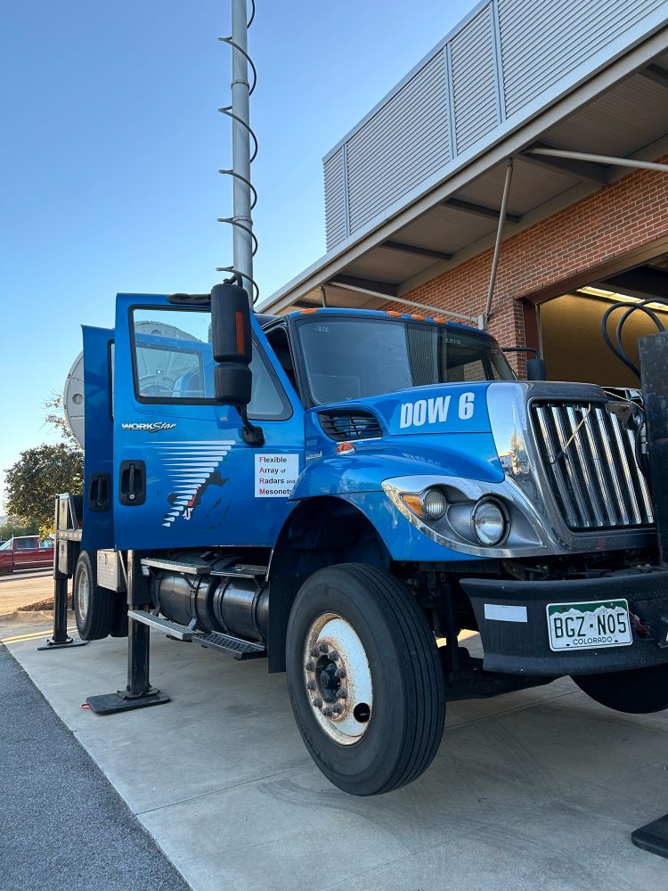
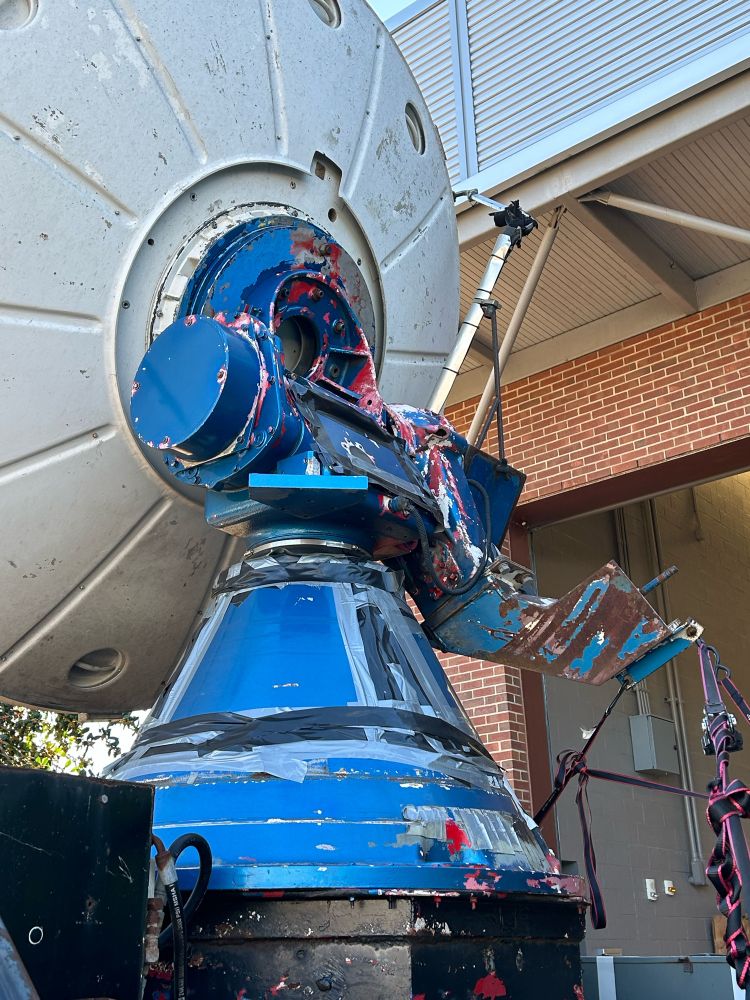
October 19, 2024 at 2:53 AM
Another fun day with the battle-proven DOW-6 & welcoming FARM to Dixie Alley (plus, catching up with Josh and Karen is always a real treat)
Well I'll be... sure enough, a disjointed debris ball and couplet nearly walloped that radar @ 22:35z. Never noticed that

October 17, 2024 at 10:41 PM
Well I'll be... sure enough, a disjointed debris ball and couplet nearly walloped that radar @ 22:35z. Never noticed that
May 10, 2010: OU-PRIME, a C-band operated by OU ARRC, captures tornadogenesis of an EF-4 tornado at high resolution, with winds in this frame approaching 170mph on the forward-right side of the couplet in this scan -

October 17, 2024 at 10:33 PM
May 10, 2010: OU-PRIME, a C-band operated by OU ARRC, captures tornadogenesis of an EF-4 tornado at high resolution, with winds in this frame approaching 170mph on the forward-right side of the couplet in this scan -
I know we’re here to *avoid* Tw*tter, but indulge me in grimacing at the unbelievably obvious timeline suppression that site does when trying to get the word out that I’m over here now… keep in mind, I have 3.6k followers!

October 17, 2024 at 9:38 PM
I know we’re here to *avoid* Tw*tter, but indulge me in grimacing at the unbelievably obvious timeline suppression that site does when trying to get the word out that I’m over here now… keep in mind, I have 3.6k followers!
The Radar dude has made it to Bluesky.
As a gift, I present to y'all the infamous May 3, 1999 scan that sampled winds over 300mph from DOW-3:
As a gift, I present to y'all the infamous May 3, 1999 scan that sampled winds over 300mph from DOW-3:


October 17, 2024 at 7:37 PM
The Radar dude has made it to Bluesky.
As a gift, I present to y'all the infamous May 3, 1999 scan that sampled winds over 300mph from DOW-3:
As a gift, I present to y'all the infamous May 3, 1999 scan that sampled winds over 300mph from DOW-3: