DrSadhbh
drsadhbh.bsky.social
DrSadhbh
@drsadhbh.bsky.social
Mother, geologist, cyclist, photographer, she/her / Lecturer: University of Galway
/ 'Sadhbh' rhymes with 'Five'
Nothing to add apart from the fact that these are the second set of photos I've seen in 2 days that involve volcanic rocks with crocs for scale. Must be the time of year 😀
June 12, 2025 at 9:45 AM
The remainder of the stage stays on the limestone, but with it re-entering an area of drumlins, and crossing the River Boyne twice on every lab of the finishing circuit, the topography becomes undulating, and hard on tired legs.
May 25, 2025 at 5:16 PM
I’m a bit late starting today’s stage (I’d be a DNS!): watching live XCO MTB World Cup racing (on TV) took priority earlier.
Today’s final stage of the Rás takes the peloton from Kildare to Bective, across the rich grasslands (where it’s not Dublin commuter belt) of Counties Kildare and Meath
May 25, 2025 at 5:16 PM
Once the riders cross the Shannon at Portumna the route heads towards another inlier – the Slieve Blooms. However, this time, they will ride over it, with the Cat 1 climb at Wolftrap only 14km from the finish in Mountrath.
May 24, 2025 at 12:37 PM
The higher ground-with different vegetation (conifer forest and upland bog compared to green fields) is underlain by sandstones and shales (brown and green on the geology map) that are older than the limestone and which have been folded up and ‘poke through’ the limestone.
May 24, 2025 at 12:37 PM
Stage 4 of this year’s Rás Tailteann brings the riders back towards the east coast, and in a very general sense, they are following the direction of the Iapetus Suture, the ancient line along which the NW and the SE of Ireland joined up as the Iapetus Ocean closed (~Shannon-Drogheda).
May 24, 2025 at 12:37 PM
These rocks do not dissolve like limestone, so there is surface water here. Water running off the hills disappears underground if it reaches the limestone, generally only emerging again at the coast. A map of rivers in the area illustrates this really well. (from gsi.ie)
May 23, 2025 at 12:12 PM
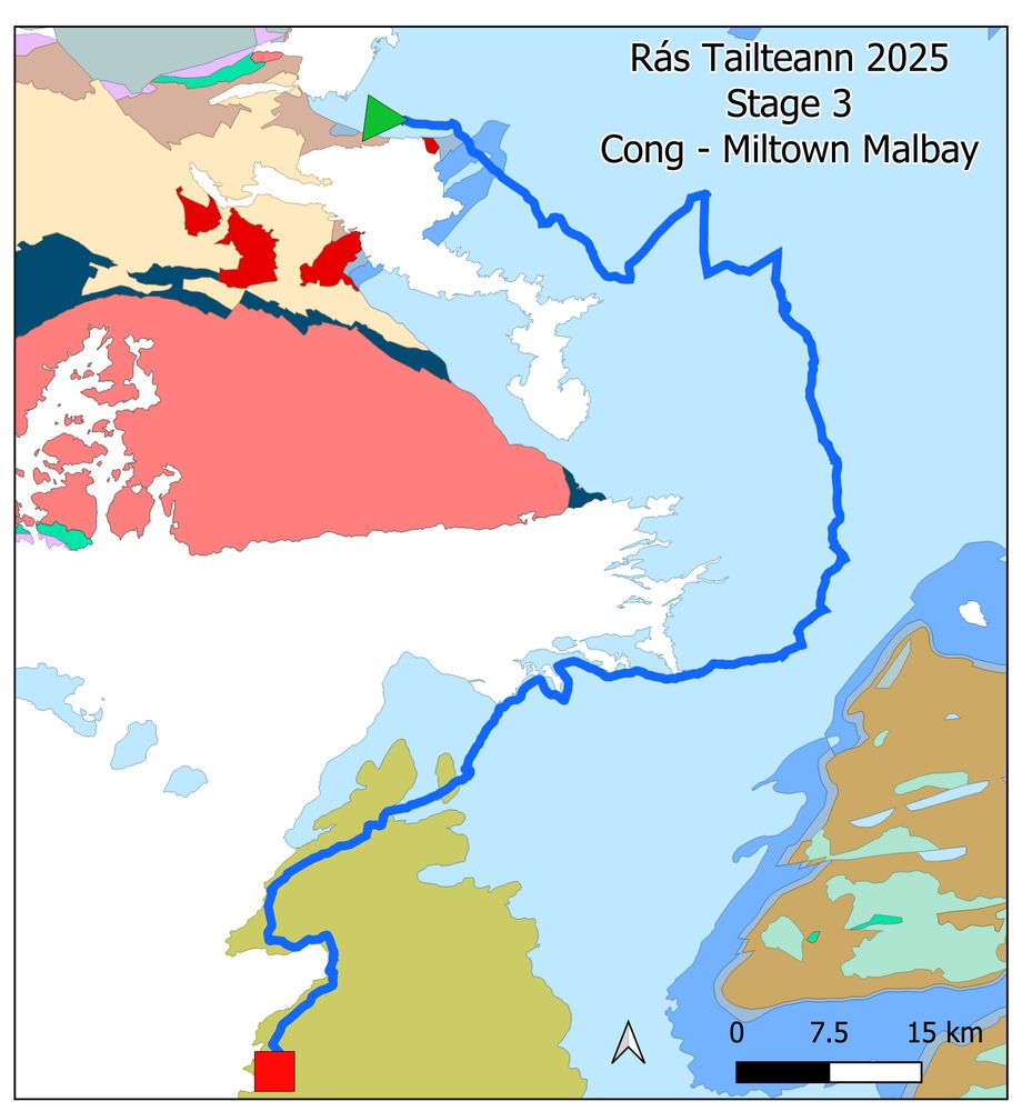
As the route reaches Lisdoonvarna it crosses into the sandstones and shales. These are the rocks that make up the Cliffs of Moher, and the Liscannor flagstone that adorns doorsteps and fireplaces around the country.
May 23, 2025 at 12:12 PM
A feature of the karst landscape of western Ireland in particular are turloughs, or seasonal lakes. These fill and drain through sinkholes – like the drain in a bath tub. They are very special habitats with zones of plants that can withstand varying water levels through the year
May 23, 2025 at 12:12 PM
This results in a karst landscape, and the development of features such as clints and grykes, and caves, with their stalactites and stalagmites. The Burren is a landscape of almost bare rock, or limestone pavement, but between the blocks of limestone lives a rich variety of plants.
May 23, 2025 at 12:12 PM
Limestone is made up of calcite (calcium carbonate) and was deposited in a warm shallow sea. Calcite is the limescale in your kettle: just as you can remove it from your kettle by using acid, slightly acidic rainwater and water soaking through soil will dissolve limestone. tinyurl.com/HClcalcite
May 23, 2025 at 12:12 PM
Stage 3 of this year’s Rás Tailteann starts in the Joyce Country Western Lakes Geopark in Cong, Co Mayo and travels through a large part of the Burren and Cliffs of Moher UNESCO Geopark to Miltown Malbay in Co Clare.
www.joycecountrygeoparkproject.ie
www.burrengeopark.ie
May 23, 2025 at 12:12 PM
The route westwards towards the stage finish in Clifden passes south of the Maamturk Mountains and the Twelve Beds – two mountain ranges divided by the Inagh Valley – a large U-shaped glacial valley.
May 22, 2025 at 9:45 AM
The route then crosses into Connemara, (yellow on map). As with the rocks further north, these were formed as the Iapetus Ocean closed, and include the world famous Connemara Marble. These rocks were folded several times as the tectonic plates collided, producing incredible patterns.
May 22, 2025 at 9:45 AM
After a spin along the beautiful Lough Nafooey, the climb over Aill Dubh (the black cliffs) passes conglomerates that tell of large rivers carrying boulders and cobbles along before dropping them. The cliffs are made of volcanic ash.
joycecountrygeoparkproject.ie/en/attractio...
May 22, 2025 at 9:45 AM
At Finny, pillow basalts are the remains of underwater eruptions of lava on the sea floor during a period of arc volcanism (e.g. as in today’s Japan) – this was during the closing of the Iapetus Ocean.
joycecountrygeoparkproject.ie/en/attractio...
May 22, 2025 at 9:45 AM
The riders are unlikely to be enjoying the scenery, but if they looked west, they’d see some fine examples of glacial corries – scooped by ice out of the mountainsides. joycecountrygeoparkproject.ie/en/attractio...: JCWL Geopark
May 22, 2025 at 9:45 AM
Stage 2 of this year’s Rás Tailteann is the Queen Stage, and will also see the riders encounter some great geology (not a biased opinion at all!).
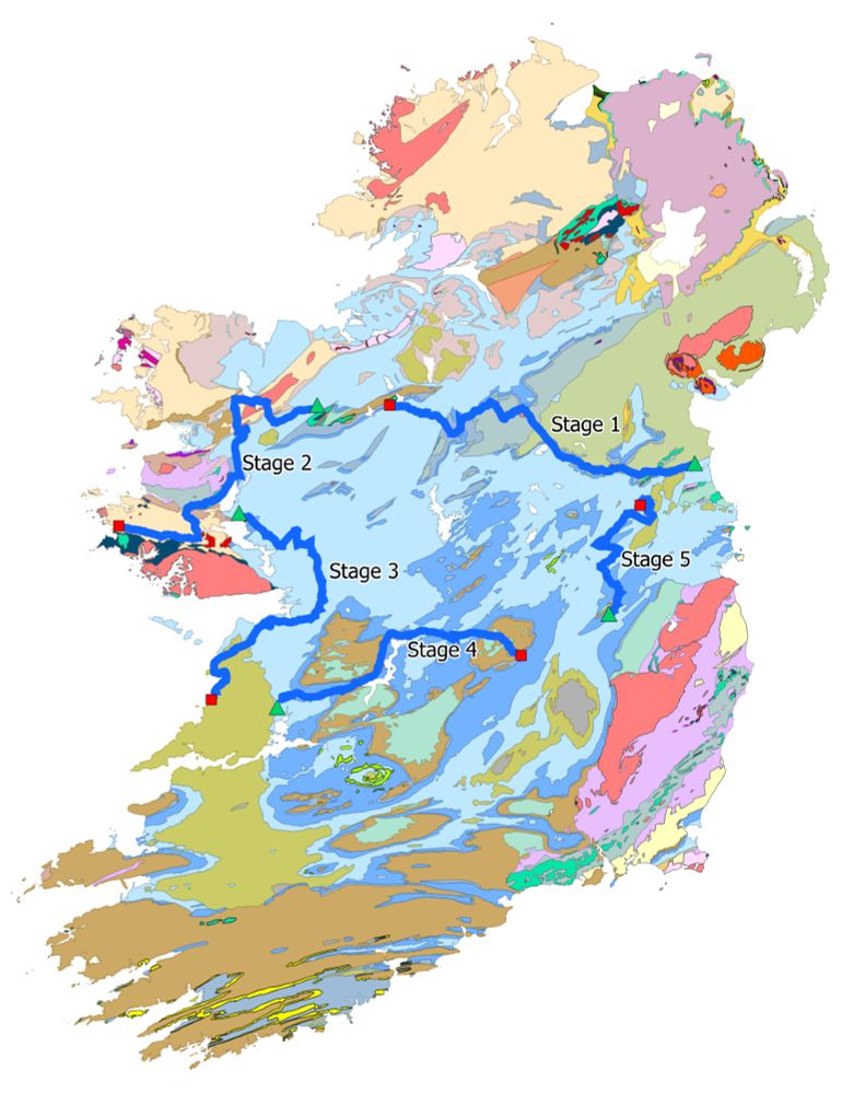
Starting in Charlestown in Co Mayo, the initial route west, brings them off limestone (blue) and onto much older rocks (yellow and red).
May 22, 2025 at 9:45 AM
May 21, 2025 at 4:00 PM
aargh, why didn't my photos show?
May 21, 2025 at 3:58 PM
May 21, 2025 at 3:53 PM
Later in the stage it enters the 'drumlin belt', where lots of lowish elongated rounded hills shaped by glaciers give the landscape a 'basket of eggs' appearance. You can see this well if you use the 'Topography' layer of Google Maps. The GSI (gsi.ie) map outlines the drumlins (different scale). 5/6
May 21, 2025 at 11:25 AM
The rocks in blue formed in shallow tropical seas, and often contain very visible fossils such as corals, crinoids, and shelled organisms called brachiopods. Corals often look like little bicycle wheels - the 'spokes' are internal walls. 3/6
May 21, 2025 at 11:25 AM
Stage 1 of the Rás Tailteann will take the riders from Drogheda to Boyle. The first half of the race very nearly follows a major geological boundary between older sandstones and mudstones (green) and younger limestones (blue). 1/6
May 21, 2025 at 11:25 AM
This is a geological map of Ireland with the 5 stages marked. Different colours on the map = different rock types - so there's plenty of variety as the race crosses the country from east to west and back again. 2/4
May 20, 2025 at 9:41 PM