

Dorian J. Burnette
@djburnette.com
Associate Professor of Atmospheric Science, Department of Earth Sciences, University of Memphis | Historical reconstruction, dendroclimatology, extreme events, storm chasing
Website: http://www.djburnette.com
Website: http://www.djburnette.com
National Hurricane Center's 10 a.m. EDT (1400 UTC) update. #Melissa has intensified with maximum sustained winds of 185 mph and minimum central pressure down to 892 mb.


October 28, 2025 at 2:09 PM
National Hurricane Center's 10 a.m. EDT (1400 UTC) update. #Melissa has intensified with maximum sustained winds of 185 mph and minimum central pressure down to 892 mb.
The Mississippi River at Memphis, TN stage was at -5.44 ft at 3pm CDT today (figure below, downloaded from the dashboard). Forecasts indicate the low water threshold of -8 ft (significant, negative water-related industry/community impacts start) could be breached by the end of the month. 2/2 🧪

September 18, 2025 at 10:01 PM
The Mississippi River at Memphis, TN stage was at -5.44 ft at 3pm CDT today (figure below, downloaded from the dashboard). Forecasts indicate the low water threshold of -8 ft (significant, negative water-related industry/community impacts start) could be breached by the end of the month. 2/2 🧪
Note also in the upper-right corner of that website, there is a link to biodiversity stripes. The biodiversity stripes for the globe from 1970-2020 are below. 2/2 🧪

June 21, 2025 at 4:35 PM
Note also in the upper-right corner of that website, there is a link to biodiversity stripes. The biodiversity stripes for the globe from 1970-2020 are below. 2/2 🧪
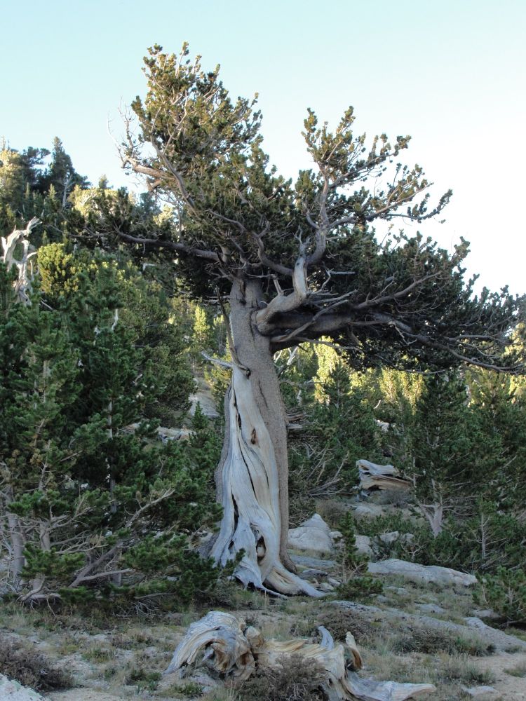
Here's mine for Taxonomy Recognition Day.
Pinus aristata Engelm. (Rocky Mountain bristlecone pine) at Mt. Goliath, Colorado. Photo by my Brazilian colleague, Ana Carolina Barbosa. 2/3 🧪 #NameItToSaveIt
Pinus aristata Engelm. (Rocky Mountain bristlecone pine) at Mt. Goliath, Colorado. Photo by my Brazilian colleague, Ana Carolina Barbosa. 2/3 🧪 #NameItToSaveIt
May 23, 2025 at 7:28 PM
Here's mine for Taxonomy Recognition Day.
Pinus aristata Engelm. (Rocky Mountain bristlecone pine) at Mt. Goliath, Colorado. Photo by my Brazilian colleague, Ana Carolina Barbosa. 2/3 🧪 #NameItToSaveIt
Pinus aristata Engelm. (Rocky Mountain bristlecone pine) at Mt. Goliath, Colorado. Photo by my Brazilian colleague, Ana Carolina Barbosa. 2/3 🧪 #NameItToSaveIt
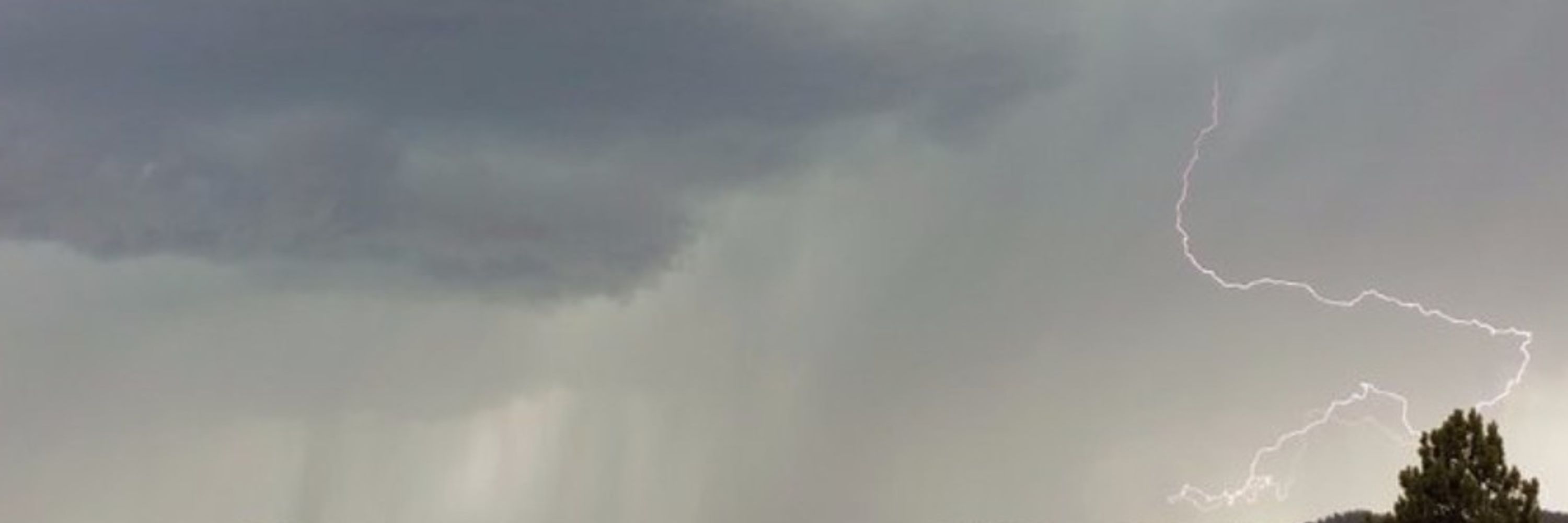
Drifted back to Forrest City after a brief intercept south of Wynne. Saw a wall cloud (below), but couldn't see any rotation. Waiting to see what happens as the cell southwest runs into the cell northeast of Wynne. #arwx

May 20, 2025 at 7:58 PM
Drifted back to Forrest City after a brief intercept south of Wynne. Saw a wall cloud (below), but couldn't see any rotation. Waiting to see what happens as the cell southwest runs into the cell northeast of Wynne. #arwx
Good morning from Enid, OK. I am wearing a certain t-shirt on today's storm chase. Considered a more southern target of Western North TX, but outflow boundary/confluence noted northcentral OK/southcentral KS. Choosing north. Departure imminent.

May 19, 2025 at 4:26 PM
Good morning from Enid, OK. I am wearing a certain t-shirt on today's storm chase. Considered a more southern target of Western North TX, but outflow boundary/confluence noted northcentral OK/southcentral KS. Choosing north. Departure imminent.
Finally got to the supercell in vicinity of Woodward, OK. Still following it. #okwx
www.severestudios.com/storm-chaser...
www.severestudios.com/storm-chaser...

May 19, 2025 at 12:11 AM
Finally got to the supercell in vicinity of Woodward, OK. Still following it. #okwx
www.severestudios.com/storm-chaser...
www.severestudios.com/storm-chaser...
Look what came in my mail recently. 😃

May 1, 2025 at 5:05 PM
Look what came in my mail recently. 😃


April 4, 2025 at 6:20 PM


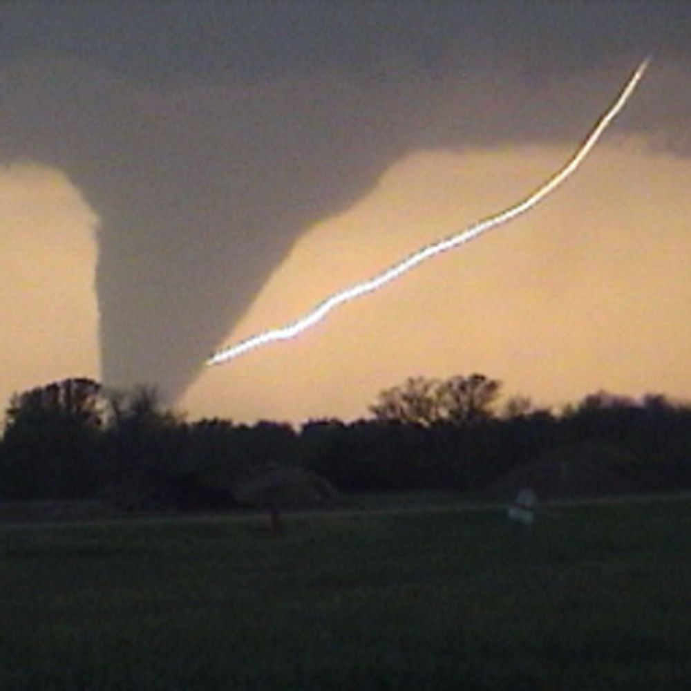
We had one solid intercept on yesterday's storm chase south of Greenway, AR. We observed a wall cloud (left image). No rotation could be observed from our location (~5 miles away), but rising motion was observed. Some cool structure too (right image, wall cloud more embedded in rain). 1/2


March 31, 2025 at 6:19 PM
We had one solid intercept on yesterday's storm chase south of Greenway, AR. We observed a wall cloud (left image). No rotation could be observed from our location (~5 miles away), but rising motion was observed. Some cool structure too (right image, wall cloud more embedded in rain). 1/2
My university has put out a statement on the Office of Management and Budget memo. Screenshot below with alt text. I have redacted the e-mail address in the alt text to limit spam.
Students nervous about student loans, please know your loans are not affected. 🧪
Students nervous about student loans, please know your loans are not affected. 🧪

January 29, 2025 at 4:16 PM
My university has put out a statement on the Office of Management and Budget memo. Screenshot below with alt text. I have redacted the e-mail address in the alt text to limit spam.
Students nervous about student loans, please know your loans are not affected. 🧪
Students nervous about student loans, please know your loans are not affected. 🧪
There is an epilogue at the end of the 13Z Day 1 Convective Outlook--Roger Edwards is retiring. An image capture with alt text is below. See quote post below for a link to the Roger's final outlook. If you are still on X, give @SkyPixWeather a shout out. #wxsky

December 31, 2024 at 3:31 PM
There is an epilogue at the end of the 13Z Day 1 Convective Outlook--Roger Edwards is retiring. An image capture with alt text is below. See quote post below for a link to the Roger's final outlook. If you are still on X, give @SkyPixWeather a shout out. #wxsky
New Bluesky Folks: You may notice that some of us use a domain name for our handle here (see image, my handle circled in red). If you have your own domain, check out the links below to see how to do this.
Bluesky Blog: bsky.social/about/blog/4...
YouTube Video: www.youtube.com/watch?v=lP3O...
Bluesky Blog: bsky.social/about/blog/4...
YouTube Video: www.youtube.com/watch?v=lP3O...

November 12, 2024 at 6:03 PM
New Bluesky Folks: You may notice that some of us use a domain name for our handle here (see image, my handle circled in red). If you have your own domain, check out the links below to see how to do this.
Bluesky Blog: bsky.social/about/blog/4...
YouTube Video: www.youtube.com/watch?v=lP3O...
Bluesky Blog: bsky.social/about/blog/4...
YouTube Video: www.youtube.com/watch?v=lP3O...
ChaseSpectral from KVNX using GR2Analyst. Thanks for sharing these, Sam!

October 30, 2024 at 10:36 PM
ChaseSpectral from KVNX using GR2Analyst. Thanks for sharing these, Sam!
Boom! Scheduled for 9 a.m. CDT (1400 UTC)! Watch Musk ban the butterfly emoji now.

October 30, 2024 at 10:05 PM
Boom! Scheduled for 9 a.m. CDT (1400 UTC)! Watch Musk ban the butterfly emoji now.

What's your "no one but me remembers game?"
Hmmm...let's go with some space flight science fiction:
Hmmm...let's go with some space flight science fiction:

September 15, 2024 at 1:56 PM
What's your "no one but me remembers game?"
Hmmm...let's go with some space flight science fiction:
Hmmm...let's go with some space flight science fiction:
Such a surreal experience! Saw two solar prominences. Batting 1.000 with success in 2017 and 2024. #TotalSolarEclipse


April 8, 2024 at 7:40 PM
Such a surreal experience! Saw two solar prominences. Batting 1.000 with success in 2017 and 2024. #TotalSolarEclipse
Go up to 200 mb and Amarillo is only five knots away from four flags!

February 9, 2024 at 3:22 PM
Go up to 200 mb and Amarillo is only five knots away from four flags!
Preliminary data for the Mississippi River at Memphis, TN suggests a new all-time record low stage of -11.01 ft was set today. Recent daily lows follow a record low that was set in October 2022. These data still need to be verified by the US Army Corps of Engineers, so they are preliminary. 🧪

October 10, 2023 at 7:07 PM
Preliminary data for the Mississippi River at Memphis, TN suggests a new all-time record low stage of -11.01 ft was set today. Recent daily lows follow a record low that was set in October 2022. These data still need to be verified by the US Army Corps of Engineers, so they are preliminary. 🧪
Fair observation and gets right at the heart of the matter about residence time. CFCs have a long one. Back in 2005, the IPCC published the figure below in a special report predicting a slow improvement ozone levels. 1/n

August 28, 2023 at 10:27 PM
Fair observation and gets right at the heart of the matter about residence time. CFCs have a long one. Back in 2005, the IPCC published the figure below in a special report predicting a slow improvement ozone levels. 1/n
Dear authors of that article...

August 28, 2023 at 1:44 PM
Dear authors of that article...