


BREAKING: #Hurricane #Melissa has made landfall as a Category 5 with winds of 185 mph and a pressure of 892 and is tied with the Labor Day Hurricane of 1935 as the strongest hurricane at landfall. Extremely dangerous winds now moving ashore with the eyewall in western Jamaica.

October 28, 2025 at 5:08 PM
BREAKING: #Hurricane #Melissa has made landfall as a Category 5 with winds of 185 mph and a pressure of 892 and is tied with the Labor Day Hurricane of 1935 as the strongest hurricane at landfall. Extremely dangerous winds now moving ashore with the eyewall in western Jamaica.
FREEZE WARNING in effect for areas north and west of the Beltway and a FROST ADVISORY has been issued for Baltimore City and areas along the western shore of the Bay late tonight - Saturday morning. Widespread temps in the 30s expected. #mdwx

October 24, 2025 at 4:37 PM
FREEZE WARNING in effect for areas north and west of the Beltway and a FROST ADVISORY has been issued for Baltimore City and areas along the western shore of the Bay late tonight - Saturday morning. Widespread temps in the 30s expected. #mdwx
FROST ADVISORY in effect tonight for areas north and west of the Beltway. Temps will dip into the mid and upper 30s by Friday morning. It will be as cold Saturday morning for the same areas. #mdwx

October 23, 2025 at 7:48 PM
FROST ADVISORY in effect tonight for areas north and west of the Beltway. Temps will dip into the mid and upper 30s by Friday morning. It will be as cold Saturday morning for the same areas. #mdwx
Isolated strong/severe storms possible late Sunday in the Baltimore area ahead of a cold front. Isolated damaging wind gusts possible associated with a thin line of storms. Timing will be after dark through midnight..quickly moving out Monday morning. #mdwx

October 18, 2025 at 4:41 PM
Isolated strong/severe storms possible late Sunday in the Baltimore area ahead of a cold front. Isolated damaging wind gusts possible associated with a thin line of storms. Timing will be after dark through midnight..quickly moving out Monday morning. #mdwx
Latest update on nor'easter impacts on #Maryland later today through Monday. #mdwx
www.facebook.com/share/p/19yE...
www.facebook.com/share/p/19yE...

October 11, 2025 at 4:52 PM
Latest update on nor'easter impacts on #Maryland later today through Monday. #mdwx
www.facebook.com/share/p/19yE...
www.facebook.com/share/p/19yE...
FROST POTENTIAL UPDATE: Western Howard, Cecil, southern Harford & western Montgomery Co. added to FROST ADVISORY. FREEZE WARNING now in effect for Washington Co. Widespread 30s are expected. #mdwx

October 9, 2025 at 5:15 PM
FROST POTENTIAL UPDATE: Western Howard, Cecil, southern Harford & western Montgomery Co. added to FROST ADVISORY. FREEZE WARNING now in effect for Washington Co. Widespread 30s are expected. #mdwx
RAIN ON THE WAY: A mid-week cold front will bring us the best chance for rain we've seen in a while as early as Tuesday night. The Wednesday morning commute (10/8) will likely be impacted. Rain will taper off quickly by mid to late morning. #mdwx

October 6, 2025 at 4:22 PM
RAIN ON THE WAY: A mid-week cold front will bring us the best chance for rain we've seen in a while as early as Tuesday night. The Wednesday morning commute (10/8) will likely be impacted. Rain will taper off quickly by mid to late morning. #mdwx
FALL CHILL RETURNS MID-WEEK: The coolest air of the season will arrive later this week. The coolest day will be Thursday with highs near 60° and the coldest morning will be Friday morning with lows in the upper 30s and lower 40s. #mdwx

October 6, 2025 at 4:19 PM
FALL CHILL RETURNS MID-WEEK: The coolest air of the season will arrive later this week. The coolest day will be Thursday with highs near 60° and the coldest morning will be Friday morning with lows in the upper 30s and lower 40s. #mdwx
STORMY EVENING POSSIBLE: A few storms...some strong could affect your evening commute. Not a significant threat but could slow you down a bit. Best storm coverage will be around the 4-7 pm timeframe. #mdwx

September 23, 2025 at 2:51 PM
STORMY EVENING POSSIBLE: A few storms...some strong could affect your evening commute. Not a significant threat but could slow you down a bit. Best storm coverage will be around the 4-7 pm timeframe. #mdwx
Scattered severe storms are still expected Saturday afternoon across the region ahead of a cold front. Storms should start firing after 1pm then form into a line as they head east. Wind damage will be the primary threat. #mdwx

September 5, 2025 at 8:27 PM
Scattered severe storms are still expected Saturday afternoon across the region ahead of a cold front. Storms should start firing after 1pm then form into a line as they head east. Wind damage will be the primary threat. #mdwx
DROUGHT UPDATE: The dryness continues across the region as we are back over a 3" rainfall deficit for the year in Baltimore. Rain chances today & Saturday should help...a little. #mdwx

September 4, 2025 at 4:31 PM
DROUGHT UPDATE: The dryness continues across the region as we are back over a 3" rainfall deficit for the year in Baltimore. Rain chances today & Saturday should help...a little. #mdwx
⛈️ Stormy stretch ahead through Saturday ⛈️
👉 Two rounds of storms:
• Later today – severe risk, mainly wind damage
• Saturday – another round, similar threats
• Friday – quiet
Neither day looks like a major outbreak, but since it’s been a while, we’re keeping you alert. #mdwx
👉 Two rounds of storms:
• Later today – severe risk, mainly wind damage
• Saturday – another round, similar threats
• Friday – quiet
Neither day looks like a major outbreak, but since it’s been a while, we’re keeping you alert. #mdwx

September 4, 2025 at 2:57 PM
⛈️ Stormy stretch ahead through Saturday ⛈️
👉 Two rounds of storms:
• Later today – severe risk, mainly wind damage
• Saturday – another round, similar threats
• Friday – quiet
Neither day looks like a major outbreak, but since it’s been a while, we’re keeping you alert. #mdwx
👉 Two rounds of storms:
• Later today – severe risk, mainly wind damage
• Saturday – another round, similar threats
• Friday – quiet
Neither day looks like a major outbreak, but since it’s been a while, we’re keeping you alert. #mdwx
FALL PREVIEW NEXT WEEK: Unseasonably cooler air is on the way. It will feel more like Fall next week with many nights with temps dipping into the 50s. Highs will top out in the upper 70s to near 80. #mdwx

August 21, 2025 at 1:13 AM
FALL PREVIEW NEXT WEEK: Unseasonably cooler air is on the way. It will feel more like Fall next week with many nights with temps dipping into the 50s. Highs will top out in the upper 70s to near 80. #mdwx
Check that....#Erin is now a Cat 5 with winds of 160 and a pressure down to 917 mb. Incredible rate of intensification since last night. #tropics #hurricane

August 16, 2025 at 4:00 PM
Check that....#Erin is now a Cat 5 with winds of 160 and a pressure down to 917 mb. Incredible rate of intensification since last night. #tropics #hurricane
#Erin is just shy of Cat 5 strength with winds of 155 mph. Pressure is down to 923 mb. Erin underwent extreme rapid intensification overnight and will likely reach Cat 5 status shortly. #tropics #hurricane

August 16, 2025 at 3:07 PM
#Erin is just shy of Cat 5 strength with winds of 155 mph. Pressure is down to 923 mb. Erin underwent extreme rapid intensification overnight and will likely reach Cat 5 status shortly. #tropics #hurricane

TROPICAL STORM #ERIN UPDATE: Winds now up to 60. Expected to be a hurricane by Friday. Forecast track shifted a little south & still expected to stay offshore of the Eastern U.S. Still some uncertainty as to how close will get before the turn NE.

August 14, 2025 at 2:49 PM
TROPICAL STORM #ERIN UPDATE: Winds now up to 60. Expected to be a hurricane by Friday. Forecast track shifted a little south & still expected to stay offshore of the Eastern U.S. Still some uncertainty as to how close will get before the turn NE.
FLOOD WATCH in effect for areas along I-95 until 9 PM. Locally heavy rainfall could lead to flash flooding in some areas with rainfall rates of 1-2" per hour possible. Low-end severe threat for wind damage as well. #mdwx

August 13, 2025 at 4:46 PM
FLOOD WATCH in effect for areas along I-95 until 9 PM. Locally heavy rainfall could lead to flash flooding in some areas with rainfall rates of 1-2" per hour possible. Low-end severe threat for wind damage as well. #mdwx
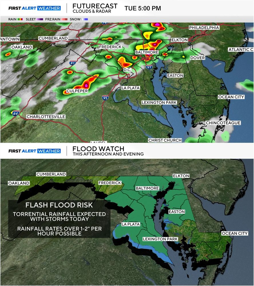
Severe thunderstorms with damaging wind potential and flash flooding are expected later today across the Baltimore Area. Rainfall rates could exceed 2" per hour at times with totals over 5"+ in localized areas that see repeated rounds of storms. #mdwx
July 31, 2025 at 3:00 PM
Severe thunderstorms with damaging wind potential and flash flooding are expected later today across the Baltimore Area. Rainfall rates could exceed 2" per hour at times with totals over 5"+ in localized areas that see repeated rounds of storms. #mdwx
Same old song and dance...different day. ALERT DAY continues WEDNESDAY for high heat/humidity. By Friday & the weekend all of it will be a distant memory as heat relief arrives. #mdwx
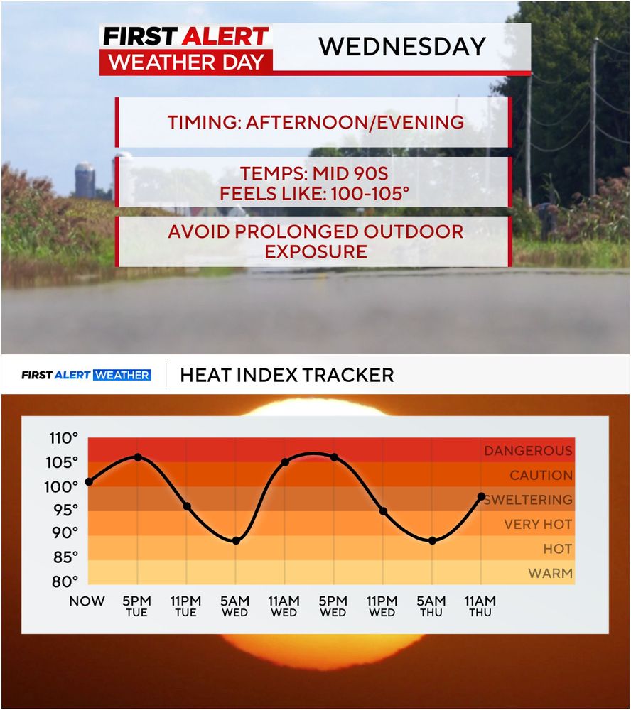
July 29, 2025 at 3:11 PM
Same old song and dance...different day. ALERT DAY continues WEDNESDAY for high heat/humidity. By Friday & the weekend all of it will be a distant memory as heat relief arrives. #mdwx
DROUGHT UPDATE: Much better this week. And after this week's rain the yellow should be gone by next week's update. Baltimore now reporting a surplus in rainfall for the year. #mdwx

July 17, 2025 at 5:02 PM
DROUGHT UPDATE: Much better this week. And after this week's rain the yellow should be gone by next week's update. Baltimore now reporting a surplus in rainfall for the year. #mdwx
DROUGHT UPDATE: The recent rains have helped some but it hasn't been evenly distributed. Some saw a lot more than others. Still running a small deficit in some areas. The rain we saw yesterday and Tuesday should help even more. #mdwx
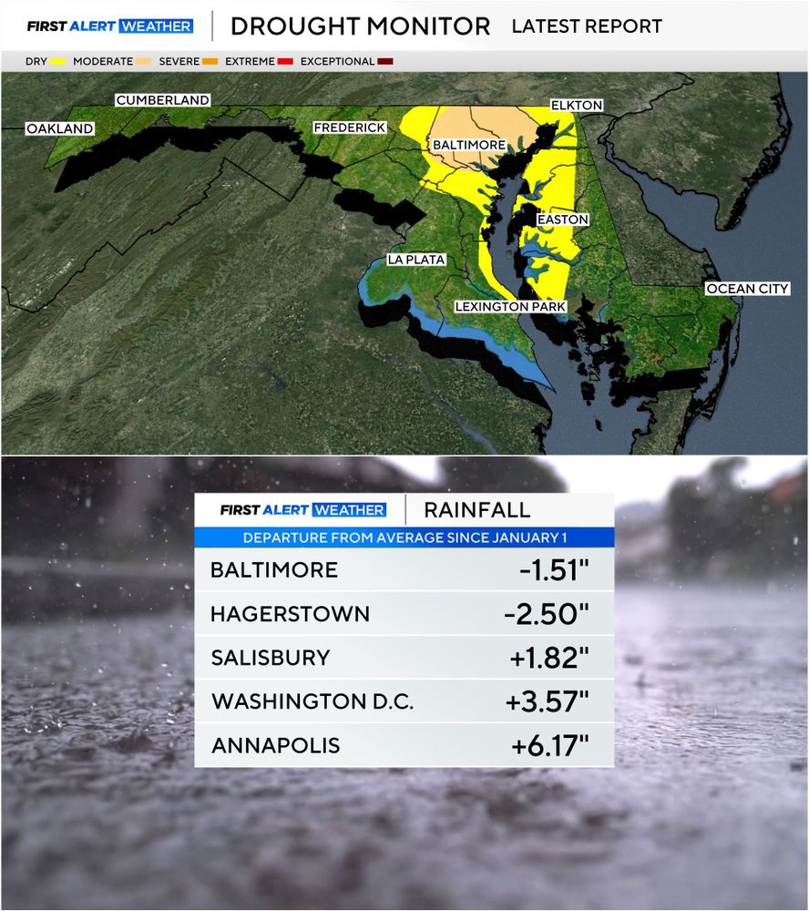
July 10, 2025 at 5:19 PM
DROUGHT UPDATE: The recent rains have helped some but it hasn't been evenly distributed. Some saw a lot more than others. Still running a small deficit in some areas. The rain we saw yesterday and Tuesday should help even more. #mdwx
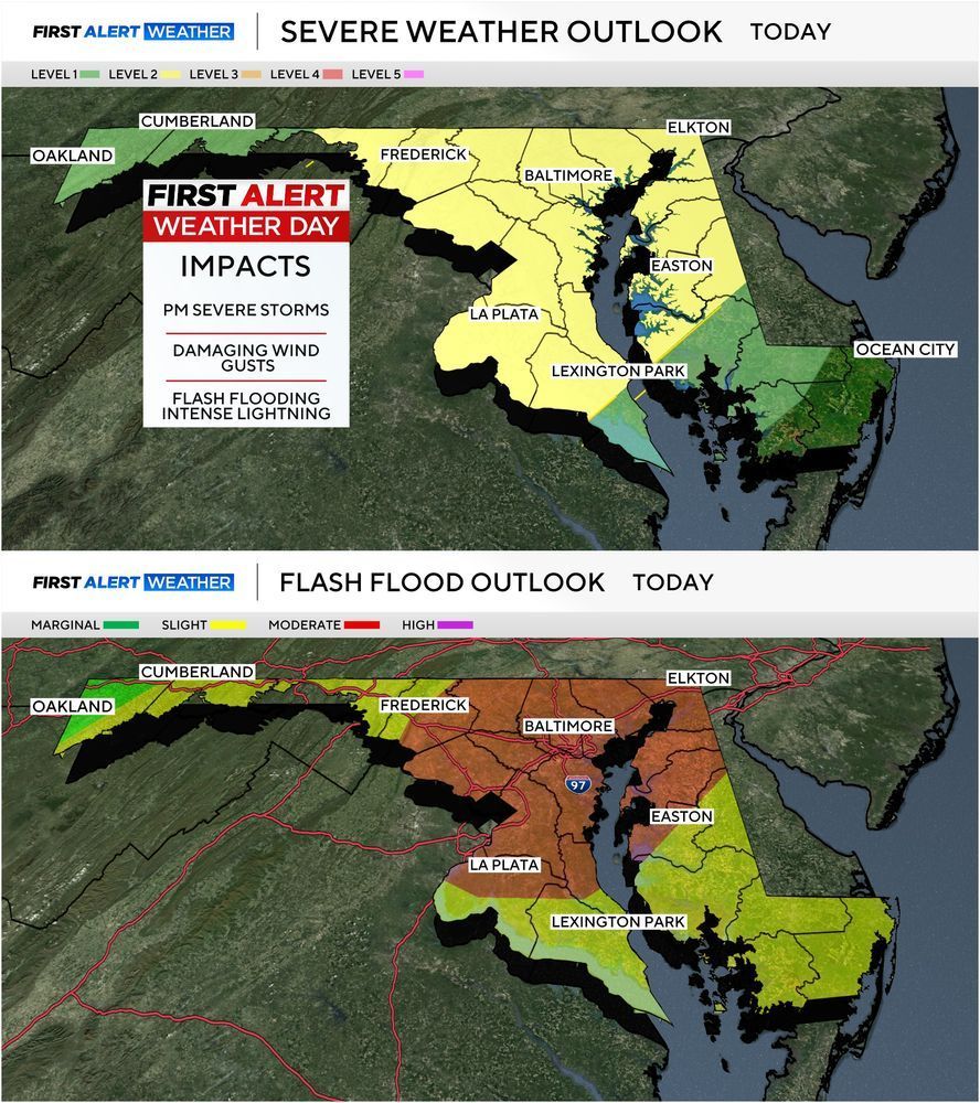
STORMY AFTERNOON/EVENING AHEAD: Severe storms are expected later today with initial development along I-81 by early afternoon with storms marching eastward toward I-95 by the evening rush hour. Storms today will be capable of wind damage, torrential rainfall that could cause flash flooding. #mdwx
July 8, 2025 at 3:42 PM
STORMY AFTERNOON/EVENING AHEAD: Severe storms are expected later today with initial development along I-81 by early afternoon with storms marching eastward toward I-95 by the evening rush hour. Storms today will be capable of wind damage, torrential rainfall that could cause flash flooding. #mdwx
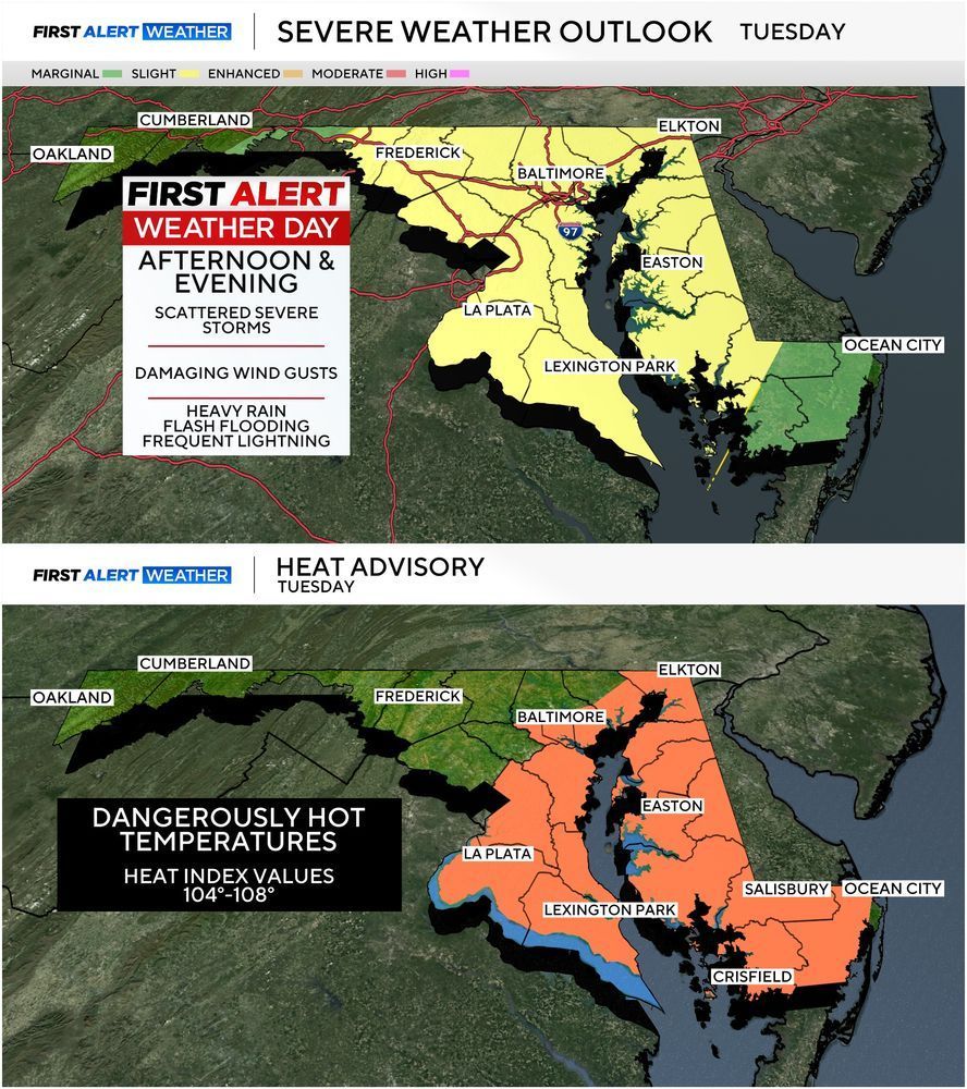
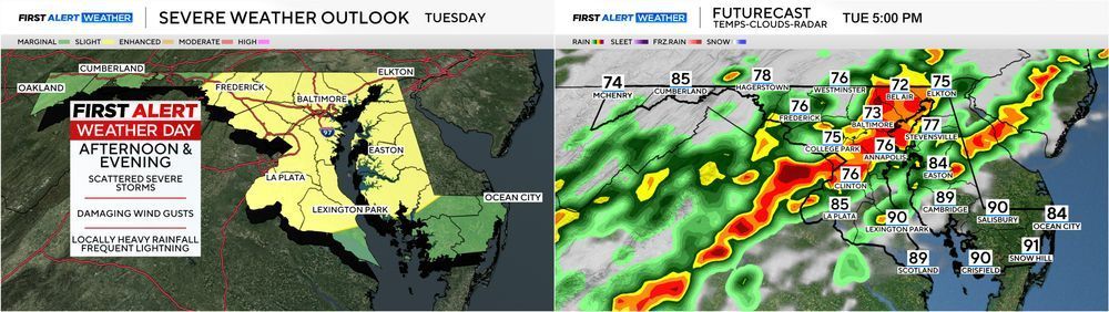
ALERT DAY FOR TUESDAY 7/8: Severe storms are expected across the region Tuesday afternoon/evening as a cold front approaches the area. Heavy rain, gusty winds & frequent lightning are likely. Before storms arrive heat index values will top 100°. #mdwx
July 7, 2025 at 7:33 PM
ALERT DAY FOR TUESDAY 7/8: Severe storms are expected across the region Tuesday afternoon/evening as a cold front approaches the area. Heavy rain, gusty winds & frequent lightning are likely. Before storms arrive heat index values will top 100°. #mdwx
TUESDAY SEVERE STORMS: There is a chance for isolated severe storms this afternoon but the greater threat arrives Tuesday. Timing will be mid to late afternoon through the early evening. Damaging wind gusts the main threat. #mdwx
June 30, 2025 at 4:47 PM
TUESDAY SEVERE STORMS: There is a chance for isolated severe storms this afternoon but the greater threat arrives Tuesday. Timing will be mid to late afternoon through the early evening. Damaging wind gusts the main threat. #mdwx