


Denis Vannier
@denisvannier.bsky.social
Journaliste - Enquête, traitement de données, analyse spatiale et cartographie - Nantes
(Datajournalism, geography & map design)
https://leplan.studio
(Datajournalism, geography & map design)
https://leplan.studio
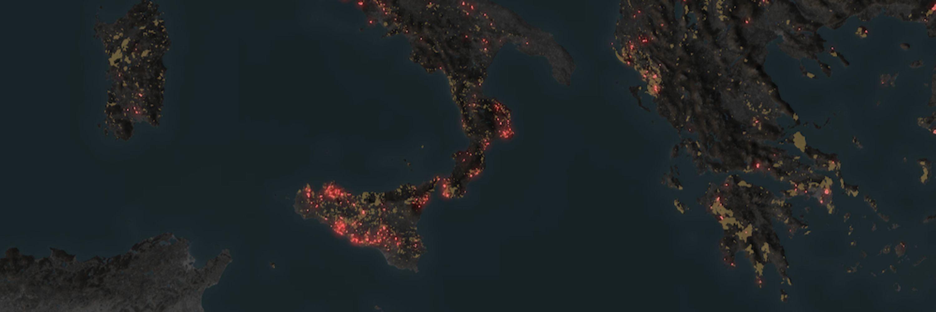
Un petit aperçu du résultat, qui sera publié cet été (ici les permis de construire de nouveaux logements accordés depuis 10 ans à moins de 400m de la côte)

June 13, 2025 at 9:43 AM
Un petit aperçu du résultat, qui sera publié cet été (ici les permis de construire de nouveaux logements accordés depuis 10 ans à moins de 400m de la côte)
🌍 Exhibiting some elevation-based river images made in the style of @geo-coe.bsky.social, in Nantes (France) this month.
January 10, 2025 at 10:42 AM
🌍 Exhibiting some elevation-based river images made in the style of @geo-coe.bsky.social, in Nantes (France) this month.
La cartographie inédite de 2 644 rédactions de médias locaux français est en ligne !
www.ouestmedialab.fr/observatoire...
Un travail d'utilité publique, piloté par Ouest Médialab, qui m'a confié la visualisation des données et la réalisation d'une application (à base de Mapbox.gl @mapbox.com )
www.ouestmedialab.fr/observatoire...
Un travail d'utilité publique, piloté par Ouest Médialab, qui m'a confié la visualisation des données et la réalisation d'une application (à base de Mapbox.gl @mapbox.com )
December 13, 2024 at 12:26 PM
La cartographie inédite de 2 644 rédactions de médias locaux français est en ligne !
www.ouestmedialab.fr/observatoire...
Un travail d'utilité publique, piloté par Ouest Médialab, qui m'a confié la visualisation des données et la réalisation d'une application (à base de Mapbox.gl @mapbox.com )
www.ouestmedialab.fr/observatoire...
Un travail d'utilité publique, piloté par Ouest Médialab, qui m'a confié la visualisation des données et la réalisation d'une application (à base de Mapbox.gl @mapbox.com )
Une partie de mon expo « Méandres » au Muséum de Nantes a fini dans mon salon. De gauche à droite : Protaka Ularowskaya (Russie), Pearl River (USA) et Mackenzie River (Canada)


November 25, 2024 at 7:24 AM
Une partie de mon expo « Méandres » au Muséum de Nantes a fini dans mon salon. De gauche à droite : Protaka Ularowskaya (Russie), Pearl River (USA) et Mackenzie River (Canada)
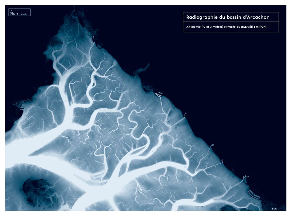
#30DayMapChallenge - Day 6 : Raster
"X-Ray of the Arcachon Bay" (France). DEM from IGN (RGE-Alti 1m)
"X-Ray of the Arcachon Bay" (France). DEM from IGN (RGE-Alti 1m)
November 6, 2024 at 7:03 AM
#30DayMapChallenge - Day 6 : Raster
"X-Ray of the Arcachon Bay" (France). DEM from IGN (RGE-Alti 1m)
"X-Ray of the Arcachon Bay" (France). DEM from IGN (RGE-Alti 1m)
#30DayMapChallenge - Day 3 : Polygons
Housing footprint in Le Tampon, municipality of the french island La Réunion
Housing footprint in Le Tampon, municipality of the french island La Réunion

November 3, 2024 at 10:54 AM
#30DayMapChallenge - Day 3 : Polygons
Housing footprint in Le Tampon, municipality of the french island La Réunion
Housing footprint in Le Tampon, municipality of the french island La Réunion
#30DayMapChallenge - Day 2 : lines
hedgerows destroyed over the last 20 years in Brittany (France) - Aerial Photo Interpretation based on BDOrtho from IGN. Part of an investigation published by @splann.bsky.social : splann.org/enquete/boca...
hedgerows destroyed over the last 20 years in Brittany (France) - Aerial Photo Interpretation based on BDOrtho from IGN. Part of an investigation published by @splann.bsky.social : splann.org/enquete/boca...

November 2, 2024 at 10:37 AM
#30DayMapChallenge - Day 2 : lines
hedgerows destroyed over the last 20 years in Brittany (France) - Aerial Photo Interpretation based on BDOrtho from IGN. Part of an investigation published by @splann.bsky.social : splann.org/enquete/boca...
hedgerows destroyed over the last 20 years in Brittany (France) - Aerial Photo Interpretation based on BDOrtho from IGN. Part of an investigation published by @splann.bsky.social : splann.org/enquete/boca...
Pour @mediacites.bsky.social, j'ai exploré les données des satellites Landsat pour estimer les îlots de chaleur à Nantes Métropole. Avec une trouvaille intéressante sur les conséquences du déménagement du MIN lnkd.in/emGEgzyN
October 31, 2024 at 1:50 PM
Pour @mediacites.bsky.social, j'ai exploré les données des satellites Landsat pour estimer les îlots de chaleur à Nantes Métropole. Avec une trouvaille intéressante sur les conséquences du déménagement du MIN lnkd.in/emGEgzyN
#Lénine, c'est plus de 10 000 statues érigées en un siècle. Démontées en Ukraine, remises en place dans les territoires sous occupation russe, elles sont moins des icônes communistes que les bornes d'un empire. Je les ai cartographié pour la première fois pour Kometa kometarevue.com/cartes/100-a...

January 29, 2024 at 1:51 PM
#Lénine, c'est plus de 10 000 statues érigées en un siècle. Démontées en Ukraine, remises en place dans les territoires sous occupation russe, elles sont moins des icônes communistes que les bornes d'un empire. Je les ai cartographié pour la première fois pour Kometa kometarevue.com/cartes/100-a...