


DeniseG
@denisegutzmer.bsky.social
Keeping tabs on drought impacts for the National Drought Mitigation Center for 10+ years. Views are mine. Be kind.
Mastodon: @DeniseGutzmer@mindly.social
Mastodon: @DeniseGutzmer@mindly.social

November 14, 2025 at 10:06 PM
Drought expanded in parts of the Central and Southern Plains, Southeast and Montana, while easing in the Pacific Northwest and the Northeast. Drought (D1-D4) covers 44.43% of the contiguous US, an uptick of 0.72 points from last week.
#drought #DroughtMonitor 🧪
droughtmonitor.unl.edu/CurrentMap.a...
#drought #DroughtMonitor 🧪
droughtmonitor.unl.edu/CurrentMap.a...


November 13, 2025 at 8:34 PM
Drought expanded in parts of the Central and Southern Plains, Southeast and Montana, while easing in the Pacific Northwest and the Northeast. Drought (D1-D4) covers 44.43% of the contiguous US, an uptick of 0.72 points from last week.
#drought #DroughtMonitor 🧪
droughtmonitor.unl.edu/CurrentMap.a...
#drought #DroughtMonitor 🧪
droughtmonitor.unl.edu/CurrentMap.a...
La Niña is favored to continue into the Northern Hemisphere winter, with a transition to ENSO-neutral most likely in January-March 2026 (61% chance), according to the Climate Prediction Center.
#LaNina #ENSO 🧪
www.cpc.ncep.noaa.gov
#LaNina #ENSO 🧪
www.cpc.ncep.noaa.gov

November 13, 2025 at 4:52 PM
La Niña is favored to continue into the Northern Hemisphere winter, with a transition to ENSO-neutral most likely in January-March 2026 (61% chance), according to the Climate Prediction Center.
#LaNina #ENSO 🧪
www.cpc.ncep.noaa.gov
#LaNina #ENSO 🧪
www.cpc.ncep.noaa.gov
Significant Wildland Fire Potential Outlook for November 2025 shows above normal fire potential for parts of Pennsylvania, New Jersey, West Virginia, Maryland, Georgia, Florida, Alabama, Oklahoma and Texas, and all of Delaware and Hawaii.
#fire #drought
www.nifc.gov/nicc-files/p...
#fire #drought
www.nifc.gov/nicc-files/p...

November 3, 2025 at 7:53 PM
Significant Wildland Fire Potential Outlook for November 2025 shows above normal fire potential for parts of Pennsylvania, New Jersey, West Virginia, Maryland, Georgia, Florida, Alabama, Oklahoma and Texas, and all of Delaware and Hawaii.
#fire #drought
www.nifc.gov/nicc-files/p...
#fire #drought
www.nifc.gov/nicc-files/p...

The US Monthly Drought Outlook shows that drought may persist/develop (brown/yellow) in a large part of the West, swathes of the eastern US and Hawaii. It may improve/be removed (tan/green) in the Pacific Northwest and parts of the Northeast.
#drought 🧪
www.cpc.ncep.noaa.gov/products/exp...
#drought 🧪
www.cpc.ncep.noaa.gov/products/exp...

October 31, 2025 at 8:49 PM
The US Monthly Drought Outlook shows that drought may persist/develop (brown/yellow) in a large part of the West, swathes of the eastern US and Hawaii. It may improve/be removed (tan/green) in the Pacific Northwest and parts of the Northeast.
#drought 🧪
www.cpc.ncep.noaa.gov/products/exp...
#drought 🧪
www.cpc.ncep.noaa.gov/products/exp...
Drought improvement and degradation were mixed in the Northeast, Southeast, Midwest and South with sizable areas of improvement in TX, OK and the Pacific Northwest.
Drought (D1-D4) coverage shrank in the contiguous US to 43.6%, down 2.48 points.
#drought 🧪
droughtmonitor.unl.edu/CurrentMap.a...
Drought (D1-D4) coverage shrank in the contiguous US to 43.6%, down 2.48 points.
#drought 🧪
droughtmonitor.unl.edu/CurrentMap.a...


October 30, 2025 at 4:00 PM
Drought improvement and degradation were mixed in the Northeast, Southeast, Midwest and South with sizable areas of improvement in TX, OK and the Pacific Northwest.
Drought (D1-D4) coverage shrank in the contiguous US to 43.6%, down 2.48 points.
#drought 🧪
droughtmonitor.unl.edu/CurrentMap.a...
Drought (D1-D4) coverage shrank in the contiguous US to 43.6%, down 2.48 points.
#drought 🧪
droughtmonitor.unl.edu/CurrentMap.a...
The US Seasonal Drought Outlook through January 2026 shows that drought may persist/develop (brown/yellow) in the Southwest, South, Southeast and Northeast. Drought may remain/be removed (tan/green) in the Pacific Northwest, Midwest and Hawaii.
#drought 🧪
www.cpc.ncep.noaa.gov/products/exp...
#drought 🧪
www.cpc.ncep.noaa.gov/products/exp...

October 16, 2025 at 3:00 PM
The US Seasonal Drought Outlook through January 2026 shows that drought may persist/develop (brown/yellow) in the Southwest, South, Southeast and Northeast. Drought may remain/be removed (tan/green) in the Pacific Northwest, Midwest and Hawaii.
#drought 🧪
www.cpc.ncep.noaa.gov/products/exp...
#drought 🧪
www.cpc.ncep.noaa.gov/products/exp...
The U.S. Hazards Outlook indicates a risk of rapid onset drought in parts of Oklahoma, Arkansas, Mississippi, Louisiana and Texas from Oct. 17 - 23.
#RapidOnsetDrought #drought #FlashDrought 🧪
www.cpc.ncep.noaa.gov/products/pre...
#RapidOnsetDrought #drought #FlashDrought 🧪
www.cpc.ncep.noaa.gov/products/pre...

October 9, 2025 at 8:13 PM
The U.S. Hazards Outlook indicates a risk of rapid onset drought in parts of Oklahoma, Arkansas, Mississippi, Louisiana and Texas from Oct. 17 - 23.
#RapidOnsetDrought #drought #FlashDrought 🧪
www.cpc.ncep.noaa.gov/products/pre...
#RapidOnsetDrought #drought #FlashDrought 🧪
www.cpc.ncep.noaa.gov/products/pre...
Drought continued to expand in much of the eastern US, while easing in parts of the West and around the confluence of the Ohio and Mississippi rivers. Drought (D1-D4) covers 45.02%, an increase of 2.04 points from last week.
#drought #DroughtMonitor 🧪
droughtmonitor.unl.edu/CurrentMap.a...
#drought #DroughtMonitor 🧪
droughtmonitor.unl.edu/CurrentMap.a...


October 9, 2025 at 7:27 PM
Drought continued to expand in much of the eastern US, while easing in parts of the West and around the confluence of the Ohio and Mississippi rivers. Drought (D1-D4) covers 45.02%, an increase of 2.04 points from last week.
#drought #DroughtMonitor 🧪
droughtmonitor.unl.edu/CurrentMap.a...
#drought #DroughtMonitor 🧪
droughtmonitor.unl.edu/CurrentMap.a...
La Niña conditions are present and favored to persist through December 2025 - February 2026, with a transition to ENSO-neutral likely in January-March 2026 (55% chance).
ENSO Alert System Status: La Niña Advisory
#LaNina #ENSO 🧪
www.cpc.ncep.noaa.gov/products/ana...
ENSO Alert System Status: La Niña Advisory
#LaNina #ENSO 🧪
www.cpc.ncep.noaa.gov/products/ana...

October 9, 2025 at 3:20 PM
La Niña conditions are present and favored to persist through December 2025 - February 2026, with a transition to ENSO-neutral likely in January-March 2026 (55% chance).
ENSO Alert System Status: La Niña Advisory
#LaNina #ENSO 🧪
www.cpc.ncep.noaa.gov/products/ana...
ENSO Alert System Status: La Niña Advisory
#LaNina #ENSO 🧪
www.cpc.ncep.noaa.gov/products/ana...
The calculated soil moisture anomaly map shows incredibly dry soil in the Northeast and parts of the Midwest, Southeast and states along the Gulf.
#soilmoisture #drought 🧪
www.cpc.ncep.noaa.gov/products/Soi...
#soilmoisture #drought 🧪
www.cpc.ncep.noaa.gov/products/Soi...

October 6, 2025 at 7:36 PM
The calculated soil moisture anomaly map shows incredibly dry soil in the Northeast and parts of the Midwest, Southeast and states along the Gulf.
#soilmoisture #drought 🧪
www.cpc.ncep.noaa.gov/products/Soi...
#soilmoisture #drought 🧪
www.cpc.ncep.noaa.gov/products/Soi...
The 8-14 day U.S. Hazards Outlook for October 11-17 shows an area of rapid onset drought risk for southeastern Texas across Louisiana to Mississippi.
#drought #flashdrought #RapidOnsetDroughtRisk 🧪
www.cpc.ncep.noaa.gov/products/pre...
#drought #flashdrought #RapidOnsetDroughtRisk 🧪
www.cpc.ncep.noaa.gov/products/pre...

October 3, 2025 at 8:37 PM
The 8-14 day U.S. Hazards Outlook for October 11-17 shows an area of rapid onset drought risk for southeastern Texas across Louisiana to Mississippi.
#drought #flashdrought #RapidOnsetDroughtRisk 🧪
www.cpc.ncep.noaa.gov/products/pre...
#drought #flashdrought #RapidOnsetDroughtRisk 🧪
www.cpc.ncep.noaa.gov/products/pre...
Drought worsened in parts of Montana, the upper Midwest, South Plains and Southeast, but eased along and south of the Ohio River. Drought (D1-D4) decreased slightly to cover 42.98% of the contiguous US this week, a reduction of 0.43 points.
#drought 🧪
droughtmonitor.unl.edu/CurrentMap.a...
#drought 🧪
droughtmonitor.unl.edu/CurrentMap.a...


October 2, 2025 at 4:42 PM
Drought worsened in parts of Montana, the upper Midwest, South Plains and Southeast, but eased along and south of the Ohio River. Drought (D1-D4) decreased slightly to cover 42.98% of the contiguous US this week, a reduction of 0.43 points.
#drought 🧪
droughtmonitor.unl.edu/CurrentMap.a...
#drought 🧪
droughtmonitor.unl.edu/CurrentMap.a...
Drought has slowed the flow of the Mississippi River, allowing saltwater to move upriver in southeast Louisiana. The location of the saltwater wedge is tracked by the US Army Corps of Engineers.
#drought #MississippiRiver #water #WaterQuality 🧪
www.mvn.usace.army.mil/Missions/Eng...
#drought #MississippiRiver #water #WaterQuality 🧪
www.mvn.usace.army.mil/Missions/Eng...

October 1, 2025 at 1:52 PM
Drought has slowed the flow of the Mississippi River, allowing saltwater to move upriver in southeast Louisiana. The location of the saltwater wedge is tracked by the US Army Corps of Engineers.
#drought #MississippiRiver #water #WaterQuality 🧪
www.mvn.usace.army.mil/Missions/Eng...
#drought #MississippiRiver #water #WaterQuality 🧪
www.mvn.usace.army.mil/Missions/Eng...
The US Monthly Drought Outlook for October shows that drought may persist/develop (brown/yellow) in parts of the West, South Plains, the eastern US, and Hawaii. It may improve/be removed (tan/green) in the Pacific Northwest and Arizona.
#drought 🧪
www.cpc.ncep.noaa.gov/products/exp...
#drought 🧪
www.cpc.ncep.noaa.gov/products/exp...

September 30, 2025 at 7:40 PM
The US Monthly Drought Outlook for October shows that drought may persist/develop (brown/yellow) in parts of the West, South Plains, the eastern US, and Hawaii. It may improve/be removed (tan/green) in the Pacific Northwest and Arizona.
#drought 🧪
www.cpc.ncep.noaa.gov/products/exp...
#drought 🧪
www.cpc.ncep.noaa.gov/products/exp...
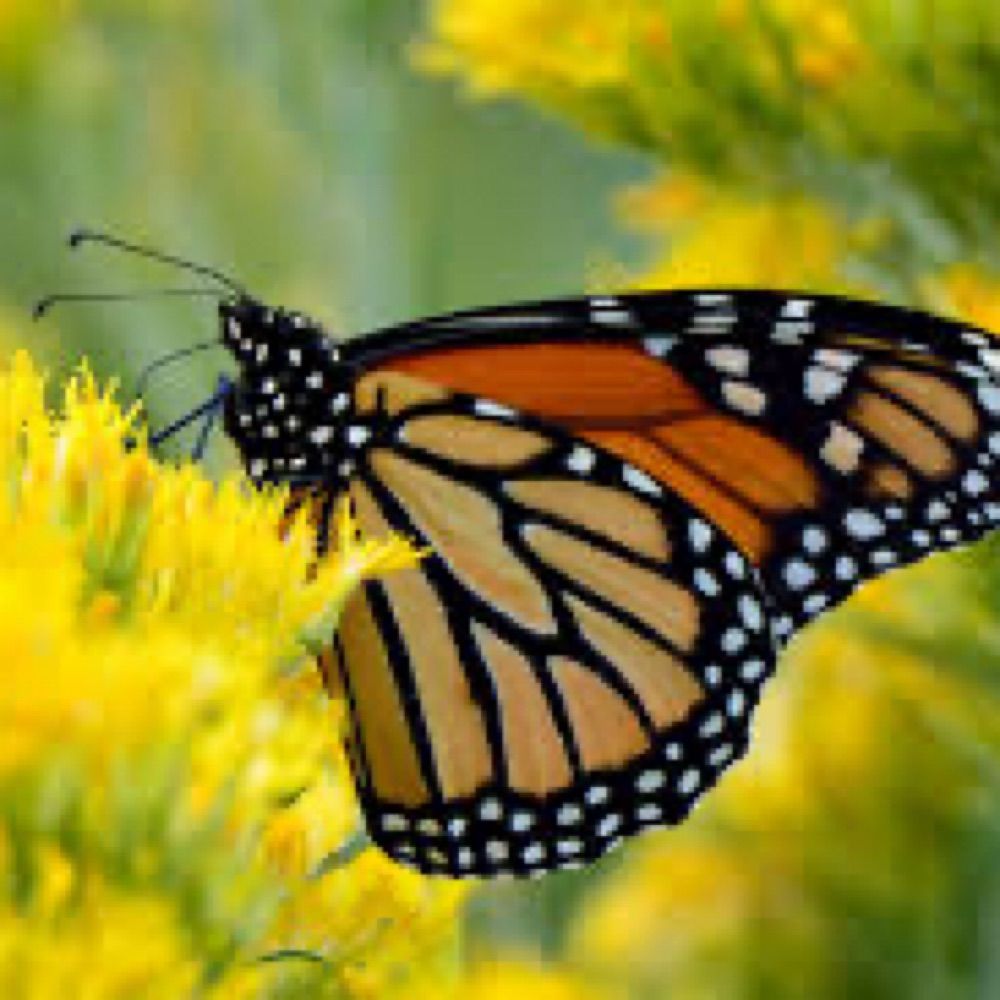
A monarch butterfly just emerged from its chrysalis on my patio. When its wings are dry, it’ll be ready for its journey to Mexico.

September 25, 2025 at 10:37 PM
A monarch butterfly just emerged from its chrysalis on my patio. When its wings are dry, it’ll be ready for its journey to Mexico.
The Days 8-14 U.S. Hazards Outlook indicates rapid onset drought risk for parts of Texas and Louisiana.
#drought #flashdrought 🧪
www.cpc.ncep.noaa.gov/products/pre...
#drought #flashdrought 🧪
www.cpc.ncep.noaa.gov/products/pre...

September 25, 2025 at 7:51 PM
The Days 8-14 U.S. Hazards Outlook indicates rapid onset drought risk for parts of Texas and Louisiana.
#drought #flashdrought 🧪
www.cpc.ncep.noaa.gov/products/pre...
#drought #flashdrought 🧪
www.cpc.ncep.noaa.gov/products/pre...
Many parts of the Eastern U.S. continued to dry out with some mixed areas of improvement across the country. Drought (D1-D4) covered 43.41% of the contiguous U.S., an increase of 2.6 points.
#DroughtMonitor #drought 🧪
droughtmonitor.unl.edu/CurrentMap.a...
#DroughtMonitor #drought 🧪
droughtmonitor.unl.edu/CurrentMap.a...


September 25, 2025 at 4:25 PM
Many parts of the Eastern U.S. continued to dry out with some mixed areas of improvement across the country. Drought (D1-D4) covered 43.41% of the contiguous U.S., an increase of 2.6 points.
#DroughtMonitor #drought 🧪
droughtmonitor.unl.edu/CurrentMap.a...
#DroughtMonitor #drought 🧪
droughtmonitor.unl.edu/CurrentMap.a...
Percent of normal precipitation across the U.S. for the past 30 days. Most of the eastern half of the country received 50% or less of normal rainfall. Areas in red received 25% or less of normal rainfall. Some parts of the Plains and the West got ample precipitation.
🧪
hprcc.unl.edu/maps.php?map...
🧪
hprcc.unl.edu/maps.php?map...

September 24, 2025 at 5:07 PM
Percent of normal precipitation across the U.S. for the past 30 days. Most of the eastern half of the country received 50% or less of normal rainfall. Areas in red received 25% or less of normal rainfall. Some parts of the Plains and the West got ample precipitation.
🧪
hprcc.unl.edu/maps.php?map...
🧪
hprcc.unl.edu/maps.php?map...
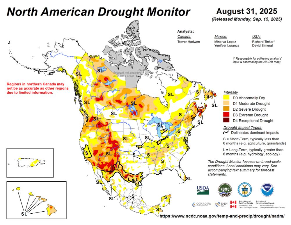
The North American Drought Monitor shows drought in Canada, the U.S. and Mexico at the end of August. Just over 44% of Canada was in drought, 29.2% of the U.S. was affected, and nearly 14% of Mexico was parched.
#drought #NADM #Canada #Mexico 🧪
droughtmonitor.unl.edu/NADM/Home.aspx
#drought #NADM #Canada #Mexico 🧪
droughtmonitor.unl.edu/NADM/Home.aspx

September 23, 2025 at 6:40 PM
The North American Drought Monitor shows drought in Canada, the U.S. and Mexico at the end of August. Just over 44% of Canada was in drought, 29.2% of the U.S. was affected, and nearly 14% of Mexico was parched.
#drought #NADM #Canada #Mexico 🧪
droughtmonitor.unl.edu/NADM/Home.aspx
#drought #NADM #Canada #Mexico 🧪
droughtmonitor.unl.edu/NADM/Home.aspx
The calculated soil moisture ranking percentile map for September 21 shows unusually dry areas in parts of the West, Northeast, Southeast, and Midwest. Areas in the Plains and Michigan's UP are extremely wet.
#drought #SoilMoisture 🧪
www.cpc.ncep.noaa.gov/products/Soi...
#drought #SoilMoisture 🧪
www.cpc.ncep.noaa.gov/products/Soi...

September 23, 2025 at 2:41 PM
The calculated soil moisture ranking percentile map for September 21 shows unusually dry areas in parts of the West, Northeast, Southeast, and Midwest. Areas in the Plains and Michigan's UP are extremely wet.
#drought #SoilMoisture 🧪
www.cpc.ncep.noaa.gov/products/Soi...
#drought #SoilMoisture 🧪
www.cpc.ncep.noaa.gov/products/Soi...
This map shows normal 7-day average streamflow compared to historical streamflow for September 18. The areas in oranges and reds indicate very low streamflows. Notice the large expanses of severe hydrologic drought in the Northeast.
#streamflow #water #drought 🧪
waterwatch.usgs.gov/index.php?r=...
#streamflow #water #drought 🧪
waterwatch.usgs.gov/index.php?r=...

September 19, 2025 at 9:12 PM
This map shows normal 7-day average streamflow compared to historical streamflow for September 18. The areas in oranges and reds indicate very low streamflows. Notice the large expanses of severe hydrologic drought in the Northeast.
#streamflow #water #drought 🧪
waterwatch.usgs.gov/index.php?r=...
#streamflow #water #drought 🧪
waterwatch.usgs.gov/index.php?r=...
Map of real-time streamflow compared to historical streamflow for September 19. The Northeast, Northwest and Hawaii are some parts of the U.S. with record low streamflows. Parts of the Great Plains have much above normal flows.
#streamflow #water #drought 🧪
waterwatch.usgs.gov/index.php?id...
#streamflow #water #drought 🧪
waterwatch.usgs.gov/index.php?id...

September 19, 2025 at 8:30 PM
Map of real-time streamflow compared to historical streamflow for September 19. The Northeast, Northwest and Hawaii are some parts of the U.S. with record low streamflows. Parts of the Great Plains have much above normal flows.
#streamflow #water #drought 🧪
waterwatch.usgs.gov/index.php?id...
#streamflow #water #drought 🧪
waterwatch.usgs.gov/index.php?id...
Soil moisture percentiles across the U.S.
#SoilMoisture #drought 🧪
www.cpc.ncep.noaa.gov/products/Dro...
#SoilMoisture #drought 🧪
www.cpc.ncep.noaa.gov/products/Dro...

September 19, 2025 at 4:51 PM
Soil moisture percentiles across the U.S.
#SoilMoisture #drought 🧪
www.cpc.ncep.noaa.gov/products/Dro...
#SoilMoisture #drought 🧪
www.cpc.ncep.noaa.gov/products/Dro...