


Dave Zaff
@davidzaff.bsky.social
Meteorologist. I like snow, all kinds. Except blizzards. I don’t like blizzards.
The NWS forecast Saturday morning was 50%.

June 16, 2025 at 12:02 AM
The NWS forecast Saturday morning was 50%.
Searching for NOAA in today’s news…


May 8, 2025 at 4:58 PM
Searching for NOAA in today’s news…
Nice little shelf cloud in Western NY this eve. 5/1/25 2249Z.


May 1, 2025 at 10:54 PM
Nice little shelf cloud in Western NY this eve. 5/1/25 2249Z.
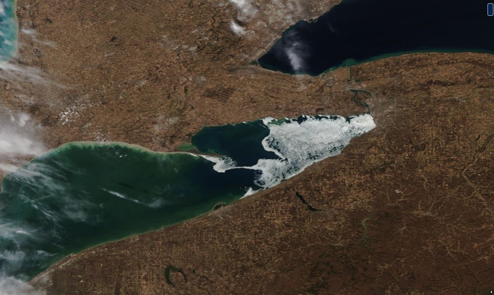
Mesoscale marine effects on Lake Erie.
April 30, 2025 at 6:46 PM
Mesoscale marine effects on Lake Erie.
A rare Day 3 (Tuesday) convective outlook for Western NY and PA. (30-44% chance for severe weather within 25 mi.)
10% chance for significant severe weather, defined in alt text.
10% chance for significant severe weather, defined in alt text.

April 27, 2025 at 8:27 PM
A rare Day 3 (Tuesday) convective outlook for Western NY and PA. (30-44% chance for severe weather within 25 mi.)
10% chance for significant severe weather, defined in alt text.
10% chance for significant severe weather, defined in alt text.
Oneida Lake is showing off it's lake shadow early this afternoon. Not bad for a little guy compared to Lake Ontario.
April 9, 2025 at 4:42 PM
Oneida Lake is showing off it's lake shadow early this afternoon. Not bad for a little guy compared to Lake Ontario.
Partial solar eclipse information for the Buffalo, NY area tomorrow, Mar 29, 2025:
05:29 AM: Partial eclipse begins (below horizon)
07:02 AM: Sunrise
07:05 AM: Maximum eclipse
07:09 AM: Partial eclipse ends
Hardly noticeable, and probably cloudy anyway.
www.timeanddate.com/eclipse/in/u...
05:29 AM: Partial eclipse begins (below horizon)
07:02 AM: Sunrise
07:05 AM: Maximum eclipse
07:09 AM: Partial eclipse ends
Hardly noticeable, and probably cloudy anyway.
www.timeanddate.com/eclipse/in/u...


March 28, 2025 at 2:09 PM
Partial solar eclipse information for the Buffalo, NY area tomorrow, Mar 29, 2025:
05:29 AM: Partial eclipse begins (below horizon)
07:02 AM: Sunrise
07:05 AM: Maximum eclipse
07:09 AM: Partial eclipse ends
Hardly noticeable, and probably cloudy anyway.
www.timeanddate.com/eclipse/in/u...
05:29 AM: Partial eclipse begins (below horizon)
07:02 AM: Sunrise
07:05 AM: Maximum eclipse
07:09 AM: Partial eclipse ends
Hardly noticeable, and probably cloudy anyway.
www.timeanddate.com/eclipse/in/u...
Interesting "ice bridge" on Lake Erie between connecting Long Point, Ontario to PA and NY this afternoon as seen from the NOAA-21 polar orbiter this afternoon. I wouldn't cross it though.
March 21, 2025 at 8:17 PM
Interesting "ice bridge" on Lake Erie between connecting Long Point, Ontario to PA and NY this afternoon as seen from the NOAA-21 polar orbiter this afternoon. I wouldn't cross it though.
Lake Erie ice, now down to 18% coverage is flowing nicely today.
apps.glerl.noaa.gov/coastwatch/w...
geosphere.ssec.wisc.edu#playing:true...;
apps.glerl.noaa.gov/coastwatch/w...
geosphere.ssec.wisc.edu#playing:true...;
March 18, 2025 at 6:08 PM
Lake Erie ice, now down to 18% coverage is flowing nicely today.
apps.glerl.noaa.gov/coastwatch/w...
geosphere.ssec.wisc.edu#playing:true...;
apps.glerl.noaa.gov/coastwatch/w...
geosphere.ssec.wisc.edu#playing:true...;
Bassfield MS. (Summary of PTDS from GR3)

March 15, 2025 at 6:19 PM
Bassfield MS. (Summary of PTDS from GR3)
Lunar eclipse viewing looks pretty good for Western NY with mainly high thin clouds overnight.
Full eclipse begins: 06:26Z (2:26 am EDT)
Maximum Eclipse: 06:58Z (2:58 am EDT)
Full Eclipse ends: 07:31Z (3:31 am EDT)
www.spc.noaa.gov/exper/href/?...
www.timeanddate.com/eclipse/luna...
Full eclipse begins: 06:26Z (2:26 am EDT)
Maximum Eclipse: 06:58Z (2:58 am EDT)
Full Eclipse ends: 07:31Z (3:31 am EDT)
www.spc.noaa.gov/exper/href/?...
www.timeanddate.com/eclipse/luna...
March 13, 2025 at 3:46 PM
Lunar eclipse viewing looks pretty good for Western NY with mainly high thin clouds overnight.
Full eclipse begins: 06:26Z (2:26 am EDT)
Maximum Eclipse: 06:58Z (2:58 am EDT)
Full Eclipse ends: 07:31Z (3:31 am EDT)
www.spc.noaa.gov/exper/href/?...
www.timeanddate.com/eclipse/luna...
Full eclipse begins: 06:26Z (2:26 am EDT)
Maximum Eclipse: 06:58Z (2:58 am EDT)
Full Eclipse ends: 07:31Z (3:31 am EDT)
www.spc.noaa.gov/exper/href/?...
www.timeanddate.com/eclipse/luna...
Some nice hole punches over Western NY this morning. GOES-16 mesosector from 1219-1318Z March 3, 2025.
March 3, 2025 at 2:03 PM
Some nice hole punches over Western NY this morning. GOES-16 mesosector from 1219-1318Z March 3, 2025.
Nice. I was in just about the same spot last spring. I didn't howl though.

February 27, 2025 at 8:07 PM
Nice. I was in just about the same spot last spring. I didn't howl though.
Lake Erie ice cover is down to 81% today. SAR data shows some notable open areas east of Lake Erie Islands and north of Long Point.
www.star.nesdis.noaa.gov/socd/mecb/sa...
apps.glerl.noaa.gov/coastwatch/w...
www.star.nesdis.noaa.gov/socd/mecb/sa...
apps.glerl.noaa.gov/coastwatch/w...


February 26, 2025 at 6:13 PM
Lake Erie ice cover is down to 81% today. SAR data shows some notable open areas east of Lake Erie Islands and north of Long Point.
www.star.nesdis.noaa.gov/socd/mecb/sa...
apps.glerl.noaa.gov/coastwatch/w...
www.star.nesdis.noaa.gov/socd/mecb/sa...
apps.glerl.noaa.gov/coastwatch/w...
Like the classic quote in Princess Bride, “mostly dead is slightly alive”… Just because ‘Lake Erie is mostly ice covered’ doesn’t mean we can’t have lake effect snow.


February 19, 2025 at 5:14 PM
Like the classic quote in Princess Bride, “mostly dead is slightly alive”… Just because ‘Lake Erie is mostly ice covered’ doesn’t mean we can’t have lake effect snow.
Impressive! Ice cover over Lake Erie increased from around 27% on Sunday to near 80% on Wednesday. SAR NCRS does a spectacular job capturing this without cloud interference. #lakeerie
www.star.nesdis.noaa.gov/socd/mecb/sa...
apps.glerl.noaa.gov/coastwatch/w...
www.star.nesdis.noaa.gov/socd/mecb/sa...
apps.glerl.noaa.gov/coastwatch/w...
January 23, 2025 at 12:21 PM
Impressive! Ice cover over Lake Erie increased from around 27% on Sunday to near 80% on Wednesday. SAR NCRS does a spectacular job capturing this without cloud interference. #lakeerie
www.star.nesdis.noaa.gov/socd/mecb/sa...
apps.glerl.noaa.gov/coastwatch/w...
www.star.nesdis.noaa.gov/socd/mecb/sa...
apps.glerl.noaa.gov/coastwatch/w...
Looks like I made it past the 100" mark this week for seasonal snow... 107.3" and counting. Here's my CoCoRaHS seasonal snow summary from 2008-today. It's not an official climatology, but it does roughly match local stats showing this location just above 100"/year.
www.weather.gov/media/erh/ta...
www.weather.gov/media/erh/ta...


January 22, 2025 at 6:34 PM
Looks like I made it past the 100" mark this week for seasonal snow... 107.3" and counting. Here's my CoCoRaHS seasonal snow summary from 2008-today. It's not an official climatology, but it does roughly match local stats showing this location just above 100"/year.
www.weather.gov/media/erh/ta...
www.weather.gov/media/erh/ta...
Here's a dprog/Dt of the ECMWF's Extreme Forecast Index (EFI - shaded) and the Shift of Tails (SOT - black contours) for snowfall. Images start on Wed 00Z Jan 15, 2025, and continue at 24 hr time steps.
January 22, 2025 at 3:37 PM
Here's a dprog/Dt of the ECMWF's Extreme Forecast Index (EFI - shaded) and the Shift of Tails (SOT - black contours) for snowfall. Images start on Wed 00Z Jan 15, 2025, and continue at 24 hr time steps.
It’s time for another dump! 2-4”/hr under an intense lake effect snowband east of Lake Erie.
January 22, 2025 at 12:26 AM
It’s time for another dump! 2-4”/hr under an intense lake effect snowband east of Lake Erie.
Lake Erie ice cover for 1/20/25: 38%. This morning's SAR products show increasing shore ice with more widespread ice building across the lake west of of a line from roughly Rondeau Park Ontario south to Cleveland OH.
apps.glerl.noaa.gov/coastwatch/w...
www.star.nesdis.noaa.gov/socd/mecb/sa...
apps.glerl.noaa.gov/coastwatch/w...
www.star.nesdis.noaa.gov/socd/mecb/sa...

January 21, 2025 at 4:15 PM
Lake Erie ice cover for 1/20/25: 38%. This morning's SAR products show increasing shore ice with more widespread ice building across the lake west of of a line from roughly Rondeau Park Ontario south to Cleveland OH.
apps.glerl.noaa.gov/coastwatch/w...
www.star.nesdis.noaa.gov/socd/mecb/sa...
apps.glerl.noaa.gov/coastwatch/w...
www.star.nesdis.noaa.gov/socd/mecb/sa...
Thundersnow! The strike over Lake Erie was about 17 miles away. Maybe I heard and saw the flash from another one? Oh, and it’s coming’ down hard!

January 21, 2025 at 1:57 AM
Thundersnow! The strike over Lake Erie was about 17 miles away. Maybe I heard and saw the flash from another one? Oh, and it’s coming’ down hard!
Atlanta, GA: ‘It might snow again next Wednesday!’
Western NY: ‘That’s nice.’
Western NY: ‘That’s nice.’


January 18, 2025 at 12:59 PM
Atlanta, GA: ‘It might snow again next Wednesday!’
Western NY: ‘That’s nice.’
Western NY: ‘That’s nice.’
SAR products had some great passes over Lake Erie this morning, offering a nearly complete picture of ice. The NCRS does a better job with ice detail, but colorized wind speed, with GFS wind barbs, also shows ice, albeit with erroneous wind speeds.
www.star.nesdis.noaa.gov/socd/mecb/sa...
www.star.nesdis.noaa.gov/socd/mecb/sa...


January 17, 2025 at 5:22 PM
SAR products had some great passes over Lake Erie this morning, offering a nearly complete picture of ice. The NCRS does a better job with ice detail, but colorized wind speed, with GFS wind barbs, also shows ice, albeit with erroneous wind speeds.
www.star.nesdis.noaa.gov/socd/mecb/sa...
www.star.nesdis.noaa.gov/socd/mecb/sa...
Challenging lake effect snow forecasts next week east of Lake Erie. Ice coverage on 1/16/2025: 35% (mostly west side). Forecasts show a rapid increase as arctic blast moves in. There is a potential for a strong lake effect response with below zero wind chill, but it'll be a battle as ice increases.


January 17, 2025 at 1:18 PM
Challenging lake effect snow forecasts next week east of Lake Erie. Ice coverage on 1/16/2025: 35% (mostly west side). Forecasts show a rapid increase as arctic blast moves in. There is a potential for a strong lake effect response with below zero wind chill, but it'll be a battle as ice increases.
January 7, 2025 at 8:29 PM