


Colin Seftor
@cseftor.bsky.social
Mostly retired, worked as a NASA contractor during atmospheric research on ozone and aerosols at Goddard Space Flight Center. Still keep my hand in things one day per week.
Beautiful day in the Arlington County / DC area for a walk with a few friends (halfway across the Memorial Bridge on a No Kings protest walk; you can see the Lincoln Memorial peeking through the crowd). #NoKings

October 18, 2025 at 6:39 PM
Beautiful day in the Arlington County / DC area for a walk with a few friends (halfway across the Memorial Bridge on a No Kings protest walk; you can see the Lincoln Memorial peeking through the crowd). #NoKings
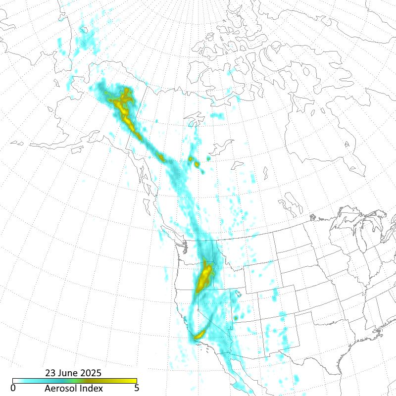
A series of pyroCb events in Alaska over the last few days have combined with high altitude windws to produce a smoke plume that stretches across Alaska, through western Canada / US, and into California / Nevada. This image shows N20 OMPS AI measurements. The length of the plume is over 4500 km.
June 24, 2025 at 6:59 AM
A series of pyroCb events in Alaska over the last few days have combined with high altitude windws to produce a smoke plume that stretches across Alaska, through western Canada / US, and into California / Nevada. This image shows N20 OMPS AI measurements. The length of the plume is over 4500 km.
Imagery using the N20 OMPS NM aerosol index shows that the smoke did go over the pole (watch the AI signal inside the circle). It's now in the easternmost part of Russia.
June 11, 2025 at 1:45 PM
Imagery using the N20 OMPS NM aerosol index shows that the smoke did go over the pole (watch the AI signal inside the circle). It's now in the easternmost part of Russia.
Here's the aerosol index image from the OMPS nadir mapper sensor onboard the NOAA 21 satellite. Note the definition of the AI is different from what TROPOMI (the instrument on Sentinel 5P) uses. I "pulled out" a bit so you can see the plume that spans across the Atlantic and over Europe.

June 2, 2025 at 6:56 AM
Here's the aerosol index image from the OMPS nadir mapper sensor onboard the NOAA 21 satellite. Note the definition of the AI is different from what TROPOMI (the instrument on Sentinel 5P) uses. I "pulled out" a bit so you can see the plume that spans across the Atlantic and over Europe.
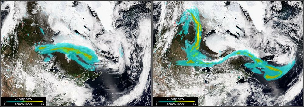
The Canadian fire situation intensified over the last 2 days, resulting in a number of pyroCb events. This image shows the N21 OMPS AI overlayed on N21 VIIRS RGB imagery for 28/29 May. Smoke stretches across a large portion of the country, well into the Atlantic, and is now moving into the US.
May 30, 2025 at 10:34 AM
The Canadian fire situation intensified over the last 2 days, resulting in a number of pyroCb events. This image shows the N21 OMPS AI overlayed on N21 VIIRS RGB imagery for 28/29 May. Smoke stretches across a large portion of the country, well into the Atlantic, and is now moving into the US.
And here's what earlier today looks like over Russia. I used data from N20 for OMPS and VIIRS this time. I also added N20 VIIRS hotspot detection; those are the red splotches on the image; you have to look carefully to spot some of them.

May 28, 2025 at 1:29 PM
And here's what earlier today looks like over Russia. I used data from N20 for OMPS and VIIRS this time. I also added N20 VIIRS hotspot detection; those are the red splotches on the image; you have to look carefully to spot some of them.
Large scale smoke plumes over Canada and Russia were produced from Pyrocumulonimbus (pyroCb) activity over both countries. Shown in this image are Aerosol Index (AI) measurements from the OMPS sensor onboard the NOAA 21 (N21) satellite overlayed on RGB imagery from N21's VIIRS sensor.

May 28, 2025 at 8:03 AM
Large scale smoke plumes over Canada and Russia were produced from Pyrocumulonimbus (pyroCb) activity over both countries. Shown in this image are Aerosol Index (AI) measurements from the OMPS sensor onboard the NOAA 21 (N21) satellite overlayed on RGB imagery from N21's VIIRS sensor.
A pyroCb event occurred in southwestern Manitoba, Canada on 13 May. The resulted smoke plume (as seen by the N21 OMPS aerosol index) traveled across the Atlantic and is now located over the Mediterranean just west of Italy. Looks like it may be a long summer for these kinds of events.
May 19, 2025 at 5:14 PM
A pyroCb event occurred in southwestern Manitoba, Canada on 13 May. The resulted smoke plume (as seen by the N21 OMPS aerosol index) traveled across the Atlantic and is now located over the Mediterranean just west of Italy. Looks like it may be a long summer for these kinds of events.
Are these images from S-NPP VIIRS? If so, I think it's just sun glint. This guess is bolstered by the fact it's, more or less, a continuation of glint seen further north, plus nothing is seen in either N20 or N21 VIIRS RGB imagery.

February 25, 2025 at 8:31 PM
Are these images from S-NPP VIIRS? If so, I think it's just sun glint. This guess is bolstered by the fact it's, more or less, a continuation of glint seen further north, plus nothing is seen in either N20 or N21 VIIRS RGB imagery.
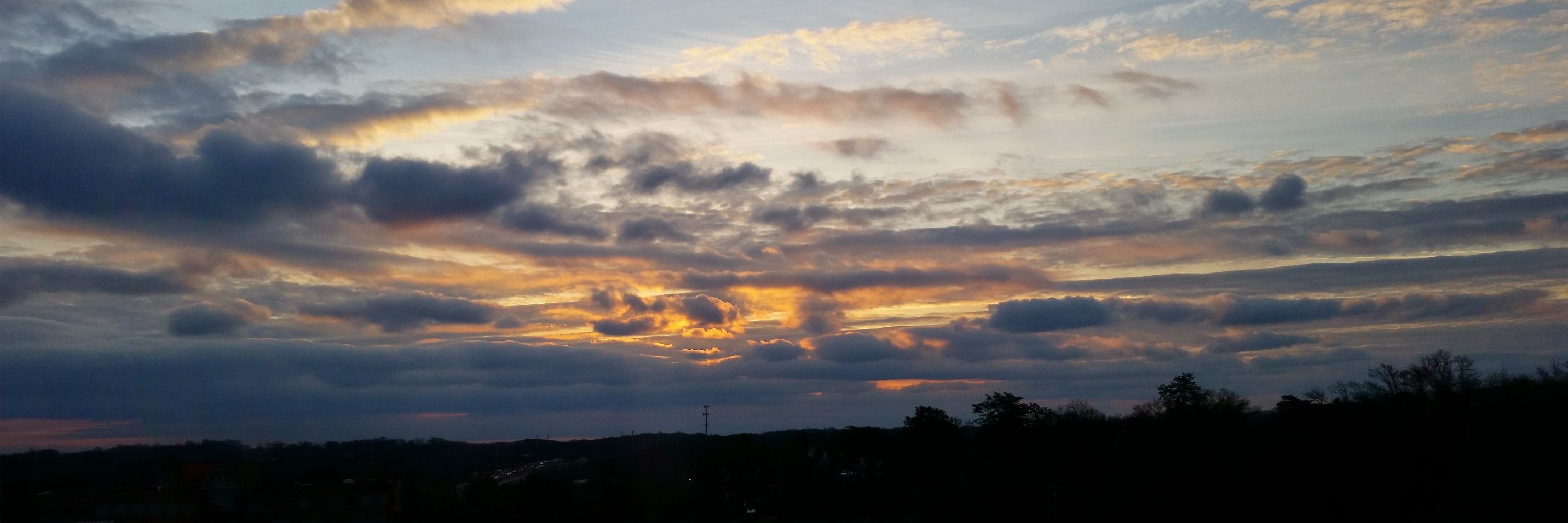
Beautiful sunrise this morning in the DC area, a day or so after the big (for us, anyway) snowstorm.

January 8, 2025 at 1:05 PM
Beautiful sunrise this morning in the DC area, a day or so after the big (for us, anyway) snowstorm.
First pyroCb event of the southern hemisphere summer occurred on 20 December from a fire burning in Grampians National Park in Australia. Here's the Aerosol Index from NOAA-20 OMPS showing the smoke plume generated by the event.

December 21, 2024 at 9:25 AM
First pyroCb event of the southern hemisphere summer occurred on 20 December from a fire burning in Grampians National Park in Australia. Here's the Aerosol Index from NOAA-20 OMPS showing the smoke plume generated by the event.
I joined Blue Sky quite awhile ago but haven't yet posted. So let's start things off with a quick animation of this year's ozone hole as seen by the S-NPP OMPS instrument. NASA/NOAA say that it's a relatively small hole this year, evidence of the Montreal Protocol at work.
November 24, 2024 at 7:44 PM
I joined Blue Sky quite awhile ago but haven't yet posted. So let's start things off with a quick animation of this year's ozone hole as seen by the S-NPP OMPS instrument. NASA/NOAA say that it's a relatively small hole this year, evidence of the Montreal Protocol at work.