


Extreme & Convective Events
@convectiveuk.bsky.social
Forecasting Thunderstorms & Convective events within the British Isles. Forecasted by a small group of amateur meteorologists.
Snow Outlook - 7th January:
Snow/sleet showers will track into parts of Ireland, Wales N Eng & into Midlands. Slight dusting / covering could be seen within these LOW warning zones.
Heavy snow showers will track into Scotland bringing 4-8cm.
Snow/sleet showers will track into parts of Ireland, Wales N Eng & into Midlands. Slight dusting / covering could be seen within these LOW warning zones.
Heavy snow showers will track into Scotland bringing 4-8cm.

January 7, 2025 at 1:01 PM
Snow Outlook - 7th January:
Snow/sleet showers will track into parts of Ireland, Wales N Eng & into Midlands. Slight dusting / covering could be seen within these LOW warning zones.
Heavy snow showers will track into Scotland bringing 4-8cm.
Snow/sleet showers will track into parts of Ireland, Wales N Eng & into Midlands. Slight dusting / covering could be seen within these LOW warning zones.
Heavy snow showers will track into Scotland bringing 4-8cm.
Snow Outlook - Mon/Tue 6/7th January:
Snow showers will track into England, Scotland & Ireland where widespread dusting/slight covering could be seen in heaviest bursts, with 4-8cm expected across N Scotland, Wales, N & far SE parts of Ireland.
Video coming shortly!
Snow showers will track into England, Scotland & Ireland where widespread dusting/slight covering could be seen in heaviest bursts, with 4-8cm expected across N Scotland, Wales, N & far SE parts of Ireland.
Video coming shortly!

January 6, 2025 at 2:57 PM
Snow Outlook - Mon/Tue 6/7th January:
Snow showers will track into England, Scotland & Ireland where widespread dusting/slight covering could be seen in heaviest bursts, with 4-8cm expected across N Scotland, Wales, N & far SE parts of Ireland.
Video coming shortly!
Snow showers will track into England, Scotland & Ireland where widespread dusting/slight covering could be seen in heaviest bursts, with 4-8cm expected across N Scotland, Wales, N & far SE parts of Ireland.
Video coming shortly!
Wind Outlook - Wednesday 25th Sept:
A few frontal systems move round the Irish Sea, and along the occluded front in the SE, the isobars being pushed tightest likely towards the southern area of Wales. Where they could be channelled into forcing a few gusts in excess of 50mph. 🌬️
A few frontal systems move round the Irish Sea, and along the occluded front in the SE, the isobars being pushed tightest likely towards the southern area of Wales. Where they could be channelled into forcing a few gusts in excess of 50mph. 🌬️

September 24, 2024 at 9:39 PM
Wind Outlook - Wednesday 25th Sept:
A few frontal systems move round the Irish Sea, and along the occluded front in the SE, the isobars being pushed tightest likely towards the southern area of Wales. Where they could be channelled into forcing a few gusts in excess of 50mph. 🌬️
A few frontal systems move round the Irish Sea, and along the occluded front in the SE, the isobars being pushed tightest likely towards the southern area of Wales. Where they could be channelled into forcing a few gusts in excess of 50mph. 🌬️
Wednesday 25th September:
A front will track across the country with the chance of occasional embedded lightning affecting England, quickly followed by a potent trough.
This trough will track into SW Eng heading E bringing active thunderstorms.
Update - Tomorrow Morning
A front will track across the country with the chance of occasional embedded lightning affecting England, quickly followed by a potent trough.
This trough will track into SW Eng heading E bringing active thunderstorms.
Update - Tomorrow Morning

September 24, 2024 at 9:39 PM
Wednesday 25th September:
A front will track across the country with the chance of occasional embedded lightning affecting England, quickly followed by a potent trough.
This trough will track into SW Eng heading E bringing active thunderstorms.
Update - Tomorrow Morning
A front will track across the country with the chance of occasional embedded lightning affecting England, quickly followed by a potent trough.
This trough will track into SW Eng heading E bringing active thunderstorms.
Update - Tomorrow Morning
Hey Everyone, 👋
Whilst convective risks has died down, we have been busy making a few new graphics:
- Wind Outlook
- Snow Outlook
A different style to how the risks are shown have been presented on these outlooks, examples can be found bellow.
Let us know what you think! 😆
Whilst convective risks has died down, we have been busy making a few new graphics:
- Wind Outlook
- Snow Outlook
A different style to how the risks are shown have been presented on these outlooks, examples can be found bellow.
Let us know what you think! 😆


September 17, 2024 at 10:51 AM
Hey Everyone, 👋
Whilst convective risks has died down, we have been busy making a few new graphics:
- Wind Outlook
- Snow Outlook
A different style to how the risks are shown have been presented on these outlooks, examples can be found bellow.
Let us know what you think! 😆
Whilst convective risks has died down, we have been busy making a few new graphics:
- Wind Outlook
- Snow Outlook
A different style to how the risks are shown have been presented on these outlooks, examples can be found bellow.
Let us know what you think! 😆
2/2
The high pressure will advect north with lower pressure across Europe. Looking at a few models, there seems to be a drastic increase in convective risk during Thursday & Friday.
Exact details are uncertain however the risk *MAY* increase later in the week.
The high pressure will advect north with lower pressure across Europe. Looking at a few models, there seems to be a drastic increase in convective risk during Thursday & Friday.
Exact details are uncertain however the risk *MAY* increase later in the week.


September 15, 2024 at 10:16 AM
2/2
The high pressure will advect north with lower pressure across Europe. Looking at a few models, there seems to be a drastic increase in convective risk during Thursday & Friday.
Exact details are uncertain however the risk *MAY* increase later in the week.
The high pressure will advect north with lower pressure across Europe. Looking at a few models, there seems to be a drastic increase in convective risk during Thursday & Friday.
Exact details are uncertain however the risk *MAY* increase later in the week.
Convective risk seems to reduce over the coming days as higher pressures builds in bringing clear, sunny, dry & warm weather. Temperatures are expected to rise into the low/mid 20s.
1/2
1/2


September 15, 2024 at 10:16 AM
Convective risk seems to reduce over the coming days as higher pressures builds in bringing clear, sunny, dry & warm weather. Temperatures are expected to rise into the low/mid 20s.
1/2
1/2
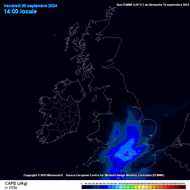
Sunday 15th September:
An occluded front will track into W & NW Scotland bringing the risk of thunderstorms as MU CAPE rises throughout the day up to 600J/KG.
Lightning will remain sporadic. ⚡️
An occluded front will track into W & NW Scotland bringing the risk of thunderstorms as MU CAPE rises throughout the day up to 600J/KG.
Lightning will remain sporadic. ⚡️

September 15, 2024 at 10:04 AM
Sunday 15th September:
An occluded front will track into W & NW Scotland bringing the risk of thunderstorms as MU CAPE rises throughout the day up to 600J/KG.
Lightning will remain sporadic. ⚡️
An occluded front will track into W & NW Scotland bringing the risk of thunderstorms as MU CAPE rises throughout the day up to 600J/KG.
Lightning will remain sporadic. ⚡️
Friday 6th September:
Multiple rounds of thunderstorms expected across S England especially active & severe ones across Sussex stretching towards Cardiff.
These storms could become severe bringing frequent lightning & flooding to many parts of S/SE England. ⚡️
Multiple rounds of thunderstorms expected across S England especially active & severe ones across Sussex stretching towards Cardiff.
These storms could become severe bringing frequent lightning & flooding to many parts of S/SE England. ⚡️

September 5, 2024 at 9:32 PM
Friday 6th September:
Multiple rounds of thunderstorms expected across S England especially active & severe ones across Sussex stretching towards Cardiff.
These storms could become severe bringing frequent lightning & flooding to many parts of S/SE England. ⚡️
Multiple rounds of thunderstorms expected across S England especially active & severe ones across Sussex stretching towards Cardiff.
These storms could become severe bringing frequent lightning & flooding to many parts of S/SE England. ⚡️
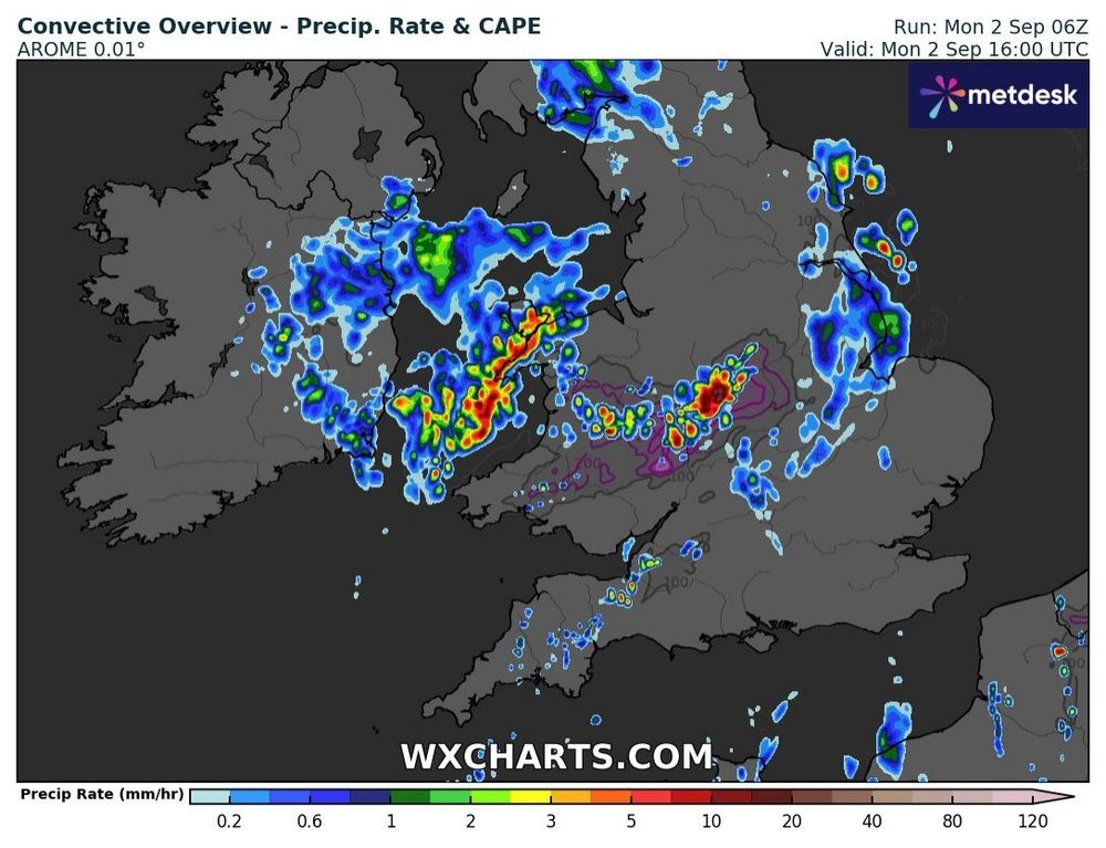
A few showers maybe the odd thunderstorm is expected to develop in the coming hours across Wales stretching into the Midlands.
Lightning will remain low if not nothing due to the low amount of CAPE. However a few strikes can't be ruled out ⚡️
Lightning will remain low if not nothing due to the low amount of CAPE. However a few strikes can't be ruled out ⚡️
September 2, 2024 at 12:35 PM
A few showers maybe the odd thunderstorm is expected to develop in the coming hours across Wales stretching into the Midlands.
Lightning will remain low if not nothing due to the low amount of CAPE. However a few strikes can't be ruled out ⚡️
Lightning will remain low if not nothing due to the low amount of CAPE. However a few strikes can't be ruled out ⚡️
Tuesday 27th August:
Intense showers are expected to form overnight Monday across Ireland & Scotland where some instability exists.
Sporadic lightning is expected especially across SW/W parts of Ireland where higher instability exhibits.
Risk remains very low though. ⚡️
Intense showers are expected to form overnight Monday across Ireland & Scotland where some instability exists.
Sporadic lightning is expected especially across SW/W parts of Ireland where higher instability exhibits.
Risk remains very low though. ⚡️

August 26, 2024 at 7:26 PM
Tuesday 27th August:
Intense showers are expected to form overnight Monday across Ireland & Scotland where some instability exists.
Sporadic lightning is expected especially across SW/W parts of Ireland where higher instability exhibits.
Risk remains very low though. ⚡️
Intense showers are expected to form overnight Monday across Ireland & Scotland where some instability exists.
Sporadic lightning is expected especially across SW/W parts of Ireland where higher instability exhibits.
Risk remains very low though. ⚡️
Friday 23rd Morning:
Storm Lillian is expected to affect northern England during the early hours alongside thunderstorms & sporadic lightning expected as it moves through.
Lightning is expected to remain limited, however it could pep up for a time.
Storm Lillian is expected to affect northern England during the early hours alongside thunderstorms & sporadic lightning expected as it moves through.
Lightning is expected to remain limited, however it could pep up for a time.

August 22, 2024 at 8:43 PM
Friday 23rd Morning:
Storm Lillian is expected to affect northern England during the early hours alongside thunderstorms & sporadic lightning expected as it moves through.
Lightning is expected to remain limited, however it could pep up for a time.
Storm Lillian is expected to affect northern England during the early hours alongside thunderstorms & sporadic lightning expected as it moves through.
Lightning is expected to remain limited, however it could pep up for a time.
Thundery showers across Scotland today as SB CAPE rises to 600J/KG in places that could allow sporadic lightning to take place. ⚡️
There was no time to publish an outlook today, however a low risk certainly an AOI would've been issued for Scotland.
There was no time to publish an outlook today, however a low risk certainly an AOI would've been issued for Scotland.


August 20, 2024 at 8:19 AM
Thundery showers across Scotland today as SB CAPE rises to 600J/KG in places that could allow sporadic lightning to take place. ⚡️
There was no time to publish an outlook today, however a low risk certainly an AOI would've been issued for Scotland.
There was no time to publish an outlook today, however a low risk certainly an AOI would've been issued for Scotland.
Hey Blue sky, new on this platform 💙
A threat of possible thunderstorms across Wales mainly staying within the Bristol Channel, Irish / Celtic Sea early hours tomorrow.
Looking closely at this threat this evening, an outlook may be required ⚡️
A threat of possible thunderstorms across Wales mainly staying within the Bristol Channel, Irish / Celtic Sea early hours tomorrow.
Looking closely at this threat this evening, an outlook may be required ⚡️


August 19, 2024 at 3:26 PM
Hey Blue sky, new on this platform 💙
A threat of possible thunderstorms across Wales mainly staying within the Bristol Channel, Irish / Celtic Sea early hours tomorrow.
Looking closely at this threat this evening, an outlook may be required ⚡️
A threat of possible thunderstorms across Wales mainly staying within the Bristol Channel, Irish / Celtic Sea early hours tomorrow.
Looking closely at this threat this evening, an outlook may be required ⚡️