


Chris Kuball
@chriskuball.bsky.social
Meteorologist at We Are Iowa - Local 5 in West Des Moines, Iowa
Iowa State University Graduate and Fanatic
641>515>507>515
Iowa State University Graduate and Fanatic
641>515>507>515
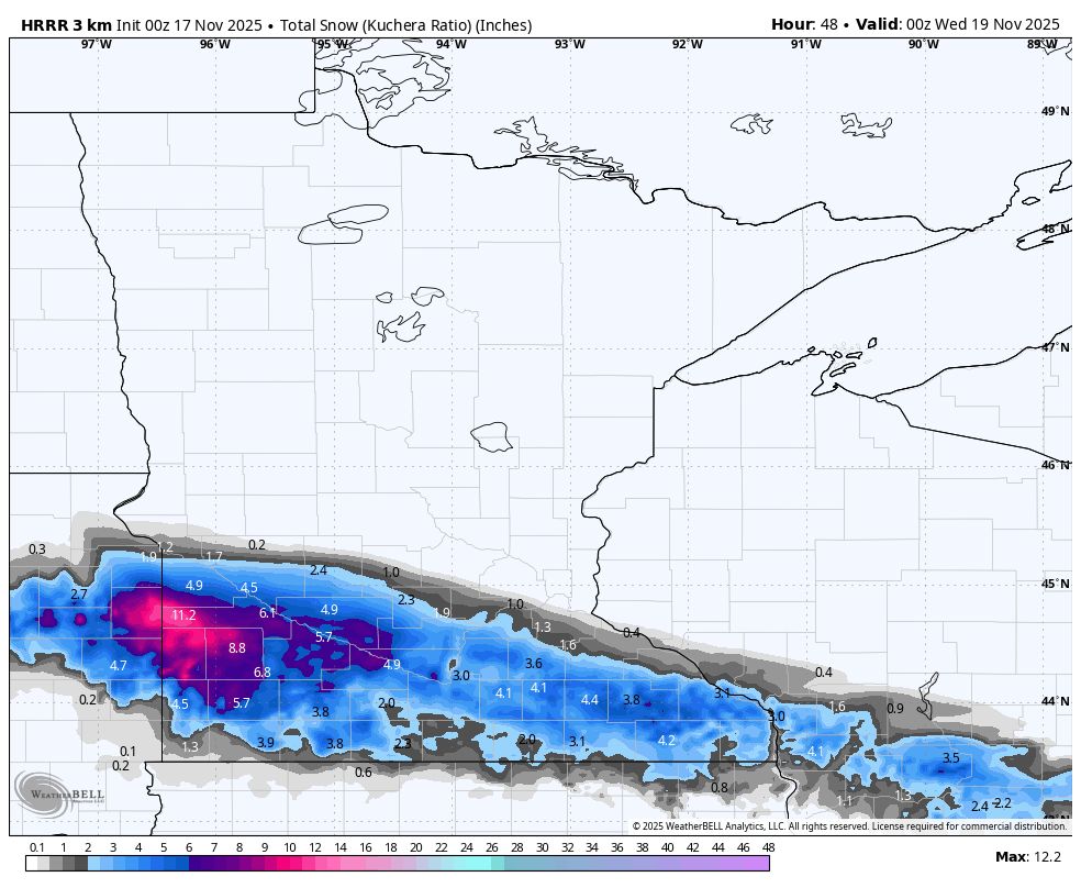
Heads up southern Minnesota. CAMs are coming in hot with snow prospects Monday night into Tuesday morning. Not sure I'm buying big time totals like some are showing, but certainly some accumulations worthy of watching. #MNWX


November 17, 2025 at 3:04 AM
Heads up southern Minnesota. CAMs are coming in hot with snow prospects Monday night into Tuesday morning. Not sure I'm buying big time totals like some are showing, but certainly some accumulations worthy of watching. #MNWX
Looks like a pretty stout push of Arctic Air possible out towards the holiday weekend. This would follow a strong cold front/storm system which could also bring some wintry precip somewhere in the middle of the country.
Not much you can take from it just yet, but keep an eye on Thu-Sun next week.
Not much you can take from it just yet, but keep an eye on Thu-Sun next week.

November 16, 2025 at 10:48 PM
Looks like a pretty stout push of Arctic Air possible out towards the holiday weekend. This would follow a strong cold front/storm system which could also bring some wintry precip somewhere in the middle of the country.
Not much you can take from it just yet, but keep an eye on Thu-Sun next week.
Not much you can take from it just yet, but keep an eye on Thu-Sun next week.
GFS is still sticking to its guns with a decent snow band trying to develop somewhere across Iowa up into Minnesota on Monday night. I'm just not buying the solution being given. The thermal profile of the atmosphere either side of the border under this band is just too warm. #IAWX #MNWX


November 15, 2025 at 12:29 AM
Snow to Record highs in a week! What a difference across the state from last Saturday to today!

November 15, 2025 at 12:12 AM
Snow to Record highs in a week! What a difference across the state from last Saturday to today!
Because when I think Southern California, I think of an onslaught of rain, clouds and 60°... said no one ever.
Back to back weeks of soaking rain as the Iowa #Hawkeyes face the USC #Trojans in the Coliseum. Temps in the low 60s and sloppy playing conditions are expected.
Back to back weeks of soaking rain as the Iowa #Hawkeyes face the USC #Trojans in the Coliseum. Temps in the low 60s and sloppy playing conditions are expected.
November 14, 2025 at 11:09 PM
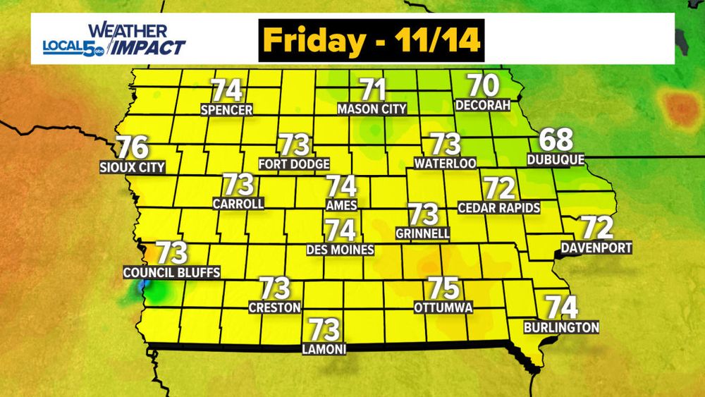
70s on the way Friday. Here's your not to get out of work or school. I promise this is official and will be an excused absence.

November 14, 2025 at 4:14 AM
70s on the way Friday. Here's your not to get out of work or school. I promise this is official and will be an excused absence.
Two models. Two very different outcomes. This is the biggest focal point for my forecast today.
Euro showing a rainy scenario for Tuesday night. GFS has been stubborn on the snowy scenario.
#IAWX
Euro showing a rainy scenario for Tuesday night. GFS has been stubborn on the snowy scenario.
#IAWX


November 13, 2025 at 8:10 PM
Two models. Two very different outcomes. This is the biggest focal point for my forecast today.
Euro showing a rainy scenario for Tuesday night. GFS has been stubborn on the snowy scenario.
#IAWX
Euro showing a rainy scenario for Tuesday night. GFS has been stubborn on the snowy scenario.
#IAWX
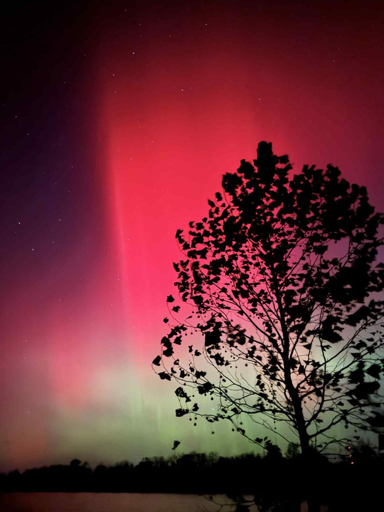
Just watch. You won't be disappointed.
Northern Lights Tuesday Night as seen from Knoxville, Iowa from roughly 7-10PM.
#NorthernLights #Aurora #IAWX
Northern Lights Tuesday Night as seen from Knoxville, Iowa from roughly 7-10PM.
#NorthernLights #Aurora #IAWX
November 12, 2025 at 4:57 AM
Just watch. You won't be disappointed.
Northern Lights Tuesday Night as seen from Knoxville, Iowa from roughly 7-10PM.
#NorthernLights #Aurora #IAWX
Northern Lights Tuesday Night as seen from Knoxville, Iowa from roughly 7-10PM.
#NorthernLights #Aurora #IAWX
I can't pick my favorite Northern Lights shot. It's been such a great show and it's still not done. Check this one out from Green Valley Lake
📷Tessa Stoffer
📍Creston, IA
#NorthernLights
📷Tessa Stoffer
📍Creston, IA
#NorthernLights

November 12, 2025 at 4:02 AM
I can't pick my favorite Northern Lights shot. It's been such a great show and it's still not done. Check this one out from Green Valley Lake
📷Tessa Stoffer
📍Creston, IA
#NorthernLights
📷Tessa Stoffer
📍Creston, IA
#NorthernLights
Wow! Looking up and slightly to the *south* into the Aurora. This is the pinnacle of Northern Lights viewing... when you can get the best to happen right above you. Amazing.
📷Tim Cody
📍Stewartville, MN
#NorthernLights
📷Tim Cody
📍Stewartville, MN
#NorthernLights

November 12, 2025 at 3:43 AM
Wow! Looking up and slightly to the *south* into the Aurora. This is the pinnacle of Northern Lights viewing... when you can get the best to happen right above you. Amazing.
📷Tim Cody
📍Stewartville, MN
#NorthernLights
📷Tim Cody
📍Stewartville, MN
#NorthernLights
Tonight's Northern Lights as seen from Booneville, IA. Such an amazing show!
📷Adrik Feitelson
📷Adrik Feitelson

November 12, 2025 at 3:41 AM
Tonight's Northern Lights as seen from Booneville, IA. Such an amazing show!
📷Adrik Feitelson
📷Adrik Feitelson
Stunning. Simply stunning.
This Northern Lights display has been unmatched by any I've ever seen... and I've seen several.
Taken near Big Creek State Park in central Iowa tonight.
#NorthernLights #Aurora
This Northern Lights display has been unmatched by any I've ever seen... and I've seen several.
Taken near Big Creek State Park in central Iowa tonight.
#NorthernLights #Aurora
November 12, 2025 at 2:59 AM
Stunning. Simply stunning.
This Northern Lights display has been unmatched by any I've ever seen... and I've seen several.
Taken near Big Creek State Park in central Iowa tonight.
#NorthernLights #Aurora
This Northern Lights display has been unmatched by any I've ever seen... and I've seen several.
Taken near Big Creek State Park in central Iowa tonight.
#NorthernLights #Aurora
Northern Lights are *OUT* A look as of 6:30 PM from our Knoxville, Iowa camera. Let's see those shots in the comments!

November 12, 2025 at 12:34 AM
Northern Lights are *OUT* A look as of 6:30 PM from our Knoxville, Iowa camera. Let's see those shots in the comments!
Looking like the night sky will largely cooperate across the Upper Midwest for our potential Northern Lights show. *IF* they materialize I'm looking at only a few high cirrus clouds drifting through after midnight across northern Iowa into southern Minnesota. I'll be watching as we go into evening


November 11, 2025 at 10:56 PM
Looking like the night sky will largely cooperate across the Upper Midwest for our potential Northern Lights show. *IF* they materialize I'm looking at only a few high cirrus clouds drifting through after midnight across northern Iowa into southern Minnesota. I'll be watching as we go into evening
Still some snow on the ground in NW Iowa into South Dakota... but not for long. Melting away quickly on this Tuesday afternoon.
November 11, 2025 at 7:27 PM
Still some snow on the ground in NW Iowa into South Dakota... but not for long. Melting away quickly on this Tuesday afternoon.
The seasons clash over Glidden in NW Iowa Sunday. Snow from Saturday contrasts well with the fall colors still clinging to the trees. Great shot from above.
📷Kent Brant
📍Glidden, IA
📷Kent Brant
📍Glidden, IA

November 11, 2025 at 4:05 AM
The seasons clash over Glidden in NW Iowa Sunday. Snow from Saturday contrasts well with the fall colors still clinging to the trees. Great shot from above.
📷Kent Brant
📍Glidden, IA
📷Kent Brant
📍Glidden, IA


Here's your #Fastcast for this Monday evening. Don't like the cold? Don't worry. We'll be back to milder air before you know it! #KeepScrolling
November 10, 2025 at 11:22 PM
Here's your #Fastcast for this Monday evening. Don't like the cold? Don't worry. We'll be back to milder air before you know it! #KeepScrolling
A recap of snow totals from Saturday across NW Iowa, South Dakota, Nebraska and Minnesota. High marks peaked around 5".

November 10, 2025 at 7:48 PM
A recap of snow totals from Saturday across NW Iowa, South Dakota, Nebraska and Minnesota. High marks peaked around 5".
A look on visible satellite shows where snow accumulated (and stuck long term) on Saturday. Pretty neat view from above.
Others further south and east of this line saw snow but it didn't stay very long on the ground.
Others further south and east of this line saw snow but it didn't stay very long on the ground.

November 9, 2025 at 4:17 PM
A look on visible satellite shows where snow accumulated (and stuck long term) on Saturday. Pretty neat view from above.
Others further south and east of this line saw snow but it didn't stay very long on the ground.
Others further south and east of this line saw snow but it didn't stay very long on the ground.
The daytime scenario is really helping out the road situation across the state. Seeing snow about the US 30 corridor and points north across IA and extending into southern MN. These sites across north Iowa are generally showing roads wet. But watch out for bridges that will slush up more easily.


November 8, 2025 at 6:27 PM
The daytime scenario is really helping out the road situation across the state. Seeing snow about the US 30 corridor and points north across IA and extending into southern MN. These sites across north Iowa are generally showing roads wet. But watch out for bridges that will slush up more easily.
Not a ton sticking at each of these camera sites at various points in Iowa... but they sure do look like a snow globe!


November 8, 2025 at 6:25 PM
Not a ton sticking at each of these camera sites at various points in Iowa... but they sure do look like a snow globe!
Rain is mixing in with snow in parts of Iowa north of I80. Look for this transition to generally stay into the northern half of Iowa. Accumulations of a few inches possible as we extend into the afternoon. #IAWX

November 8, 2025 at 4:08 PM
Rain is mixing in with snow in parts of Iowa north of I80. Look for this transition to generally stay into the northern half of Iowa. Accumulations of a few inches possible as we extend into the afternoon. #IAWX
Snow is coming down really good in parts of N/NW Iowa. This is near Fort Dodge on US 20. Looks like travel is moving pretty good with mainly wet roads at this spot. But watch those bridges as you can see here! They're going to slush up first! Take it easy today. #IAWX #Snow
November 8, 2025 at 3:58 PM
Snow is sticking in NW Iowa. A look outside near Sheldon on Saturday morning.
I'm expecting some of the highest accumulations to occur in this part of the state. This is where 2-4" of snow will be possible. Less will fall further south and east.
I'm expecting some of the highest accumulations to occur in this part of the state. This is where 2-4" of snow will be possible. Less will fall further south and east.

November 8, 2025 at 2:12 PM
Snow is sticking in NW Iowa. A look outside near Sheldon on Saturday morning.
I'm expecting some of the highest accumulations to occur in this part of the state. This is where 2-4" of snow will be possible. Less will fall further south and east.
I'm expecting some of the highest accumulations to occur in this part of the state. This is where 2-4" of snow will be possible. Less will fall further south and east.