


Chaney Swiney
@chaneyswiney.com
cartographer, geographer, & field-checker for Benchmark Maps & Raven Maps
photographer & naturalist on my own
www.chaneyswiney.com
photographer & naturalist on my own
www.chaneyswiney.com
#30DayMapChallenge Day 13: 10 Minute Map
I will always default to shaded relief and mountains, so this one was an easy idea: make a beautiful, unlabeled map using Eduard. I wasted almost a quarter of my 10 minutes trying to pick some mountains. Glacier Peak worked out in the end.
I will always default to shaded relief and mountains, so this one was an easy idea: make a beautiful, unlabeled map using Eduard. I wasted almost a quarter of my 10 minutes trying to pick some mountains. Glacier Peak worked out in the end.

November 13, 2025 at 6:43 PM
#30DayMapChallenge Day 13: 10 Minute Map
I will always default to shaded relief and mountains, so this one was an easy idea: make a beautiful, unlabeled map using Eduard. I wasted almost a quarter of my 10 minutes trying to pick some mountains. Glacier Peak worked out in the end.
I will always default to shaded relief and mountains, so this one was an easy idea: make a beautiful, unlabeled map using Eduard. I wasted almost a quarter of my 10 minutes trying to pick some mountains. Glacier Peak worked out in the end.
On this day in 1971, Arches became a national park, so of course that means it's time to celebrate with a map! This is the landscape version of the park from Raven's new Parklands series. Like the Canyonlands map I shared before, this color is all derived from some heavily processed aerial imagery.


November 12, 2025 at 7:59 PM
On this day in 1971, Arches became a national park, so of course that means it's time to celebrate with a map! This is the landscape version of the park from Raven's new Parklands series. Like the Canyonlands map I shared before, this color is all derived from some heavily processed aerial imagery.
#30DayMapChallenge Day 12: Map from 2125
What if we just intentionally misread it as "Map from 21º, 25º" and then make all four variants?
What if we just intentionally misread it as "Map from 21º, 25º" and then make all four variants?

November 12, 2025 at 5:03 PM
#30DayMapChallenge Day 12: Map from 2125
What if we just intentionally misread it as "Map from 21º, 25º" and then make all four variants?
What if we just intentionally misread it as "Map from 21º, 25º" and then make all four variants?
Aurora in Asheville! Missed it 18 months ago, but not this time.

November 12, 2025 at 3:41 AM
Aurora in Asheville! Missed it 18 months ago, but not this time.
#30DayMapChallenge Day 11 - Minimal Map
Made this series a while ago, simple views of lakes around Central Oregon. Tough to pick a favorite, but I sure do love Sparks Lake. I like the understated bathymetric shading and the faint contour lines on land. And the lake stats. Love some lake stats.
Made this series a while ago, simple views of lakes around Central Oregon. Tough to pick a favorite, but I sure do love Sparks Lake. I like the understated bathymetric shading and the faint contour lines on land. And the lake stats. Love some lake stats.

November 11, 2025 at 10:31 PM
#30DayMapChallenge Day 11 - Minimal Map
Made this series a while ago, simple views of lakes around Central Oregon. Tough to pick a favorite, but I sure do love Sparks Lake. I like the understated bathymetric shading and the faint contour lines on land. And the lake stats. Love some lake stats.
Made this series a while ago, simple views of lakes around Central Oregon. Tough to pick a favorite, but I sure do love Sparks Lake. I like the understated bathymetric shading and the faint contour lines on land. And the lake stats. Love some lake stats.
#30DayMapChallenge Day 10 - Air
One of my favorite pages to build for Benchmark's Alaska Atlas was this page all about transportation in the state. A big focus of the map and guide was regular air service to the more remote communities, showing all the airports and estimates of flight durations.
One of my favorite pages to build for Benchmark's Alaska Atlas was this page all about transportation in the state. A big focus of the map and guide was regular air service to the more remote communities, showing all the airports and estimates of flight durations.


November 11, 2025 at 1:37 PM
#30DayMapChallenge Day 10 - Air
One of my favorite pages to build for Benchmark's Alaska Atlas was this page all about transportation in the state. A big focus of the map and guide was regular air service to the more remote communities, showing all the airports and estimates of flight durations.
One of my favorite pages to build for Benchmark's Alaska Atlas was this page all about transportation in the state. A big focus of the map and guide was regular air service to the more remote communities, showing all the airports and estimates of flight durations.
#30DayMapChallenge Day 9 - Analog
I've never done much in the way of hand-drawn maps, but there was a time when I was trying to insert them into my notebooks where I was recording different adventures. Here's two from a winter camping trip at Lassen Volcanic National Park.
I've never done much in the way of hand-drawn maps, but there was a time when I was trying to insert them into my notebooks where I was recording different adventures. Here's two from a winter camping trip at Lassen Volcanic National Park.


November 11, 2025 at 1:29 PM
#30DayMapChallenge Day 9 - Analog
I've never done much in the way of hand-drawn maps, but there was a time when I was trying to insert them into my notebooks where I was recording different adventures. Here's two from a winter camping trip at Lassen Volcanic National Park.
I've never done much in the way of hand-drawn maps, but there was a time when I was trying to insert them into my notebooks where I was recording different adventures. Here's two from a winter camping trip at Lassen Volcanic National Park.
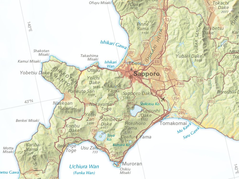
Playing catch up on the #30DayMapChallenge with some pre-existing maps to fit the themes...
8 - Urban
I work on a lot of smaller scale maps with less urban focus. Here's two looks at some newer Raven maps: Minnesota and Japan. We went with red for built-up areas in Japan but chose gray for MN.
8 - Urban
I work on a lot of smaller scale maps with less urban focus. Here's two looks at some newer Raven maps: Minnesota and Japan. We went with red for built-up areas in Japan but chose gray for MN.


November 11, 2025 at 1:24 PM
Playing catch up on the #30DayMapChallenge with some pre-existing maps to fit the themes...
8 - Urban
I work on a lot of smaller scale maps with less urban focus. Here's two looks at some newer Raven maps: Minnesota and Japan. We went with red for built-up areas in Japan but chose gray for MN.
8 - Urban
I work on a lot of smaller scale maps with less urban focus. Here's two looks at some newer Raven maps: Minnesota and Japan. We went with red for built-up areas in Japan but chose gray for MN.
#30DayMapChallenge Day 7: Accessibility
I like the idea of remote spots: the points furthest from a road in a given area. A few years ago, I figured out what I think that point is in TN ahead of a trip on the AT through the Smokies. Trip got cancelled, but the spot's still out there...
I like the idea of remote spots: the points furthest from a road in a given area. A few years ago, I figured out what I think that point is in TN ahead of a trip on the AT through the Smokies. Trip got cancelled, but the spot's still out there...

November 7, 2025 at 7:06 PM
#30DayMapChallenge Day 7: Accessibility
I like the idea of remote spots: the points furthest from a road in a given area. A few years ago, I figured out what I think that point is in TN ahead of a trip on the AT through the Smokies. Trip got cancelled, but the spot's still out there...
I like the idea of remote spots: the points furthest from a road in a given area. A few years ago, I figured out what I think that point is in TN ahead of a trip on the AT through the Smokies. Trip got cancelled, but the spot's still out there...
#30DayMapChallenge Day 6: Dimensions
Why not make a new Peakscape and lean into the dimension of depth? This is the first that isn't built only using a DEM. There's elevation data in there for the middleground and the La Sal Mtns, but Delicate Arch is pulled from one of my photos. What a landscape!
Why not make a new Peakscape and lean into the dimension of depth? This is the first that isn't built only using a DEM. There's elevation data in there for the middleground and the La Sal Mtns, but Delicate Arch is pulled from one of my photos. What a landscape!

November 6, 2025 at 11:43 PM
#30DayMapChallenge Day 6: Dimensions
Why not make a new Peakscape and lean into the dimension of depth? This is the first that isn't built only using a DEM. There's elevation data in there for the middleground and the La Sal Mtns, but Delicate Arch is pulled from one of my photos. What a landscape!
Why not make a new Peakscape and lean into the dimension of depth? This is the first that isn't built only using a DEM. There's elevation data in there for the middleground and the La Sal Mtns, but Delicate Arch is pulled from one of my photos. What a landscape!
#30DayMapChallenge Day 5: Earth
Repurposing some maps *and* doing some shameless self-promotion here. These are crops from the shaded relief for the new Parklands prints from Raven. Cover the bottom left corner if you want to try guessing the park just from the terrain!
See the full lineup here.
Repurposing some maps *and* doing some shameless self-promotion here. These are crops from the shaded relief for the new Parklands prints from Raven. Cover the bottom left corner if you want to try guessing the park just from the terrain!
See the full lineup here.


November 5, 2025 at 2:11 PM
#30DayMapChallenge Day 5: Earth
Repurposing some maps *and* doing some shameless self-promotion here. These are crops from the shaded relief for the new Parklands prints from Raven. Cover the bottom left corner if you want to try guessing the park just from the terrain!
See the full lineup here.
Repurposing some maps *and* doing some shameless self-promotion here. These are crops from the shaded relief for the new Parklands prints from Raven. Cover the bottom left corner if you want to try guessing the park just from the terrain!
See the full lineup here.
I just misread this as "Cold Gross Peak" and now I really wish that was its name.

November 4, 2025 at 8:32 PM
I just misread this as "Cold Gross Peak" and now I really wish that was its name.
#30DayMapChallenge Day 4: My Data
The latest update to my county map, my long term project tracking every county I've ever been in. Only two new ones of late, down on the NC coast around Wilmington. Closing in on 40% overall, and if I could get to Asotin County, WA I'd have three states filled in.
The latest update to my county map, my long term project tracking every county I've ever been in. Only two new ones of late, down on the NC coast around Wilmington. Closing in on 40% overall, and if I could get to Asotin County, WA I'd have three states filled in.

November 4, 2025 at 2:12 PM
#30DayMapChallenge Day 4: My Data
The latest update to my county map, my long term project tracking every county I've ever been in. Only two new ones of late, down on the NC coast around Wilmington. Closing in on 40% overall, and if I could get to Asotin County, WA I'd have three states filled in.
The latest update to my county map, my long term project tracking every county I've ever been in. Only two new ones of late, down on the NC coast around Wilmington. Closing in on 40% overall, and if I could get to Asotin County, WA I'd have three states filled in.
#30DayMapChallenge Day 3: Polygons
I am a sucker for good place names, and I will use them to bend a category to my will. Here are four selected summits around the US with polygonal names.
I am a sucker for good place names, and I will use them to bend a category to my will. Here are four selected summits around the US with polygonal names.

November 3, 2025 at 8:48 PM
#30DayMapChallenge Day 3: Polygons
I am a sucker for good place names, and I will use them to bend a category to my will. Here are four selected summits around the US with polygonal names.
I am a sucker for good place names, and I will use them to bend a category to my will. Here are four selected summits around the US with polygonal names.
#30DayMapChallenge Day 2: Lines
GPS tracks from 6 years of annual backpacking trips. Well… really 5 years. That 2024 line from the Smokies was just a big day trip, all we could squeeze in before Hurricane Helene. We thought we were picking the driest time of year, but it ended up being the wettest!
GPS tracks from 6 years of annual backpacking trips. Well… really 5 years. That 2024 line from the Smokies was just a big day trip, all we could squeeze in before Hurricane Helene. We thought we were picking the driest time of year, but it ended up being the wettest!

November 2, 2025 at 2:34 PM
#30DayMapChallenge Day 2: Lines
GPS tracks from 6 years of annual backpacking trips. Well… really 5 years. That 2024 line from the Smokies was just a big day trip, all we could squeeze in before Hurricane Helene. We thought we were picking the driest time of year, but it ended up being the wettest!
GPS tracks from 6 years of annual backpacking trips. Well… really 5 years. That 2024 line from the Smokies was just a big day trip, all we could squeeze in before Hurricane Helene. We thought we were picking the driest time of year, but it ended up being the wettest!
It’s November, so it’s time for the #30DayMapChallenge!
1: Points
Took a low res DEM, turned it into points, colored them with a Raven-style hypso ramp, and made Crater Lake blue. Kinda looks like a Lite Brite.
1: Points
Took a low res DEM, turned it into points, colored them with a Raven-style hypso ramp, and made Crater Lake blue. Kinda looks like a Lite Brite.

November 1, 2025 at 5:42 PM
It’s November, so it’s time for the #30DayMapChallenge!
1: Points
Took a low res DEM, turned it into points, colored them with a Raven-style hypso ramp, and made Crater Lake blue. Kinda looks like a Lite Brite.
1: Points
Took a low res DEM, turned it into points, colored them with a Raven-style hypso ramp, and made Crater Lake blue. Kinda looks like a Lite Brite.
Everything balances out. If there's a Big Rock Candy Mountain, then there's gotta be a...

October 29, 2025 at 7:37 PM
Everything balances out. If there's a Big Rock Candy Mountain, then there's gotta be a...
Rain and wind are here to steal the colors from the mountains, but I've got receipts of what was there before.

October 28, 2025 at 2:55 PM
Rain and wind are here to steal the colors from the mountains, but I've got receipts of what was there before.
Look at those colors. Autumn is moving downslope in the Blue Ridge Mountains, and it's going quick.

October 22, 2025 at 11:41 PM
Look at those colors. Autumn is moving downslope in the Blue Ridge Mountains, and it's going quick.
Another new Raven map was released yesterday alongside all those pretty park maps: the Caribbean Sea. Classic elevation tints and some wonderful shaded relief. That bathymetry is just so pretty...
#caribbean #map #bathymetry #shadedrelief
www.ravenmaps.com/caribbean-se...
#caribbean #map #bathymetry #shadedrelief
www.ravenmaps.com/caribbean-se...

October 22, 2025 at 4:30 PM
Another new Raven map was released yesterday alongside all those pretty park maps: the Caribbean Sea. Classic elevation tints and some wonderful shaded relief. That bathymetry is just so pretty...
#caribbean #map #bathymetry #shadedrelief
www.ravenmaps.com/caribbean-se...
#caribbean #map #bathymetry #shadedrelief
www.ravenmaps.com/caribbean-se...
There's a brand new series of prints available from Raven Maps & Images: Parklands. These were a blast to work on! We've got sixteen parks in two styles each. I'll fawn over the details of individual parks later. #nationalparks www.ravenmaps.com/parklands.html


October 21, 2025 at 9:02 PM
There's a brand new series of prints available from Raven Maps & Images: Parklands. These were a blast to work on! We've got sixteen parks in two styles each. I'll fawn over the details of individual parks later. #nationalparks www.ravenmaps.com/parklands.html
So I guess that's where he lives?

October 21, 2025 at 2:57 PM
So I guess that's where he lives?
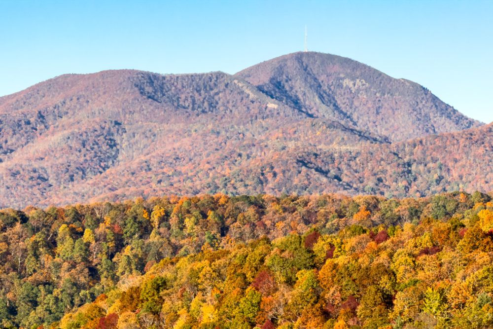
The highest peak in the east, looking nice with a little fall color mixing in among the spruce and fir.
#mtmitchell #northcarolina #blackmountains
#mtmitchell #northcarolina #blackmountains

October 1, 2025 at 2:12 PM
The highest peak in the east, looking nice with a little fall color mixing in among the spruce and fir.
#mtmitchell #northcarolina #blackmountains
#mtmitchell #northcarolina #blackmountains
Too many pickles? Want to save them for later? You need a...

September 17, 2025 at 2:40 PM
Too many pickles? Want to save them for later? You need a...
Are you a horse? Need a place to just kick back and rest for a while? Try a...

September 12, 2025 at 1:00 PM
Are you a horse? Need a place to just kick back and rest for a while? Try a...