


Cemali Altuntas
@cemalialtuntas.bsky.social
Visiting Researcher at National Oceanography Centre Liverpool | 🎓 PhD in Geomatics | 📊 Research Assistant | Yildiz Technical University
🧠 AI & Tech Enthusiast | 💻 Coding | Philosophy | 🌐 #GNSS #Geodesy #AI
🧠 AI & Tech Enthusiast | 💻 Coding | Philosophy | 🌐 #GNSS #Geodesy #AI
Reposted by Cemali Altuntas

🚀 It's launch day for @esaearth.esa.int's HydroGNSS satellite along with #IrideSpazio and #Iceye satellites.
Tune in today, 26 November, from 18:01 GMT/19:01 CET, to watch the liftoff live on #ESAwebTV.
📺 watch.esa.int
@ukspaceagency.bsky.social
Tune in today, 26 November, from 18:01 GMT/19:01 CET, to watch the liftoff live on #ESAwebTV.
📺 watch.esa.int
@ukspaceagency.bsky.social

November 26, 2025 at 5:27 PM
🚀 It's launch day for @esaearth.esa.int's HydroGNSS satellite along with #IrideSpazio and #Iceye satellites.
Tune in today, 26 November, from 18:01 GMT/19:01 CET, to watch the liftoff live on #ESAwebTV.
📺 watch.esa.int
@ukspaceagency.bsky.social
Tune in today, 26 November, from 18:01 GMT/19:01 CET, to watch the liftoff live on #ESAwebTV.
📺 watch.esa.int
@ukspaceagency.bsky.social
For those interested in GNSS-IR: the tropospheric height bias can significantly affect sea-level estimates. Here’s an example from the AC12 station in Alaska (~68 m above sea level). The difference between results with (blue) and without (orange) tropospheric correction is clear.
#GNSSIR #SeaLevel
#GNSSIR #SeaLevel

September 3, 2025 at 12:21 AM
Reposted by Cemali Altuntas
Tsunamis in Hawaii. Heights in metres. Notice how the first wave wasn't the biggest. Real time data at www.ioc-sealevelmonitoring.org/station.php?...
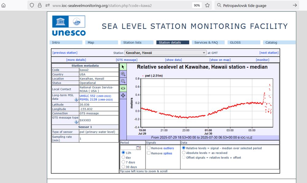
July 30, 2025 at 6:59 AM
Tsunamis in Hawaii. Heights in metres. Notice how the first wave wasn't the biggest. Real time data at www.ioc-sealevelmonitoring.org/station.php?...
I’m happy to announce my new academic portfolio website!
You can find details about my academic background, a list of my publications, projects, and software, as well as my contact information. I also plan to release open-source, web-based GNSS-IR tools soon.
cemalialtuntas.github.io
You can find details about my academic background, a list of my publications, projects, and software, as well as my contact information. I also plan to release open-source, web-based GNSS-IR tools soon.
cemalialtuntas.github.io
Cemali Altuntas - Researcher & Geomatics Engineer
cemalialtuntas.github.io
February 8, 2025 at 10:45 AM
I’m happy to announce my new academic portfolio website!
You can find details about my academic background, a list of my publications, projects, and software, as well as my contact information. I also plan to release open-source, web-based GNSS-IR tools soon.
cemalialtuntas.github.io
You can find details about my academic background, a list of my publications, projects, and software, as well as my contact information. I also plan to release open-source, web-based GNSS-IR tools soon.
cemalialtuntas.github.io