


Ceci
@cecil2014.bsky.social
Let's wait and see...Jan 2025
How it's going for your? Jul 2025
How it's going for your? Jul 2025
Reposted by Ceci

My biggest takeaways from the 2025 Atlantic hurricane season www.nbcmiami.com/weather/hurr...

November 25, 2025 at 12:30 AM
My biggest takeaways from the 2025 Atlantic hurricane season www.nbcmiami.com/weather/hurr...
Reposted by Ceci

“A promise of a vote on healthcare” is nothing

November 9, 2025 at 8:10 PM
“A promise of a vote on healthcare” is nothing
Reposted by Ceci

Breaking: Abigail Spanberger wins Virginia Governor race, flipping the seat from red to blue.
(Source: @decisiondeskhq.bsky.social)
(Source: @decisiondeskhq.bsky.social)

November 5, 2025 at 12:35 AM
Breaking: Abigail Spanberger wins Virginia Governor race, flipping the seat from red to blue.
(Source: @decisiondeskhq.bsky.social)
(Source: @decisiondeskhq.bsky.social)
Reposted by Ceci
Breaking: Ghazala Hashmi wins Virginia Lieutenant Governor race, flipping the seat from red to blue.
(Source: @decisiondeskhq.bsky.social)
(Source: @decisiondeskhq.bsky.social)

November 5, 2025 at 12:36 AM
Breaking: Ghazala Hashmi wins Virginia Lieutenant Governor race, flipping the seat from red to blue.
(Source: @decisiondeskhq.bsky.social)
(Source: @decisiondeskhq.bsky.social)
Reposted by Ceci

Abigail Spanberger just kicked off the blue wave!! Huge Democratic flip!

November 5, 2025 at 12:37 AM
Abigail Spanberger just kicked off the blue wave!! Huge Democratic flip!
Reposted by Ceci
Thank you @cleoinstitute.bsky.social for the Circle of Change Award: “At a time when climate coverage faces unprecedented political pressure and censorship, John and the…team of @nbcmiami.com & Telemundo 51 continue to lead with science-driven facts and courage.” www.nbcmiami.com/news/local/j...

October 31, 2025 at 11:26 PM
Thank you @cleoinstitute.bsky.social for the Circle of Change Award: “At a time when climate coverage faces unprecedented political pressure and censorship, John and the…team of @nbcmiami.com & Telemundo 51 continue to lead with science-driven facts and courage.” www.nbcmiami.com/news/local/j...
Reposted by Ceci
The first earlier standard time #sunrise over Biscayne Bay was nice. (end of #daylightsavingtime)

November 2, 2025 at 3:16 PM
The first earlier standard time #sunrise over Biscayne Bay was nice. (end of #daylightsavingtime)
Reposted by Ceci
Same, same.
“Forty years later, when I look at satellite imagery and other data on hurricanes and extreme weather, I often cannot believe my eyes. Most of these mind-boggling events have a potential link to climate change.” 🎁🔗
www.nytimes.com/2025/10/29/o...
“Forty years later, when I look at satellite imagery and other data on hurricanes and extreme weather, I often cannot believe my eyes. Most of these mind-boggling events have a potential link to climate change.” 🎁🔗
www.nytimes.com/2025/10/29/o...

Opinion | Hurricane Melissa Maxed Out What Scientists Thought Was Possible
www.nytimes.com
October 29, 2025 at 8:49 PM
Same, same.
“Forty years later, when I look at satellite imagery and other data on hurricanes and extreme weather, I often cannot believe my eyes. Most of these mind-boggling events have a potential link to climate change.” 🎁🔗
www.nytimes.com/2025/10/29/o...
“Forty years later, when I look at satellite imagery and other data on hurricanes and extreme weather, I often cannot believe my eyes. Most of these mind-boggling events have a potential link to climate change.” 🎁🔗
www.nytimes.com/2025/10/29/o...
Reposted by Ceci
"Extreme weather events fueled by climate change are increasing and making me change. I’ve always been authentic [...] but I can no longer be non-alarmist. People need to realize that this is not going to stop until we cut down on greenhouse gas [emissions]." @msnbc.com www.msnbc.com/ana-cabrera-...

Meteorologist becomes emotional reporting on strength of Hurricane Melissa
Hurricane Melissa is slamming into Cuba and taking aim at the Bahamas after devastating Jamaica. MSNBC Climate Reporter Moses Small has our latest forecast and WTVJ Meteorologist Hurricane Specialist ...
www.msnbc.com
October 29, 2025 at 4:00 PM
"Extreme weather events fueled by climate change are increasing and making me change. I’ve always been authentic [...] but I can no longer be non-alarmist. People need to realize that this is not going to stop until we cut down on greenhouse gas [emissions]." @msnbc.com www.msnbc.com/ana-cabrera-...
Reposted by Ceci
At NBC 6 since 4 am and until Melissa’s landfall this morning. Impacts in Jamaica are increasing as their strongest hurricane on record approaches. Winds 175 mph (280 km/hr) with gust factor of 1.5x➕ speeded up by hills & mountains. 13 ft (4 m) storm surge. 30-40 inches (1000 mm) storm total precip
October 28, 2025 at 11:43 AM
At NBC 6 since 4 am and until Melissa’s landfall this morning. Impacts in Jamaica are increasing as their strongest hurricane on record approaches. Winds 175 mph (280 km/hr) with gust factor of 1.5x➕ speeded up by hills & mountains. 13 ft (4 m) storm surge. 30-40 inches (1000 mm) storm total precip
Reposted by Ceci
"This is going to be the worst disaster in the history of #Jamaica. And what I’m worried about is the long term, the lasting effects of the hurricane upon their region." As seen earlier on @camanpour.bsky.social @cnnipr.bsky.social
and today on @pbs.org 📺 www.cnn.com/2025/10/28/t...
and today on @pbs.org 📺 www.cnn.com/2025/10/28/t...

‘Hurricanes don’t just take lives, they ruin lives’: Meteorologist reacts to Melissa | CNN
John Morales, meteorologist for ClimData, speaks with Bianna Golodryga about Hurricane Melissa, the strongest storm ever to hit Jamaica.
www.cnn.com
October 28, 2025 at 9:15 PM
"This is going to be the worst disaster in the history of #Jamaica. And what I’m worried about is the long term, the lasting effects of the hurricane upon their region." As seen earlier on @camanpour.bsky.social @cnnipr.bsky.social
and today on @pbs.org 📺 www.cnn.com/2025/10/28/t...
and today on @pbs.org 📺 www.cnn.com/2025/10/28/t...
Reposted by Ceci
During Melissa’s rapid intensification the storm drifted slowly over exceptionally warm ocean waters that were 1.4°C (2.5°F) warmer than average — these conditions were made up to 700 times more likely because of human-caused climate change. (via @climatecentral.org) 1/2

October 28, 2025 at 12:58 AM
During Melissa’s rapid intensification the storm drifted slowly over exceptionally warm ocean waters that were 1.4°C (2.5°F) warmer than average — these conditions were made up to 700 times more likely because of human-caused climate change. (via @climatecentral.org) 1/2
Reposted by Ceci
"The NOAA aircraft left the storm early after
experiencing severe turbulence in the southwestern eyewall."
These men and women are not being paid due to the US government shutdown. Not to mention that according to AOML's director emeritus Robert Atlas, they are down 40-50% staff. #Melissa
experiencing severe turbulence in the southwestern eyewall."
These men and women are not being paid due to the US government shutdown. Not to mention that according to AOML's director emeritus Robert Atlas, they are down 40-50% staff. #Melissa
October 27, 2025 at 3:49 PM
"The NOAA aircraft left the storm early after
experiencing severe turbulence in the southwestern eyewall."
These men and women are not being paid due to the US government shutdown. Not to mention that according to AOML's director emeritus Robert Atlas, they are down 40-50% staff. #Melissa
experiencing severe turbulence in the southwestern eyewall."
These men and women are not being paid due to the US government shutdown. Not to mention that according to AOML's director emeritus Robert Atlas, they are down 40-50% staff. #Melissa
Reposted by Ceci
Pressure down to 908 millibars, making #Melissa already the 11th strongest #hurricane on record in the Atlantic. It is still strengthening. Next on the list are Mitch (1998) and Dean (2007) at 905 mb. Sustained winds are up to 165 mph (270 km/hr). Topography can accelerate 1.5x✚

October 27, 2025 at 3:50 PM
Pressure down to 908 millibars, making #Melissa already the 11th strongest #hurricane on record in the Atlantic. It is still strengthening. Next on the list are Mitch (1998) and Dean (2007) at 905 mb. Sustained winds are up to 165 mph (270 km/hr). Topography can accelerate 1.5x✚
Reposted by Ceci
Doing this on a moonless night can't be fun. Pressure dropping precipitously, which will lead to continued strengthening. #Melissa is shooting for Category 5 intensity—third in Atlantic this year! It's likely to reach it. All signs point to a landfall in #Jamaica very early Tuesday. #HurricaneAlert


October 26, 2025 at 11:46 PM
Doing this on a moonless night can't be fun. Pressure dropping precipitously, which will lead to continued strengthening. #Melissa is shooting for Category 5 intensity—third in Atlantic this year! It's likely to reach it. All signs point to a landfall in #Jamaica very early Tuesday. #HurricaneAlert
Reposted by Ceci
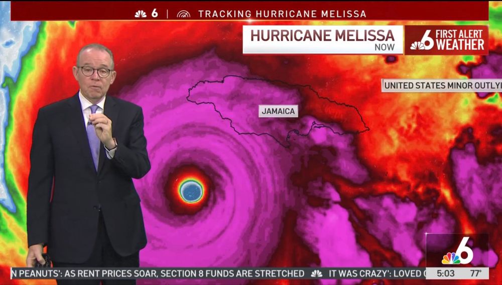
"Needless to say there is a very serious situation in terms of catastrophic rainfall wind and storm surge hazards for Jamaica and preparations should be rushed to completion in the area"
NHC explicitly calling for #Melissa to be a Cat 5 #hurricane on approach to #Jamaica (img @bmcnoldy.bsky.social)
NHC explicitly calling for #Melissa to be a Cat 5 #hurricane on approach to #Jamaica (img @bmcnoldy.bsky.social)
October 25, 2025 at 9:20 PM
"Needless to say there is a very serious situation in terms of catastrophic rainfall wind and storm surge hazards for Jamaica and preparations should be rushed to completion in the area"
NHC explicitly calling for #Melissa to be a Cat 5 #hurricane on approach to #Jamaica (img @bmcnoldy.bsky.social)
NHC explicitly calling for #Melissa to be a Cat 5 #hurricane on approach to #Jamaica (img @bmcnoldy.bsky.social)
Reposted by Ceci
Over the past 21 hours Hurricane #Melissa has undergone rapid intensification (RI). Nearly 80% of major hurricanes go through RI cycles to attain their devastating intensities. In the case of this cyclone, I believe we'll see Extreme RI with a gain of 58 mph or more in 24 hours. #Jamaica
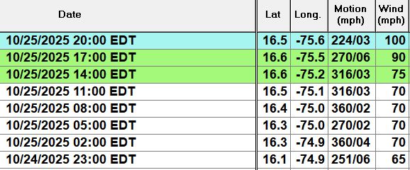
October 26, 2025 at 1:22 AM
Reposted by Ceci
Category 4 🚨
Major Hurricane Melissa
5:00 AM EDT Sun Oct 26
Location: 16.3°N 76.3°W
Moving: W at 5 mph
Min pressure: 944 mb
Max sustained: 140 mph
(image via @tropicaltidbits.bsky.social)
Major Hurricane Melissa
5:00 AM EDT Sun Oct 26
Location: 16.3°N 76.3°W
Moving: W at 5 mph
Min pressure: 944 mb
Max sustained: 140 mph
(image via @tropicaltidbits.bsky.social)
October 26, 2025 at 9:02 AM
Category 4 🚨
Major Hurricane Melissa
5:00 AM EDT Sun Oct 26
Location: 16.3°N 76.3°W
Moving: W at 5 mph
Min pressure: 944 mb
Max sustained: 140 mph
(image via @tropicaltidbits.bsky.social)
Major Hurricane Melissa
5:00 AM EDT Sun Oct 26
Location: 16.3°N 76.3°W
Moving: W at 5 mph
Min pressure: 944 mb
Max sustained: 140 mph
(image via @tropicaltidbits.bsky.social)
Reposted by Ceci
I'm awaiting the official declaration that Melissa is a hurricane. The satellite image shows an initial slow trend for a west motion. But clouds still extend across most of Hispaniola with rain (under the brightest clouds) still near the Dominican Republic. Over 20" of rain has fallen. #Melissa
October 25, 2025 at 3:52 PM
I'm awaiting the official declaration that Melissa is a hurricane. The satellite image shows an initial slow trend for a west motion. But clouds still extend across most of Hispaniola with rain (under the brightest clouds) still near the Dominican Republic. Over 20" of rain has fallen. #Melissa
Reposted by Ceci
Melissa suddenly has acquired that look. No sooner did the hostile wind shear relax than the first rapid intensification cycle began. I fully expect +35 mph or more in 24 hours going back to 11 am. Water temperatures are top 3 hottest ever recorded. Yet another Cat 4-5 forming. #Melissa
October 24, 2025 at 6:10 PM
Melissa suddenly has acquired that look. No sooner did the hostile wind shear relax than the first rapid intensification cycle began. I fully expect +35 mph or more in 24 hours going back to 11 am. Water temperatures are top 3 hottest ever recorded. Yet another Cat 4-5 forming. #Melissa
Reposted by Ceci
Thu 4 pm: The first rain gauge exceeding 300 millimeters of rain caused by #Melissa (starting Tuesday) is WeatherFlow station (Tempest instrument) no. 132600 located in Santo Domingo near Avenida Independencia in Jardines del Sur. Total 305.4mm = 12.02". Excessive rain will continue.

October 23, 2025 at 8:28 PM
Thu 4 pm: The first rain gauge exceeding 300 millimeters of rain caused by #Melissa (starting Tuesday) is WeatherFlow station (Tempest instrument) no. 132600 located in Santo Domingo near Avenida Independencia in Jardines del Sur. Total 305.4mm = 12.02". Excessive rain will continue.
Reposted by Ceci
“It’s not out of the question that three feet of rain could accumulate before it’s all said and done.” #Melissa
www.nbcmiami.com/weather/hurr...
www.nbcmiami.com/weather/hurr...

Tropical Storm Melissa, expected to rapidly intensify, and its worrying impacts: John Morales
Melissa’s menace to the Greater Antilles is growing.
www.nbcmiami.com
October 24, 2025 at 1:35 AM
“It’s not out of the question that three feet of rain could accumulate before it’s all said and done.” #Melissa
www.nbcmiami.com/weather/hurr...
www.nbcmiami.com/weather/hurr...
Reposted by Ceci

They don’t GAF about the Constitution, and they’ll do whatever it takes to keep Trump breathing long enough to seize a third term.
So when you start thinking your vote doesn’t matter, remember this: they know it does. That’s why they’re trying to take it from you.
This isn’t going to end well.
So when you start thinking your vote doesn’t matter, remember this: they know it does. That’s why they’re trying to take it from you.
This isn’t going to end well.
October 24, 2025 at 3:41 AM
They don’t GAF about the Constitution, and they’ll do whatever it takes to keep Trump breathing long enough to seize a third term.
So when you start thinking your vote doesn’t matter, remember this: they know it does. That’s why they’re trying to take it from you.
This isn’t going to end well.
So when you start thinking your vote doesn’t matter, remember this: they know it does. That’s why they’re trying to take it from you.
This isn’t going to end well.
Reposted by Ceci
Thanks to @burgwx.bsky.social this image contains all tracks from last night’s model ensembles (both physical and AI) for newly formed #Melissa. Any track along or to the right of the mean (black line) spells days of excessive rain and life threatening floods in Haiti and parts of the Dominican Rep.

October 21, 2025 at 2:42 PM
Thanks to @burgwx.bsky.social this image contains all tracks from last night’s model ensembles (both physical and AI) for newly formed #Melissa. Any track along or to the right of the mean (black line) spells days of excessive rain and life threatening floods in Haiti and parts of the Dominican Rep.
Reposted by Ceci
The models that don't are the Canadian (CMC), the German (ICON), and the European (ECMWF). If this were far away and there was more time to evaluate, I wouldn't have raised alarm so soon. But if #Melissa hits Haiti or the Dominican Republic, we're talking about Thursday! 2/2 fin #98L


October 20, 2025 at 8:18 PM