


The Cartography and Geographic Information Society
@carto-giscience.bsky.social
The Cartography and Geographic Information Society supports research, education, and practice to improve the understanding, creation, analysis, and use of maps and geographic information to support effective decision-making and improve the quality of life.
Lastly, Eric Delmelle is stepping down as Editor-in-Chief with Angela Yao stepping up to take his place - thank you Eric and Angela. And finally, thank you to our amazing 215 reviewers who help us make the journal what it is. doi.org/10.1080/1523...

November 12, 2025 at 11:07 AM
Lastly, Eric Delmelle is stepping down as Editor-in-Chief with Angela Yao stepping up to take his place - thank you Eric and Angela. And finally, thank you to our amazing 215 reviewers who help us make the journal what it is. doi.org/10.1080/1523...
New article! Lucinda Roberts and colleagues model global historic sailing routes using a least-cost surface analysis, #GISchat doi.org/10.1080/1523...

Global-TRANSIT: modeling global historic sailing using a least-cost surface analysis
Cost-surface analyses in geographic information systems (GIS) can be a useful tool for approximating the travel of historic sailing ships to fill gaps in the historic record. We present the Global-...
doi.org
November 12, 2025 at 11:07 AM
New article! Lucinda Roberts and colleagues model global historic sailing routes using a least-cost surface analysis, #GISchat doi.org/10.1080/1523...
New article! Angeliki Grammatikaki and colleagues present a new automated workflow to represent landmark trees in digital 3D maps, and a related user study doi.org/10.1080/1523... #GISchat #OpenAccess

November 12, 2025 at 11:06 AM
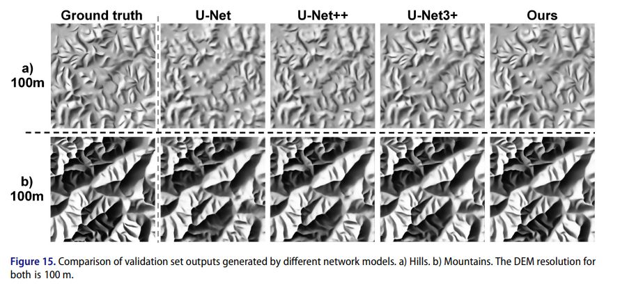
New article! Wenping Jiang and colleagues how to create small-scale Swiss-style relief
shading using a end-to-end relief shading neural network model #GISchat doi.org/10.1080/1523... Data and code at doi.org/10.6084/m9.f...
shading using a end-to-end relief shading neural network model #GISchat doi.org/10.1080/1523... Data and code at doi.org/10.6084/m9.f...
November 12, 2025 at 11:06 AM
Fascinating new article from Oihana Mitxelena-Hoyos & José-Lázaro Amaro-Mellado, evaluating labelling methods in bilingual maps, with a case study from Euskadi, Spain, doi.org/10.1080/1523... #OpenAccess #GISchat
Impact of cartographic and labeling standards on the dissemination of Toponymy: particularities of bilingual regions. A case study: Euskadi, Spain
Toponymy constitutes a system of literal location, which involves the understanding between linguistic and cartographic norms for effective communication. This complexity increases in bilingual ter...
doi.org
November 12, 2025 at 11:06 AM
Fascinating new article from Oihana Mitxelena-Hoyos & José-Lázaro Amaro-Mellado, evaluating labelling methods in bilingual maps, with a case study from Euskadi, Spain, doi.org/10.1080/1523... #OpenAccess #GISchat
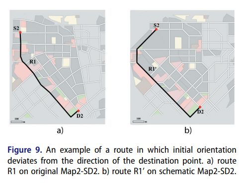
Fantastic new article looking at whether schematic maps (e.g. the London Tube map) can help with pedestrian route planning, from Ruyu Dai and colleagues, #GISchat doi.org/10.1080/1523...
November 12, 2025 at 11:05 AM
Fantastic new article looking at whether schematic maps (e.g. the London Tube map) can help with pedestrian route planning, from Ruyu Dai and colleagues, #GISchat doi.org/10.1080/1523...
New article! How to choose the best hue range for sequential color schemes on choropleth maps? Taisheng Chen and colleagues investigate, and present results of their evaluation, doi.org/10.1080/1523... #GISchat

November 12, 2025 at 11:04 AM
Taisheng Chen, Kun Hu et al. present a new way to automatically enhance qualitative color schemes for color vision deficiency, doi.org/10.1080/1523... #GISchat

November 12, 2025 at 11:04 AM
Taisheng Chen, Kun Hu et al. present a new way to automatically enhance qualitative color schemes for color vision deficiency, doi.org/10.1080/1523... #GISchat
Great new article from Julian Keil and colleagues, looking at the landmark attraction effect, where locations are memorized closer to prominent landmarks than they actually are. The symbol used also has an impact on this. doi.org/10.1080/1523... #GISchat #OpenAccess

November 12, 2025 at 11:04 AM
Great new article from Julian Keil and colleagues, looking at the landmark attraction effect, where locations are memorized closer to prominent landmarks than they actually are. The symbol used also has an impact on this. doi.org/10.1080/1523... #GISchat #OpenAccess