


The Bookreader
@booksandlanguages.bsky.social
I'm just a person who likes reading books, watching movies, and talking about the wider world.
#NewProfilePicture
Here is a graph that I found depicting the flags of various French-speaking countries.
Which of these would you like to visit?
Here is a graph that I found depicting the flags of various French-speaking countries.
Which of these would you like to visit?

October 7, 2025 at 12:38 AM
#NewProfilePicture
Here is a graph that I found depicting the flags of various French-speaking countries.
Which of these would you like to visit?
Here is a graph that I found depicting the flags of various French-speaking countries.
Which of these would you like to visit?
I recently founded this 1883 map of Philadelphia, PA.
What are your thoughts on this?
What are your thoughts on this?

June 30, 2025 at 11:09 PM
I recently founded this 1883 map of Philadelphia, PA.
What are your thoughts on this?
What are your thoughts on this?
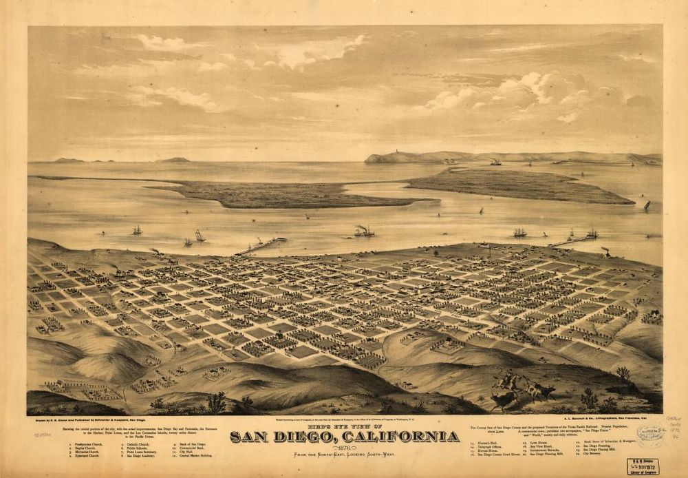
In case you wanted to learn something interesting, here are some late 19th-century maps of #SanDiego County.
What strikes you about these maps, especially in terms of how San Diego has grown in population since the times that these maps were published?
What strikes you about these maps, especially in terms of how San Diego has grown in population since the times that these maps were published?


June 30, 2025 at 11:01 PM
In case you wanted to learn something interesting, here are some late 19th-century maps of #SanDiego County.
What strikes you about these maps, especially in terms of how San Diego has grown in population since the times that these maps were published?
What strikes you about these maps, especially in terms of how San Diego has grown in population since the times that these maps were published?

In light of April 19 being #DutchAmericanFriendshipDay, I was thinking:
Can you REALLY speak of a "Dutch-speaking world" in the same way that you do of English- or French-speaking ones, given how c. 24 million people worldwide speak Dutch among 3 sovereign countries (🇳🇱🇧🇪 and 🇸🇷)?
🇳🇱🇧🇪🇸🇷🇦🇼🇨🇼🇸🇽🇧🇶
Can you REALLY speak of a "Dutch-speaking world" in the same way that you do of English- or French-speaking ones, given how c. 24 million people worldwide speak Dutch among 3 sovereign countries (🇳🇱🇧🇪 and 🇸🇷)?
🇳🇱🇧🇪🇸🇷🇦🇼🇨🇼🇸🇽🇧🇶

April 16, 2025 at 10:31 PM
In light of April 19 being #DutchAmericanFriendshipDay, I was thinking:
Can you REALLY speak of a "Dutch-speaking world" in the same way that you do of English- or French-speaking ones, given how c. 24 million people worldwide speak Dutch among 3 sovereign countries (🇳🇱🇧🇪 and 🇸🇷)?
🇳🇱🇧🇪🇸🇷🇦🇼🇨🇼🇸🇽🇧🇶
Can you REALLY speak of a "Dutch-speaking world" in the same way that you do of English- or French-speaking ones, given how c. 24 million people worldwide speak Dutch among 3 sovereign countries (🇳🇱🇧🇪 and 🇸🇷)?
🇳🇱🇧🇪🇸🇷🇦🇼🇨🇼🇸🇽🇧🇶
Here is a book that I decided to read over the next week or so, since this weekend marks #DutchAmericanFriendshipDay AND April 24 is the birthday of William the Silent.
#BookSky #History #Netherlands
🇳🇱🇧🇪🇱🇺🇪🇸🇩🇪🇫🇷
🟠🔴⚪🔵🔴🟡⚫
#BookSky #History #Netherlands
🇳🇱🇧🇪🇱🇺🇪🇸🇩🇪🇫🇷
🟠🔴⚪🔵🔴🟡⚫

April 16, 2025 at 6:50 PM
Here is a book that I decided to read over the next week or so, since this weekend marks #DutchAmericanFriendshipDay AND April 24 is the birthday of William the Silent.
#BookSky #History #Netherlands
🇳🇱🇧🇪🇱🇺🇪🇸🇩🇪🇫🇷
🟠🔴⚪🔵🔴🟡⚫
#BookSky #History #Netherlands
🇳🇱🇧🇪🇱🇺🇪🇸🇩🇪🇫🇷
🟠🔴⚪🔵🔴🟡⚫

April 16, 2025 at 2:40 PM
#NewProfilePicture
In case you wanted some laughs and/or lessons in French, I decided to update my profile picture.
Yes, I know it is very wordy.
In case you wanted some laughs and/or lessons in French, I decided to update my profile picture.
Yes, I know it is very wordy.

April 12, 2025 at 4:21 PM
#NewProfilePicture
In case you wanted some laughs and/or lessons in French, I decided to update my profile picture.
Yes, I know it is very wordy.
In case you wanted some laughs and/or lessons in French, I decided to update my profile picture.
Yes, I know it is very wordy.
In case you wanted some laughs, here are a couple of jokes courtesy of thelanguagenerds.com.
Source: thelanguagenerds.com/2020/27-joke...
Source: thelanguagenerds.com/2020/27-joke...

April 12, 2025 at 4:19 PM
In case you wanted some laughs, here are a couple of jokes courtesy of thelanguagenerds.com.
Source: thelanguagenerds.com/2020/27-joke...
Source: thelanguagenerds.com/2020/27-joke...
Here are a couple of maps of Seattle from the late 19th century.
What are some things about these maps that stand out to you?
What are some things about these maps that stand out to you?


April 6, 2025 at 1:24 AM
Here are a couple of maps of Seattle from the late 19th century.
What are some things about these maps that stand out to you?
What are some things about these maps that stand out to you?
Here are two maps of 1891 depicting the City of Houston, Texas.
The first depicts the City of Houston and surrounding surveys in 1891.
The second depicts the City of Houston from an aerial perspective.
What are your thoughts on these maps?
The first depicts the City of Houston and surrounding surveys in 1891.
The second depicts the City of Houston from an aerial perspective.
What are your thoughts on these maps?


April 6, 2025 at 12:52 AM
Here are two maps of 1891 depicting the City of Houston, Texas.
The first depicts the City of Houston and surrounding surveys in 1891.
The second depicts the City of Houston from an aerial perspective.
What are your thoughts on these maps?
The first depicts the City of Houston and surrounding surveys in 1891.
The second depicts the City of Houston from an aerial perspective.
What are your thoughts on these maps?
Here are a couple of 19th century maps of the Detroit area.
In the case of the people of Detroit in 1860, can you imagine navigating around the area without the very cars that would make the city world-famous?
In the case of the people of Detroit in 1860, can you imagine navigating around the area without the very cars that would make the city world-famous?


April 1, 2025 at 3:07 PM
Here are a couple of 19th century maps of the Detroit area.
In the case of the people of Detroit in 1860, can you imagine navigating around the area without the very cars that would make the city world-famous?
In the case of the people of Detroit in 1860, can you imagine navigating around the area without the very cars that would make the city world-famous?
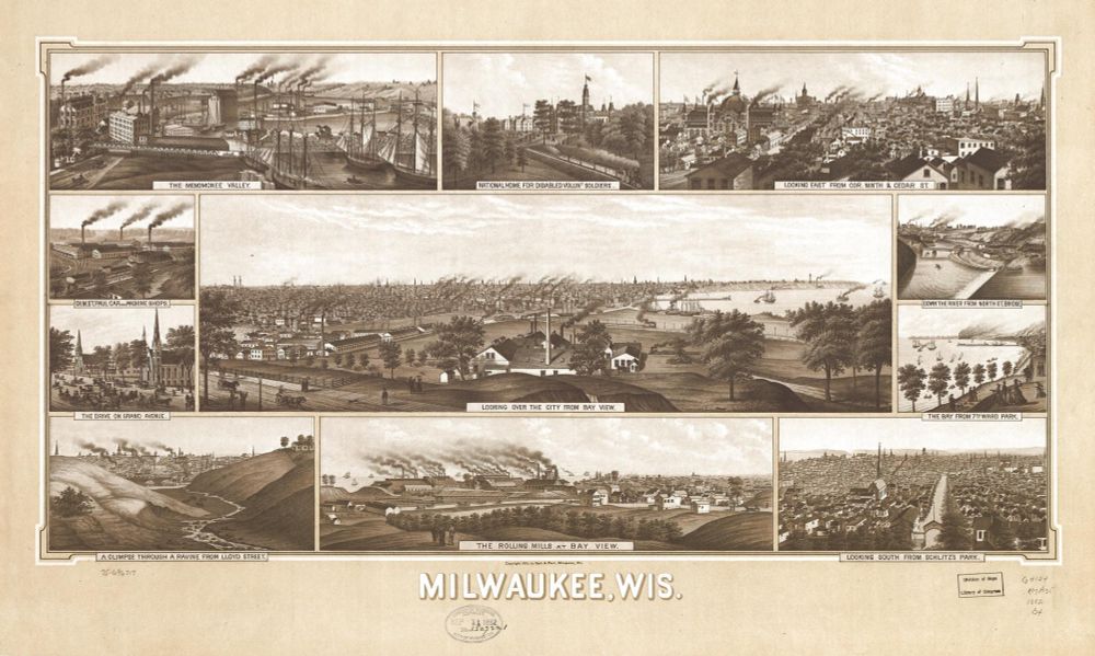
Over the last few weeks, I have shared historical maps of San Francisco, San Jose, Los Angeles, the Dallas-Fort Worth area, and Chicago - all world-famous and economically crucial cities in America.
However, I wanted to share these maps of a relatively lesser-known city in America:
Milwaukee, WI.
However, I wanted to share these maps of a relatively lesser-known city in America:
Milwaukee, WI.

April 1, 2025 at 2:51 PM
Over the last few weeks, I have shared historical maps of San Francisco, San Jose, Los Angeles, the Dallas-Fort Worth area, and Chicago - all world-famous and economically crucial cities in America.
However, I wanted to share these maps of a relatively lesser-known city in America:
Milwaukee, WI.
However, I wanted to share these maps of a relatively lesser-known city in America:
Milwaukee, WI.
I found these old maps of Chicago in the 1890s, courtesy of the Library of Congress.
What are your thoughts?
What are your thoughts?


March 30, 2025 at 6:22 PM
I found these old maps of Chicago in the 1890s, courtesy of the Library of Congress.
What are your thoughts?
What are your thoughts?
Since Easter is coming soon, I thought it would be interesting to read about the Crusades.
Hence, I decided to reread this book.
✝️☦️⛪☪️🏴🇫🇷🇪🇸🇵🇹🇩🇪🇮🇹🇻🇦🇮🇱🇵🇸🇱🇧🇸🇾🇯🇴🇪🇬
Hence, I decided to reread this book.
✝️☦️⛪☪️🏴🇫🇷🇪🇸🇵🇹🇩🇪🇮🇹🇻🇦🇮🇱🇵🇸🇱🇧🇸🇾🇯🇴🇪🇬

March 29, 2025 at 2:21 PM
Since Easter is coming soon, I thought it would be interesting to read about the Crusades.
Hence, I decided to reread this book.
✝️☦️⛪☪️🏴🇫🇷🇪🇸🇵🇹🇩🇪🇮🇹🇻🇦🇮🇱🇵🇸🇱🇧🇸🇾🇯🇴🇪🇬
Hence, I decided to reread this book.
✝️☦️⛪☪️🏴🇫🇷🇪🇸🇵🇹🇩🇪🇮🇹🇻🇦🇮🇱🇵🇸🇱🇧🇸🇾🇯🇴🇪🇬
In case you wanted to learn something, here is a 1707 Dutch map of the Gulf region in the Middle East. One thing that I found interesting is that the map uses the Italian term "Golfo di Bassora" (Gulf of Basra), in addition to the Latin term "Sinus Persicus" (Persian Gulf).
🇮🇷🇮🇶🇸🇦🇰🇼🇧🇭🇶🇦🇦🇪🇹🇷
🇮🇷🇮🇶🇸🇦🇰🇼🇧🇭🇶🇦🇦🇪🇹🇷

March 26, 2025 at 1:18 PM
In case you wanted to learn something, here is a 1707 Dutch map of the Gulf region in the Middle East. One thing that I found interesting is that the map uses the Italian term "Golfo di Bassora" (Gulf of Basra), in addition to the Latin term "Sinus Persicus" (Persian Gulf).
🇮🇷🇮🇶🇸🇦🇰🇼🇧🇭🇶🇦🇦🇪🇹🇷
🇮🇷🇮🇶🇸🇦🇰🇼🇧🇭🇶🇦🇦🇪🇹🇷
In fact, here is a map depicting how Los Angeles grew in territory during the second half of the 19th century.
Personally, I find it interesting that LA did not even have a port until the early 20th century, given its location on the West Coast.
Personally, I find it interesting that LA did not even have a port until the early 20th century, given its location on the West Coast.

March 11, 2025 at 4:43 PM
In fact, here is a map depicting how Los Angeles grew in territory during the second half of the 19th century.
Personally, I find it interesting that LA did not even have a port until the early 20th century, given its location on the West Coast.
Personally, I find it interesting that LA did not even have a port until the early 20th century, given its location on the West Coast.
Related to the 1875 image of San Francisco, here is an 1890 map of Santa Clara County (i.e., San Jose and its surrounding, the future home of Silicon Valley).
Little did anyone know that this then-agrarian area would become the hub of the world's most prominent tech industry.
#BayArea #California
Little did anyone know that this then-agrarian area would become the hub of the world's most prominent tech industry.
#BayArea #California

March 11, 2025 at 3:35 PM
Related to the 1875 image of San Francisco, here is an 1890 map of Santa Clara County (i.e., San Jose and its surrounding, the future home of Silicon Valley).
Little did anyone know that this then-agrarian area would become the hub of the world's most prominent tech industry.
#BayArea #California
Little did anyone know that this then-agrarian area would become the hub of the world's most prominent tech industry.
#BayArea #California

I found these maps of San Francisco and Los Angeles depicting how they looked during the 1870s.
What are some things that intrigue you about these images?
Personally, I find it interesting how much more dense and urban San Francisco was than the agarian Los Angeles. #California #LASky #SFSky
What are some things that intrigue you about these images?
Personally, I find it interesting how much more dense and urban San Francisco was than the agarian Los Angeles. #California #LASky #SFSky


March 11, 2025 at 2:48 PM
I found these maps of San Francisco and Los Angeles depicting how they looked during the 1870s.
What are some things that intrigue you about these images?
Personally, I find it interesting how much more dense and urban San Francisco was than the agarian Los Angeles. #California #LASky #SFSky
What are some things that intrigue you about these images?
Personally, I find it interesting how much more dense and urban San Francisco was than the agarian Los Angeles. #California #LASky #SFSky