


Bob Henson
@bhensonweather.bsky.social
Meteorologist and journalist. I cover wacky weather, changing climate, and how we live, love, work, get around, and dream.
Tonight’s stupendous aurora-fest as seen in Louisville CO. As always, the phone camera makes these far more vivid than they actually looked to the naked eye. Still plenty bright—the most colorful I’ve seen anywhere, anytime.


November 12, 2025 at 5:26 AM
Tonight’s stupendous aurora-fest as seen in Louisville CO. As always, the phone camera makes these far more vivid than they actually looked to the naked eye. Still plenty bright—the most colorful I’ve seen anywhere, anytime.
Mind-boggling amounts of rain are in the latest 4-day forecast, including localized totals that could exceed 30 inches in far western Haiti and 40 inches in far eastern Jamaica.
To state the obvious, flooding will be widespread and severe.
www.nhc.noaa.gov/refresh/grap...
To state the obvious, flooding will be widespread and severe.
www.nhc.noaa.gov/refresh/grap...

October 25, 2025 at 9:15 PM
Mind-boggling amounts of rain are in the latest 4-day forecast, including localized totals that could exceed 30 inches in far western Haiti and 40 inches in far eastern Jamaica.
To state the obvious, flooding will be widespread and severe.
www.nhc.noaa.gov/refresh/grap...
To state the obvious, flooding will be widespread and severe.
www.nhc.noaa.gov/refresh/grap...
See also the experts cited in our Sept 8 post below at @climateconnections.bsky.social. Among other things, midlatitude ocean and air temps have been incredibly warm, which distorts the normal global circulation and complicates hurricane/typhoon formation.
yaleclimateconnections.org/2025/09/anot...
yaleclimateconnections.org/2025/09/anot...

September 10, 2025 at 6:52 PM
See also the experts cited in our Sept 8 post below at @climateconnections.bsky.social. Among other things, midlatitude ocean and air temps have been incredibly warm, which distorts the normal global circulation and complicates hurricane/typhoon formation.
yaleclimateconnections.org/2025/09/anot...
yaleclimateconnections.org/2025/09/anot...
Much of the drought impact is related to the Southwest heating up as the planet warms (see NCEI prcp + temp gx below). The PDO normally swings back and forth over years>decades, so the PDO-related precip drop has been assumed to be mostly natural varability.
The new research finds otherwise: 3/4
The new research finds otherwise: 3/4


August 13, 2025 at 3:32 PM
Much of the drought impact is related to the Southwest heating up as the planet warms (see NCEI prcp + temp gx below). The PDO normally swings back and forth over years>decades, so the PDO-related precip drop has been assumed to be mostly natural varability.
The new research finds otherwise: 3/4
The new research finds otherwise: 3/4
The PDO strongly relates to precipitation in the US Southwest. When the PDO is in its negative mode—as it's been most of the time for 25 years now—it favors La Niña patterns and less rain (and mountain snow) for the SW, which has been in its worst megadrought in 1200 years. 2/4

August 13, 2025 at 3:32 PM
The PDO strongly relates to precipitation in the US Southwest. When the PDO is in its negative mode—as it's been most of the time for 25 years now—it favors La Niña patterns and less rain (and mountain snow) for the SW, which has been in its worst megadrought in 1200 years. 2/4
In July, the Pacific Decadal Oscillation hit its lowest monthly value in **171 years** of data. The current string of negative readings is the longest on record.
How does this related to major research just out on climate change and prolonged SW US drought? 1/4
www.ncei.noaa.gov/access/monit...
How does this related to major research just out on climate change and prolonged SW US drought? 1/4
www.ncei.noaa.gov/access/monit...

August 13, 2025 at 3:32 PM
In July, the Pacific Decadal Oscillation hit its lowest monthly value in **171 years** of data. The current string of negative readings is the longest on record.
How does this related to major research just out on climate change and prolonged SW US drought? 1/4
www.ncei.noaa.gov/access/monit...
How does this related to major research just out on climate change and prolonged SW US drought? 1/4
www.ncei.noaa.gov/access/monit...
Across 75 years of data at Everglades Nat'l Park, 12 out of 31 days in July have set their record-warm daily low temperatures since 2020. All of these are at least 81°F.
July lows in the Everglades region are now running 5°F above their early-20th century avg.
www.ncei.noaa.gov/access/monit...
July lows in the Everglades region are now running 5°F above their early-20th century avg.
www.ncei.noaa.gov/access/monit...

July 23, 2025 at 3:06 PM
Across 75 years of data at Everglades Nat'l Park, 12 out of 31 days in July have set their record-warm daily low temperatures since 2020. All of these are at least 81°F.
July lows in the Everglades region are now running 5°F above their early-20th century avg.
www.ncei.noaa.gov/access/monit...
July lows in the Everglades region are now running 5°F above their early-20th century avg.
www.ncei.noaa.gov/access/monit...
Yet more flash flood warnings w/heavy rain in and around Kerr County this Sun AM 7/13 thru late AM. A carbon copy of July 4 is not expected, but this will only hinder relief/recovery efforts.


July 13, 2025 at 2:08 PM
Yet more flash flood warnings w/heavy rain in and around Kerr County this Sun AM 7/13 thru late AM. A carbon copy of July 4 is not expected, but this will only hinder relief/recovery efforts.
[date corrected:]
This is painful to even contemplate, but there is a chance late Sat night 7/12-7/13 of 3"/hr rains and 9"+ totals near the hardest-hit areas in central Texas. From NOAA/WPC: "High Risk impacts cannot be ruled out locally."
www.wpc.ncep.noaa.gov/discussions/...
This is painful to even contemplate, but there is a chance late Sat night 7/12-7/13 of 3"/hr rains and 9"+ totals near the hardest-hit areas in central Texas. From NOAA/WPC: "High Risk impacts cannot be ruled out locally."
www.wpc.ncep.noaa.gov/discussions/...

July 13, 2025 at 4:17 AM
[date corrected:]
This is painful to even contemplate, but there is a chance late Sat night 7/12-7/13 of 3"/hr rains and 9"+ totals near the hardest-hit areas in central Texas. From NOAA/WPC: "High Risk impacts cannot be ruled out locally."
www.wpc.ncep.noaa.gov/discussions/...
This is painful to even contemplate, but there is a chance late Sat night 7/12-7/13 of 3"/hr rains and 9"+ totals near the hardest-hit areas in central Texas. From NOAA/WPC: "High Risk impacts cannot be ruled out locally."
www.wpc.ncep.noaa.gov/discussions/...
One more day: Mon flood risk just upgraded in central TX. NOAA/WPC: “Any storms that move across this
extremely vulnerable region will rapidly cause flash flooding, some
of which could be significant if cells repeat or stall over the
already hard-hit regions.”
www.wpc.ncep.noaa.gov/discussions/...
extremely vulnerable region will rapidly cause flash flooding, some
of which could be significant if cells repeat or stall over the
already hard-hit regions.”
www.wpc.ncep.noaa.gov/discussions/...
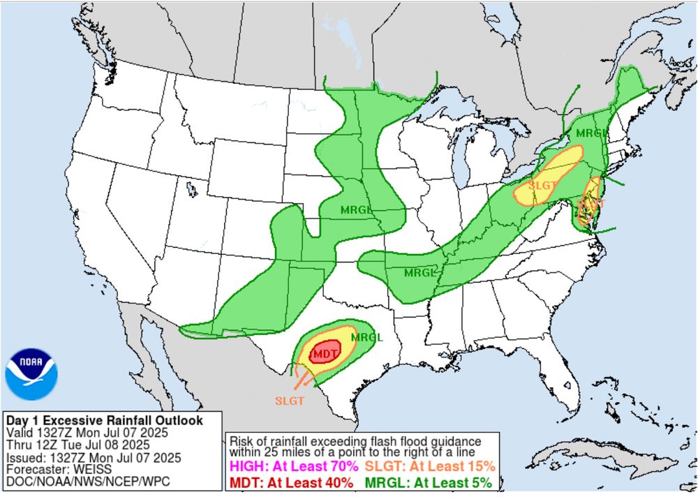
July 7, 2025 at 3:50 PM
One more day: Mon flood risk just upgraded in central TX. NOAA/WPC: “Any storms that move across this
extremely vulnerable region will rapidly cause flash flooding, some
of which could be significant if cells repeat or stall over the
already hard-hit regions.”
www.wpc.ncep.noaa.gov/discussions/...
extremely vulnerable region will rapidly cause flash flooding, some
of which could be significant if cells repeat or stall over the
already hard-hit regions.”
www.wpc.ncep.noaa.gov/discussions/...
It may seem counterintuitive, but some of the very hottest days in this region come on west or west-northwest breezes rather than southerly winds. The post explains why.

June 25, 2025 at 6:31 PM
It may seem counterintuitive, but some of the very hottest days in this region come on west or west-northwest breezes rather than southerly winds. The post explains why.
Multiple wind gusts in the 75-85 mph range at the NCAR Mesa Lab this morning (Thurs 5/15/25). More like a roaring winter downslope event than a spring breeze.
With most trees already leafed out now, it's also *loud*.
archive.eol.ucar.edu/cgi-bin/weat...
With most trees already leafed out now, it's also *loud*.
archive.eol.ucar.edu/cgi-bin/weat...

May 15, 2025 at 3:14 PM
Multiple wind gusts in the 75-85 mph range at the NCAR Mesa Lab this morning (Thurs 5/15/25). More like a roaring winter downslope event than a spring breeze.
With most trees already leafed out now, it's also *loud*.
archive.eol.ucar.edu/cgi-bin/weat...
With most trees already leafed out now, it's also *loud*.
archive.eol.ucar.edu/cgi-bin/weat...
On top of this severe-storm threat—with strong tornadoes possible on both Fri and Sat—there's an "extremely critical" wildfire threat on Fri (highest possible level) extending unusually far east in TX/OK into the Oklahoma City and Tulsa areas, even approaching DFW.
www.spc.noaa.gov/products/fir...
www.spc.noaa.gov/products/fir...

March 13, 2025 at 4:52 PM
On top of this severe-storm threat—with strong tornadoes possible on both Fri and Sat—there's an "extremely critical" wildfire threat on Fri (highest possible level) extending unusually far east in TX/OK into the Oklahoma City and Tulsa areas, even approaching DFW.
www.spc.noaa.gov/products/fir...
www.spc.noaa.gov/products/fir...
Quite a turnout today. My favorite sign:

March 3, 2025 at 10:17 PM
Quite a turnout today. My favorite sign:
We're off to the races in terms of fuel for the coming months of severe weather. The current Gulf-wide average SST of around 24C (75F) is a record for mid-Feb, and more typical of what you'd expect in late April.
kouya.has.arizona.edu/tropics/SSTm...
kouya.has.arizona.edu/tropics/SSTm...

February 14, 2025 at 3:57 PM
We're off to the races in terms of fuel for the coming months of severe weather. The current Gulf-wide average SST of around 24C (75F) is a record for mid-Feb, and more typical of what you'd expect in late April.
kouya.has.arizona.edu/tropics/SSTm...
kouya.has.arizona.edu/tropics/SSTm...
About 5 miles apart as the crow flies. See attached map.
Mesa Lab weather station = 1885 m (6184 ft)
Foothills Lab weather station = 1625 m (5331 ft)
More metadata here:
archive.eol.ucar.edu/cgi-bin/weat...
archive.eol.ucar.edu/cgi-bin/weat...
Mesa Lab weather station = 1885 m (6184 ft)
Foothills Lab weather station = 1625 m (5331 ft)
More metadata here:
archive.eol.ucar.edu/cgi-bin/weat...
archive.eol.ucar.edu/cgi-bin/weat...

January 21, 2025 at 4:53 PM
About 5 miles apart as the crow flies. See attached map.
Mesa Lab weather station = 1885 m (6184 ft)
Foothills Lab weather station = 1625 m (5331 ft)
More metadata here:
archive.eol.ucar.edu/cgi-bin/weat...
archive.eol.ucar.edu/cgi-bin/weat...
Mesa Lab weather station = 1885 m (6184 ft)
Foothills Lab weather station = 1625 m (5331 ft)
More metadata here:
archive.eol.ucar.edu/cgi-bin/weat...
archive.eol.ucar.edu/cgi-bin/weat...
Pretty good inversion right now, though! At 7:20 AM CST on 1/21/25:
NCAR Foothills Lab: -3.7F
NCAR Mesa Lab: +26.1F
NCAR Foothills Lab: -3.7F
NCAR Mesa Lab: +26.1F


January 21, 2025 at 2:29 PM
Pretty good inversion right now, though! At 7:20 AM CST on 1/21/25:
NCAR Foothills Lab: -3.7F
NCAR Mesa Lab: +26.1F
NCAR Foothills Lab: -3.7F
NCAR Mesa Lab: +26.1F
Both San Diego and downtown Los Angeles have gotten just 0.16" of rainfall since July 1. That's the lowest in 175 years of San Diego data, and tied for the lowest in 148 years of L.A. data. No rain whatesoever for the foreseeable future, and we're now at the height of the wet season.


January 16, 2025 at 4:19 PM
Both San Diego and downtown Los Angeles have gotten just 0.16" of rainfall since July 1. That's the lowest in 175 years of San Diego data, and tied for the lowest in 148 years of L.A. data. No rain whatesoever for the foreseeable future, and we're now at the height of the wet season.
Watch out on Sat, esp from central LA into central MS: “Tornadoes (some strong with at least EF2 damage possible), severe gusts and hail are expected today into tonight.”
www.spc.noaa.gov/products/out...
www.spc.noaa.gov/products/out...

December 28, 2024 at 5:40 PM
Watch out on Sat, esp from central LA into central MS: “Tornadoes (some strong with at least EF2 damage possible), severe gusts and hail are expected today into tonight.”
www.spc.noaa.gov/products/out...
www.spc.noaa.gov/products/out...
Thankfully, we got that major dose of moisture in November, so the preconditions aren't *quite* as bad this December
...but yeah :-/
droughtmonitor.unl.edu/Maps/Compare...
...but yeah :-/
droughtmonitor.unl.edu/Maps/Compare...

December 20, 2024 at 8:23 PM
Thankfully, we got that major dose of moisture in November, so the preconditions aren't *quite* as bad this December
...but yeah :-/
droughtmonitor.unl.edu/Maps/Compare...
...but yeah :-/
droughtmonitor.unl.edu/Maps/Compare...
The home fires will be burning over the holidays….and so will the U.S. atmosphere, it looks like.
🔥🔥🔥
www.cpc.ncep.noaa.gov/products/pre...
🔥🔥🔥
www.cpc.ncep.noaa.gov/products/pre...

December 17, 2024 at 4:06 AM
The home fires will be burning over the holidays….and so will the U.S. atmosphere, it looks like.
🔥🔥🔥
www.cpc.ncep.noaa.gov/products/pre...
🔥🔥🔥
www.cpc.ncep.noaa.gov/products/pre...
More than 4” of rain on Wed at the Providence RI airport! By far the wettest day in more than 10,000 winter days there (1904-present), topping 3.47” from Dec 26, 1969. Warmer climate is juicing atmos = more extreme rains, *esp* in NE US.
www.climatecentral.org/graphic/extr...
www.climatecentral.org/graphic/extr...

December 12, 2024 at 4:47 AM
More than 4” of rain on Wed at the Providence RI airport! By far the wettest day in more than 10,000 winter days there (1904-present), topping 3.47” from Dec 26, 1969. Warmer climate is juicing atmos = more extreme rains, *esp* in NE US.
www.climatecentral.org/graphic/extr...
www.climatecentral.org/graphic/extr...
Also part of the picture: Striking atmos warmth around the northern GoMex. Temp anomalies are +8F to > +10F for Nov 1-18 across the region. Mobile AL is running over 3F above all Nov 1-18 periods in 153 years of obs! The rest of Nov looks cooler.
www.cpc.ncep.noaa.gov/products/tan...
www.cpc.ncep.noaa.gov/products/tan...


November 19, 2024 at 6:03 PM
Also part of the picture: Striking atmos warmth around the northern GoMex. Temp anomalies are +8F to > +10F for Nov 1-18 across the region. Mobile AL is running over 3F above all Nov 1-18 periods in 153 years of obs! The rest of Nov looks cooler.
www.cpc.ncep.noaa.gov/products/tan...
www.cpc.ncep.noaa.gov/products/tan...
Not to mention that Caribbean-wide oceanic heat content is higher than it typically is at the September peak of hurricane season (per @bmcnoldy.bsky.social):

November 12, 2024 at 8:26 PM
Not to mention that Caribbean-wide oceanic heat content is higher than it typically is at the September peak of hurricane season (per @bmcnoldy.bsky.social):
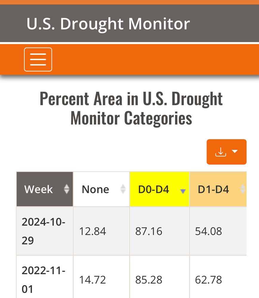
National-scale dryness will likely decline a bit by next week, but as of this week, 87% of the contiguous US is abnormally dry. That’s a record-high coverage in weekly US Drought Monitor data going back to 2000.
droughtmonitor.unl.edu/DmData/DataT...
droughtmonitor.unl.edu/DmData/DataT...
October 31, 2024 at 1:22 PM
National-scale dryness will likely decline a bit by next week, but as of this week, 87% of the contiguous US is abnormally dry. That’s a record-high coverage in weekly US Drought Monitor data going back to 2000.
droughtmonitor.unl.edu/DmData/DataT...
droughtmonitor.unl.edu/DmData/DataT...