


Benjamin Strick
@bendobrown.bsky.social
Investigator | Human Rights | Hybrid Wars
- Makes videos on maps, data & #OSINT
- Director of Investigations at @cen4infores.bsky.social
- Prev at BBC Africa Eye. Bellingcat contributor.
- Makes videos on maps, data & #OSINT
- Director of Investigations at @cen4infores.bsky.social
- Prev at BBC Africa Eye. Bellingcat contributor.
Open source documentation by our Sudan Witness team at CIR on mass displacement, detentions & killings during the RSF takeover of El Fasher and the commanders linked to them: www.info-res.org/reports/disp...


November 7, 2025 at 3:08 PM
Open source documentation by our Sudan Witness team at CIR on mass displacement, detentions & killings during the RSF takeover of El Fasher and the commanders linked to them: www.info-res.org/reports/disp...
This is the aftermath of Hurricane Melissa in Jamaica. Absolutely horrific level of destruction, all visible on NOAA imagery. View the map here: storms.ngs.noaa.gov/storms/melis...
November 3, 2025 at 1:52 PM
This is the aftermath of Hurricane Melissa in Jamaica. Absolutely horrific level of destruction, all visible on NOAA imagery. View the map here: storms.ngs.noaa.gov/storms/melis...
Analysis by our @cen4infores.bsky.social team has identified multiple execution videos involving RSF commander 'Abu Lulu' and other fighters shooting unarmed people at the site.

November 1, 2025 at 5:35 AM
Analysis by our @cen4infores.bsky.social team has identified multiple execution videos involving RSF commander 'Abu Lulu' and other fighters shooting unarmed people at the site.
New satellite imagery analysis from Yale shows detailed view of the site where footage showed RSF executing unarmed people in the berm just north of Sudan’s El Fasher.

November 1, 2025 at 5:31 AM
New satellite imagery analysis from Yale shows detailed view of the site where footage showed RSF executing unarmed people in the berm just north of Sudan’s El Fasher.
Our world glows differently after dark and NASA’s satellites see it all. From wars to disasters and even the movement of vessels.
So I made a tutorial on how you can read those patterns using night lights imagery. Watch it here: www.youtube.com/watch?v=x9JR...
So I made a tutorial on how you can read those patterns using night lights imagery. Watch it here: www.youtube.com/watch?v=x9JR...
October 23, 2025 at 9:26 AM
Our world glows differently after dark and NASA’s satellites see it all. From wars to disasters and even the movement of vessels.
So I made a tutorial on how you can read those patterns using night lights imagery. Watch it here: www.youtube.com/watch?v=x9JR...
So I made a tutorial on how you can read those patterns using night lights imagery. Watch it here: www.youtube.com/watch?v=x9JR...
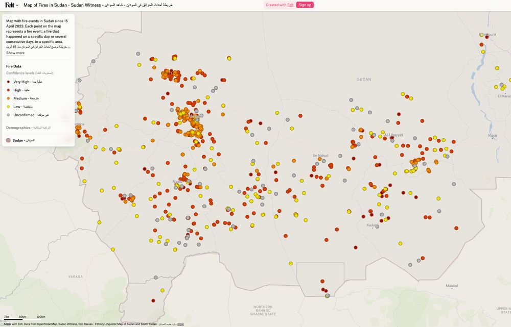
The example of how this looks in practice can be seen on our map of fire events in Sudan, which we have been running since April 2023. felt.com/map/Map-of-F...
October 3, 2025 at 8:13 AM
The example of how this looks in practice can be seen on our map of fire events in Sudan, which we have been running since April 2023. felt.com/map/Map-of-F...
Using a third layer, building footprints, allows the data to be enriched to count how many structures are affected by intersections between the previous data and the building polygons

October 3, 2025 at 8:13 AM
Using a third layer, building footprints, allows the data to be enriched to count how many structures are affected by intersections between the previous data and the building polygons
The extraction of those likely burn areas gives a binary map to allow for a more clear detection of what was not burned vs what is newly burned. This is like turning up the contrast in an image.

October 3, 2025 at 8:13 AM
The extraction of those likely burn areas gives a binary map to allow for a more clear detection of what was not burned vs what is newly burned. This is like turning up the contrast in an image.
The second data source is Sentinel-2 imagery, which validates two images of an event (before and after) to highlight detection of change. In this image for example, we can see the dark spot in the bottom right indicating a burn scar.

October 3, 2025 at 8:13 AM
The second data source is Sentinel-2 imagery, which validates two images of an event (before and after) to highlight detection of change. In this image for example, we can see the dark spot in the bottom right indicating a burn scar.
This tool saves an incredible amount of time in the detection of burned civilian areas.
It uses well-known tools in the industry. The first of which is NASA FIRMS, a tool to detect heat signatures on the earth's surface
It uses well-known tools in the industry. The first of which is NASA FIRMS, a tool to detect heat signatures on the earth's surface

October 3, 2025 at 8:13 AM
This tool saves an incredible amount of time in the detection of burned civilian areas.
It uses well-known tools in the industry. The first of which is NASA FIRMS, a tool to detect heat signatures on the earth's surface
It uses well-known tools in the industry. The first of which is NASA FIRMS, a tool to detect heat signatures on the earth's surface
Our open-source pipeline for detecting war crimes from space is live. Built by our Sudan team at CIR with BigData Republic, it uses NASA FIRMS & Sentinel-2 data to flag burn events near civilian sites, turning satellite imagery into evidence. Full details: bigdatarepublic.nl/articles/det...

October 3, 2025 at 7:56 AM
Our open-source pipeline for detecting war crimes from space is live. Built by our Sudan team at CIR with BigData Republic, it uses NASA FIRMS & Sentinel-2 data to flag burn events near civilian sites, turning satellite imagery into evidence. Full details: bigdatarepublic.nl/articles/det...
Want to see when changes pages are made to a website? There’s a cool function on the @archive.org that lets you track those changes, like where NASA edited out some interesting lines from their site in 2025.
September 30, 2025 at 3:50 PM
Want to see when changes pages are made to a website? There’s a cool function on the @archive.org that lets you track those changes, like where NASA edited out some interesting lines from their site in 2025.
Bing Maps 'birds eye' view has a crazy amount of detail, like this US Navy base - open for the world to see.
www.bing.com/maps/?cp=36....
www.bing.com/maps/?cp=36....
September 23, 2025 at 3:10 PM
Bing Maps 'birds eye' view has a crazy amount of detail, like this US Navy base - open for the world to see.
www.bing.com/maps/?cp=36....
www.bing.com/maps/?cp=36....
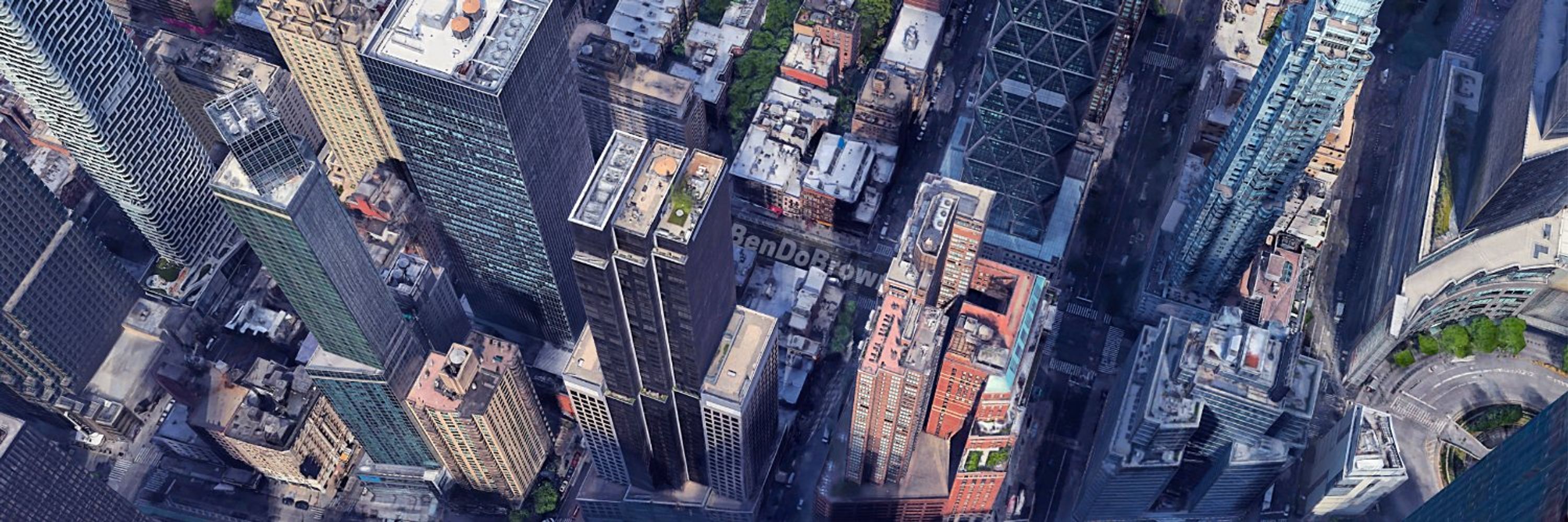
This was an Israeli strike on a residential tower in south Rimal, Gaza City on 10 September, 2025.
It is just one of the 1800+ verified incidents we have mapped across Gaza, West Bank, Lebanon & Israel, which we have updated today: www.info-res.org/israel-gaza-...
It is just one of the 1800+ verified incidents we have mapped across Gaza, West Bank, Lebanon & Israel, which we have updated today: www.info-res.org/israel-gaza-...
September 22, 2025 at 9:29 AM
This was an Israeli strike on a residential tower in south Rimal, Gaza City on 10 September, 2025.
It is just one of the 1800+ verified incidents we have mapped across Gaza, West Bank, Lebanon & Israel, which we have updated today: www.info-res.org/israel-gaza-...
It is just one of the 1800+ verified incidents we have mapped across Gaza, West Bank, Lebanon & Israel, which we have updated today: www.info-res.org/israel-gaza-...
As @ineiversen.bsky.social points out, Russia has rebuilt some areas in Mariupol to stage to stage propaganda.
After bombing this field, they rebuilt it with the Russian Navy flag and slogan "ДОЛГ ЧЕСТЬ ОТВАГА" (Duty, Honour, Courage) - there's no honour here.
bsky.app/profile/inei...
After bombing this field, they rebuilt it with the Russian Navy flag and slogan "ДОЛГ ЧЕСТЬ ОТВАГА" (Duty, Honour, Courage) - there's no honour here.
bsky.app/profile/inei...


September 22, 2025 at 8:52 AM
As @ineiversen.bsky.social points out, Russia has rebuilt some areas in Mariupol to stage to stage propaganda.
After bombing this field, they rebuilt it with the Russian Navy flag and slogan "ДОЛГ ЧЕСТЬ ОТВАГА" (Duty, Honour, Courage) - there's no honour here.
bsky.app/profile/inei...
After bombing this field, they rebuilt it with the Russian Navy flag and slogan "ДОЛГ ЧЕСТЬ ОТВАГА" (Duty, Honour, Courage) - there's no honour here.
bsky.app/profile/inei...
Google Earth has updated imagery of Ukraine's Mariupol - which has been under Russian occupation since May 2022.
This is the Drama Theatre, bombed by Russia in March 2022, where hundreds died. All evidence of the strike has since been wiped away. Location: 47.0960, 37.54871
This is the Drama Theatre, bombed by Russia in March 2022, where hundreds died. All evidence of the strike has since been wiped away. Location: 47.0960, 37.54871
September 22, 2025 at 8:41 AM
Google Earth has updated imagery of Ukraine's Mariupol - which has been under Russian occupation since May 2022.
This is the Drama Theatre, bombed by Russia in March 2022, where hundreds died. All evidence of the strike has since been wiped away. Location: 47.0960, 37.54871
This is the Drama Theatre, bombed by Russia in March 2022, where hundreds died. All evidence of the strike has since been wiped away. Location: 47.0960, 37.54871
Geolocation proof 👇

September 20, 2025 at 3:35 PM
Geolocation proof 👇
Geolocation of footage showing site of reported Israeli drone strike targeting vehicle in Southern Lebanon. Location: 33.32583, 35.54167.
September 20, 2025 at 3:35 PM
Geolocation of footage showing site of reported Israeli drone strike targeting vehicle in Southern Lebanon. Location: 33.32583, 35.54167.
Geolocation of scene from new MI6 recruitment video in Riga - Latvia. Coordinates: 56.949748, 24.104719.
Video: www.youtube.com/watch?v=OYB1...
Video: www.youtube.com/watch?v=OYB1...


September 19, 2025 at 10:02 AM
Geolocation of scene from new MI6 recruitment video in Riga - Latvia. Coordinates: 56.949748, 24.104719.
Video: www.youtube.com/watch?v=OYB1...
Video: www.youtube.com/watch?v=OYB1...
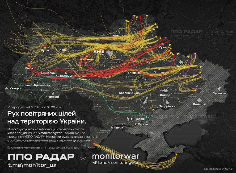
Telegram account 'MonitorWar', which accurately reports on Russian strikes on Ukraine and their paths, has created a visualisation of the massive combined strike on Ukraine that happened overnight. Note the paths that continued into Polish airspace.
Source: t.me/monitoringwa...
Source: t.me/monitoringwa...
September 10, 2025 at 7:21 AM
Telegram account 'MonitorWar', which accurately reports on Russian strikes on Ukraine and their paths, has created a visualisation of the massive combined strike on Ukraine that happened overnight. Note the paths that continued into Polish airspace.
Source: t.me/monitoringwa...
Source: t.me/monitoringwa...
Footage filmed in Indonesia's Jakarta yesterday, during anti-government protests, shows a person hit by an Indonesian police vehicle. The person later died. Today, protests have escalated in his name.
Geolocation of footage: -6.201613, 106.807475
Geolocation of footage: -6.201613, 106.807475
August 29, 2025 at 8:59 AM
Footage filmed in Indonesia's Jakarta yesterday, during anti-government protests, shows a person hit by an Indonesian police vehicle. The person later died. Today, protests have escalated in his name.
Geolocation of footage: -6.201613, 106.807475
Geolocation of footage: -6.201613, 106.807475
From Danish broadcaster dr.dk (dr.dk/nyheder/indl...)

August 27, 2025 at 10:15 AM
From Danish broadcaster dr.dk (dr.dk/nyheder/indl...)
Our map on incidents in Gaza, West Bank, Lebanon and Israel has been updated to show incidents up until last week. A number of these include events where our team at @cen4infores.bsky.social has visually identified many casualties.
View the map here: www.info-res.org/israel-gaza-...
View the map here: www.info-res.org/israel-gaza-...
August 7, 2025 at 11:07 AM
Our map on incidents in Gaza, West Bank, Lebanon and Israel has been updated to show incidents up until last week. A number of these include events where our team at @cen4infores.bsky.social has visually identified many casualties.
View the map here: www.info-res.org/israel-gaza-...
View the map here: www.info-res.org/israel-gaza-...
Geolocation of image six, showing the large levels of destruction across Jabalia. Location: 31.545160, 34.47160


August 7, 2025 at 10:14 AM
Geolocation of image six, showing the large levels of destruction across Jabalia. Location: 31.545160, 34.47160
Geolocation of fifth image, showing Jordanian air force air lift over Gaza city. Location: 31.49023, 34.41437.


August 7, 2025 at 10:14 AM
Geolocation of fifth image, showing Jordanian air force air lift over Gaza city. Location: 31.49023, 34.41437.