


Billy Armstrong
@app-glaciers.bsky.social
App State associate professor interested in glacier processes, glacier change, and downstream impacts
I'm teaching a scientific writing course and figuring out how to talk about effective use of AI writing tools. I was interested to see ChatGPT's response about its weaknesses. Do other people have effective activities for talking about ethical LLM use with undergraduates?
chatgpt.com/share/68a620...
chatgpt.com/share/68a620...

August 20, 2025 at 7:34 PM
I'm teaching a scientific writing course and figuring out how to talk about effective use of AI writing tools. I was interested to see ChatGPT's response about its weaknesses. Do other people have effective activities for talking about ethical LLM use with undergraduates?
chatgpt.com/share/68a620...
chatgpt.com/share/68a620...
@watershedlab.bsky.social Super turbid! Jocelyn Reahl at @instaar.bsky.social collected water samples at various depths and is going to be working the sediments angle. It will be cool to see if/how sediments significantly alter glacier behavior here!

July 29, 2025 at 3:49 PM
@watershedlab.bsky.social Super turbid! Jocelyn Reahl at @instaar.bsky.social collected water samples at various depths and is going to be working the sediments angle. It will be cool to see if/how sediments significantly alter glacier behavior here!
This work is funded by NSF and in collaboration with @terrawonderer.bsky.social and Dave Sutherland. I couldn’t ask for a better team!

July 29, 2025 at 3:20 PM
This work is funded by NSF and in collaboration with @terrawonderer.bsky.social and Dave Sutherland. I couldn’t ask for a better team!
We will combine these datasets with stationary moorings, on glacier GPS, and sediment traps to assess how much ice is being lost through subaqueous melt and iceberg calving at Gilkey Glacier. We will also assess how much this matters for the glacier’s past and future evolution.

July 29, 2025 at 3:17 PM
We will combine these datasets with stationary moorings, on glacier GPS, and sediment traps to assess how much ice is being lost through subaqueous melt and iceberg calving at Gilkey Glacier. We will also assess how much this matters for the glacier’s past and future evolution.
We used radio echo sounding to measure ice thickness. These data, in combination with terminus multibeam scans, show that the glacier tongue is not floating at present, though remote sensing data suggest this has varied in the past.

July 29, 2025 at 3:12 PM
We used radio echo sounding to measure ice thickness. These data, in combination with terminus multibeam scans, show that the glacier tongue is not floating at present, though remote sensing data suggest this has varied in the past.
We used a multibeam sonar to measure lake bathymetry and conduct repeat terminus scans. We found maximum lake depth of 200 m with a relatively flat floor, suggesting significant sediment infilling post retreat

July 29, 2025 at 3:07 PM
We used a multibeam sonar to measure lake bathymetry and conduct repeat terminus scans. We found maximum lake depth of 200 m with a relatively flat floor, suggesting significant sediment infilling post retreat
Just got back from a week of work on the lake-terminating Gilkey Glacier near Juneau #Alaska. A quick summary of data collected and some initial results:

July 29, 2025 at 3:04 PM
Just got back from a week of work on the lake-terminating Gilkey Glacier near Juneau #Alaska. A quick summary of data collected and some initial results:
We find that #Alaska lake-terminating glaciers lose ~5x less mass through the terminus than an Alaska marine-terminating glacier and ~3x less than a #Patagonia lake-terminating glacier. Warming or deepening of proglacial lakes could push the region's glaciers toward higher rates of mass loss

May 23, 2025 at 2:34 PM
We find that #Alaska lake-terminating glaciers lose ~5x less mass through the terminus than an Alaska marine-terminating glacier and ~3x less than a #Patagonia lake-terminating glacier. Warming or deepening of proglacial lakes could push the region's glaciers toward higher rates of mass loss
We estimate the average Alaska lake-terminating glacier has 9 km of lake expansion potential and will remain in contact with its proglacial lake for the next 74 years. This makes process understanding of glacier-lake interactions important for projecting glacier response to #climatechange

May 23, 2025 at 2:31 PM
We estimate the average Alaska lake-terminating glacier has 9 km of lake expansion potential and will remain in contact with its proglacial lake for the next 74 years. This makes process understanding of glacier-lake interactions important for projecting glacier response to #climatechange
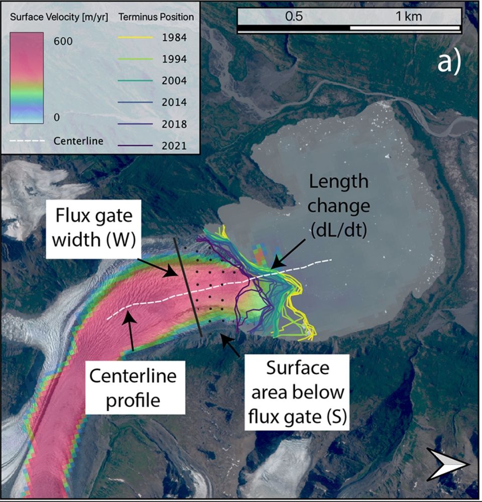
On average, the region's lake-terminating #glaciers retreated by 60 m/yr over 1984-2021. The glaciers lost 0.04 Gt/yr of ice through iceberg calving and subaqueous melt over 2009-2018, equivalent to 25 cm w.e./yr surface lowering if spread evenly across the glacier surface

May 23, 2025 at 2:25 PM
On average, the region's lake-terminating #glaciers retreated by 60 m/yr over 1984-2021. The glaciers lost 0.04 Gt/yr of ice through iceberg calving and subaqueous melt over 2009-2018, equivalent to 25 cm w.e./yr surface lowering if spread evenly across the glacier surface
Excited that Noah Caldwell's work is officially out in @igsoc.bsky.social Journal of Glaciology! Noah used satellite remote sensing to estimate how much ice is being lost to iceberg calving and subaqueous melt on 55 Alaska lake-terminating glaciers. Read more: doi.org/10.1017/jog....
May 23, 2025 at 2:18 PM
Excited that Noah Caldwell's work is officially out in @igsoc.bsky.social Journal of Glaciology! Noah used satellite remote sensing to estimate how much ice is being lost to iceberg calving and subaqueous melt on 55 Alaska lake-terminating glaciers. Read more: doi.org/10.1017/jog....
Declining suspended sediment was the predominant trend for glacier-fed rivers with upstream lakes, while trends were more mixed for rivers without upstream lakes.

February 18, 2025 at 12:48 PM
Declining suspended sediment was the predominant trend for glacier-fed rivers with upstream lakes, while trends were more mixed for rivers without upstream lakes.
Glacier-fed rivers without an upstream lake had the highest suspended sediment concentration (SSC). Rivers with well-developed upstream lakes had the lowest SSC, showing these lakes are acting as efficient sediment traps. Rivers with newly-formed lakes upstream had widely varying SSC.

February 18, 2025 at 11:16 AM
Glacier-fed rivers without an upstream lake had the highest suspended sediment concentration (SSC). Rivers with well-developed upstream lakes had the lowest SSC, showing these lakes are acting as efficient sediment traps. Rivers with newly-formed lakes upstream had widely varying SSC.
Very proud to see Lily Vowels' senior thesis work published in #Geomorphology! Lily used #Landsat imagery to investigate how suspended sediment in #Alaska glacier-fed rivers has changed over the last ~40 years as #glaciers have retreated and terminal #lakes have formed and grown 🧪

February 18, 2025 at 11:12 AM
Very proud to see Lily Vowels' senior thesis work published in #Geomorphology! Lily used #Landsat imagery to investigate how suspended sediment in #Alaska glacier-fed rivers has changed over the last ~40 years as #glaciers have retreated and terminal #lakes have formed and grown 🧪
We use handheld ones for doing point sampling in class that are more on the order of $250 made by hanna instruments

January 26, 2025 at 1:24 AM
We use handheld ones for doing point sampling in class that are more on the order of $250 made by hanna instruments
The jumps are several times the L1/L2 wavelength, which is 19-25 cm. I would have expected this length scale to pop up if it were integer ambiguity, but maybe it’s not so simple?

January 24, 2025 at 1:09 AM
The jumps are several times the L1/L2 wavelength, which is 19-25 cm. I would have expected this length scale to pop up if it were integer ambiguity, but maybe it’s not so simple?
This is a great idea - I’ll look into it. It seems like NRCan is finding 3 possible solutions for antenna positions that differ by an identical amount at all sites (separated by several km). I could see this being something where it’s jumping to a previous guess.
January 23, 2025 at 7:22 PM
This is a great idea - I’ll look into it. It seems like NRCan is finding 3 possible solutions for antenna positions that differ by an identical amount at all sites (separated by several km). I could see this being something where it’s jumping to a previous guess.
Thanks for this idea - I will check into it, but don’t think it’s likely as we’ve used the same receivers/antennas at almost the exact same place, and there is no time-of-day pattern to the position jumping - it’s constant. See my reply to Julie for more context here
January 23, 2025 at 7:20 PM
Thanks for this idea - I will check into it, but don’t think it’s likely as we’ve used the same receivers/antennas at almost the exact same place, and there is no time-of-day pattern to the position jumping - it’s constant. See my reply to Julie for more context here
I dug into this and feel even more lost - the position jumping is happening ~constantly. There is no pattern to time of day, but 5 stations are jumping by the ~exact same amount in all 3 coordinates - it’s like there’s 3 possible solutions for their positions?
January 23, 2025 at 7:17 PM
I dug into this and feel even more lost - the position jumping is happening ~constantly. There is no pattern to time of day, but 5 stations are jumping by the ~exact same amount in all 3 coordinates - it’s like there’s 3 possible solutions for their positions?
I first thought there were duplicate positions, but zooming in you can see that’s not what’s going on (plots are time series of easting, nothing, vertical antenna position over several months in 2023).

January 22, 2025 at 2:14 AM
I first thought there were duplicate positions, but zooming in you can see that’s not what’s going on (plots are time series of easting, nothing, vertical antenna position over several months in 2023).
GPS enthusiasts - has anyone ever seen behavior where a station non-physically jumps positions back & forth between epochs? The jumps are 10-100 cm in scale, the data were processed via NRCan PPP, it’s a Trimble NetRS receiver sampling every 15 s installed on a glacier in the Canadian Rockies

January 22, 2025 at 2:09 AM
GPS enthusiasts - has anyone ever seen behavior where a station non-physically jumps positions back & forth between epochs? The jumps are 10-100 cm in scale, the data were processed via NRCan PPP, it’s a Trimble NetRS receiver sampling every 15 s installed on a glacier in the Canadian Rockies