


Amber Wheeler
@amberwheeler.bsky.social
FOX 8 Nola Meteorologist. Probably talking about my dog right now. Ship traffic watcher. Sriracha enthusiast. People say I’m nice.
For the first time in nearly 10 years, there are no active tropical systems to track on the peak day of hurricane season. #tropics #hurricaneseason

September 10, 2025 at 4:45 PM
For the first time in nearly 10 years, there are no active tropical systems to track on the peak day of hurricane season. #tropics #hurricaneseason
This is my little monster. Tina is 14 now. FOURTEEN. They grow up so fast, don’t they? 🐕❤️

September 5, 2025 at 6:07 PM
This is my little monster. Tina is 14 now. FOURTEEN. They grow up so fast, don’t they? 🐕❤️
From a tropical storm to a major Cat 4 hurricane in less than 24 hours. Erin has exceeded expectations and is continuing to rapidly intensify. It had 70 mph yesterday morning. It’s more than doubled at 145 mph. Bermuda is now in the cone. No other direct impacts to land are expected. #erin

August 16, 2025 at 12:37 PM
From a tropical storm to a major Cat 4 hurricane in less than 24 hours. Erin has exceeded expectations and is continuing to rapidly intensify. It had 70 mph yesterday morning. It’s more than doubled at 145 mph. Bermuda is now in the cone. No other direct impacts to land are expected. #erin
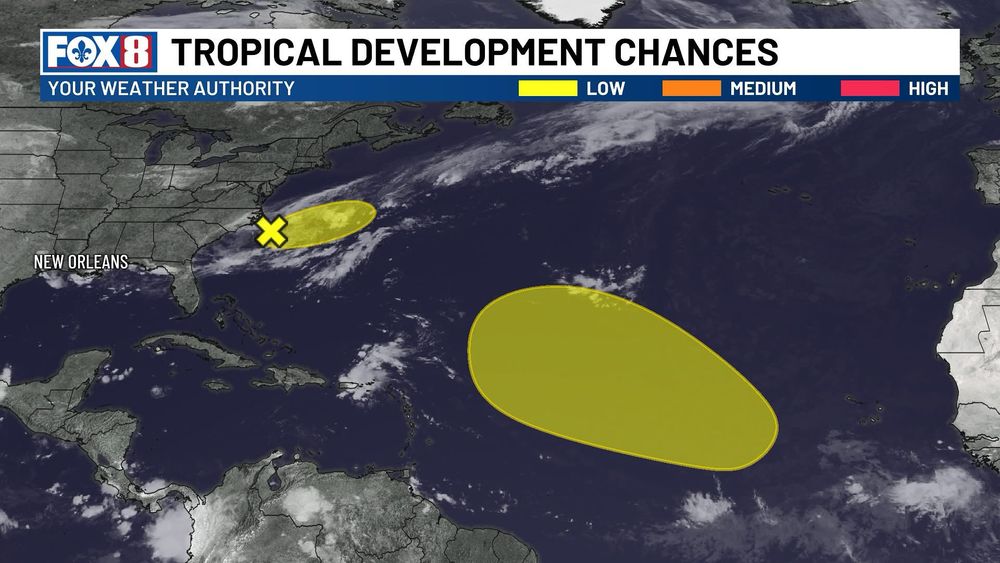
Two areas to watch.The first is located just off the East Coast, where a frontal may help organize low-pressure. It's expected to move away from land. The 2nd area is farther east in the Atlantic. A tropical wave is expected to enter favorable conditions for development by mid to late next week.
August 3, 2025 at 12:24 AM
Two areas to watch.The first is located just off the East Coast, where a frontal may help organize low-pressure. It's expected to move away from land. The 2nd area is farther east in the Atlantic. A tropical wave is expected to enter favorable conditions for development by mid to late next week.
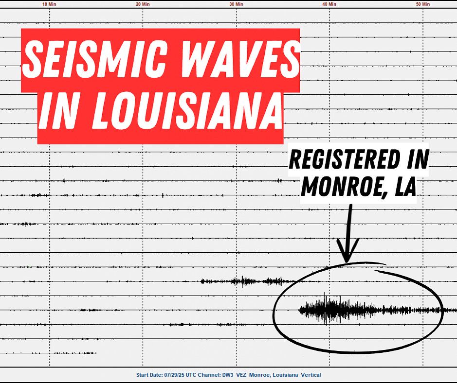
The powerful earthquake near Russia was so strong, it sent seismic waves all the way to Louisiana (and across the rest of the globe)… in just about 15 minutes. While we didn’t feel them, sensitive instruments picked up the motion. Data courtesy of Bayou State Weather. #lawx #earthquake
July 30, 2025 at 2:20 PM
The powerful earthquake near Russia was so strong, it sent seismic waves all the way to Louisiana (and across the rest of the globe)… in just about 15 minutes. While we didn’t feel them, sensitive instruments picked up the motion. Data courtesy of Bayou State Weather. #lawx #earthquake
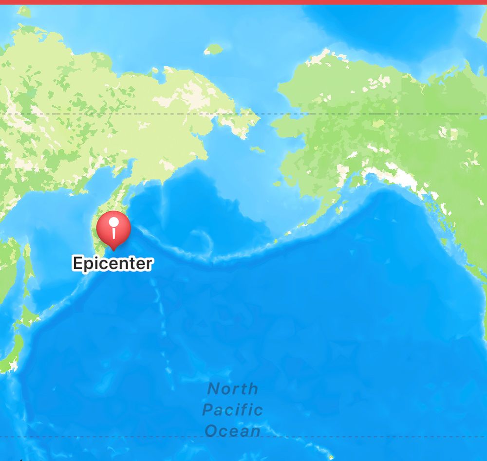
A massive 8.0 magnitude earthquake just struck off the Kamchatka Peninsula in Russia. Tsunami threat to Japan and Russia. Tsunami Advisory for the Aleutian Islands and a Tsunami Watch for Hawaii and Guam. #earthquake #tsunami
July 30, 2025 at 12:14 AM
A massive 8.0 magnitude earthquake just struck off the Kamchatka Peninsula in Russia. Tsunami threat to Japan and Russia. Tsunami Advisory for the Aleutian Islands and a Tsunami Watch for Hawaii and Guam. #earthquake #tsunami
A tropical wave will move into the Atlantic. It’s packing plenty of moisture, which gives it some potential, but it still faces challenges like Saharan dust and the occasional hostile upper-level winds. Nothing is unusual about this. It's typical late July/early August.
July 27, 2025 at 9:10 PM
A tropical wave will move into the Atlantic. It’s packing plenty of moisture, which gives it some potential, but it still faces challenges like Saharan dust and the occasional hostile upper-level winds. Nothing is unusual about this. It's typical late July/early August.

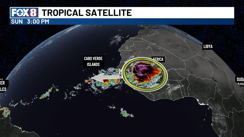
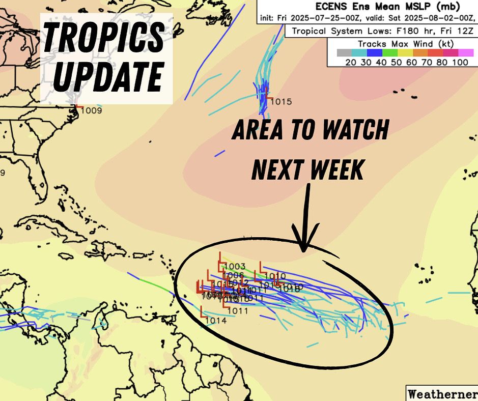
August marks the start of the typical uptick in Atlantic tropical activity, and models are taking notice. The reliable European ensemble is hinting at a strong tropical wave emerging off Africa that bears watching. #tropics
July 25, 2025 at 7:57 PM
August marks the start of the typical uptick in Atlantic tropical activity, and models are taking notice. The reliable European ensemble is hinting at a strong tropical wave emerging off Africa that bears watching. #tropics
Six months ago today I was standing on an I-10 overpass during a snowstorm in New Orleans. You should be able to see the Superdome in this photo, but the heavy snow makes it impossible. I took this photo for my way later years to look back on and remember covering this historic event. #nola

July 21, 2025 at 4:39 PM
Six months ago today I was standing on an I-10 overpass during a snowstorm in New Orleans. You should be able to see the Superdome in this photo, but the heavy snow makes it impossible. I took this photo for my way later years to look back on and remember covering this historic event. #nola
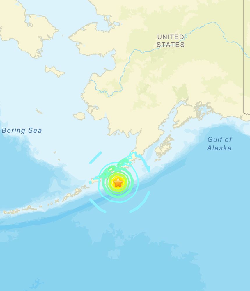
A TSUNAMI WARNING has been issued for portions of Alaska following a M7.2 earthquake registered 50 miles S of Sand Point, Alaska. Residents are urged to move farther inland. #earthquake
July 16, 2025 at 9:42 PM
A TSUNAMI WARNING has been issued for portions of Alaska following a M7.2 earthquake registered 50 miles S of Sand Point, Alaska. Residents are urged to move farther inland. #earthquake
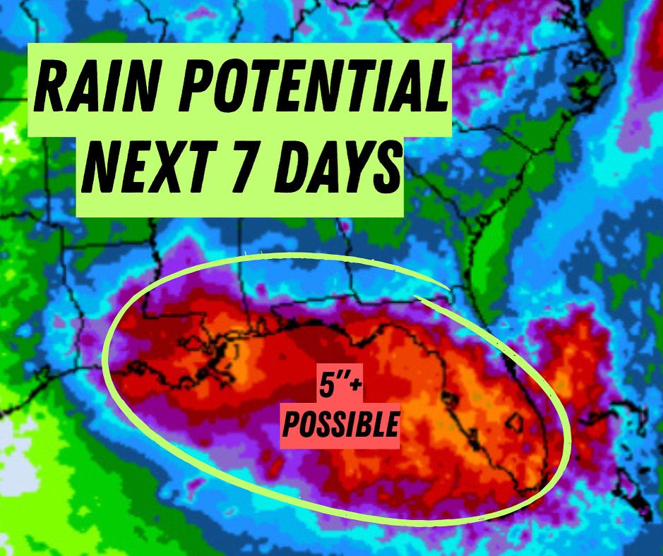
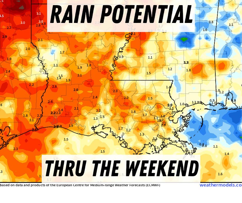
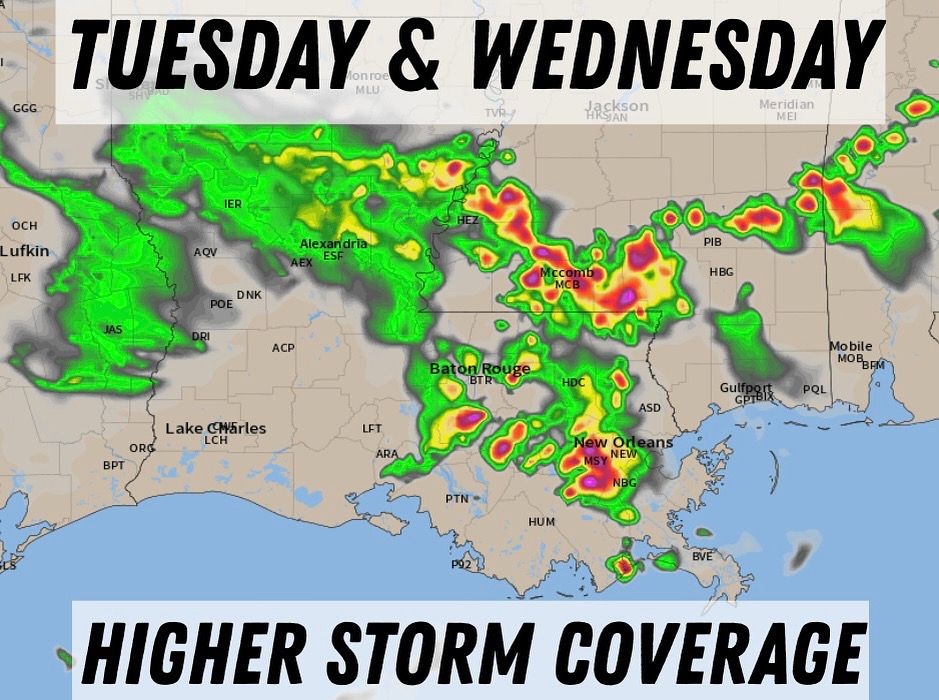
Tropical moisture will bring a flood threat to the Gulf Coast this week. Here in LA, we’re looking at the potential for a multi-day flood threat starting late Wed. Could this system develop into a tropical depression or storm? Yes, but if it does, it would be weak. The bigger concern is the rain.
July 14, 2025 at 3:06 PM
Tropical moisture will bring a flood threat to the Gulf Coast this week. Here in LA, we’re looking at the potential for a multi-day flood threat starting late Wed. Could this system develop into a tropical depression or storm? Yes, but if it does, it would be weak. The bigger concern is the rain.
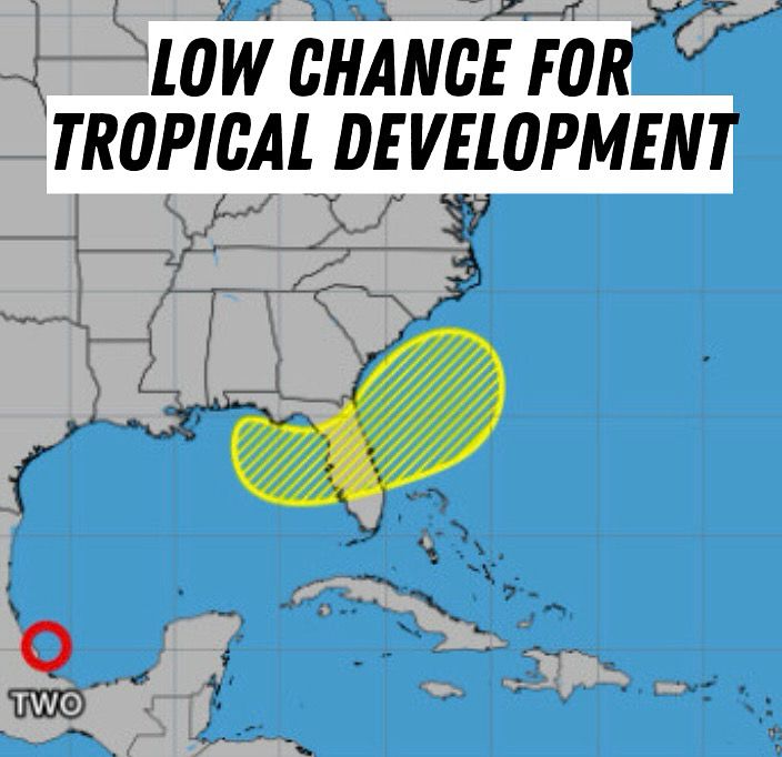
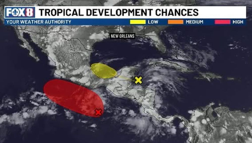
The NHC has highlighted an area in the eastern Gulf and off the SE coast. Slow development is possible this week. If it doesn’t develop, it’ll certainly dump a ton of rain. #tropics
June 29, 2025 at 2:37 PM
The NHC has highlighted an area in the eastern Gulf and off the SE coast. Slow development is possible this week. If it doesn’t develop, it’ll certainly dump a ton of rain. #tropics
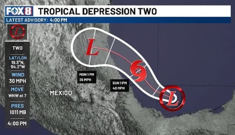
A tropical storm is expected to form by Sunday in the southern Gulf. It would take the name Barry. The storm is projected to make landfall early Monday morning in eastern Mexico
June 28, 2025 at 9:37 PM
A tropical storm is expected to form by Sunday in the southern Gulf. It would take the name Barry. The storm is projected to make landfall early Monday morning in eastern Mexico
Invest 91L is showing signs of organizing. A Hurricane Hunter is currently flying through the storm. This could be organized into a depression by this afternoon. If that's the case, Tropical Storm watches and warnings may be issued soon for the Mexican Gulf coast. #tropics
June 28, 2025 at 6:51 PM
Invest 91L is showing signs of organizing. A Hurricane Hunter is currently flying through the storm. This could be organized into a depression by this afternoon. If that's the case, Tropical Storm watches and warnings may be issued soon for the Mexican Gulf coast. #tropics
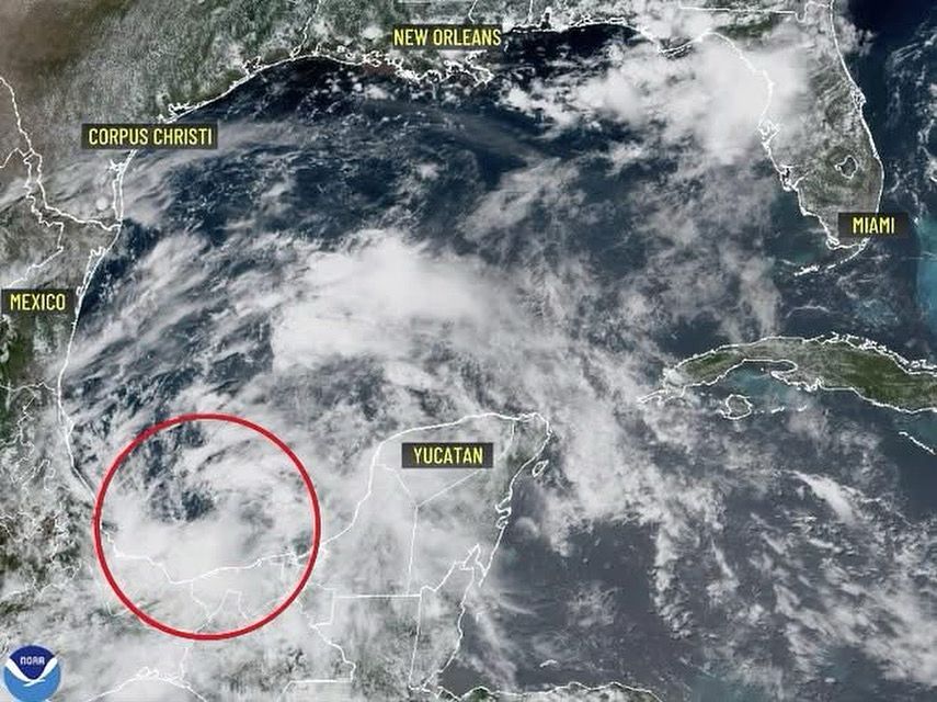
GULF STORM? Hurricane Hunters will fly into this storm Saturday. It's now called Invest 91L, which means it has not developed but is being investigated further. A tropical depression is possible this weekend. Any development is expected to move into eastern Mexico and will bring torrential rain.

June 28, 2025 at 1:19 AM
GULF STORM? Hurricane Hunters will fly into this storm Saturday. It's now called Invest 91L, which means it has not developed but is being investigated further. A tropical depression is possible this weekend. Any development is expected to move into eastern Mexico and will bring torrential rain.
There's a new area of interest in the Atlantic. This time in the Bay of Campeche. Conditions aren’t especially favorable right now. Cooler-than-normal water temperatures in that region will make it difficult for development to occur. Development is much more favorable on the Pacific side. #tropics
June 27, 2025 at 1:20 AM
There's a new area of interest in the Atlantic. This time in the Bay of Campeche. Conditions aren’t especially favorable right now. Cooler-than-normal water temperatures in that region will make it difficult for development to occur. Development is much more favorable on the Pacific side. #tropics
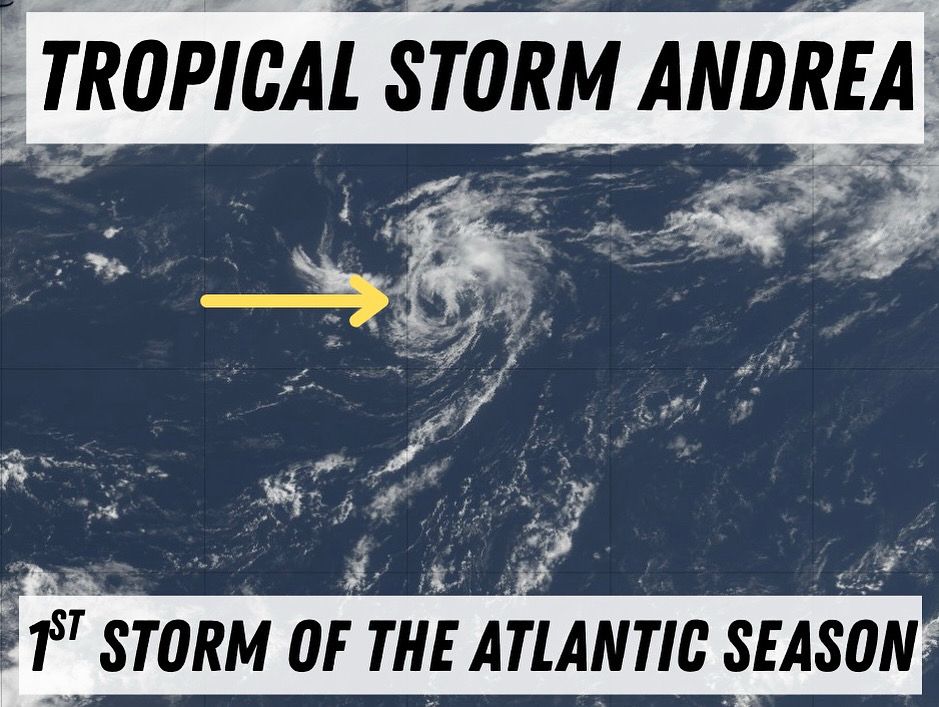
The first storm of the 2025 Atlantic hurricane season has formed. It”s located in the middle of the Atlantic and will be short lived, posing no threat to land. #tropics
June 24, 2025 at 2:18 PM
The first storm of the 2025 Atlantic hurricane season has formed. It”s located in the middle of the Atlantic and will be short lived, posing no threat to land. #tropics
From Canada to Cocodrie, LA. You can see the haze from wildfire smoke brought in by the upper level winds. It makes the sun look muted. #lawx #wildfiresmoke
📸 Tom and Sharon McClain
📸 Tom and Sharon McClain
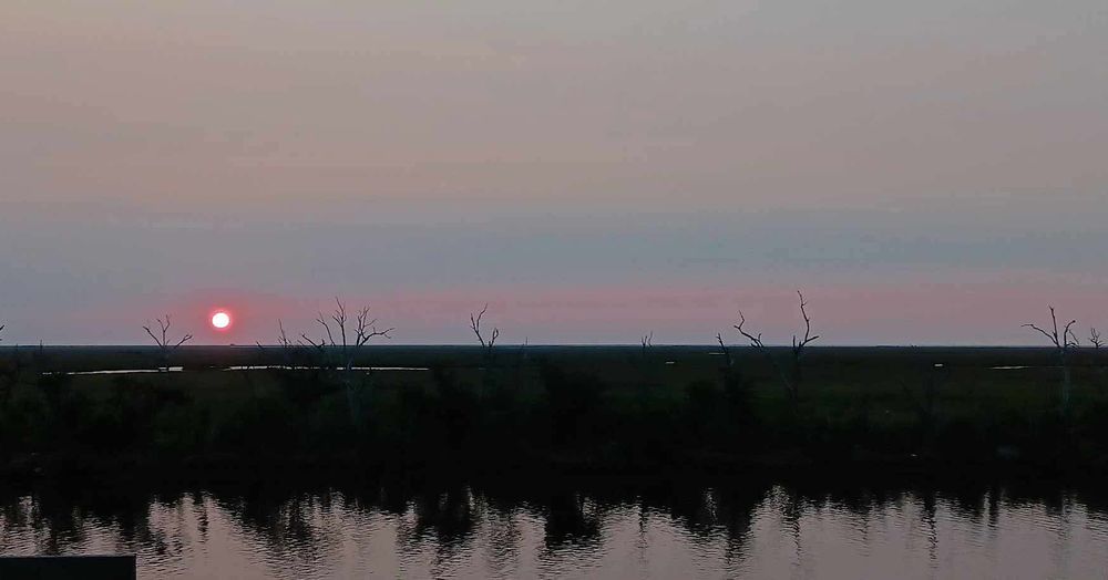
June 3, 2025 at 3:35 PM
From Canada to Cocodrie, LA. You can see the haze from wildfire smoke brought in by the upper level winds. It makes the sun look muted. #lawx #wildfiresmoke
📸 Tom and Sharon McClain
📸 Tom and Sharon McClain
Wildfire smoke is clearly visible on sat imagery this afternoon, stretching all the way from North Dakota down to Georgia. While the smoke won't impact air quality in the South, it’s a different story in the Upper Plains. ND, in particular, is experiencing very unhealthy air quality today.
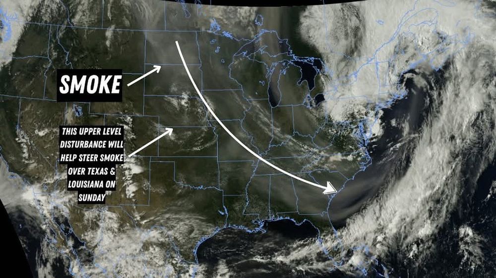
May 31, 2025 at 9:57 PM
Wildfire smoke is clearly visible on sat imagery this afternoon, stretching all the way from North Dakota down to Georgia. While the smoke won't impact air quality in the South, it’s a different story in the Upper Plains. ND, in particular, is experiencing very unhealthy air quality today.