


Alan McConchie
@alan.subdued.social.ap.brid.gy
Admin of subdued.social in #BellinghamWA. Lead Cartographer at https://vis.social/@stamen. Social media for https://social.ridetrans.it/@CascadiaRail. 15 minutes […]
[bridged from https://subdued.social/@alan on the fediverse by https://fed.brid.gy/ ]
[bridged from https://subdued.social/@alan on the fediverse by https://fed.brid.gy/ ]
Loving the new "Constellation Map" view on Native Land Digital:
https://native-land.ca/maps/constellation
#nativeland #indigenousmapping #nativelanddigital
https://native-land.ca/maps/constellation
#nativeland #indigenousmapping #nativelanddigital

December 15, 2025 at 11:15 PM
Loving the new "Constellation Map" view on Native Land Digital:
https://native-land.ca/maps/constellation
#nativeland #indigenousmapping #nativelanddigital
https://native-land.ca/maps/constellation
#nativeland #indigenousmapping #nativelanddigital
https://www.theguardian.com/us-news/2025/nov/30/alabama-teenager-election-map-voting-rights
"The decision stunned “DD” – an 18-year-old freshman at the University of Alabama named Daniel DiDonato – who learned his map had been selected as he was preparing to leave for his 9.30am introduction to […]
"The decision stunned “DD” – an 18-year-old freshman at the University of Alabama named Daniel DiDonato – who learned his map had been selected as he was preparing to leave for his 9.30am introduction to […]
Original post on subdued.social
subdued.social
December 1, 2025 at 4:58 PM
https://www.theguardian.com/us-news/2025/nov/30/alabama-teenager-election-map-voting-rights
"The decision stunned “DD” – an 18-year-old freshman at the University of Alabama named Daniel DiDonato – who learned his map had been selected as he was preparing to leave for his 9.30am introduction to […]
"The decision stunned “DD” – an 18-year-old freshman at the University of Alabama named Daniel DiDonato – who learned his map had been selected as he was preparing to leave for his 9.30am introduction to […]
Reposting some #30daymapchallenge maps from local cartographer and geography professor Aquila Flower (who isn't on Mastodon). Sharing for the local #pnw and #bellinghamwa content!
1. The age of buildings in Bellingham, WA
2. Density of marine passenger […]
[Original post on subdued.social]
1. The age of buildings in Bellingham, WA
2. Density of marine passenger […]
[Original post on subdued.social]


November 14, 2025 at 5:57 PM
Reposting some #30daymapchallenge maps from local cartographer and geography professor Aquila Flower (who isn't on Mastodon). Sharing for the local #pnw and #bellinghamwa content!
1. The age of buildings in Bellingham, WA
2. Density of marine passenger […]
[Original post on subdued.social]
1. The age of buildings in Bellingham, WA
2. Density of marine passenger […]
[Original post on subdued.social]
Recent poll shows good support for #proportionalrepresentation:
"48% of adults say they would support a system where states are required to assign seats in the U.S. House in proportion to the number of votes won statewide, while 19% are opposed. 32% of respondents said 'don’t know'" […]
"48% of adults say they would support a system where states are required to assign seats in the U.S. House in proportion to the number of votes won statewide, while 19% are opposed. 32% of respondents said 'don’t know'" […]
Original post on subdued.social
subdued.social
November 7, 2025 at 6:13 AM
Recent poll shows good support for #proportionalrepresentation:
"48% of adults say they would support a system where states are required to assign seats in the U.S. House in proportion to the number of votes won statewide, while 19% are opposed. 32% of respondents said 'don’t know'" […]
"48% of adults say they would support a system where states are required to assign seats in the U.S. House in proportion to the number of votes won statewide, while 19% are opposed. 32% of respondents said 'don’t know'" […]
From the interview with #gerrymandering researcher Moon Duchin in the NYTimes: https://www.nytimes.com/2025/11/03/science/duchin-math-elections-gerrymandering.html
Duchin: "I think taking a hard look at the design of electoral systems could get us out of this nuclear moment."
NYT: What are the […]
Duchin: "I think taking a hard look at the design of electoral systems could get us out of this nuclear moment."
NYT: What are the […]
Original post on subdued.social
subdued.social
November 3, 2025 at 6:10 PM
From the interview with #gerrymandering researcher Moon Duchin in the NYTimes: https://www.nytimes.com/2025/11/03/science/duchin-math-elections-gerrymandering.html
Duchin: "I think taking a hard look at the design of electoral systems could get us out of this nuclear moment."
NYT: What are the […]
Duchin: "I think taking a hard look at the design of electoral systems could get us out of this nuclear moment."
NYT: What are the […]
I'm seeing a lot of reports of mailbox break-ins in #bellinghamwa (hard to tell if it's any more than usual).
A reminder to everybody to check your ballot status at votewa.gov frequently during election season! You can see when it was mailed to you, & when they received it (or not) after you've […]
A reminder to everybody to check your ballot status at votewa.gov frequently during election season! You can see when it was mailed to you, & when they received it (or not) after you've […]
Original post on subdued.social
subdued.social
October 23, 2025 at 5:13 PM
I'm seeing a lot of reports of mailbox break-ins in #bellinghamwa (hard to tell if it's any more than usual).
A reminder to everybody to check your ballot status at votewa.gov frequently during election season! You can see when it was mailed to you, & when they received it (or not) after you've […]
A reminder to everybody to check your ballot status at votewa.gov frequently during election season! You can see when it was mailed to you, & when they received it (or not) after you've […]
Beautiful map of precipitation and tree canopy height around the #salishsea, by Dave Taylor of Pathfinder Geospatial:
https://www.maps.com/the-soaked-canopies-near-the-salish-sea/
#maps #cartography #pnw #cascadia
https://www.maps.com/the-soaked-canopies-near-the-salish-sea/
#maps #cartography #pnw #cascadia

The Soaked Canopies Near the Salish Sea
The Pacific Northwest is known for its cool, wet climate. But this is no drab and dreary landscape.
www.maps.com
October 22, 2025 at 10:07 PM
Beautiful map of precipitation and tree canopy height around the #salishsea, by Dave Taylor of Pathfinder Geospatial:
https://www.maps.com/the-soaked-canopies-near-the-salish-sea/
#maps #cartography #pnw #cascadia
https://www.maps.com/the-soaked-canopies-near-the-salish-sea/
#maps #cartography #pnw #cascadia
I love that two amazing map-makers won MacArthur Foundation genius grants this year: Tonika Lewis Johnson, and Margaret Wickens Pearce.
Pearce's work in particular I've been following for years, and according to Wikipedia she is the first awardee in history […]
[Original post on subdued.social]
Pearce's work in particular I've been following for years, and according to Wikipedia she is the first awardee in history […]
[Original post on subdued.social]


October 10, 2025 at 1:09 AM
I love that two amazing map-makers won MacArthur Foundation genius grants this year: Tonika Lewis Johnson, and Margaret Wickens Pearce.
Pearce's work in particular I've been following for years, and according to Wikipedia she is the first awardee in history […]
[Original post on subdued.social]
Pearce's work in particular I've been following for years, and according to Wikipedia she is the first awardee in history […]
[Original post on subdued.social]
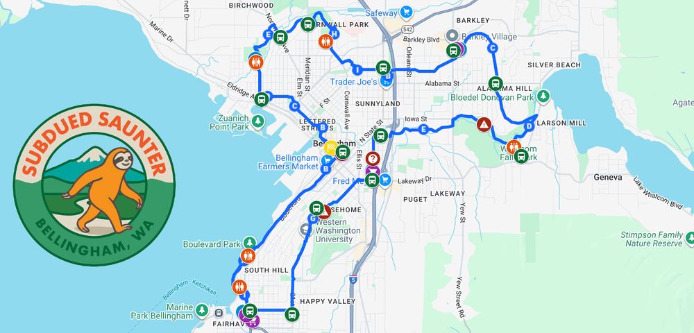
This looks awesome:
"Join us for the first ever Bellingham Subdued Saunter! A self-paced nearly 20 mile walk exploring Bellingham with Walk & Roll and Holden Ringer, founder of the Seattle Super Saunter. We're excited to bring together locals and visitors to […]
[Original post on subdued.social]
"Join us for the first ever Bellingham Subdued Saunter! A self-paced nearly 20 mile walk exploring Bellingham with Walk & Roll and Holden Ringer, founder of the Seattle Super Saunter. We're excited to bring together locals and visitors to […]
[Original post on subdued.social]
September 23, 2025 at 6:16 PM
This looks awesome:
"Join us for the first ever Bellingham Subdued Saunter! A self-paced nearly 20 mile walk exploring Bellingham with Walk & Roll and Holden Ringer, founder of the Seattle Super Saunter. We're excited to bring together locals and visitors to […]
[Original post on subdued.social]
"Join us for the first ever Bellingham Subdued Saunter! A self-paced nearly 20 mile walk exploring Bellingham with Walk & Roll and Holden Ringer, founder of the Seattle Super Saunter. We're excited to bring together locals and visitors to […]
[Original post on subdued.social]
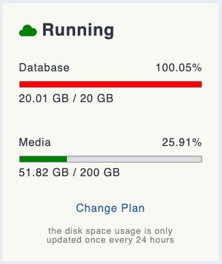
Admin announcement for #subduedsocial users:
Our database usage is now past 20GB so we need to upgrade from the $39/mo plan to the $89/mo plan on @mastohost, or we start deleting old remote content (with the downside that we will lose old bookmarked toots and […]
[Original post on subdued.social]
Our database usage is now past 20GB so we need to upgrade from the $39/mo plan to the $89/mo plan on @mastohost, or we start deleting old remote content (with the downside that we will lose old bookmarked toots and […]
[Original post on subdued.social]
September 19, 2025 at 6:17 PM
Admin announcement for #subduedsocial users:
Our database usage is now past 20GB so we need to upgrade from the $39/mo plan to the $89/mo plan on @mastohost, or we start deleting old remote content (with the downside that we will lose old bookmarked toots and […]
[Original post on subdued.social]
Our database usage is now past 20GB so we need to upgrade from the $39/mo plan to the $89/mo plan on @mastohost, or we start deleting old remote content (with the downside that we will lose old bookmarked toots and […]
[Original post on subdued.social]
Commentary from 25 county auditors in #washingtonstate: "Vote-at-home is the law in Washington — and it works"
https://washingtonstatestandard.com/2025/09/16/vote-at-home-is-the-law-in-washington-and-it-works/
#elections #votebymail #uspol #uspolitics
https://washingtonstatestandard.com/2025/09/16/vote-at-home-is-the-law-in-washington-and-it-works/
#elections #votebymail #uspol #uspolitics
September 17, 2025 at 4:22 PM
Commentary from 25 county auditors in #washingtonstate: "Vote-at-home is the law in Washington — and it works"
https://washingtonstatestandard.com/2025/09/16/vote-at-home-is-the-law-in-washington-and-it-works/
#elections #votebymail #uspol #uspolitics
https://washingtonstatestandard.com/2025/09/16/vote-at-home-is-the-law-in-washington-and-it-works/
#elections #votebymail #uspol #uspolitics
Happy #nationalvoterregistrationday to those who celebrate!
https://nationalvoterregistrationday.org/register-to-vote/
#voting #elections #voterregistration #voteready #uspol #uspolitics
https://nationalvoterregistrationday.org/register-to-vote/
#voting #elections #voterregistration #voteready #uspol #uspolitics

Register to Vote/Check Registration
If you’re looking to register to vote or check/update your voter registration, you’re in the right place! Not sure if you need to update your registration? Here’s a list of reasons to check your status:
* You’ve moved
* You’ve changed your name since you last voted
* You got married
Here you can quickly and easily get registered to vote. Simply select your state from the dropdown menu below and you will automatically be redirected to a menu of official voter registration tools for your state on Vote.gov.
Select a State Alabama Alaska Arizona Arkansas California Colorado Connecticut Delaware District of Columbia Florida Georgia Guam Hawaii Idaho Illinois Indiana Iowa Kansas Kentucky Louisiana Maine Maryland Massachusetts Michigan Minnesota Mississippi Missouri Montana Nebraska Nevada New Hampshire New Jersey New Mexico New York North Carolina North Dakota Ohio Oklahoma Oregon Pennsylvania Rhode Island South Carolina South Dakota Tennessee Texas Utah Vermont Virginia Washington West Virginia Wisconsin Wyoming
_**Note:** If your state has online voter registration, you will be prompted to click the “Start your online registration on (STATE)’s election website” link under the “How to register to vote heading.”_
nationalvoterregistrationday.org
September 16, 2025 at 8:39 PM
Cascadia Daily News "Citizens Agenda results: Housing, Bellingham waterfront, ranked-choice voting top concerns"
This is a big deal!
#rankedchoicevoting & #proportionalrepresentation are in the top 5 issues that local voters care about. Voters are fed up with dysfunctional government, and they […]
This is a big deal!
#rankedchoicevoting & #proportionalrepresentation are in the top 5 issues that local voters care about. Voters are fed up with dysfunctional government, and they […]
Original post on subdued.social
subdued.social
September 11, 2025 at 6:11 PM
Cascadia Daily News "Citizens Agenda results: Housing, Bellingham waterfront, ranked-choice voting top concerns"
This is a big deal!
#rankedchoicevoting & #proportionalrepresentation are in the top 5 issues that local voters care about. Voters are fed up with dysfunctional government, and they […]
This is a big deal!
#rankedchoicevoting & #proportionalrepresentation are in the top 5 issues that local voters care about. Voters are fed up with dysfunctional government, and they […]
Reposted by Alan McConchie

Which do you prefer, "data viz" or "dataviz"?
I long time ago (10 years!) I did some Google Trends analysis and found that "dataviz" was the most commonly-used way of writing the term, so I've been sticking to that all this time.
But today, I checked again […]
[Original post on subdued.social]
I long time ago (10 years!) I did some Google Trends analysis and found that "dataviz" was the most commonly-used way of writing the term, so I've been sticking to that all this time.
But today, I checked again […]
[Original post on subdued.social]

September 4, 2025 at 4:59 PM
Which do you prefer, "data viz" or "dataviz"?
I long time ago (10 years!) I did some Google Trends analysis and found that "dataviz" was the most commonly-used way of writing the term, so I've been sticking to that all this time.
But today, I checked again […]
[Original post on subdued.social]
I long time ago (10 years!) I did some Google Trends analysis and found that "dataviz" was the most commonly-used way of writing the term, so I've been sticking to that all this time.
But today, I checked again […]
[Original post on subdued.social]
We managed to go 7 years since the last proposal to partition California. I just updated Wikipedia with a map of the latest Republican plan to split off inland California from the coastal counties. (And no, it's never going to happen) […]
[Original post on subdued.social]
[Original post on subdued.social]

August 28, 2025 at 5:09 PM
We managed to go 7 years since the last proposal to partition California. I just updated Wikipedia with a map of the latest Republican plan to split off inland California from the coastal counties. (And no, it's never going to happen) […]
[Original post on subdued.social]
[Original post on subdued.social]
Map projections in the news! And we cartographers are all relieved that it's not the Gall-Peters Projection again. The newer Equal Earth Projection is a much better alternative to Mercator.
Via Reuters: "African Union urges adoption of world map showing continent's true size" […]
Via Reuters: "African Union urges adoption of world map showing continent's true size" […]
Original post on subdued.social
subdued.social
August 21, 2025 at 9:49 PM
Map projections in the news! And we cartographers are all relieved that it's not the Gall-Peters Projection again. The newer Equal Earth Projection is a much better alternative to Mercator.
Via Reuters: "African Union urges adoption of world map showing continent's true size" […]
Via Reuters: "African Union urges adoption of world map showing continent's true size" […]
Hey Whatcom County: fill out the poll for Cascadia Daily's "Citizens Agenda" and shape the questions they will ask of local candidates. In particular, I encourage you to pick #15 about Ranked Choice Voting and #36 about Gerrymandering, but there are a lot of other good topics on there too […]
Original post on subdued.social
subdued.social
August 18, 2025 at 10:41 PM
Hey Whatcom County: fill out the poll for Cascadia Daily's "Citizens Agenda" and shape the questions they will ask of local candidates. In particular, I encourage you to pick #15 about Ranked Choice Voting and #36 about Gerrymandering, but there are a lot of other good topics on there too […]
We finally wrote the final part of @stamen's history of #openstreetmap (only four years after we wrote parts one and two, lol). Enjoy a #longread including many Stamen maps from over the past couple of decades, created by the amazing team of coworkers and alums I've had the pleasure of working […]
Original post on subdued.social
subdued.social
August 5, 2025 at 5:16 PM
We finally wrote the final part of @stamen's history of #openstreetmap (only four years after we wrote parts one and two, lol). Enjoy a #longread including many Stamen maps from over the past couple of decades, created by the amazing team of coworkers and alums I've had the pleasure of working […]
It's primary election day in #washingtonstate! It's probably too late to put your ballot in the mail and be sure that it will get postmarked today. Safer to find an official drop box and return your ballot before 8pm!
Here's an interesting Google Map of all […]
[Original post on subdued.social]
Here's an interesting Google Map of all […]
[Original post on subdued.social]

August 5, 2025 at 4:09 PM
It's primary election day in #washingtonstate! It's probably too late to put your ballot in the mail and be sure that it will get postmarked today. Safer to find an official drop box and return your ballot before 8pm!
Here's an interesting Google Map of all […]
[Original post on subdued.social]
Here's an interesting Google Map of all […]
[Original post on subdued.social]
Very much enjoying the #blendermaps in this scrollytelling piece from Reuters about the potential sale of public lands: https://www.reuters.com/graphics/USA-TRUMP/PUBLIC-LANDS/zdpxkxdwnvx/
#cartography #dataviz #datavisualization #maps #blender #terrain #hillshade #blendercartography #mapping
#cartography #dataviz #datavisualization #maps #blender #terrain #hillshade #blendercartography #mapping
July 29, 2025 at 11:33 PM
Very much enjoying the #blendermaps in this scrollytelling piece from Reuters about the potential sale of public lands: https://www.reuters.com/graphics/USA-TRUMP/PUBLIC-LANDS/zdpxkxdwnvx/
#cartography #dataviz #datavisualization #maps #blender #terrain #hillshade #blendercartography #mapping
#cartography #dataviz #datavisualization #maps #blender #terrain #hillshade #blendercartography #mapping
oooh! "Washington State Department of Commerce launches statewide Washington State Zoning Atlas to support smarter planning"
https://www.commerce.wa.gov/commerce-launches-statewide-washington-state-zoning-atlas-to-support-smarter-planning/
#washingtonstate #zoning #planning #maps #gis #cascadia
https://www.commerce.wa.gov/commerce-launches-statewide-washington-state-zoning-atlas-to-support-smarter-planning/
#washingtonstate #zoning #planning #maps #gis #cascadia
Commerce launches statewide Washington State Zoning Atlas to support smarter planning
### **First-of-its-kind tool translates local zoning into standardized categories for easy comparison**
OLYMPIA, Wash. – Understanding how zoning shapes communities across Washington is now a little easier thanks to a joint effort from the Washington State Department of Commerce’s Growth Management Services unit, MAKERS architecture and urban design, BHC Consultants, and students from all four of the state’s accredited planning programs.
_A statewide view of the Washington State Zoning Atlas, which compiles zoning data from local jurisdictions into standardized categories for easy comparison._
Commerce recently launched the Washington State Zoning Atlas (WAZA), a first-of-its-kind tool to compare zoning data from across the state in one standardized, interactive platform. The Washington State Zoning Atlas is available as an interactive web-based map and downloadable database.
In Washington, cities and counties have the power to write and manage their own zoning rules within the framework of the state’s Growth Management Act. While this local control gives communities flexibility, it also means there is no standard way to publish or organize zoning codes. This makes it difficult to compare zoning information across the state. The WAZA changes that. It’s the first statewide tool to translate local zoning codes into consistent categories, which means more consistent zoning will be possible for housing, businesses and other development types.
“The Washington State Zoning Atlas is a powerful resource to answer big questions and help bring more housing online,” said Commerce Director Joe Nguyễn. “Zoning decisions shape what kinds of homes get built, where they’re built, and who can afford to live there. Local governments make the rules that decide what gets built where, but until now we didn’t have a clear picture of how those rules add up statewide.”
The WAZA is especially valuable for examining where barriers to housing may exist and how new housing laws, such as middle housing or minimum parking requirements, apply and are being implemented across the state. It also supports environmental, ecological and economic research by clarifying where development is likely to happen and how intensive it may be. A WAZA user guide and examples of how WAZA can support research and policy analysis across different land use scenarios are also available.
## **Combining diverse perspectives**
“What the Zoning Atlas does and what it’s really beneficial for is showing trends and showing relationships between jurisdictions,” said Justin Patterson, a Pierce County planner and Master of Urban Planning and Design student at the University of Washington Tacoma. “The use case of having that visually in one place where you can see how your jurisdiction is kind of lining up on a regional scale and how things are changing across jurisdictions. There’s a lot of value in that to local jurisdictions.”
UW Seattle, Western Washington University and Eastern Washington University have accredited planning programs. Students from those three universities and students from UW Tacoma worked together in a first-ever joint course to learn about zoning in Washington and test methods of collecting data to build the WAZA.
“The Zoning Atlas fills a significant information gap that has limited our ability to see how policies are implemented on large scales,” said Dave Andersen, managing director of Growth Management Services. “Now we have a foundation to see the big picture that will allow us to make better informed decisions.”
Tammy Laninga, associate professor at WWU’s College of the Environment, led the cross-university course and said students got hands-on experience working on the kinds of planning problems they will face in their careers.
“What was so interesting was how every community’s code had something kind of unique about it. The students learned very quickly that zoning gets really complicated,” Laninga said. “Like, how do you go from hundreds of unique zoning codes to something that is semi-standardized? That was the challenge and that was what the class helped with. By the time the class was over, we had a really solid protocol and a solid way forward.”
Despite the benefits WAZA provides, zoning remains local as cities and counties continue to update their zoning codes and maps regularly. The WAZA reflects data collected and standardized by Commerce and our partners from April 2024 to June 2025. Some local zoning codes have already changed since this data was gathered. Commerce plans to update the WAZA periodically pending the availability of funding to continue this work.
www.commerce.wa.gov
July 24, 2025 at 11:01 PM
oooh! "Washington State Department of Commerce launches statewide Washington State Zoning Atlas to support smarter planning"
https://www.commerce.wa.gov/commerce-launches-statewide-washington-state-zoning-atlas-to-support-smarter-planning/
#washingtonstate #zoning #planning #maps #gis #cascadia
https://www.commerce.wa.gov/commerce-launches-statewide-washington-state-zoning-atlas-to-support-smarter-planning/
#washingtonstate #zoning #planning #maps #gis #cascadia
The Fair Representation Act has been reintroduced in Congress by @RepDonBeyer. It would stop #gerrymandering, make every congressional district competitive, and implement #rankedchoicevoting in U.S. House & Senate elections.
Learn more about the #fairrepact here […]
Learn more about the #fairrepact here […]
Original post on subdued.social
subdued.social
July 23, 2025 at 10:51 PM
The Fair Representation Act has been reintroduced in Congress by @RepDonBeyer. It would stop #gerrymandering, make every congressional district competitive, and implement #rankedchoicevoting in U.S. House & Senate elections.
Learn more about the #fairrepact here […]
Learn more about the #fairrepact here […]
Just came across this adorable video that clearly explains how the new multi-winner #rankedchoicevoting system works in #portland, Oregon.
https://www.youtube.com/watch?v=9iZLW8FzUxQ
#rcv #pdx #portlandor #cascadia #electoralreform #proportionalrepresentation #singletransferablevote #oregon
https://www.youtube.com/watch?v=9iZLW8FzUxQ
#rcv #pdx #portlandor #cascadia #electoralreform #proportionalrepresentation #singletransferablevote #oregon
July 22, 2025 at 6:05 PM
Just came across this adorable video that clearly explains how the new multi-winner #rankedchoicevoting system works in #portland, Oregon.
https://www.youtube.com/watch?v=9iZLW8FzUxQ
#rcv #pdx #portlandor #cascadia #electoralreform #proportionalrepresentation #singletransferablevote #oregon
https://www.youtube.com/watch?v=9iZLW8FzUxQ
#rcv #pdx #portlandor #cascadia #electoralreform #proportionalrepresentation #singletransferablevote #oregon
Reposted by Alan McConchie

Today was rough. So here's a fun, lighthearted story from #bellinghamwa about a giant stuffed sloth named Slothy.
"In some ways, Slothy is an apropos mascot for the City of Subdued Excitement… the sloth is certainly subdued and its sightings exciting." […]
"In some ways, Slothy is an apropos mascot for the City of Subdued Excitement… the sloth is certainly subdued and its sightings exciting." […]
Original post on mastodon.social
mastodon.social
July 4, 2025 at 4:13 AM
Today was rough. So here's a fun, lighthearted story from #bellinghamwa about a giant stuffed sloth named Slothy.
"In some ways, Slothy is an apropos mascot for the City of Subdued Excitement… the sloth is certainly subdued and its sightings exciting." […]
"In some ways, Slothy is an apropos mascot for the City of Subdued Excitement… the sloth is certainly subdued and its sightings exciting." […]