


Adam M Ibbotson 🏺
@adamibbotson.bsky.social
Author, filmmaker, and champion of pop-archaeology. Windermere, UK ⭐️ Senior Lecturer at Shap University.
READ MY POST! 🚨
October 29, 2025 at 9:04 PM
READ MY POST! 🚨
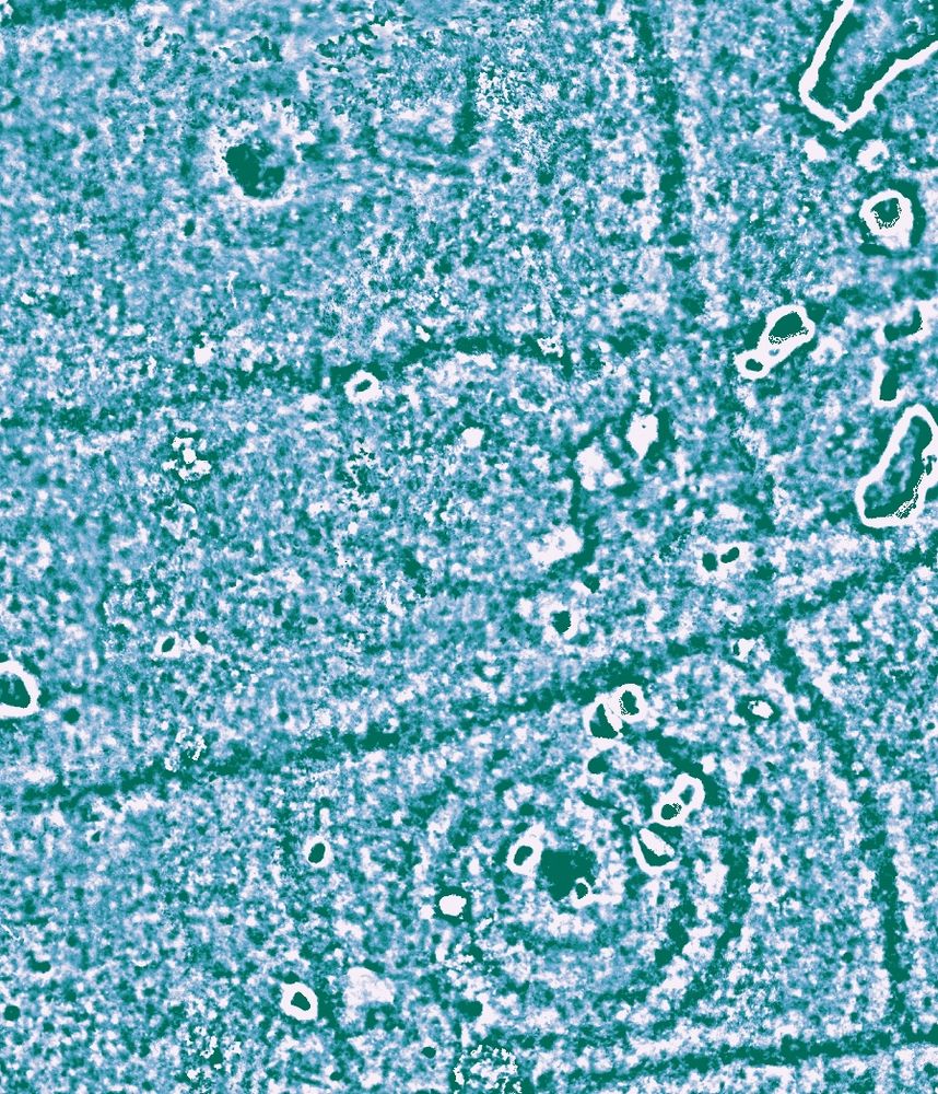
Is that your own photo?
October 27, 2025 at 3:29 PM
Is that your own photo?
Have you played with performing local relief models on them? That was my first thought, and seems to work well for pulling out unseen etchings.

October 26, 2025 at 3:33 PM
Have you played with performing local relief models on them? That was my first thought, and seems to work well for pulling out unseen etchings.
Cheers. This is incredibly useful.
October 26, 2025 at 2:57 PM
Cheers. This is incredibly useful.
Fantastic, cheers Tom.
Any links to those papers on specific sites? Would be good to see these methods in action.
Any links to those papers on specific sites? Would be good to see these methods in action.
October 26, 2025 at 2:48 PM
Fantastic, cheers Tom.
Any links to those papers on specific sites? Would be good to see these methods in action.
Any links to those papers on specific sites? Would be good to see these methods in action.
Amazing, cheers Tom! I happened upon it via Cloud Compare.
I did mesh, to pointcloud, to raster, to geotiff.
Do you have any papers on it? I’d love to keep building on it.
I did mesh, to pointcloud, to raster, to geotiff.
Do you have any papers on it? I’d love to keep building on it.
October 26, 2025 at 2:38 PM
Amazing, cheers Tom! I happened upon it via Cloud Compare.
I did mesh, to pointcloud, to raster, to geotiff.
Do you have any papers on it? I’d love to keep building on it.
I did mesh, to pointcloud, to raster, to geotiff.
Do you have any papers on it? I’d love to keep building on it.
Here's a 'hillshade' model of the one I originally posted!

October 26, 2025 at 2:27 PM
Here's a 'hillshade' model of the one I originally posted!
It's a method I stumbled upon by accident a few weeks ago. You can analyse photogrammetry / LiDAR scans in GIS software. So, you can perform hillshade, slope, etcetera on rock art! Very useful.
It'd work wonders on Long Meg / Copt Howe. So they're next on my list.
It'd work wonders on Long Meg / Copt Howe. So they're next on my list.

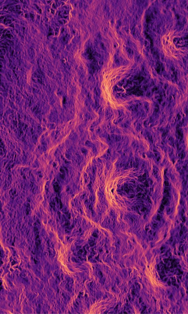
October 26, 2025 at 2:18 PM
It's a method I stumbled upon by accident a few weeks ago. You can analyse photogrammetry / LiDAR scans in GIS software. So, you can perform hillshade, slope, etcetera on rock art! Very useful.
It'd work wonders on Long Meg / Copt Howe. So they're next on my list.
It'd work wonders on Long Meg / Copt Howe. So they're next on my list.
The mysterious discovery of Hadrian’s Wall in the Amazon jungle…
Would sell books.
Would sell books.
October 26, 2025 at 1:10 PM
The mysterious discovery of Hadrian’s Wall in the Amazon jungle…
Would sell books.
Would sell books.
@joanavaldez.bsky.social - do you know of anyone using a similar method to identify rock art??
October 18, 2025 at 5:48 PM
@joanavaldez.bsky.social - do you know of anyone using a similar method to identify rock art??
I love to read “excavations in 2025”.
October 8, 2025 at 5:00 PM
I love to read “excavations in 2025”.