


Tyler Hamilton
@50shadesofvan.bsky.social
A coffee drinking cyclist who happens to be a meteorologist.
Aggressive day 3 outlook issued by the SPC - An upper trough pumps a mild, unstable southerly flow bringing with it the chance of severe thunderstorms across the Pacific Northwest.


March 24, 2025 at 4:43 PM
Aggressive day 3 outlook issued by the SPC - An upper trough pumps a mild, unstable southerly flow bringing with it the chance of severe thunderstorms across the Pacific Northwest.
A look at the power outage threat with a potent, compact low approaching the South Coast Monday evening - localized, but high impacts possible!

February 24, 2025 at 9:41 PM
A look at the power outage threat with a potent, compact low approaching the South Coast Monday evening - localized, but high impacts possible!
Storm fatigue at its peak: A 975 hPa low south of Tofino is forecast for Boxing Day, far inside 130°W. Another round of damaging winds and widespread power outages are expected. #BCStorm


December 24, 2024 at 10:46 PM
Storm fatigue at its peak: A 975 hPa low south of Tofino is forecast for Boxing Day, far inside 130°W. Another round of damaging winds and widespread power outages are expected. #BCStorm
So, next weekend, the western shores of Hudson Bay will experience temperatures up to 28 degrees above normal, and rainfall will likely be reported across the bay.


December 24, 2024 at 8:17 PM
So, next weekend, the western shores of Hudson Bay will experience temperatures up to 28 degrees above normal, and rainfall will likely be reported across the bay.
There is a very high risk of outages for northern sections of the Strait of Georgia, where 100-110 km/h wind gusts are possible over the immediate coastline. Please stay safe! #BCStorm

December 23, 2024 at 7:38 PM
There is a very high risk of outages for northern sections of the Strait of Georgia, where 100-110 km/h wind gusts are possible over the immediate coastline. Please stay safe! #BCStorm
Remarkable satellite presentation on a rapidly developing low, with a final destination south of Haida Gwaii pre-dawn Tuesday at 960 hPa. #BCStorm
December 23, 2024 at 7:09 PM
Remarkable satellite presentation on a rapidly developing low, with a final destination south of Haida Gwaii pre-dawn Tuesday at 960 hPa. #BCStorm
Carefully watching a powerful low approach the NW tip of Vancouver Island pre-dawn Christmas Eve. A low inside 130°W with this pressure normally spells pretty big trouble with power outages and damage for Vancouver Island. #BCStorm

December 21, 2024 at 2:26 PM
Carefully watching a powerful low approach the NW tip of Vancouver Island pre-dawn Christmas Eve. A low inside 130°W with this pressure normally spells pretty big trouble with power outages and damage for Vancouver Island. #BCStorm
Classic windstorm for the Lower Mainland on Saturday, with gusts over 90 km/h across the SW, but 80+ km/h wind gusts are fair game well inland. #BCStorm
December 14, 2024 at 2:37 PM
Classic windstorm for the Lower Mainland on Saturday, with gusts over 90 km/h across the SW, but 80+ km/h wind gusts are fair game well inland. #BCStorm
Peak winds for most are Saturday morning, easing later Saturday afternoon and evening. For those venturing to the beaches, sustained winds likely touch 70 km/h, the speed where walking and standing becomes more difficult.

December 14, 2024 at 1:39 AM
Peak winds for most are Saturday morning, easing later Saturday afternoon and evening. For those venturing to the beaches, sustained winds likely touch 70 km/h, the speed where walking and standing becomes more difficult.
Widespread power outages are likely, with over a quarter of a million residents potentially losing power. Classic track with the low weakening just northwest of Tofino. Lots of ferry cancellations through through Saturday.

December 14, 2024 at 1:39 AM
Widespread power outages are likely, with over a quarter of a million residents potentially losing power. Classic track with the low weakening just northwest of Tofino. Lots of ferry cancellations through through Saturday.
The streak of windstorms continues… (1/3🧵) #BCStorm
The forecast is straightforward: if you live along the water, expect wind gusts of up to 100 km/h. The North Island will see much less impact compared to the recent bomb cyclone.
The forecast is straightforward: if you live along the water, expect wind gusts of up to 100 km/h. The North Island will see much less impact compared to the recent bomb cyclone.

December 14, 2024 at 1:39 AM
The streak of windstorms continues… (1/3🧵) #BCStorm
The forecast is straightforward: if you live along the water, expect wind gusts of up to 100 km/h. The North Island will see much less impact compared to the recent bomb cyclone.
The forecast is straightforward: if you live along the water, expect wind gusts of up to 100 km/h. The North Island will see much less impact compared to the recent bomb cyclone.
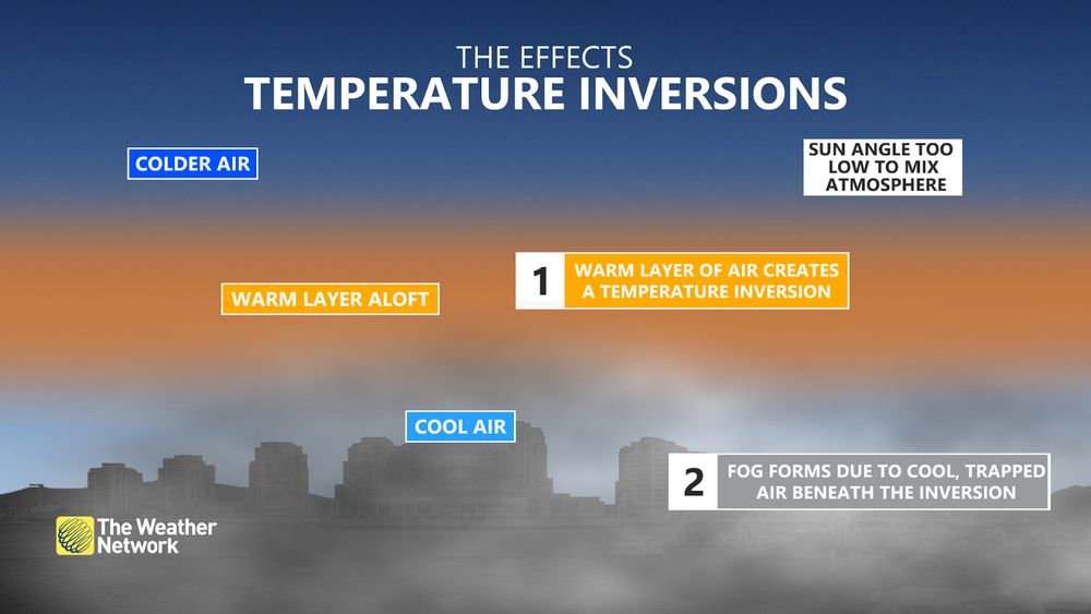
Surface air quality can be impacted with the warm air aloft acting as a “lid,” trapping fine particulate matter.
November 27, 2024 at 2:34 PM
Surface air quality can be impacted with the warm air aloft acting as a “lid,” trapping fine particulate matter.
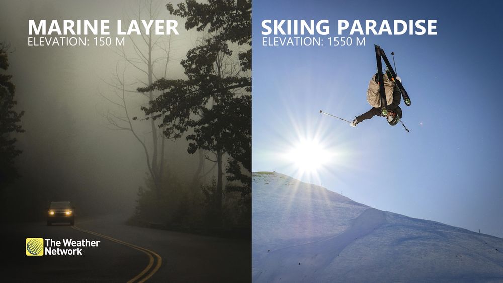
Want to escape the gloom? Up, up and away!
November 27, 2024 at 2:34 PM
Want to escape the gloom? Up, up and away!
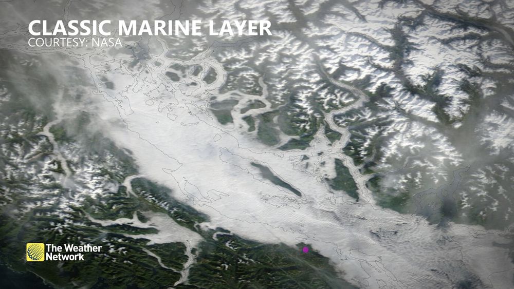
Here’s the classic result—our marine layer blanket gets extra cozy along the coast.
November 27, 2024 at 2:34 PM
Here’s the classic result—our marine layer blanket gets extra cozy along the coast.
The atmosphere is pulling off its best impersonation of a Tim Hortons Smile Cookie this week.

November 21, 2024 at 2:27 AM
The atmosphere is pulling off its best impersonation of a Tim Hortons Smile Cookie this week.
A look at the latest wind velocity scans. For those not familiar, the colours represent wind movement relative to the radar, with reds indicating winds moving away from the radar at Halfmoon Peak and greens/blues showing winds moving toward it. #BCstorm
November 20, 2024 at 4:51 AM
A look at the latest wind velocity scans. For those not familiar, the colours represent wind movement relative to the radar, with reds indicating winds moving away from the radar at Halfmoon Peak and greens/blues showing winds moving toward it. #BCstorm
90 km/h winds might not sound impressive to the rest of Canada, but for the South Coast of B.C., this is why they’re a big deal.🌲💨#BCStorm

November 20, 2024 at 1:42 AM
90 km/h winds might not sound impressive to the rest of Canada, but for the South Coast of B.C., this is why they’re a big deal.🌲💨#BCStorm
Some fresh satellite shots are painting quite the picture, looking at another 10 hPa of deepening the next few hours
November 19, 2024 at 11:04 PM
Some fresh satellite shots are painting quite the picture, looking at another 10 hPa of deepening the next few hours
Buoy 46005 is going through it right now.

November 19, 2024 at 10:35 PM
Buoy 46005 is going through it right now.
Textbook strong mid-latitude cyclone. The tight comma look and strong frontal boundaries highlight the rapid intensification. It's driven by the warm and cold airmass interaction, creating rapid upward motion. Note the stratocumulus clouds wrapping behind (popcorn-like) highlighting the cold air.

November 19, 2024 at 7:32 PM
Textbook strong mid-latitude cyclone. The tight comma look and strong frontal boundaries highlight the rapid intensification. It's driven by the warm and cold airmass interaction, creating rapid upward motion. Note the stratocumulus clouds wrapping behind (popcorn-like) highlighting the cold air.
The model guidance suggests a significant windstorm is likely for all of Vancouver Island, potentially affecting 200,000+ customers. Unlike typical wind events that last 6 to 8 hours, this storm is expected to persist for twice that duration and not be isolated. #BCStorm
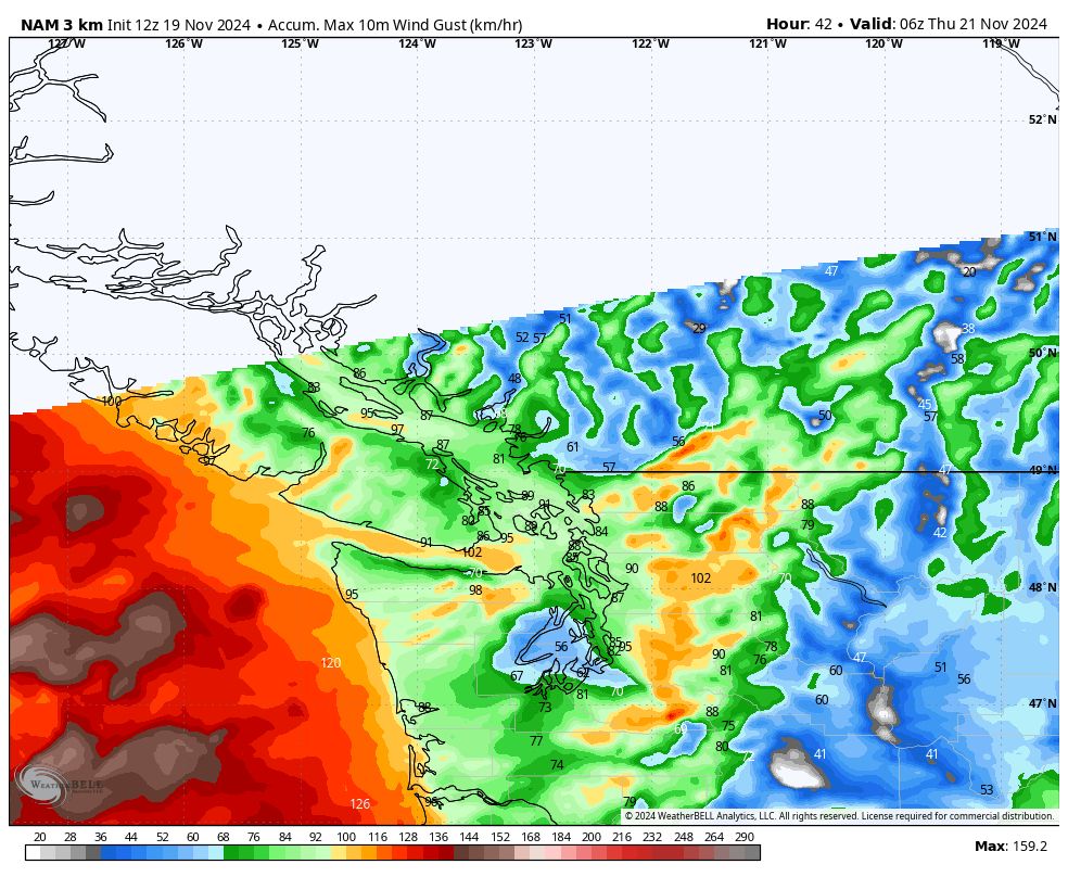
November 19, 2024 at 7:10 PM
The model guidance suggests a significant windstorm is likely for all of Vancouver Island, potentially affecting 200,000+ customers. Unlike typical wind events that last 6 to 8 hours, this storm is expected to persist for twice that duration and not be isolated. #BCStorm
Textbook rapidly developing low. Compact swirling center, comma shaped look, dry air intrusion on the backside, and a budding baroclinic leaf (cloud band) to the north. #BCStorm

November 19, 2024 at 2:21 PM
Textbook rapidly developing low. Compact swirling center, comma shaped look, dry air intrusion on the backside, and a budding baroclinic leaf (cloud band) to the north. #BCStorm
Oops it looks like GIF’s aren’t working on BlueSky but here’s a hi res shot to fill the void.

November 19, 2024 at 2:06 PM
Oops it looks like GIF’s aren’t working on BlueSky but here’s a hi res shot to fill the void.

