

Warning‼️ 🚨 This is now an FPGA & GPU complaint account‼️ Q4 will be mostly skill issue posts.
September 27, 2025 at 9:33 PM
Warning‼️ 🚨 This is now an FPGA & GPU complaint account‼️ Q4 will be mostly skill issue posts.
Coming down with the sickness again, maybe there are codebase visualizations that are useful. Interactive with bidirectional editor integration and runtime analysis. Apologies for the slop prototype.
September 22, 2025 at 10:12 PM
Coming down with the sickness again, maybe there are codebase visualizations that are useful. Interactive with bidirectional editor integration and runtime analysis. Apologies for the slop prototype.
The VGGT vision transformer model couldn't really handle mixed time of day images, but this new Apache-2 licensed model is a big step up. Variable lighting and weather really mess with existing VPS solutions. A popular one needs two scans at least 5 hours apart. map-anything.github.io
September 17, 2025 at 3:47 PM
The VGGT vision transformer model couldn't really handle mixed time of day images, but this new Apache-2 licensed model is a big step up. Variable lighting and weather really mess with existing VPS solutions. A popular one needs two scans at least 5 hours apart. map-anything.github.io
happy tom7 day to those that celebrate. www.youtube.com/watch?v=QH4M...

Rupert's Snub Cube and other Math Holes
YouTube video by suckerpinch
www.youtube.com
September 17, 2025 at 4:45 AM
happy tom7 day to those that celebrate. www.youtube.com/watch?v=QH4M...
Butlerian Jihad at home. 2010s programming just to feel something.

September 5, 2025 at 4:35 PM
Butlerian Jihad at home. 2010s programming just to feel something.
Got the mesh registration to run in ~100ms, down from 400ms, by fusing the kernels and moving the correspondence work to the gpu. The extra time is from deserializing the test data. bsky.app/profile/v1se...
August 30, 2025 at 1:31 PM
Got the mesh registration to run in ~100ms, down from 400ms, by fusing the kernels and moving the correspondence work to the gpu. The extra time is from deserializing the test data. bsky.app/profile/v1se...
The VGGT model works as a VPS with only a few images. One attention head estimates the 6dof camera pose of each image. Here is a rough example with 7 warped Mapillary images and 1 XR headset camera image in red. While the error is about 2m, you couldn't do this at all with SfM.
August 29, 2025 at 2:50 AM
The VGGT model works as a VPS with only a few images. One attention head estimates the 6dof camera pose of each image. Here is a rough example with 7 warped Mapillary images and 1 XR headset camera image in red. While the error is about 2m, you couldn't do this at all with SfM.
Making block worlds spherical comes with a lot of trade-off. I think this person made some smart compromises such as the vertical block layers.
For an AR world-wide block game this is great as all worlds can use the same earth centered origin.
For an AR world-wide block game this is great as all worlds can use the same earth centered origin.

Blocky Planet — My attempt at making spherical planets with Minecraft-style blocks.

August 29, 2025 at 2:17 AM
Making block worlds spherical comes with a lot of trade-off. I think this person made some smart compromises such as the vertical block layers.
For an AR world-wide block game this is great as all worlds can use the same earth centered origin.
For an AR world-wide block game this is great as all worlds can use the same earth centered origin.
I got some very promising 3d sidewalk point cloud data from unwarping Mapillary data and feeding it to VGGT(Visual Geometry Grounded Transformer). The output seems much better than traditional Structure from Motion + Multi-View Stereo dense reconstruction.
August 14, 2025 at 10:59 PM
I got some very promising 3d sidewalk point cloud data from unwarping Mapillary data and feeding it to VGGT(Visual Geometry Grounded Transformer). The output seems much better than traditional Structure from Motion + Multi-View Stereo dense reconstruction.
I think I've hit the limit for GPS accuracy in the city for AR positioning. One path forward could be doing mesh registration on a 3d model of the city. Maybe by running Structure from Motion on the street level Mapillary data. Maybe combined with USGS airborne Lidar.


August 10, 2025 at 12:35 AM
I think I've hit the limit for GPS accuracy in the city for AR positioning. One path forward could be doing mesh registration on a 3d model of the city. Maybe by running Structure from Motion on the street level Mapillary data. Maybe combined with USGS airborne Lidar.
Demo: while you were living in sin I was studying the GNSS.
August 9, 2025 at 7:16 AM
Demo: while you were living in sin I was studying the GNSS.
Alleyway GPS sensor fusion test. Head position in white. GPS in red. Fused state in green. It is tuned for open fields and forests, but maybe with a bit more math this could hit sub meter accuracy. At this scale the odometry is very accurate.
August 7, 2025 at 10:26 PM
Alleyway GPS sensor fusion test. Head position in white. GPS in red. Fused state in green. It is tuned for open fields and forests, but maybe with a bit more math this could hit sub meter accuracy. At this scale the odometry is very accurate.
So you want to build Mountain-Scale AR for current hardware? Maybe like Snap's Spectacles devkit does it now? For vision pro you can do this by reading the headset position(odometry) and a iPhone gps position.
August 6, 2025 at 6:39 AM
So you want to build Mountain-Scale AR for current hardware? Maybe like Snap's Spectacles devkit does it now? For vision pro you can do this by reading the headset position(odometry) and a iPhone gps position.
I was surprised to find NOAA publishes the 3d weather forecast data for the continental US + Alaska. This appears to match observations of nearby mountains. Very little smoke today. I get why hiking apps don't provide search on this data now :), but there might be a way.


August 4, 2025 at 12:00 AM
I was surprised to find NOAA publishes the 3d weather forecast data for the continental US + Alaska. This appears to match observations of nearby mountains. Very little smoke today. I get why hiking apps don't provide search on this data now :), but there might be a way.
Would anyone actually try a free outdoor navigation app for the vision pro? The tech works in the mountains, but it is too dangerous to recommend outside flat parks. My initial tests were putting a 10m tall pushpin at a gps coordinate and keeping it there for miles.
July 31, 2025 at 1:23 AM
Would anyone actually try a free outdoor navigation app for the vision pro? The tech works in the mountains, but it is too dangerous to recommend outside flat parks. My initial tests were putting a 10m tall pushpin at a gps coordinate and keeping it there for miles.
Approved, ping me for a copy or if you have any issues. bsky.app/profile/v1se...
Demo showing Claude building a race car with voxels. The UI is all buttoned up now, hopefully app review approves this feature.
July 30, 2025 at 11:50 PM
Approved, ping me for a copy or if you have any issues. bsky.app/profile/v1se...
Demo showing Claude building a race car with voxels. The UI is all buttoned up now, hopefully app review approves this feature.
July 30, 2025 at 1:44 AM
Demo showing Claude building a race car with voxels. The UI is all buttoned up now, hopefully app review approves this feature.
Today was such a beautiful summer day for a hike according to my database.
July 27, 2025 at 10:04 PM
Today was such a beautiful summer day for a hike according to my database.
AI agent that commutes around on the real-time transit data. posts about missing a transfer. call it Claude Commute.
July 26, 2025 at 5:56 PM
AI agent that commutes around on the real-time transit data. posts about missing a transfer. call it Claude Commute.
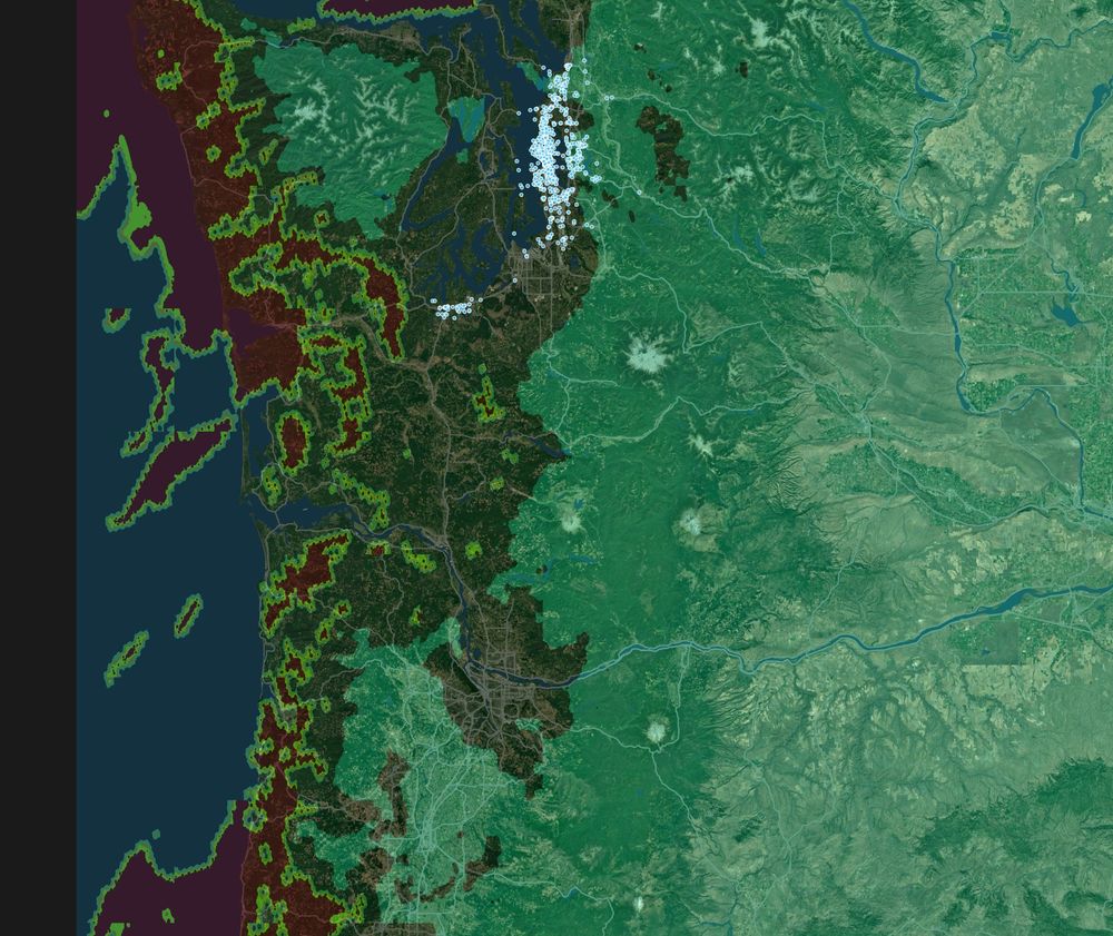
Working on a little website to find hikes. One feature is filtering by weather forecast. Very thankful for the open data from NOAA and the USGS. All the blue dots are the real-time positions of nearly 1000 buses and ferries.
July 24, 2025 at 3:16 PM
Working on a little website to find hikes. One feature is filtering by weather forecast. Very thankful for the open data from NOAA and the USGS. All the blue dots are the real-time positions of nearly 1000 buses and ferries.
Claude and I friendmaxxing at the beach.
July 21, 2025 at 5:17 AM
Claude and I friendmaxxing at the beach.
This is claude-sonnet-4-20250514 building a sand castle via the CRDT ops after 16 seconds of thinking.
July 14, 2025 at 10:20 AM
This is claude-sonnet-4-20250514 building a sand castle via the CRDT ops after 16 seconds of thinking.
Little faster. Now it does 4296.3 CRDT ops/sec (6x faster) and chunk meshing is 192μs (78x faster)
July 14, 2025 at 12:53 AM
Little faster. Now it does 4296.3 CRDT ops/sec (6x faster) and chunk meshing is 192μs (78x faster)
WIP: performance test for the CRDT. Getting around 637.9 ops/sec with intermittent state compaction.
July 12, 2025 at 9:03 PM
WIP: performance test for the CRDT. Getting around 637.9 ops/sec with intermittent state compaction.
I can't put much more time into this project. One goal was to get a job working in XR. This did not pan out. I'm grateful for the support I've received here. Thank you.
July 10, 2025 at 3:36 PM
I can't put much more time into this project. One goal was to get a job working in XR. This did not pan out. I'm grateful for the support I've received here. Thank you.