


TTWeatherCenter
@ttweathercenter.bsky.social
Disseminating information on natural hazards for Trinidad and Tobago and Lesser Antilles
3:45 PM - Widely scattered, light to moderate rain is ongoing near and across much of the Windward Islands, including Barbados and T&T.
Adverse Weather Alert in effect through 4 PM Thursday for T&T: ttweathercenter.com/2025/12/03/a...
Adverse Weather Alert in effect through 4 PM Thursday for T&T: ttweathercenter.com/2025/12/03/a...
December 3, 2025 at 7:48 PM
3:45 PM - Widely scattered, light to moderate rain is ongoing near and across much of the Windward Islands, including Barbados and T&T.
Adverse Weather Alert in effect through 4 PM Thursday for T&T: ttweathercenter.com/2025/12/03/a...
Adverse Weather Alert in effect through 4 PM Thursday for T&T: ttweathercenter.com/2025/12/03/a...
Impacts from today's inclement weather were primarily in northeastern Trinidad, particularly in the Sangre Grande area.
With additional rainfall tonight and tomorrow, street/flash flooding, landslides, and fallen trees remain likely.
Read more: ttweathercenter.com/2025/12/03/a...
With additional rainfall tonight and tomorrow, street/flash flooding, landslides, and fallen trees remain likely.
Read more: ttweathercenter.com/2025/12/03/a...

December 3, 2025 at 7:22 PM
Impacts from today's inclement weather were primarily in northeastern Trinidad, particularly in the Sangre Grande area.
With additional rainfall tonight and tomorrow, street/flash flooding, landslides, and fallen trees remain likely.
Read more: ttweathercenter.com/2025/12/03/a...
With additional rainfall tonight and tomorrow, street/flash flooding, landslides, and fallen trees remain likely.
Read more: ttweathercenter.com/2025/12/03/a...
Parts of eastern T&T have picked up between 75 and 100 mm (3-4 inches) of rainfall over the last 36 hours, leading to flooding, landslides, and fallen trees.
With more rainfall expected through tomorrow, the Adverse Weather Alert remains in effect:
ttweathercenter.com/2025/12/03/a...
With more rainfall expected through tomorrow, the Adverse Weather Alert remains in effect:
ttweathercenter.com/2025/12/03/a...

Adverse Weather Alert Remains In Effect For T&T
Periods of rain have led to flooding, fallen trees, and landslides across parts of eastern Trinidad and Tobago.
ttweathercenter.com
December 3, 2025 at 6:40 PM
Parts of eastern T&T have picked up between 75 and 100 mm (3-4 inches) of rainfall over the last 36 hours, leading to flooding, landslides, and fallen trees.
With more rainfall expected through tomorrow, the Adverse Weather Alert remains in effect:
ttweathercenter.com/2025/12/03/a...
With more rainfall expected through tomorrow, the Adverse Weather Alert remains in effect:
ttweathercenter.com/2025/12/03/a...
A deep-layered trough is forecast to produce unsettled weather from Tuesday night, prompting the TTMS to issue an Adverse Weather Alert for T&T.
Main hazards: Street/flash flooding, gusty winds, landslides, and lightning in thunderstorms.
Read more: ttweathercenter.com/2025/12/02/a...
Main hazards: Street/flash flooding, gusty winds, landslides, and lightning in thunderstorms.
Read more: ttweathercenter.com/2025/12/02/a...
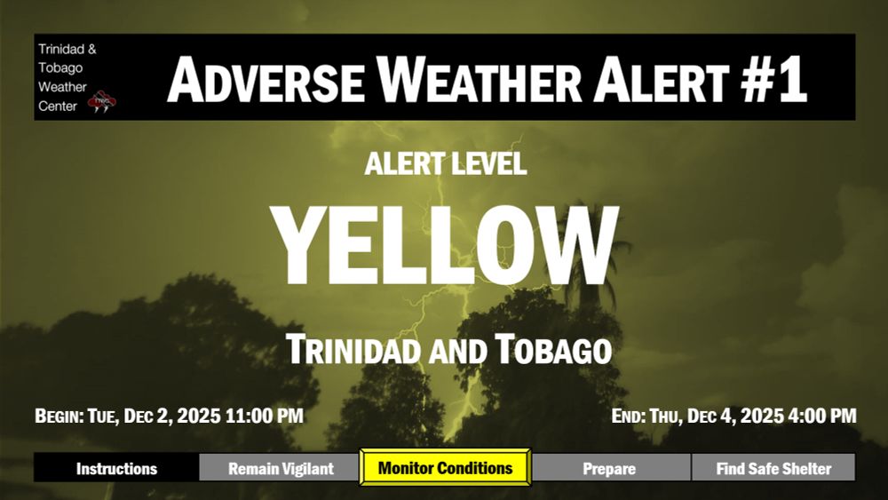
Adverse Weather Alert In Effect For T&T From 11 PM Tuesday
Unsettled weather is forecast from Tuesday night, prompting the TTMS to issue an Adverse Weather Alert for T&T through Thursday.
ttweathercenter.com
December 2, 2025 at 7:29 PM
A deep-layered trough is forecast to produce unsettled weather from Tuesday night, prompting the TTMS to issue an Adverse Weather Alert for T&T.
Main hazards: Street/flash flooding, gusty winds, landslides, and lightning in thunderstorms.
Read more: ttweathercenter.com/2025/12/02/a...
Main hazards: Street/flash flooding, gusty winds, landslides, and lightning in thunderstorms.
Read more: ttweathercenter.com/2025/12/02/a...
River levels across Trinidad are elevated following two days of rainfall, but a slow and steady decrease is forecast with low tide at 1:39 AM.
The Caroni River at Tumpuna is at 92% and cresting, while at El Carmen (downstream), the river is rising, at 94%.
ttweathercenter.com/2025/11/25/a...
The Caroni River at Tumpuna is at 92% and cresting, while at El Carmen (downstream), the river is rising, at 94%.
ttweathercenter.com/2025/11/25/a...

November 26, 2025 at 4:41 AM
River levels across Trinidad are elevated following two days of rainfall, but a slow and steady decrease is forecast with low tide at 1:39 AM.
The Caroni River at Tumpuna is at 92% and cresting, while at El Carmen (downstream), the river is rising, at 94%.
ttweathercenter.com/2025/11/25/a...
The Caroni River at Tumpuna is at 92% and cresting, while at El Carmen (downstream), the river is rising, at 94%.
ttweathercenter.com/2025/11/25/a...
Already, between 25 and 50 millimeters of rainfall has accumulated across northern and parts of eastern Trinidad since midnight, with wind gusts exceeding 55 km/h recorded at Crown Point, Tobago, in heavy showers.
Adverse Weather Alert in effect: ttweathercenter.com/2025/11/25/a...
Adverse Weather Alert in effect: ttweathercenter.com/2025/11/25/a...

Adverse Weather Alert In Effect As Unsettled Weather Spreads Across T&T
Trinidad and Tobago is forecast to experience unsettled weather on Tuesday, prompting an Adverse Weather Alert.
ttweathercenter.com
November 25, 2025 at 3:27 PM
Already, between 25 and 50 millimeters of rainfall has accumulated across northern and parts of eastern Trinidad since midnight, with wind gusts exceeding 55 km/h recorded at Crown Point, Tobago, in heavy showers.
Adverse Weather Alert in effect: ttweathercenter.com/2025/11/25/a...
Adverse Weather Alert in effect: ttweathercenter.com/2025/11/25/a...
8:25 AM - A wind gust of 63 km/h was recorded at Crown Point, Tobago, during a heavy shower.
ttweathercenter.com/2025/11/24/a...
ttweathercenter.com/2025/11/24/a...

November 25, 2025 at 1:30 PM
8:25 AM - A wind gust of 63 km/h was recorded at Crown Point, Tobago, during a heavy shower.
ttweathercenter.com/2025/11/24/a...
ttweathercenter.com/2025/11/24/a...
Locally heavy rainfall, gusty winds, and street/flash flooding are all likely on Tuesday according to the TTMS, with forecast unsettled weather prompting an Adverse Weather Alert.
The Alert is in effect for Trinidad and Tobago from 5:00 AM Tuesday.
ttweathercenter.com/2025/11/24/a...
The Alert is in effect for Trinidad and Tobago from 5:00 AM Tuesday.
ttweathercenter.com/2025/11/24/a...

Adverse Weather Alert Issued For T&T
Trinidad and Tobago is forecast to experience unsettled weather on Tuesday, prompting an Adverse Weather Alert.
ttweathercenter.com
November 24, 2025 at 8:25 PM
Locally heavy rainfall, gusty winds, and street/flash flooding are all likely on Tuesday according to the TTMS, with forecast unsettled weather prompting an Adverse Weather Alert.
The Alert is in effect for Trinidad and Tobago from 5:00 AM Tuesday.
ttweathercenter.com/2025/11/24/a...
The Alert is in effect for Trinidad and Tobago from 5:00 AM Tuesday.
ttweathercenter.com/2025/11/24/a...
2:00 PM - Light to moderate rainfall is ongoing across much of Trinidad, interrupting overcast skies. Across eastern and northeastern areas, locally heavy rain associated with weak thunderstorms is ongoing. Across Tobago, cloudy skies continue with few showers across eastern areas.

November 20, 2025 at 7:02 PM
2:00 PM - Light to moderate rainfall is ongoing across much of Trinidad, interrupting overcast skies. Across eastern and northeastern areas, locally heavy rain associated with weak thunderstorms is ongoing. Across Tobago, cloudy skies continue with few showers across eastern areas.
The TTMS has discontinued the Adverse Weather Alert, as rainfall of varying intensity and flooding continue across parts of Trinidad.
Parts of central and southern Trinidad have already recorded between 50 and 65 mm.
Read more: ttweathercenter.com/2025/11/20/t...
Parts of central and southern Trinidad have already recorded between 50 and 65 mm.
Read more: ttweathercenter.com/2025/11/20/t...

TTMS: Adverse Weather Alert Discontinued. Rainfall Ongoing
The TTMS has discontinued the Adverse Weather Alert, as rainfall of varying intensity and flooding continue across parts of Trinidad.
ttweathercenter.com
November 20, 2025 at 5:49 PM
The TTMS has discontinued the Adverse Weather Alert, as rainfall of varying intensity and flooding continue across parts of Trinidad.
Parts of central and southern Trinidad have already recorded between 50 and 65 mm.
Read more: ttweathercenter.com/2025/11/20/t...
Parts of central and southern Trinidad have already recorded between 50 and 65 mm.
Read more: ttweathercenter.com/2025/11/20/t...
Flooding is ongoing across various parts of Trinidad as moderate to heavy rainfall continues.
Additional street/flash flooding, landslides, and gusty winds remain possible due to heavy rainfall.
Adverse Weather Alert extended until 4 PM: ttweathercenter.com/2025/11/20/a...
Additional street/flash flooding, landslides, and gusty winds remain possible due to heavy rainfall.
Adverse Weather Alert extended until 4 PM: ttweathercenter.com/2025/11/20/a...

Adverse Weather Alert Extended For T&T Until 4 PM
Heavy rainfall across T&T has produced localized flooding, prompting an extension of the Adverse Weather Alert.
ttweathercenter.com
November 20, 2025 at 5:26 PM
Flooding is ongoing across various parts of Trinidad as moderate to heavy rainfall continues.
Additional street/flash flooding, landslides, and gusty winds remain possible due to heavy rainfall.
Adverse Weather Alert extended until 4 PM: ttweathercenter.com/2025/11/20/a...
Additional street/flash flooding, landslides, and gusty winds remain possible due to heavy rainfall.
Adverse Weather Alert extended until 4 PM: ttweathercenter.com/2025/11/20/a...
Trinidad and Tobago has been placed under an Adverse Weather Alert, with additional showers, thunderstorms, and rain forecast through today (Thursday).
Street/flash flooding, landslides, and gusty winds are likely in heavy rainfall.
Read more: ttweathercenter.com/2025/11/20/a...
Street/flash flooding, landslides, and gusty winds are likely in heavy rainfall.
Read more: ttweathercenter.com/2025/11/20/a...

Adverse Weather Alert In Effect Until 9:30 AM Today
Heavy rainfall continues to affect Trinidad and Tobago, prompting a brief, late-notice Adverse Weather Alert to be issued.
ttweathercenter.com
November 20, 2025 at 7:37 AM
Trinidad and Tobago has been placed under an Adverse Weather Alert, with additional showers, thunderstorms, and rain forecast through today (Thursday).
Street/flash flooding, landslides, and gusty winds are likely in heavy rainfall.
Read more: ttweathercenter.com/2025/11/20/a...
Street/flash flooding, landslides, and gusty winds are likely in heavy rainfall.
Read more: ttweathercenter.com/2025/11/20/a...
Severe wind gusts are no longer likely, but occasional gusty winds (up to 50 km/h) remain possible through Wednesday near showers.
ttweathercenter.com/2025/11/18/h...
ttweathercenter.com/2025/11/18/h...

High Wind Alert Discontinued. Occasional Gusts Still Forecast
Severe wind gusts are no longer likely, but occasional gusty winds remain possible through Wednesday near showers.
ttweathercenter.com
November 19, 2025 at 3:57 AM
Severe wind gusts are no longer likely, but occasional gusty winds (up to 50 km/h) remain possible through Wednesday near showers.
ttweathercenter.com/2025/11/18/h...
ttweathercenter.com/2025/11/18/h...
On Tuesday night, a trio of light earthquakes, recorded at magnitudes 4.0 to 4.4, struck northwest of Trinidad.
Details: ttweathercenter.com/2025/11/18/t...
Details: ttweathercenter.com/2025/11/18/t...

Trinidad Shaken By Trio Of Earthquakes
Three earthquakes struck northwest of Trinidad within a 30-minute span that resulted in shaking across parts of T&T.
ttweathercenter.com
November 19, 2025 at 3:34 AM
On Tuesday night, a trio of light earthquakes, recorded at magnitudes 4.0 to 4.4, struck northwest of Trinidad.
Details: ttweathercenter.com/2025/11/18/t...
Details: ttweathercenter.com/2025/11/18/t...
A High Wind Alert goes into effect for T&T at 6:15 PM this evening through 7:45 PM tonight. Weaker gusts may persist in the vicinity of overnight showers, with varying intensity, even after the alert period.
ttweathercenter.com/2025/11/18/b...
ttweathercenter.com/2025/11/18/b...

November 18, 2025 at 10:10 PM
A High Wind Alert goes into effect for T&T at 6:15 PM this evening through 7:45 PM tonight. Weaker gusts may persist in the vicinity of overnight showers, with varying intensity, even after the alert period.
ttweathercenter.com/2025/11/18/b...
ttweathercenter.com/2025/11/18/b...
9:00 PM - A line of moderate to heavy showers, associated with trailing convergence behind Invest #98L, is moving toward T&T. Rainfall is forecast to move across Tobago within the hour, and across eastern areas of Trinidad near midnight.
ttweathercenter.com/2025/10/20/t...
ttweathercenter.com/2025/10/20/t...
October 21, 2025 at 1:09 AM
9:00 PM - A line of moderate to heavy showers, associated with trailing convergence behind Invest #98L, is moving toward T&T. Rainfall is forecast to move across Tobago within the hour, and across eastern areas of Trinidad near midnight.
ttweathercenter.com/2025/10/20/t...
ttweathercenter.com/2025/10/20/t...
JUST IN: The TTMS has discontinued the Adverse Weather Alert for T&T.
However, periodic showers and isolated thunderstorms are likely to continue in some areas, a steady decrease in the frequency and intensity is expected as the evening and night progresses.
ttweathercenter.com/2025/10/20/t...
However, periodic showers and isolated thunderstorms are likely to continue in some areas, a steady decrease in the frequency and intensity is expected as the evening and night progresses.
ttweathercenter.com/2025/10/20/t...

TTMS: Adverse Weather Alert Discontinued For T&T
Isolated showers and thunderstorms are still forecast for T&T overnight, with the risk of street/flash flooding, gusty winds and landslides.
ttweathercenter.com
October 20, 2025 at 9:32 PM
JUST IN: The TTMS has discontinued the Adverse Weather Alert for T&T.
However, periodic showers and isolated thunderstorms are likely to continue in some areas, a steady decrease in the frequency and intensity is expected as the evening and night progresses.
ttweathercenter.com/2025/10/20/t...
However, periodic showers and isolated thunderstorms are likely to continue in some areas, a steady decrease in the frequency and intensity is expected as the evening and night progresses.
ttweathercenter.com/2025/10/20/t...
Another round of long-period swells are forecast to produce large, battering waves along T&T's northern coastlines, and to a lesser extent, north-facing coastlines of the Gulf of Paria.
ttweathercenter.com/2025/10/20/h...
ttweathercenter.com/2025/10/20/h...

Hazardous Seas Alert In Effect: Another Round Of Long Period Swells
Larger waves are forecast to affect T&T's coastlines over the next 24 hours due to long-period swells.
ttweathercenter.com
October 20, 2025 at 6:48 PM
Another round of long-period swells are forecast to produce large, battering waves along T&T's northern coastlines, and to a lesser extent, north-facing coastlines of the Gulf of Paria.
ttweathercenter.com/2025/10/20/h...
ttweathercenter.com/2025/10/20/h...
2:30 PM - As Invest #98L moves further west into the Caribbean Sea, trailing convergence continues to produce isolated to scattered showers and thunderstorms across T&T.
ttweathercenter.com/2025/10/20/a...
ttweathercenter.com/2025/10/20/a...

Adverse Weather Alert Remains In Effect Until 10 PM Today
One final day of isolated to scattered heavy showers and thunderstorms associated with Invest 98L across T&T.
ttweathercenter.com
October 20, 2025 at 6:48 PM
2:30 PM - As Invest #98L moves further west into the Caribbean Sea, trailing convergence continues to produce isolated to scattered showers and thunderstorms across T&T.
ttweathercenter.com/2025/10/20/a...
ttweathercenter.com/2025/10/20/a...
5:40 PM - Another cluster of strong thunderstorms is moving northward across southwestern Trinidad, producing locally heavy rainfall, gusty winds, and frequent lightning associated with Invest #98L.
ttweathercenter.com/2025/10/19/a...
ttweathercenter.com/2025/10/19/a...
October 19, 2025 at 9:40 PM
5:40 PM - Another cluster of strong thunderstorms is moving northward across southwestern Trinidad, producing locally heavy rainfall, gusty winds, and frequent lightning associated with Invest #98L.
ttweathercenter.com/2025/10/19/a...
ttweathercenter.com/2025/10/19/a...
UPDATE: Heavy rainfall and gusty winds are affecting parts of T&T as a strong tropical wave, Invest #98L, moves across the Windward Islands.
ttweathercenter.com/2025/10/19/a...
ttweathercenter.com/2025/10/19/a...

Adverse Weather Alert Remains In Effect As Tropical Disturbance Moves North of T&T
Heavy rainfall and gusty winds are affecting parts of T&T as a strong tropical wave moves across the Windward Islands.
ttweathercenter.com
October 19, 2025 at 7:02 PM
UPDATE: Heavy rainfall and gusty winds are affecting parts of T&T as a strong tropical wave, Invest #98L, moves across the Windward Islands.
ttweathercenter.com/2025/10/19/a...
ttweathercenter.com/2025/10/19/a...
2:20 PM - Invest #98L is producing scattered showers and thunderstorms from T&T northward to Guadeloupe. Wind gusts between 55 km/h and 75 km/h have been recorded across islands north of T&T.
ttweathercenter.com/2025/10/17/m...
ttweathercenter.com/2025/10/17/m...
October 19, 2025 at 7:01 PM
2:20 PM - Invest #98L is producing scattered showers and thunderstorms from T&T northward to Guadeloupe. Wind gusts between 55 km/h and 75 km/h have been recorded across islands north of T&T.
ttweathercenter.com/2025/10/17/m...
ttweathercenter.com/2025/10/17/m...
12:20 PM - Heavy showers and thunderstorms are moving inland across Tobago, associated with Invest #98L/Tropical Wave 44, as well as eastern Trinidad. Activity is moving generally W to NW across both islands, producing heavy rainfall, wind gusts, & lightning.
ttweathercenter.com/2025/10/17/m...
ttweathercenter.com/2025/10/17/m...

October 19, 2025 at 4:25 PM
12:20 PM - Heavy showers and thunderstorms are moving inland across Tobago, associated with Invest #98L/Tropical Wave 44, as well as eastern Trinidad. Activity is moving generally W to NW across both islands, producing heavy rainfall, wind gusts, & lightning.
ttweathercenter.com/2025/10/17/m...
ttweathercenter.com/2025/10/17/m...
11:30 AM - The center of Invest #98L, a tropical disturbance associated with Tropical Wave 44, is moving north of Tobago and south of Barbados this morning, producing scattered showers and thunderstorms.
ttweathercenter.com/2025/10/18/a...
ttweathercenter.com/2025/10/18/a...
October 19, 2025 at 3:30 PM
11:30 AM - The center of Invest #98L, a tropical disturbance associated with Tropical Wave 44, is moving north of Tobago and south of Barbados this morning, producing scattered showers and thunderstorms.
ttweathercenter.com/2025/10/18/a...
ttweathercenter.com/2025/10/18/a...
Although the Hazardous Seas Alert has been discontinued for T&T, larger-than-usual waves are still forecast as less-impactful long-period swells continue.
ttweathercenter.com/2025/10/18/h...
ttweathercenter.com/2025/10/18/h...

Hazardous Seas Alert Discontinued, Larger-than-usual Waves Still Forecast
The Hazardous Seas Alert has been discontinued but larger-than-usual waves are still forecast as less-impactful long-period swells continue.
ttweathercenter.com
October 18, 2025 at 7:56 PM
Although the Hazardous Seas Alert has been discontinued for T&T, larger-than-usual waves are still forecast as less-impactful long-period swells continue.
ttweathercenter.com/2025/10/18/h...
ttweathercenter.com/2025/10/18/h...