


@transkibton.bsky.social
#30daymapchallenge Day 11: Minimal. I went back to the Overture Maps Foundation building footprints for this one. The Towers of The Tower of London.

November 11, 2025 at 8:34 AM
#30daymapchallenge Day 11: Minimal. I went back to the Overture Maps Foundation building footprints for this one. The Towers of The Tower of London.
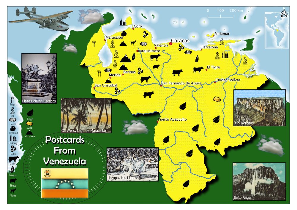
#30daymapchallenge Day 10: Air. Inspired by a PanAm map published in 1950 and the fact that PanAm flew daily from Miami to Maracaibo in Venezuela from 1927. The first regular flights landed on the lake.
November 10, 2025 at 8:16 AM
#30daymapchallenge Day 10: Air. Inspired by a PanAm map published in 1950 and the fact that PanAm flew daily from Miami to Maracaibo in Venezuela from 1927. The first regular flights landed on the lake.
#30daymapchallenge Day 9: Analog. A map made in an analogue age: 1978. My geography teacher took what looked like a paint roller, inked it up and rolled it into my exercise book for me to complete. Subject: Plate Tectonics. Projection: Mercator!

November 9, 2025 at 9:31 AM
#30daymapchallenge Day 9: Analog. A map made in an analogue age: 1978. My geography teacher took what looked like a paint roller, inked it up and rolled it into my exercise book for me to complete. Subject: Plate Tectonics. Projection: Mercator!
#30daymapchallenge Day 8: Urban. A map of buildings in central Brighton by use. I like that the individual buildings on the Pier have separate use types - including the helter-skelter! Building footprint data from the opensource Overture Map Foundation API.

November 8, 2025 at 9:05 AM
#30daymapchallenge Day 8: Urban. A map of buildings in central Brighton by use. I like that the individual buildings on the Pier have separate use types - including the helter-skelter! Building footprint data from the opensource Overture Map Foundation API.
#30daymapchallenge Day 7: Accessibility. Public access - 'the right to roam' - to land in England is complicated and limited. Here I've mapped public access land to land use type. Only 8% of the country is accessible and 10% of that is in residential areas.

November 7, 2025 at 8:36 AM
#30daymapchallenge Day 7: Accessibility. Public access - 'the right to roam' - to land in England is complicated and limited. Here I've mapped public access land to land use type. Only 8% of the country is accessible and 10% of that is in residential areas.
#30daymapchallenge Day 6: Dimensions. This map of Venezuela includes an elevation profile of the entire country. This is based on a line of latitude centred on Pico Bolivar, the highest point of the country in the Andes.

November 6, 2025 at 8:45 AM
#30daymapchallenge Day 6: Dimensions. This map of Venezuela includes an elevation profile of the entire country. This is based on a line of latitude centred on Pico Bolivar, the highest point of the country in the Andes.
#30daymapchallenge Day 5: Earth. The climate and soil in Sussex are ideal for growing vines and sparkling wine from the county is great quality and winning prizes. Here I've mapped the vineyards to the geology of the Weald. The earth is chalk and sandstone mostly - clay avoided. Cheers!

November 5, 2025 at 8:46 AM
#30daymapchallenge Day 5: Earth. The climate and soil in Sussex are ideal for growing vines and sparkling wine from the county is great quality and winning prizes. Here I've mapped the vineyards to the geology of the Weald. The earth is chalk and sandstone mostly - clay avoided. Cheers!
#30daymapchallenge Day 4: Data: My Data. This summer I cycled from home in Brighton, UK to Rouen in France to watch the Tour de France. This was my route - mapped in Official Tour de France route map style.

November 4, 2025 at 10:36 AM
#30daymapchallenge Day 4: Data: My Data. This summer I cycled from home in Brighton, UK to Rouen in France to watch the Tour de France. This was my route - mapped in Official Tour de France route map style.
#30daymapchallenge Day 3: Polygons. Inspired by a hand made map I spotted on a pub wall. I liked the colours and hatching used to make the legend for the global map. In QGIS it's hard to generate a scheme that works automatically for adjacent countries. To be honest the original map was better...

November 3, 2025 at 8:24 AM
#30daymapchallenge Day 3: Polygons. Inspired by a hand made map I spotted on a pub wall. I liked the colours and hatching used to make the legend for the global map. In QGIS it's hard to generate a scheme that works automatically for adjacent countries. To be honest the original map was better...
#30daymapchallenge Day 2: Lines. I got obsessed with Portolon Charts a while back so decided to have a go and make one in GIS - antique style. They are defined by their rhumblines. The intersections of those lines is quite messy so I can see why the mapmakers of old put a rose over them.

November 2, 2025 at 9:58 AM
#30daymapchallenge Day 2: Lines. I got obsessed with Portolon Charts a while back so decided to have a go and make one in GIS - antique style. They are defined by their rhumblines. The intersections of those lines is quite messy so I can see why the mapmakers of old put a rose over them.
#30daymapchallenge Day 1: Points. It looks like lines but it is points... honest! A delaunay triangulation of Ordnance Survey trig points. Also quite a spooky post Halloween image.

November 1, 2025 at 1:40 PM
#30daymapchallenge Day 1: Points. It looks like lines but it is points... honest! A delaunay triangulation of Ordnance Survey trig points. Also quite a spooky post Halloween image.