


Tom Hengl
@tomhengl.bsky.social
Director at OpenGeoHub / and technical director at EnvirometriX. I am a data scientist passionately promoting open data & FOSS4G, automated soil mapping, Machine Learning for environmental data, global data sets, R spatial and spatio-temporal modeling...
We are still #hiring! "Computer scientist: High Performance Computing and Modeling with Earth Observation data using C++, Python and Julia" (opengeohub.org/jobs/compute...).
Deadline: 1st of December 2025
Duration: 2+ years,
Bruto monthly salary: starting at €4,494 gross per month
Deadline: 1st of December 2025
Duration: 2+ years,
Bruto monthly salary: starting at €4,494 gross per month

Computer scientist: High Performance Computing and Modeling with Earth Observation data using C++, Python and Julia - OpenGeoHub Foundation: Connect | Create | Share | Repeat
Come to OpenGeoHub and help us improve, optimize and extend HPC infrastructures for Machine Learning so we can contribute together to the global good.
opengeohub.org
October 27, 2025 at 5:47 PM
We are still #hiring! "Computer scientist: High Performance Computing and Modeling with Earth Observation data using C++, Python and Julia" (opengeohub.org/jobs/compute...).
Deadline: 1st of December 2025
Duration: 2+ years,
Bruto monthly salary: starting at €4,494 gross per month
Deadline: 1st of December 2025
Duration: 2+ years,
Bruto monthly salary: starting at €4,494 gross per month
There are two global Lights at night images data sets (as far as I am aware of): the #VIIRS-based (500 m) covering 2011-2024 (doi.org/10.3390/rs13...) and DMSP (1 km) but covering 1992-2024 (doi.org/10.1038/s415...). I've used both data sets to derive Principal Components: doi.org/10.5281/zeno...

October 8, 2025 at 1:12 PM
There are two global Lights at night images data sets (as far as I am aware of): the #VIIRS-based (500 m) covering 2011-2024 (doi.org/10.3390/rs13...) and DMSP (1 km) but covering 1992-2024 (doi.org/10.1038/s415...). I've used both data sets to derive Principal Components: doi.org/10.5281/zeno...
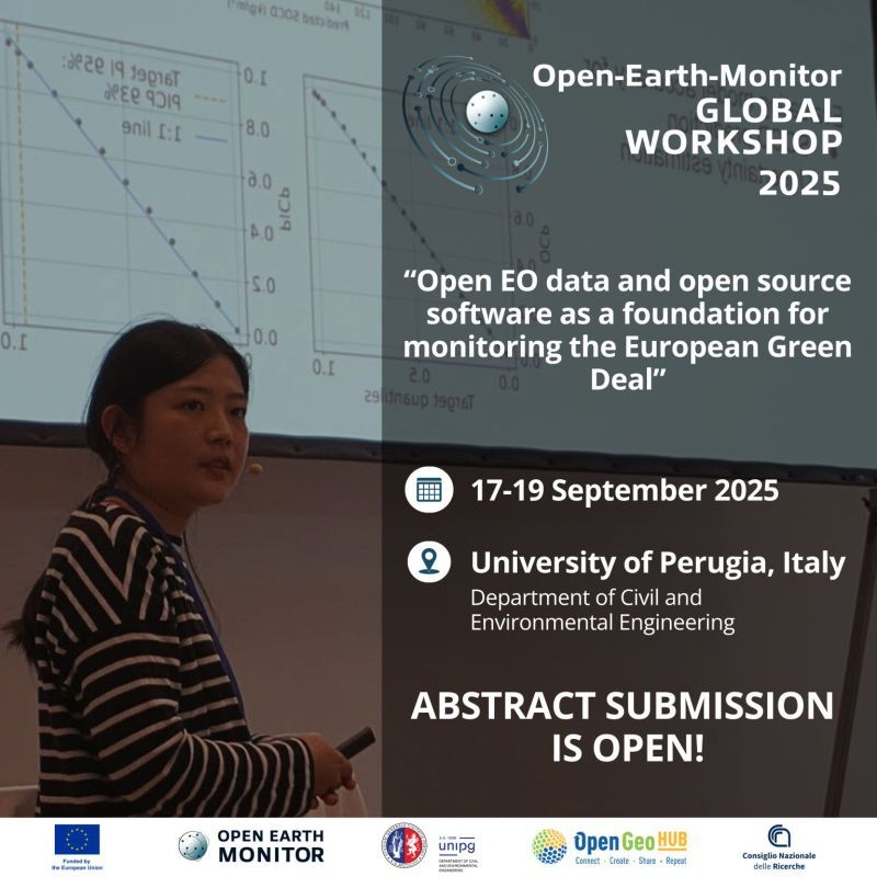
Had an excellent conf at Perugia @openearthmonitor.bsky.social Global Workshop 2025. If you missed it, we video-recorded 📼 talks: www.youtube.com/playlist?lis...
Topics covered: #OpenEO #CDSE #Copernicus #deforestation monitoring... 🚧 some videos (3-4) unfortunately with poorer quality
Topics covered: #OpenEO #CDSE #Copernicus #deforestation monitoring... 🚧 some videos (3-4) unfortunately with poorer quality

Open-Earth-Monitor Global Workshop 2025 Perugia, Italy - YouTube
The Open Earth Monitor — Global Workshop 2025 “Open EO data and open source software as a foundation for monitoring the European Green Deal”, the 4th global ...
www.youtube.com
October 1, 2025 at 11:43 AM
Had an excellent conf at Perugia @openearthmonitor.bsky.social Global Workshop 2025. If you missed it, we video-recorded 📼 talks: www.youtube.com/playlist?lis...
Topics covered: #OpenEO #CDSE #Copernicus #deforestation monitoring... 🚧 some videos (3-4) unfortunately with poorer quality
Topics covered: #OpenEO #CDSE #Copernicus #deforestation monitoring... 🚧 some videos (3-4) unfortunately with poorer quality
If you maybe missed the #EOSummerSchool2025 at WICC, video-recordings 📼 and lecture materials are now available: youtube.com/playlist?lis...
The event was organized in collaboration with EO Council (www.eo-council.nl), Netherlands Space Office (www.spaceoffice.nl/en/) and SURF (www.surf.nl/en/).
The event was organized in collaboration with EO Council (www.eo-council.nl), Netherlands Space Office (www.spaceoffice.nl/en/) and SURF (www.surf.nl/en/).
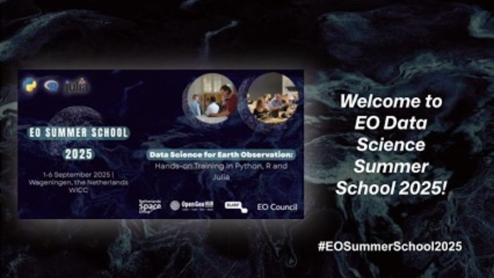
OpenGeoHub Summer School 2025 at WICC "Data Science for Earth Observation" - YouTube
Data Science for Earth Observation: Hands-on Training in Python, R and Julia Date: 1—6 September 2025 Location: Wageningen, Netherlands IMPORTANT NOTICE: Som...
youtube.com
September 26, 2025 at 11:38 AM
If you maybe missed the #EOSummerSchool2025 at WICC, video-recordings 📼 and lecture materials are now available: youtube.com/playlist?lis...
The event was organized in collaboration with EO Council (www.eo-council.nl), Netherlands Space Office (www.spaceoffice.nl/en/) and SURF (www.surf.nl/en/).
The event was organized in collaboration with EO Council (www.eo-council.nl), Netherlands Space Office (www.spaceoffice.nl/en/) and SURF (www.surf.nl/en/).
Had a privilege and pleasure to teach terra pkg (created by @roberthijmans.bsky.social et al.) and spatial sampling with R together with Alexandre Wadoux at the #EOSummerSchool2025 at WICC. You can follow the terra tutorial from here: differ.blog/p/processing...
📹: youtu.be/q9sQkg7BeAc?...
📹: youtu.be/q9sQkg7BeAc?...

Processing large rasters using terra package for R: combining tiling and time-series modeling
Processing large rasters using terra package for R: combining tiling and time-series modeling
differ.blog
September 15, 2025 at 8:53 PM
Had a privilege and pleasure to teach terra pkg (created by @roberthijmans.bsky.social et al.) and spatial sampling with R together with Alexandre Wadoux at the #EOSummerSchool2025 at WICC. You can follow the terra tutorial from here: differ.blog/p/processing...
📹: youtu.be/q9sQkg7BeAc?...
📹: youtu.be/q9sQkg7BeAc?...
We are doing a 1hr webinar on 30-m resolution global soil mapping and the new #Open #soil data kindly hosted by @geoldn.bsky.social. To register: www.eventbrite.com/e/openlandma...
📅 24 September 2025
🕐 13:00 – 14:00 (CEST)
💬 Seminar language: English
GeoLDN webinars: geo-ldn.org/events/geo-l...
📅 24 September 2025
🕐 13:00 – 14:00 (CEST)
💬 Seminar language: English
GeoLDN webinars: geo-ldn.org/events/geo-l...
OpenLandMap-soildb: global dynamic soil data at 30 m resolution
Discover detailed global soil data at a high resolution of 30 meters on OpenLandMap-soildb - all available online!
www.eventbrite.com
September 10, 2025 at 5:15 PM
We are doing a 1hr webinar on 30-m resolution global soil mapping and the new #Open #soil data kindly hosted by @geoldn.bsky.social. To register: www.eventbrite.com/e/openlandma...
📅 24 September 2025
🕐 13:00 – 14:00 (CEST)
💬 Seminar language: English
GeoLDN webinars: geo-ldn.org/events/geo-l...
📅 24 September 2025
🕐 13:00 – 14:00 (CEST)
💬 Seminar language: English
GeoLDN webinars: geo-ldn.org/events/geo-l...
Our paper now in @nature.com Scientific Data
"Global 30-m annual median vegetation height maps (2000–2022) based on ICESat-2 data and ML"
doi.org/10.1038/s415...
🌍 stac.openlandmap.org/gpw_gsvh-30m...
📱 global-pasture-watch.projects.earthengine.app/view/gsvh-30m
📰 landcarbonlab.org/insights/glo...
"Global 30-m annual median vegetation height maps (2000–2022) based on ICESat-2 data and ML"
doi.org/10.1038/s415...
🌍 stac.openlandmap.org/gpw_gsvh-30m...
📱 global-pasture-watch.projects.earthengine.app/view/gsvh-30m
📰 landcarbonlab.org/insights/glo...

Global 30-m annual median vegetation height maps (2000–2022) based on ICESat-2 data and Machine Learning - Scientific Data
Scientific Data - Global 30-m annual median vegetation height maps (2000–2022) based on ICESat-2 data and Machine Learning
doi.org
September 7, 2025 at 4:07 PM
Our paper now in @nature.com Scientific Data
"Global 30-m annual median vegetation height maps (2000–2022) based on ICESat-2 data and ML"
doi.org/10.1038/s415...
🌍 stac.openlandmap.org/gpw_gsvh-30m...
📱 global-pasture-watch.projects.earthengine.app/view/gsvh-30m
📰 landcarbonlab.org/insights/glo...
"Global 30-m annual median vegetation height maps (2000–2022) based on ICESat-2 data and ML"
doi.org/10.1038/s415...
🌍 stac.openlandmap.org/gpw_gsvh-30m...
📱 global-pasture-watch.projects.earthengine.app/view/gsvh-30m
📰 landcarbonlab.org/insights/glo...
The blog post about the poll we did today "15 practical questions about the present and future of the EO data science" is now available: differ.blog/p/quo-vadis-...
See if something surprises you in these results.
#EOSummerSchool2025
@opengeohub.bsky.social @openearthmonitor.bsky.social
See if something surprises you in these results.
#EOSummerSchool2025
@opengeohub.bsky.social @openearthmonitor.bsky.social

Quo vadis EO data science? 15 practical questions about the present and future of the field
Quo vadis EO data science? 15 practical questions about the present and future of the field
differ.blog
September 1, 2025 at 8:32 PM
The blog post about the poll we did today "15 practical questions about the present and future of the EO data science" is now available: differ.blog/p/quo-vadis-...
See if something surprises you in these results.
#EOSummerSchool2025
@opengeohub.bsky.social @openearthmonitor.bsky.social
See if something surprises you in these results.
#EOSummerSchool2025
@opengeohub.bsky.social @openearthmonitor.bsky.social
Today we launched our new Horizon Europe project OGCR (Open Geospatial Carbon Registry), read more about what is the project about and what you can expect here: differ.blog/p/building-a...
Funded by @ec.europa.eu HORIZON Europe programme cordis.europa.eu/project/id/1...
#OGCR #EUGreenDeal
Funded by @ec.europa.eu HORIZON Europe programme cordis.europa.eu/project/id/1...
#OGCR #EUGreenDeal

Building an open source foundation for the EU Carbon Registry
Intergenerational Open Geospatial Carbon Registry - Open-Source Tools for Connecting EU Agricultural Policies (CAP) and Carbon Removals and Carbon Farming (CRCF) Regulation to national inventories and...
differ.blog
August 25, 2025 at 12:12 PM
Today we launched our new Horizon Europe project OGCR (Open Geospatial Carbon Registry), read more about what is the project about and what you can expect here: differ.blog/p/building-a...
Funded by @ec.europa.eu HORIZON Europe programme cordis.europa.eu/project/id/1...
#OGCR #EUGreenDeal
Funded by @ec.europa.eu HORIZON Europe programme cordis.europa.eu/project/id/1...
#OGCR #EUGreenDeal
The global bimonthly 30m GPP product (2000-2024) is now ready for use (landcarbonlab.org/insights/glo...); available on GEE, STAC... so proud of the @opengeohub.bsky.social and @worldresources.bsky.social & colleagues!
📝 doi.org/10.7717/peer...
🖥️ stac.openlandmap.org/gpw_ugpp.dai...
📝 doi.org/10.7717/peer...
🖥️ stac.openlandmap.org/gpw_ugpp.dai...

Tracking the Health of Earth’s Ecosystems with New Global Productivity Data
Gross primary productivity (GPP) is a key indicator of ecosystem health. New data from Land & Carbon Lab provides the first global, higher resolution GPP data.
landcarbonlab.org
August 22, 2025 at 8:49 AM
The global bimonthly 30m GPP product (2000-2024) is now ready for use (landcarbonlab.org/insights/glo...); available on GEE, STAC... so proud of the @opengeohub.bsky.social and @worldresources.bsky.social & colleagues!
📝 doi.org/10.7717/peer...
🖥️ stac.openlandmap.org/gpw_ugpp.dai...
📝 doi.org/10.7717/peer...
🖥️ stac.openlandmap.org/gpw_ugpp.dai...
Registrations are closing for the Perugia Global Workshop 17-19th September, 2025 #OpenEarthMonitor project earthmonitor.org/global-works...
Reserve your spot, register now 📣 : pretix.eu/opengeohubfo...
See you in Perugia!
Reserve your spot, register now 📣 : pretix.eu/opengeohubfo...
See you in Perugia!

August 13, 2025 at 2:15 PM
Registrations are closing for the Perugia Global Workshop 17-19th September, 2025 #OpenEarthMonitor project earthmonitor.org/global-works...
Reserve your spot, register now 📣 : pretix.eu/opengeohubfo...
See you in Perugia!
Reserve your spot, register now 📣 : pretix.eu/opengeohubfo...
See you in Perugia!
Just published in @peerj.bsky.social! New 30m spatial resolution (Landsat-based) bimonthly global #Open Gross Primary Productivity (gC-per-m2-per-day) data set for 2000-2024: doi.org/10.7717/peer...
Access data from: stac.openlandmap.org/gpw_ugpp.dai... or from developers.google.com/earth-engine...
Access data from: stac.openlandmap.org/gpw_ugpp.dai... or from developers.google.com/earth-engine...
Light use efficiency (LUE) based bimonthly gross primary productivity (GPP) for global grasslands at 30 m spatial resolution (2000–2022)
The article describes production of a high spatial resolution (30 m) bimonthly light use efficiency (LUE) based gross primary productivity (GPP) data set representing grasslands for the period 2000 to...
doi.org
August 12, 2025 at 1:44 PM
Just published in @peerj.bsky.social! New 30m spatial resolution (Landsat-based) bimonthly global #Open Gross Primary Productivity (gC-per-m2-per-day) data set for 2000-2024: doi.org/10.7717/peer...
Access data from: stac.openlandmap.org/gpw_ugpp.dai... or from developers.google.com/earth-engine...
Access data from: stac.openlandmap.org/gpw_ugpp.dai... or from developers.google.com/earth-engine...
#GEDTM30 provides ensemble Digital Terrain model and some 15+ #geomorphometry variables (at 6 nested resolutions 30, 60, 120, 240, 480 and 960 m resolutions). Read more about this dataset here: doi.org/10.7717/peer...
Data access: github.com/openlandmap/...
@openearthmonitor.bsky.social
Data access: github.com/openlandmap/...
@openearthmonitor.bsky.social
GEDTM30: global ensemble digital terrain model at 30 m and derived multiscale terrain variables
Production and validation of an open global ensemble digital terrain model (GEDTM30) and derived terrain variables at 1 arc-s spacing grid ( $\sim$∼ 30 m spatial resolution) is described. Copernicus D...
doi.org
July 24, 2025 at 10:16 AM
#GEDTM30 provides ensemble Digital Terrain model and some 15+ #geomorphometry variables (at 6 nested resolutions 30, 60, 120, 240, 480 and 960 m resolutions). Read more about this dataset here: doi.org/10.7717/peer...
Data access: github.com/openlandmap/...
@openearthmonitor.bsky.social
Data access: github.com/openlandmap/...
@openearthmonitor.bsky.social
🌍 Registrations for the Open-Earth-Monitor Global Workshop 2025 @openearthmonitor.bsky.social are Now Open! Join us in Perugia, Italy, September 17–19 "where open data meets real-world solutions for environmental challenges" (earthmonitor.org/global-works...).
To register: pretix.eu/opengeohubfo...
To register: pretix.eu/opengeohubfo...
Global Workshop 2025 – Open-Earth-Monitor project
earthmonitor.org
July 15, 2025 at 4:36 PM
🌍 Registrations for the Open-Earth-Monitor Global Workshop 2025 @openearthmonitor.bsky.social are Now Open! Join us in Perugia, Italy, September 17–19 "where open data meets real-world solutions for environmental challenges" (earthmonitor.org/global-works...).
To register: pretix.eu/opengeohubfo...
To register: pretix.eu/opengeohubfo...
Senior Developer / Software Engineer wanted: #OpenSource tools for #geospatial data at @opengeohub.bsky.social
Application Deadline: 1st of Aug 2025
Possible start date: 1st of Oct 2025
Duration: 3+ years,
Job location: Doorwerth, NL
Bruto monthly salary: starting at €4,494 gross
Application Deadline: 1st of Aug 2025
Possible start date: 1st of Oct 2025
Duration: 3+ years,
Job location: Doorwerth, NL
Bruto monthly salary: starting at €4,494 gross

July 15, 2025 at 2:29 PM
Senior Developer / Software Engineer wanted: #OpenSource tools for #geospatial data at @opengeohub.bsky.social
Application Deadline: 1st of Aug 2025
Possible start date: 1st of Oct 2025
Duration: 3+ years,
Job location: Doorwerth, NL
Bruto monthly salary: starting at €4,494 gross
Application Deadline: 1st of Aug 2025
Possible start date: 1st of Oct 2025
Duration: 3+ years,
Job location: Doorwerth, NL
Bruto monthly salary: starting at €4,494 gross
So proud of the @ai4soilhealth.bsky.social team for getting this article out: doi.org/10.7717/peer... #SoilScience #NaturalResourceManagement this is (to our knowledge) first ever #OpenData dynamic soil carbon density product at fine spatial res (30-m) for EU. Explore the data via ecodatacube.eu
Spatiotemporal prediction of soil organic carbon density in Europe (2000–2022) using earth observation and machine learning
This article describes a comprehensive framework for soil organic carbon density (SOCD, kg/m3) modeling and mapping, based on spatiotemporal random forest (RF) and quantile regression forests (QRF). A...
doi.org
July 14, 2025 at 4:02 PM
So proud of the @ai4soilhealth.bsky.social team for getting this article out: doi.org/10.7717/peer... #SoilScience #NaturalResourceManagement this is (to our knowledge) first ever #OpenData dynamic soil carbon density product at fine spatial res (30-m) for EU. Explore the data via ecodatacube.eu
If you missed our @ai4soilhealth.bsky.social webinar on how to access and use Soil Health Data Cube for pan-EU (25 yrs of biophysical indices at 30m to 10m res; includes SOC density & land degradation indices) you can watch it here:
m.youtube.com/watch?v=DRT1... paper: doi.org/10.5194/essd...
m.youtube.com/watch?v=DRT1... paper: doi.org/10.5194/essd...

Unlocking the power of open data for soil health
YouTube video by AI4SoilHealth
m.youtube.com
July 11, 2025 at 7:41 AM
If you missed our @ai4soilhealth.bsky.social webinar on how to access and use Soil Health Data Cube for pan-EU (25 yrs of biophysical indices at 30m to 10m res; includes SOC density & land degradation indices) you can watch it here:
m.youtube.com/watch?v=DRT1... paper: doi.org/10.5194/essd...
m.youtube.com/watch?v=DRT1... paper: doi.org/10.5194/essd...
We are looking for a Computer scientist 🤖 High Performance Computing for EO data. Come and work for @opengeohub.bsky.social join our high profile projects @openearthmonitor.bsky.social Open Geospatial Carbon Reg, @landcarbonlab.bsky.social ... Apply before 01-Aug: opengeohub.org/jobs/compute...
Computer scientist: High Performance Computing for Earth Observation data - OpenGeoHub Foundation: Connect | Create | Share | Repeat
Come to OpenGeoHub and help us improve, optimize and extend HPC infrastructures for Machine Learning so we can contribute together to the global good.
opengeohub.org
July 10, 2025 at 8:45 AM
We are looking for a Computer scientist 🤖 High Performance Computing for EO data. Come and work for @opengeohub.bsky.social join our high profile projects @openearthmonitor.bsky.social Open Geospatial Carbon Reg, @landcarbonlab.bsky.social ... Apply before 01-Aug: opengeohub.org/jobs/compute...
The v1 of the 30 m resolution global soil carbon density, SOC content, pH, texture fractions, bulk density and soil types (USDA subgroups) now out; soil carbon and soil pH are mapped as dynamic soil variables for 5yr intervals. Preprint: doi.org/10.5194/essd...
Data: github.com/openlandmap/...
Data: github.com/openlandmap/...
OpenLandMap-soildb: global soil information at 30 m spatial resolution for 2000–2022+ based on spatiotemporal Machine Learning and harmonized legacy soil samples and observations
Abstract. There is increasing interest in global dynamic soil information with changes in soil properties mapped over time and at high spatial resolution. Thanks to long-term, multi-temporal, and fine...
doi.org
June 24, 2025 at 8:30 PM
The v1 of the 30 m resolution global soil carbon density, SOC content, pH, texture fractions, bulk density and soil types (USDA subgroups) now out; soil carbon and soil pH are mapped as dynamic soil variables for 5yr intervals. Preprint: doi.org/10.5194/essd...
Data: github.com/openlandmap/...
Data: github.com/openlandmap/...
📢 Researchers wanted!
- PhD candidate: Hybrid geospatial modeling of carbon fluxes and associated uncertainty for scenario testing (opengeohub.org/jobs/researc... with Uni of Utrecht),
- Research assistant: modeling land use & land cover dynamics using ML & AI (opengeohub.org/jobs/researc...),
- PhD candidate: Hybrid geospatial modeling of carbon fluxes and associated uncertainty for scenario testing (opengeohub.org/jobs/researc... with Uni of Utrecht),
- Research assistant: modeling land use & land cover dynamics using ML & AI (opengeohub.org/jobs/researc...),

June 24, 2025 at 9:10 AM
📢 Researchers wanted!
- PhD candidate: Hybrid geospatial modeling of carbon fluxes and associated uncertainty for scenario testing (opengeohub.org/jobs/researc... with Uni of Utrecht),
- Research assistant: modeling land use & land cover dynamics using ML & AI (opengeohub.org/jobs/researc...),
- PhD candidate: Hybrid geospatial modeling of carbon fluxes and associated uncertainty for scenario testing (opengeohub.org/jobs/researc... with Uni of Utrecht),
- Research assistant: modeling land use & land cover dynamics using ML & AI (opengeohub.org/jobs/researc...),
Say goodbye to human-readable EO images. Computers do not need to look and think as humans to get work done. Accuracy and efficiency is all you need. Google EE team now makes 10m ARD (annual starting from 2020) synthetic bands / deep features (64 in total): developers.google.com/earth-engine...
Satellite Embedding V1 | Earth Engine Data Catalog | Google for Developers
The Google Satellite Embedding dataset is a global, analysis-ready collection of learned geospatial embeddings. Each 10-meter pixel in this dataset is a 64-dimensional representation, or "embeddi...
developers.google.com
June 23, 2025 at 9:50 AM
Say goodbye to human-readable EO images. Computers do not need to look and think as humans to get work done. Accuracy and efficiency is all you need. Google EE team now makes 10m ARD (annual starting from 2020) synthetic bands / deep features (64 in total): developers.google.com/earth-engine...

We are excited to come to #LPS25 and connect with EO / remote sensing data scientists (apparently over 6500 participants are expected!) next week. Well done @esa.int !
Are you also coming to Vienna next week and would like to connect? Please bookmark and visit us: docs.google.com/document/d/1...
Are you also coming to Vienna next week and would like to connect? Please bookmark and visit us: docs.google.com/document/d/1...

ESA LPS 2025: Living Planet Symposium Vienna
OpenGeoHub talks and workshops at LPS 2025 Project homepages: https://EarthMonitor.org, Global Pasture Watch Sunday - 22.06.2025 17:00: D.03.11 TUTORIAL - Satellite Image Time Series Analysis on Eart...
docs.google.com
June 21, 2025 at 12:01 PM
We are excited to come to #LPS25 and connect with EO / remote sensing data scientists (apparently over 6500 participants are expected!) next week. Well done @esa.int !
Are you also coming to Vienna next week and would like to connect? Please bookmark and visit us: docs.google.com/document/d/1...
Are you also coming to Vienna next week and would like to connect? Please bookmark and visit us: docs.google.com/document/d/1...
📢 Call for Abstracts for @openearthmonitor.bsky.social 𝗚𝗹𝗼𝗯𝗮𝗹 𝗪𝗼𝗿𝗸𝘀𝗵𝗼𝗽 𝟮𝟬𝟮𝟱 𝗶𝘀 𝗡𝗢𝗪 𝗢𝗣𝗘𝗡!
🌍 “Open EO data and open source software as a foundation for monitoring the European Green Deal”,
🗓️ Date: 17-19 September 2025
📍 Location: University of Perugia, Italy
👉 opengeohub.org/summer-schoo...
🌍 “Open EO data and open source software as a foundation for monitoring the European Green Deal”,
🗓️ Date: 17-19 September 2025
📍 Location: University of Perugia, Italy
👉 opengeohub.org/summer-schoo...
June 10, 2025 at 12:04 PM
📢 Call for Abstracts for @openearthmonitor.bsky.social 𝗚𝗹𝗼𝗯𝗮𝗹 𝗪𝗼𝗿𝗸𝘀𝗵𝗼𝗽 𝟮𝟬𝟮𝟱 𝗶𝘀 𝗡𝗢𝗪 𝗢𝗣𝗘𝗡!
🌍 “Open EO data and open source software as a foundation for monitoring the European Green Deal”,
🗓️ Date: 17-19 September 2025
📍 Location: University of Perugia, Italy
👉 opengeohub.org/summer-schoo...
🌍 “Open EO data and open source software as a foundation for monitoring the European Green Deal”,
🗓️ Date: 17-19 September 2025
📍 Location: University of Perugia, Italy
👉 opengeohub.org/summer-schoo...
Reposted by Tom Hengl

🚀 EO-Summer School 2025 registrations are open until July 1!
Join us Sept 1–6 in Wageningen, NL for workshops, demos, hackathons & networking.
Co-hosted by OpenGeoHub, NSO, EO Council & SURF. Secure your spot now! pretix.eu/opengeohubfo...
🌐Learn more: opengeohub.org/summer-schoo...
Join us Sept 1–6 in Wageningen, NL for workshops, demos, hackathons & networking.
Co-hosted by OpenGeoHub, NSO, EO Council & SURF. Secure your spot now! pretix.eu/opengeohubfo...
🌐Learn more: opengeohub.org/summer-schoo...

May 30, 2025 at 7:13 AM
🚀 EO-Summer School 2025 registrations are open until July 1!
Join us Sept 1–6 in Wageningen, NL for workshops, demos, hackathons & networking.
Co-hosted by OpenGeoHub, NSO, EO Council & SURF. Secure your spot now! pretix.eu/opengeohubfo...
🌐Learn more: opengeohub.org/summer-schoo...
Join us Sept 1–6 in Wageningen, NL for workshops, demos, hackathons & networking.
Co-hosted by OpenGeoHub, NSO, EO Council & SURF. Secure your spot now! pretix.eu/opengeohubfo...
🌐Learn more: opengeohub.org/summer-schoo...