


Tennessee Valley Weather
@tnvalleyweather.com
Providing daily forecast updates & to-the-minute severe weather info for Southern Middle Tennessee, Northwest Alabama, and Northeast Mississippi.
www.tnvalleyweather.com #tnvalleyweather #alwx #tnwx #mswx
www.tnvalleyweather.com #tnvalleyweather #alwx #tnwx #mswx
Strong storms moved through Thursday night, producing wind gusts near 45 mph that toppled a large tree in the New Prospect community. The tree fell onto a home on Jill Drive, causing a partial collapse of the residence. Thankfully, no injuries were reported.


December 19, 2025 at 8:42 AM
Strong storms moved through Thursday night, producing wind gusts near 45 mph that toppled a large tree in the New Prospect community. The tree fell onto a home on Jill Drive, causing a partial collapse of the residence. Thankfully, no injuries were reported.
🚀 Tennessee Valley Weather just became the first weather team in space! (Well… sort of.)
Thanks to CrunchLabs and their “SAT GUS” mission, our team photo was transmitted to an orbiting satellite, displayed on a screen and photographed for an official #SpaceSelfie.
#tnvalleyweather #weather
Thanks to CrunchLabs and their “SAT GUS” mission, our team photo was transmitted to an orbiting satellite, displayed on a screen and photographed for an official #SpaceSelfie.
#tnvalleyweather #weather

November 12, 2025 at 10:12 AM
🚀 Tennessee Valley Weather just became the first weather team in space! (Well… sort of.)
Thanks to CrunchLabs and their “SAT GUS” mission, our team photo was transmitted to an orbiting satellite, displayed on a screen and photographed for an official #SpaceSelfie.
#tnvalleyweather #weather
Thanks to CrunchLabs and their “SAT GUS” mission, our team photo was transmitted to an orbiting satellite, displayed on a screen and photographed for an official #SpaceSelfie.
#tnvalleyweather #weather
💫 Did you see it?
Our Minor Hill SkyCam, part of the Arctic Air SkyCam Network, captured a brilliant meteor streaking through the atmosphere early this morning! 🌠
The meteor was visible across much of the Tennessee Valley region, lighting up the sky with a flash of cosmic beauty.
Our Minor Hill SkyCam, part of the Arctic Air SkyCam Network, captured a brilliant meteor streaking through the atmosphere early this morning! 🌠
The meteor was visible across much of the Tennessee Valley region, lighting up the sky with a flash of cosmic beauty.
November 6, 2025 at 3:10 PM
💫 Did you see it?
Our Minor Hill SkyCam, part of the Arctic Air SkyCam Network, captured a brilliant meteor streaking through the atmosphere early this morning! 🌠
The meteor was visible across much of the Tennessee Valley region, lighting up the sky with a flash of cosmic beauty.
Our Minor Hill SkyCam, part of the Arctic Air SkyCam Network, captured a brilliant meteor streaking through the atmosphere early this morning! 🌠
The meteor was visible across much of the Tennessee Valley region, lighting up the sky with a flash of cosmic beauty.
🚨 Flash Flooding in southern Maury County 🚨
Flooding remains a major issue across southern Maury County this morning. This video shows what many roads look like: covered in fast-moving water.
⚠️ Please stay safe: Turn Around, Don’t Drown!
#tnvalleyweather #tnwx
Flooding remains a major issue across southern Maury County this morning. This video shows what many roads look like: covered in fast-moving water.
⚠️ Please stay safe: Turn Around, Don’t Drown!
#tnvalleyweather #tnwx
September 23, 2025 at 3:15 PM
🚨 Flash Flooding in southern Maury County 🚨
Flooding remains a major issue across southern Maury County this morning. This video shows what many roads look like: covered in fast-moving water.
⚠️ Please stay safe: Turn Around, Don’t Drown!
#tnvalleyweather #tnwx
Flooding remains a major issue across southern Maury County this morning. This video shows what many roads look like: covered in fast-moving water.
⚠️ Please stay safe: Turn Around, Don’t Drown!
#tnvalleyweather #tnwx
STORM DAMAGE: A tree has fallen onto power lines near the intersection of Rascal Town and Lou John Roads in southern Lawrence County, TN. Over 120 homes are currently without power. Crews are responding. #tnvalleyweather #tnwx

June 28, 2025 at 11:46 PM
STORM DAMAGE: A tree has fallen onto power lines near the intersection of Rascal Town and Lou John Roads in southern Lawrence County, TN. Over 120 homes are currently without power. Crews are responding. #tnvalleyweather #tnwx
Been outside today? Here’s your Sunday afternoon outlook in one picture. #tnvalleyweather #tnwx #weather

June 22, 2025 at 7:50 PM
Been outside today? Here’s your Sunday afternoon outlook in one picture. #tnvalleyweather #tnwx #weather
Check out this approaching storm from the Giles County Emergency Services Fort Hill Camera, part of our Arctic Air Heating and Air Conditioning SkyCam Network. This storm contains spots of heavy rain and gusty winds but is below severe criteria at this time. #tnvalleyweather #tnwx

May 3, 2025 at 10:59 PM
Check out this approaching storm from the Giles County Emergency Services Fort Hill Camera, part of our Arctic Air Heating and Air Conditioning SkyCam Network. This storm contains spots of heavy rain and gusty winds but is below severe criteria at this time. #tnvalleyweather #tnwx
Wavy clouds have been spotted this afternoon. They are called Asperitas Clouds and are a distinctive, but rare formation that looks like rippling waves. They are formed by rising air interacting with shearing wind which is believed to created the wave effect.
#tnvalleyweather #tnwx
#tnvalleyweather #tnwx


March 7, 2025 at 10:43 PM
Wavy clouds have been spotted this afternoon. They are called Asperitas Clouds and are a distinctive, but rare formation that looks like rippling waves. They are formed by rising air interacting with shearing wind which is believed to created the wave effect.
#tnvalleyweather #tnwx
#tnvalleyweather #tnwx
UNDER WATER - Several areas in Lawrence County, TN are becoming concerning due to flooding issues. Pictured is the low water bridge on North Beasley Road just north of Lawrenceburg. Use extreme caution if traveling in flood prone areas over the next few days. #tnvalleyweather #tnwx

February 11, 2025 at 6:43 PM
UNDER WATER - Several areas in Lawrence County, TN are becoming concerning due to flooding issues. Pictured is the low water bridge on North Beasley Road just north of Lawrenceburg. Use extreme caution if traveling in flood prone areas over the next few days. #tnvalleyweather #tnwx
FROZEN SOLID - Hayden chunked a rock into the pond behind our office building this morning. Listen for the “thud” on on the ice. #tnvalleyweather #tnwx
January 21, 2025 at 5:43 PM
FROZEN SOLID - Hayden chunked a rock into the pond behind our office building this morning. Listen for the “thud” on on the ice. #tnvalleyweather #tnwx
Thank you to our friend Landon for this picture of the sunrise over the Rocket City at Huntsville International Airport. May today bring blessings and joy to you wherever you are this Friday. #tnvalleyweather #alwx

January 17, 2025 at 12:30 PM
Thank you to our friend Landon for this picture of the sunrise over the Rocket City at Huntsville International Airport. May today bring blessings and joy to you wherever you are this Friday. #tnvalleyweather #alwx
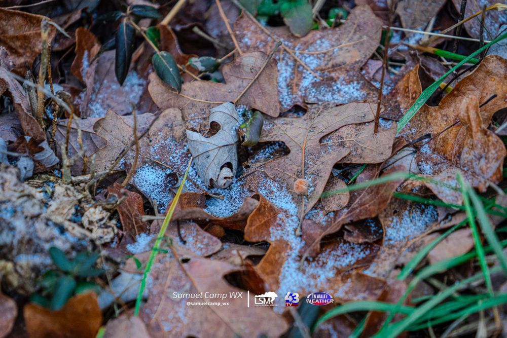
This is all the snow we could find at the studios in Lawrenceburg this afternoon. If you got some snow too, show us in the comments!
#alwx #tnwx #mswx #tnvalleyweather
#alwx #tnwx #mswx #tnvalleyweather
January 6, 2025 at 8:00 PM
This is all the snow we could find at the studios in Lawrenceburg this afternoon. If you got some snow too, show us in the comments!
#alwx #tnwx #mswx #tnvalleyweather
#alwx #tnwx #mswx #tnvalleyweather
Breaking News: National Weather Service Huntsville has determined that an EF-1 tornado with sustained winds of 100 mph struck a path through central Athens, Alabama overnight. The twister severely damaged the community's historic downtown area. #tnvalleyweather #alwx

December 29, 2024 at 8:45 PM
Breaking News: National Weather Service Huntsville has determined that an EF-1 tornado with sustained winds of 100 mph struck a path through central Athens, Alabama overnight. The twister severely damaged the community's historic downtown area. #tnvalleyweather #alwx
With the threat for severe weather in our region, we will be LIVE on all platforms with an update on the situation at 5 PM and again at 9 PM. Remember to download our mobile and smart TV apps. Our live channel is always streaming on YouTube. For links to download, visit www.tnvalleyweather.com

December 28, 2024 at 8:53 PM
With the threat for severe weather in our region, we will be LIVE on all platforms with an update on the situation at 5 PM and again at 9 PM. Remember to download our mobile and smart TV apps. Our live channel is always streaming on YouTube. For links to download, visit www.tnvalleyweather.com
We continue to watch the potential for strong storms SATURDAY afternoon into the overnight, from around 3-4pm on through midnight or so. Higher threat is to our south, but we can't rule out one or two storms with 50+ mph winds or a tornado.
#tnvalleyweather #tnwx #alwx #mswx
#tnvalleyweather #tnwx #alwx #mswx

December 27, 2024 at 2:51 PM
We continue to watch the potential for strong storms SATURDAY afternoon into the overnight, from around 3-4pm on through midnight or so. Higher threat is to our south, but we can't rule out one or two storms with 50+ mph winds or a tornado.
#tnvalleyweather #tnwx #alwx #mswx
#tnvalleyweather #tnwx #alwx #mswx
Storms in north MS have weakened from earlier, but they may still produce 35-45 mph gusts in parts of northwest Alabama as they move in after 10:30-11:00pm. Elsewhere, just rain and embedded lightning is expected.
#tnvalleyweather #tnwx #alwx #mswx
#tnvalleyweather #tnwx #alwx #mswx

December 17, 2024 at 3:29 AM
Storms in north MS have weakened from earlier, but they may still produce 35-45 mph gusts in parts of northwest Alabama as they move in after 10:30-11:00pm. Elsewhere, just rain and embedded lightning is expected.
#tnvalleyweather #tnwx #alwx #mswx
#tnvalleyweather #tnwx #alwx #mswx
Deep South December Tornado Outbreak – 24 Years Later
#alwx #tnvalleyweather #wxhistory
tnvalleyweather.com/index.php/20...
#alwx #tnvalleyweather #wxhistory
tnvalleyweather.com/index.php/20...

Deep South December Tornado Outbreak – 24 Years Later - Tennessee Valley Weather
Image Credit: The Tuscaloosa News On December 16, 2000, a powerful tornado outbreak of a total of 24 tornadoes struck the Southeastern United States, stretching from Mississippi to North Carolina. The...
tnvalleyweather.com
December 16, 2024 at 7:58 PM
Deep South December Tornado Outbreak – 24 Years Later
#alwx #tnvalleyweather #wxhistory
tnvalleyweather.com/index.php/20...
#alwx #tnvalleyweather #wxhistory
tnvalleyweather.com/index.php/20...
Reposted by Tennessee Valley Weather

Christmas time has arrived in Lawrenceburg, TN.
@tnvalleyweather.com
#tnvalleyweather #lawrenceburgtn #Christmas
@tnvalleyweather.com
#tnvalleyweather #lawrenceburgtn #Christmas
December 16, 2024 at 6:54 PM
Christmas time has arrived in Lawrenceburg, TN.
@tnvalleyweather.com
#tnvalleyweather #lawrenceburgtn #Christmas
@tnvalleyweather.com
#tnvalleyweather #lawrenceburgtn #Christmas
Downtown Florence is all decked out for Christmas. Show us how you decorate for the holidays in the comments.
#alwx #tnwx #mswx #tnvalleyweather #Christmas
#alwx #tnwx #mswx #tnvalleyweather #Christmas


December 13, 2024 at 9:46 PM
Downtown Florence is all decked out for Christmas. Show us how you decorate for the holidays in the comments.
#alwx #tnwx #mswx #tnvalleyweather #Christmas
#alwx #tnwx #mswx #tnvalleyweather #Christmas
One of our SkyCam Network cameras in #Lawrenceburg spotted Santa spending too much time at the local pub last night or he got run over by his own reindeer. He was back upright this morning on the job of welcoming the #Christmas season into #Tennessee. #tnvalleyweather


December 3, 2024 at 7:42 PM
One of our SkyCam Network cameras in #Lawrenceburg spotted Santa spending too much time at the local pub last night or he got run over by his own reindeer. He was back upright this morning on the job of welcoming the #Christmas season into #Tennessee. #tnvalleyweather
Flurries possible this evening. So yes, we *are* saying there's a chance.
NO accumulation or impacts expected.
#tnwx #alwx #mswx #weather #tnvalleyweather tnvalleyweather.com/index.php/20...
NO accumulation or impacts expected.
#tnwx #alwx #mswx #weather #tnvalleyweather tnvalleyweather.com/index.php/20...

A few flurries tonight. No accumulation or impacts expected. Cold this week with a few rain chances. - Tennessee Valley Weather
Yes, you're probably already gawking over the word "flurries" from the headline as you clicked into this blog post. Don't also miss the "no impacts" part of the headline! Late this afternoon moisture ...
tnvalleyweather.com
December 2, 2024 at 7:08 PM
Flurries possible this evening. So yes, we *are* saying there's a chance.
NO accumulation or impacts expected.
#tnwx #alwx #mswx #weather #tnvalleyweather tnvalleyweather.com/index.php/20...
NO accumulation or impacts expected.
#tnwx #alwx #mswx #weather #tnvalleyweather tnvalleyweather.com/index.php/20...
Happy Thanksgiving everyone!

November 28, 2024 at 4:44 PM
Happy Thanksgiving everyone!
Reposted by Tennessee Valley Weather

All sorts of helicopter/plane activity today on the X-band here in S TN. Composite of the last 10 mins beautifully shows aircraft tracks #tnwx

November 27, 2024 at 8:34 PM
All sorts of helicopter/plane activity today on the X-band here in S TN. Composite of the last 10 mins beautifully shows aircraft tracks #tnwx
It's a busy week ahead in terms of the forecast. Two cold fronts will greatly impact our weather in the Tennessee Valley, from temperatures to rain & storms. New details here!
tnvalleyweather.com/index.php/2024…#tnwxw#alwxw#mswxw#weathere#tnvalleyweatherer
tnvalleyweather.com/index.php/2024…#tnwxw#alwxw#mswxw#weathere#tnvalleyweatherer
https://tnvalleyweather.com/index.php/2024…
November 25, 2024 at 7:57 PM
It's a busy week ahead in terms of the forecast. Two cold fronts will greatly impact our weather in the Tennessee Valley, from temperatures to rain & storms. New details here!
tnvalleyweather.com/index.php/2024…#tnwxw#alwxw#mswxw#weathere#tnvalleyweatherer
tnvalleyweather.com/index.php/2024…#tnwxw#alwxw#mswxw#weathere#tnvalleyweatherer