Tony Mainolfi
banner
tmainolfiwesh.bsky.social
Tony Mainolfi
@tmainolfiwesh.bsky.social
Chief Meteorologist at @WESH2 News in Orlando, Florida | SUNY Albany Meteorology | Husband & Father | Covering Central Florida Hurricanes since 2005
A freeze warning is in place for tonight for #Marion county as temperatures are expected to drop below freezing. Remember to bring your pets in tonight and cover up any plants with a breathable cloth. Stay with #weshwx for updates.
November 10, 2025 at 11:56 PM
RECORD COLD is on the way to Central #florida! Many cities will break or be near record cold lows waking up Tuesday morning! Get those jackets ready to go! #weshwx #winter #cold
November 10, 2025 at 11:53 PM
COLD WEATHER ADVISORY: Has been issued for all of Central #florida from 2AM-9AM Tuesday as wind chill values will be in the 25-35 range! Remember to bring those pets in and dress those little ones warmly tomorrow morning. #weshwx
November 10, 2025 at 11:52 PM
RECORD COLD is on the way to Central #florida! Many cities will break or be near record cold lows waking up Tuesday morning! Get those jackets ready to go! #weshwx #winter #cold
November 10, 2025 at 10:42 PM
A freeze warning is in place for tonight for #Marion county as temperatures are expected to drop below freezing. Remember to bring your pets in tonight and cover up any plants with a breathable cloth. Stay with #weshwx for updates.
November 10, 2025 at 3:18 PM
COLD WEATHER ADVISORY: Has been issued for all of Central #florida from 2AM-9AM Tuesday as wind chill values will be in the 25-35 range! Remember to bring those pets in and dress those little ones warmly tomorrow morning. #weshwx
November 10, 2025 at 3:03 PM
RECORD COLD is on the way to Central #florida! Many cities will break or be near record cold lows waking up Tuesday morning! Get those jackets ready to go! #weshwx #winter #cold
November 10, 2025 at 2:51 PM
RECORD COLD is on the way to Central #florida! Many cities will break or be near record cold lows waking up Tuesday morning! Get those jackets ready to go! #weshwx #winter #cold
November 10, 2025 at 3:17 AM
Here's a look at some of the colder temperatures headedour way over thenext few days. Stay with #weshwx for updates.
November 10, 2025 at 12:08 AM
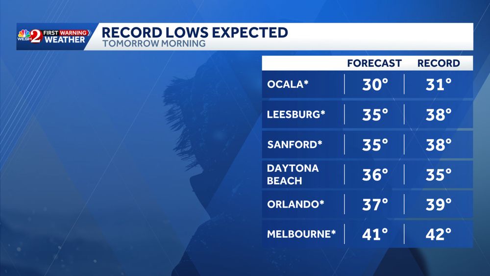
Record cold is on the way! Many cities will break or be near record cold lows waking up Tuesday morning folks! Get those jackets ready to go! #weshwx
November 9, 2025 at 10:17 PM
A FEEZE WATCH has been posted for parts of #Marion county from Monday night into Tuesday morning as lows are expected to drop to or below freezing. Here's what we are expecting right now across the county. Stay with #weshwx for updates.
November 9, 2025 at 9:44 PM
Here's a look at the frost and freeze potential for Tuesday and Wednesday folks. I'll have a new update this evening. Stay with #weshwx for updates.
November 9, 2025 at 3:49 PM
Impact weather possible from 2-8 pm today folks. Stay with #weshwx for updates.
November 9, 2025 at 1:29 PM
The coldest air of the season is on the way Tuesday morning folks. Here’s an update on the chill headed to Central #florida
November 9, 2025 at 1:08 PM
Tuesday morning wind chills will be in the upper 20s and 30s across all of Central #florida. Here's a look what we are expecting + the criteria for when a wind chill advisory is issued. Stay with #weshwx for updates.
November 8, 2025 at 11:00 PM
COLD WEATHER UPDATE: Things are still on track for the coldest air of the season to arrive Tuesday morning which will set the stage for Central #florida to see it's first frost in many areas. Stay with #weshwx for updates.
November 8, 2025 at 10:30 PM
IMPACT WEATHER: There will be a small window of opportunity for strong to severe storms to develop Sunday afternoon across Central #florida. The primary concern will be damaging winds but we will also be the risk for hail. Stay with #weshwx for updates.
November 8, 2025 at 10:00 PM
IMPACT WEATHER: There will be a small window of opportunity for strong to severe storms to develop Sunday afternoon across Central #florida. The primary concern will be damaging winds but we will also be the risk for hail. Stay with #weshwx for updates.
November 8, 2025 at 2:39 PM
Tuesday morning wind chills will be in the upper 20s and 30s across all of Central #florida. Here's a look what we are expecting + the criteria for when a wind chill advisory is issued. Stay with #weshwx for updates.
November 8, 2025 at 2:27 PM
COLD WEATHER UPDATE: Things are still on track for the coldest air of the season to arrive Tuesday morning which will set the stage for Central #florida to see it's first frost in many areas. Stay with #weshwx for updates.
November 8, 2025 at 2:23 PM
The COLDEST air of the season will arrive next Tuesday morning across #florida. Here's the very latest on what to expect. Temperatures will be in the 30s and 40s but the #Windchills will be in the 20s across #Marion county. Stay with #weshwx for updates. #Frigid #winter
November 8, 2025 at 4:37 AM
As a strong cold front pushes into Florida late Sunday and collides with some very warm air and a possible east coast seas breeze, we could see some strong to severe storms work. Stay with #weshwx for updates.
November 8, 2025 at 3:14 AM
We'll be going from near record heat this weekend with the chance for strong to severe storms Sunday TO record cold and wind chills in the 20s and 30s + some frost. #weshwx
November 7, 2025 at 11:43 PM
A strong cold front will arrive late Sunday afternoon and may bring a few strong to severe storms across Central #florida. Stay with #weshwx for updates.
November 7, 2025 at 9:47 PM
Near record heat is expected Saturday befoe a few showers and a cold front arrive Sunday into Monday morning bringing the chance for somerecord cold weather!
November 7, 2025 at 6:30 PM