


sq7ro
@sq7ro.bsky.social
Radio / satellites / computers / electronics / astrophoto
MetOp SG-A1 3MI @ 09:33UTC X-band
Animation from 3MI instrument, 22 wavelength channels
Animation from 3MI instrument, 22 wavelength channels
November 11, 2025 at 3:12 PM
MetOp SG-A1 3MI @ 09:33UTC X-band
Animation from 3MI instrument, 22 wavelength channels
Animation from 3MI instrument, 22 wavelength channels
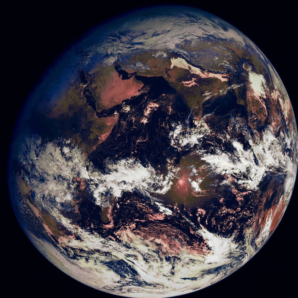
MetOp-SG-A1 METImage @ 09:25UTC X-band @ 100Msps
First METImage instrument images from new MetOp sat. True color composite.
First METImage instrument images from new MetOp sat. True color composite.

November 7, 2025 at 10:47 AM
MetOp-SG-A1 METImage @ 09:25UTC X-band @ 100Msps
First METImage instrument images from new MetOp sat. True color composite.
First METImage instrument images from new MetOp sat. True color composite.
ARKTIKA-M2 RDAS @ 19:15UTC
View on North Hemispehere from Polar region monitoring satellite. Crop on Cat.2 hurricane Gabrielle over Atlantic Ocean
View on North Hemispehere from Polar region monitoring satellite. Crop on Cat.2 hurricane Gabrielle over Atlantic Ocean


September 24, 2025 at 8:10 PM
ARKTIKA-M2 RDAS @ 19:15UTC
View on North Hemispehere from Polar region monitoring satellite. Crop on Cat.2 hurricane Gabrielle over Atlantic Ocean
View on North Hemispehere from Polar region monitoring satellite. Crop on Cat.2 hurricane Gabrielle over Atlantic Ocean
ARKTIKA-MN2 RDAS @ 20:15UTC
Only channel 2 partially usable, it looks like imagers are shifted
Only channel 2 partially usable, it looks like imagers are shifted


September 3, 2025 at 9:28 PM
ARKTIKA-MN2 RDAS @ 20:15UTC
Only channel 2 partially usable, it looks like imagers are shifted
Only channel 2 partially usable, it looks like imagers are shifted
FY-3D MERSI @ 14:20UTC X-band
West pass at max 25deg, RFNM+Satdump
West pass at max 25deg, RFNM+Satdump

September 3, 2025 at 3:27 PM
FY-3D MERSI @ 14:20UTC X-band
West pass at max 25deg, RFNM+Satdump
West pass at max 25deg, RFNM+Satdump
MetOp-SGA1 MWS @ 10:20UTC X-band
First image decoded from new MetOp sat. RFNM + Satdump verywip
First image decoded from new MetOp sat. RFNM + Satdump verywip

September 2, 2025 at 2:07 PM
MetOp-SGA1 MWS @ 10:20UTC X-band
First image decoded from new MetOp sat. RFNM + Satdump verywip
First image decoded from new MetOp sat. RFNM + Satdump verywip
METEOR MN2_4 KMSS @ 14:25UTC X-band
West pass over EU, crop 100% Monte Argentario and San Bartolomeo. RFNM + Satdump
West pass over EU, crop 100% Monte Argentario and San Bartolomeo. RFNM + Satdump


September 1, 2025 at 9:48 PM
METEOR MN2_4 KMSS @ 14:25UTC X-band
West pass over EU, crop 100% Monte Argentario and San Bartolomeo. RFNM + Satdump
West pass over EU, crop 100% Monte Argentario and San Bartolomeo. RFNM + Satdump
AQUA MODIS @ 11:32UTC X-band
Max elev 26deg, RFNM + Satdump
Max elev 26deg, RFNM + Satdump

September 1, 2025 at 2:24 PM
AQUA MODIS @ 11:32UTC X-band
Max elev 26deg, RFNM + Satdump
Max elev 26deg, RFNM + Satdump
First test from MetOp SGA-1 X-band

August 31, 2025 at 10:22 AM
First test from MetOp SGA-1 X-band
METEOR-MN2_4 KMSS @ 13:45UTC X-band
331 composite, two imagers merged. Bladerf @ 85Msps.
Crop on Italy Pad River and Sicily Mt Etna
331 composite, two imagers merged. Bladerf @ 85Msps.
Crop on Italy Pad River and Sicily Mt Etna


June 5, 2025 at 4:25 PM
METEOR-MN2_4 KMSS @ 13:45UTC X-band
331 composite, two imagers merged. Bladerf @ 85Msps.
Crop on Italy Pad River and Sicily Mt Etna
331 composite, two imagers merged. Bladerf @ 85Msps.
Crop on Italy Pad River and Sicily Mt Etna
NOAA-21, FY-3D, NOAA-20 / RFNM SDR X-band
Crop on Sicily and Etna - VIS shows dust/smoke and IR channel shows lava path
Crop on Sicily and Etna - VIS shows dust/smoke and IR channel shows lava path


June 4, 2025 at 2:59 PM
NOAA-21, FY-3D, NOAA-20 / RFNM SDR X-band
Crop on Sicily and Etna - VIS shows dust/smoke and IR channel shows lava path
Crop on Sicily and Etna - VIS shows dust/smoke and IR channel shows lava path
NOAA-20/SUOMI NPP VIIRS @ 12:10/10:10UTC X-band
True color composite, east and west pass
True color composite, east and west pass


March 20, 2025 at 1:02 PM
NOAA-20/SUOMI NPP VIIRS @ 12:10/10:10UTC X-band
True color composite, east and west pass
True color composite, east and west pass
FY-3D MERSI 11:52/13:31UTC X-band
True color composite, west and east pass at ~40deg. Crop on Poland
True color composite, west and east pass at ~40deg. Crop on Poland

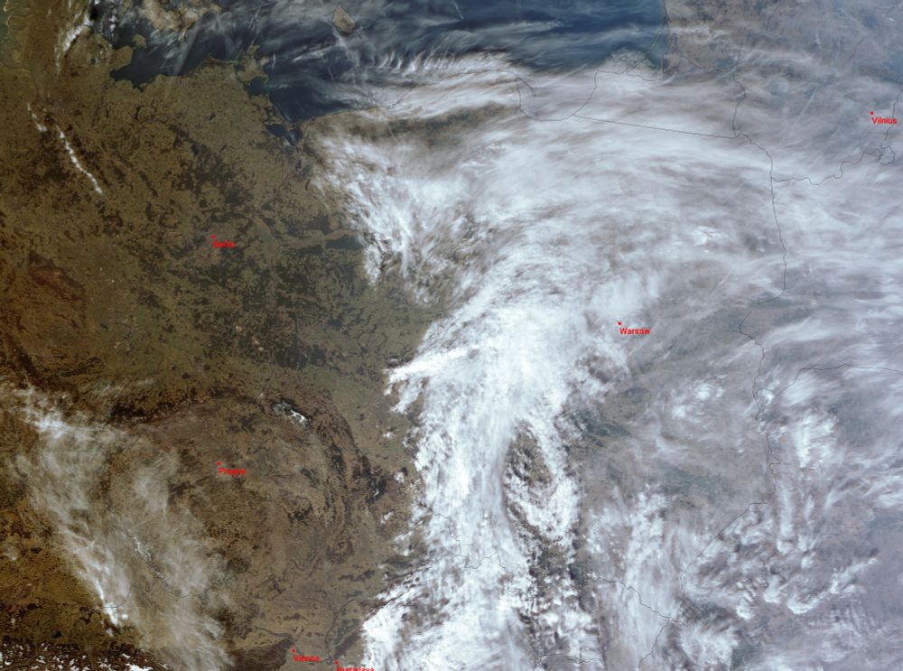

March 9, 2025 at 3:15 PM
FY-3D MERSI 11:52/13:31UTC X-band
True color composite, west and east pass at ~40deg. Crop on Poland
True color composite, west and east pass at ~40deg. Crop on Poland
SUOMI NPP VIIRS @ 12:15UTC X-band
True color composite
True color composite

March 8, 2025 at 1:03 PM
SUOMI NPP VIIRS @ 12:15UTC X-band
True color composite
True color composite


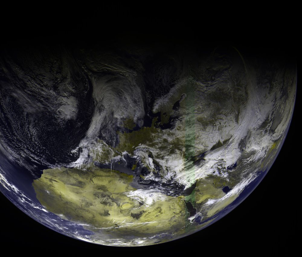
EWS-G2 GVAR @ 12:14UTC L-band
Full disk + crop on EU
Full disk + crop on EU


March 5, 2025 at 1:03 PM
EWS-G2 GVAR @ 12:14UTC L-band
Full disk + crop on EU
Full disk + crop on EU
FY-3D MERSI @ 11:45UTC X-band
221 composite, east pass
221 composite, east pass

March 4, 2025 at 3:41 PM
FY-3D MERSI @ 11:45UTC X-band
221 composite, east pass
221 composite, east pass
EWS-G2 GVAR @ 12:14UTC L-band
Full disk with view on two tropical storms Garance and Honde near Madagaskar. Crop on storm Garance with wind ~110km/h, heading Reunion Island where its predicted it will became tropical cyclone
Full disk with view on two tropical storms Garance and Honde near Madagaskar. Crop on storm Garance with wind ~110km/h, heading Reunion Island where its predicted it will became tropical cyclone


February 26, 2025 at 12:57 PM
EWS-G2 GVAR @ 12:14UTC L-band
Full disk with view on two tropical storms Garance and Honde near Madagaskar. Crop on storm Garance with wind ~110km/h, heading Reunion Island where its predicted it will became tropical cyclone
Full disk with view on two tropical storms Garance and Honde near Madagaskar. Crop on storm Garance with wind ~110km/h, heading Reunion Island where its predicted it will became tropical cyclone
NOAA-21 VIIRS @ 12:10UTC X-band
Long pass from Egypt to Iceland, true color composite
Long pass from Egypt to Iceland, true color composite

February 19, 2025 at 2:18 PM
NOAA-21 VIIRS @ 12:10UTC X-band
Long pass from Egypt to Iceland, true color composite
Long pass from Egypt to Iceland, true color composite
ARKTIKA-M2 RDAS @ 10:30UTC X-band
221 composite using latest satdump wip, strong signal ~15dB snr
221 composite using latest satdump wip, strong signal ~15dB snr
February 18, 2025 at 11:48 AM
ARKTIKA-M2 RDAS @ 10:30UTC X-band
221 composite using latest satdump wip, strong signal ~15dB snr
221 composite using latest satdump wip, strong signal ~15dB snr
ELEKTRO-L3 RDAS @ 08:30UTC X-band
221 composite with zoom on tropical storm Taliah
221 composite with zoom on tropical storm Taliah


February 17, 2025 at 10:37 AM
ELEKTRO-L3 RDAS @ 08:30UTC X-band
221 composite with zoom on tropical storm Taliah
221 composite with zoom on tropical storm Taliah
NOAA-21 DNB @ 01:37/23:55UTC X-band
Day Night band view on west and east pass, max elev 40 deg
Day Night band view on west and east pass, max elev 40 deg


February 16, 2025 at 2:09 AM
NOAA-21 DNB @ 01:37/23:55UTC X-band
Day Night band view on west and east pass, max elev 40 deg
Day Night band view on west and east pass, max elev 40 deg
AQUA MODIS @ 13:15UTC X-band
True color composite, max elev 30 deg
True color composite, max elev 30 deg

January 30, 2025 at 1:48 PM
AQUA MODIS @ 13:15UTC X-band
True color composite, max elev 30 deg
True color composite, max elev 30 deg
EWS-G2 GVAR @ 12:15UTC L-band

January 30, 2025 at 12:49 PM
EWS-G2 GVAR @ 12:15UTC L-band
ARKTIKA-M2/FY-3D @ 11:30/14:00UTC X-band
View on storm Eowyn over Ireland, Scotland and UK
View on storm Eowyn over Ireland, Scotland and UK


January 24, 2025 at 3:20 PM
ARKTIKA-M2/FY-3D @ 11:30/14:00UTC X-band
View on storm Eowyn over Ireland, Scotland and UK
View on storm Eowyn over Ireland, Scotland and UK