


Ricardo Dalagnol
@ricardodalagnol.bsky.social
Remote sensing scientist who loves tropical forest ecology.
Research Scientist at CTrees, affiliate NASA-JPL.
#RemoteSensing #Lidar #DeepLearning #RStats #Brazil
Research Scientist at CTrees, affiliate NASA-JPL.
#RemoteSensing #Lidar #DeepLearning #RStats #Brazil
📢🌳🛰️Sharing new paper "Towards a global understanding of tree mortality" from the @treemortality.bsky.social network. Shout out to Cornelius/Adriane/Tom for leading this.
(From having fun with trees in the field to psychodelic-black-mirror-digital trees by the end 😅)
Link : doi.org/10.1111/nph....
(From having fun with trees in the field to psychodelic-black-mirror-digital trees by the end 😅)
Link : doi.org/10.1111/nph....
Towards a global understanding of tree mortality - out in @newphyt.bsky.social a collaboration between 113 of our members exploring the potential to better understand tree death globally nph.onlinelibrary.wiley.com/doi/full/10....

February 4, 2025 at 8:02 AM
📢🌳🛰️Sharing new paper "Towards a global understanding of tree mortality" from the @treemortality.bsky.social network. Shout out to Cornelius/Adriane/Tom for leading this.
(From having fun with trees in the field to psychodelic-black-mirror-digital trees by the end 😅)
Link : doi.org/10.1111/nph....
(From having fun with trees in the field to psychodelic-black-mirror-digital trees by the end 😅)
Link : doi.org/10.1111/nph....
📢🛰️Sharing our new paper on Monitoring changes of forest height in California led by Dr. Favrichon
🔥 We assess the potential of mapping forest height using deep learning and 10-m satellite data and show how wildfire is the major driver of disturbance
doi.org/10.3389/frse...
🔥 We assess the potential of mapping forest height using deep learning and 10-m satellite data and show how wildfire is the major driver of disturbance
doi.org/10.3389/frse...


January 22, 2025 at 11:30 PM
📢🛰️Sharing our new paper on Monitoring changes of forest height in California led by Dr. Favrichon
🔥 We assess the potential of mapping forest height using deep learning and 10-m satellite data and show how wildfire is the major driver of disturbance
doi.org/10.3389/frse...
🔥 We assess the potential of mapping forest height using deep learning and 10-m satellite data and show how wildfire is the major driver of disturbance
doi.org/10.3389/frse...
I invite you for my talk about 'Mapping tropical forest degradation in high resolution with deep learning' at the EEBIOMASS virtual workshop Monday December 9
register : survey.academiccloud.de/index.php/24...
I will not be at AGU this year, but still I've got a talk to give at the same week! 😆
register : survey.academiccloud.de/index.php/24...
I will not be at AGU this year, but still I've got a talk to give at the same week! 😆

December 6, 2024 at 9:34 PM
I invite you for my talk about 'Mapping tropical forest degradation in high resolution with deep learning' at the EEBIOMASS virtual workshop Monday December 9
register : survey.academiccloud.de/index.php/24...
I will not be at AGU this year, but still I've got a talk to give at the same week! 😆
register : survey.academiccloud.de/index.php/24...
I will not be at AGU this year, but still I've got a talk to give at the same week! 😆
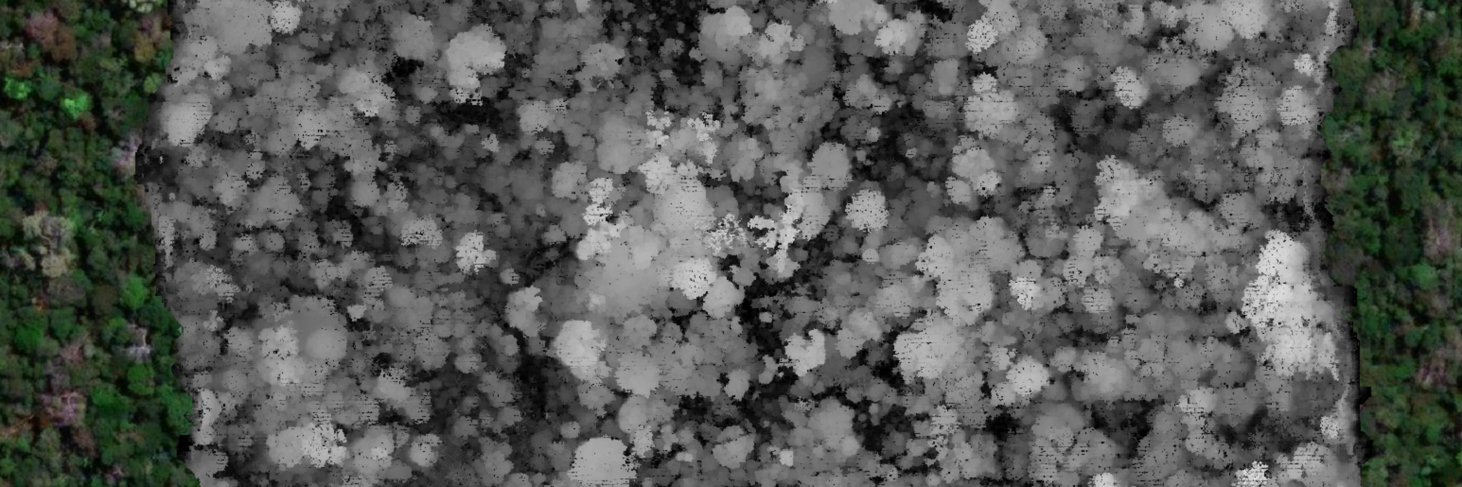
fazendo alguns testes pra mapear ganho de floresta (plantações ou regeneração natural) e comparando com bancos de dados existentes (GLAD TMF MapBiomas): pouca concordância 🤔
na imagem : preto=floresta estável, vermelho = nosso mapa de regeneração, azul = nosso + 1, verde = nosso + 2/3
na imagem : preto=floresta estável, vermelho = nosso mapa de regeneração, azul = nosso + 1, verde = nosso + 2/3


November 19, 2024 at 3:50 AM
fazendo alguns testes pra mapear ganho de floresta (plantações ou regeneração natural) e comparando com bancos de dados existentes (GLAD TMF MapBiomas): pouca concordância 🤔
na imagem : preto=floresta estável, vermelho = nosso mapa de regeneração, azul = nosso + 1, verde = nosso + 2/3
na imagem : preto=floresta estável, vermelho = nosso mapa de regeneração, azul = nosso + 1, verde = nosso + 2/3
Um rio-arvore e seus galhos protegendo os remanescentes de floresta contra o avanço do desmatamento pela plantação de palmeiras para oleo de palma na Malasia #SatArt
Image : Planet NICFI #NICFISatelliteDataProgram, mosaic Oct 2020 at 111.71116,2.67147 (lon,lat). (Celebrando 60 mosaicos !)
Image : Planet NICFI #NICFISatelliteDataProgram, mosaic Oct 2020 at 111.71116,2.67147 (lon,lat). (Celebrando 60 mosaicos !)

November 12, 2024 at 6:50 PM
Um rio-arvore e seus galhos protegendo os remanescentes de floresta contra o avanço do desmatamento pela plantação de palmeiras para oleo de palma na Malasia #SatArt
Image : Planet NICFI #NICFISatelliteDataProgram, mosaic Oct 2020 at 111.71116,2.67147 (lon,lat). (Celebrando 60 mosaicos !)
Image : Planet NICFI #NICFISatelliteDataProgram, mosaic Oct 2020 at 111.71116,2.67147 (lon,lat). (Celebrando 60 mosaicos !)
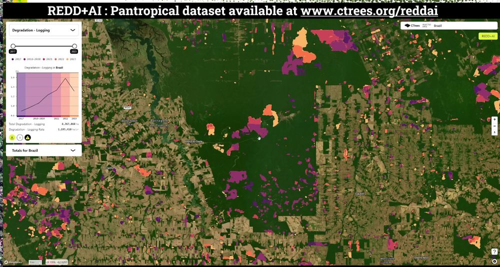
📢🛰️🌳Forest degradation & tree cover loss in the tropics can now be seen w/ high resolution & attributions based on #ArtificialIntelligence and Planet @NICFISatData 5m satellite data
Available for viz at REDD+AI platform: www.ctrees.org/reddai
@fabienwagner.bsky.social
Available for viz at REDD+AI platform: www.ctrees.org/reddai
@fabienwagner.bsky.social
October 22, 2024 at 9:23 PM
📢🛰️🌳Forest degradation & tree cover loss in the tropics can now be seen w/ high resolution & attributions based on #ArtificialIntelligence and Planet @NICFISatData 5m satellite data
Available for viz at REDD+AI platform: www.ctrees.org/reddai
@fabienwagner.bsky.social
Available for viz at REDD+AI platform: www.ctrees.org/reddai
@fabienwagner.bsky.social
🛰️🔥This diffusion model app is crazy - it edited the Planet NICFI satellite image changing some areas affected by deforestation, fire & logging to something else - mostly "reforested" them - and it actually looks good 📷
app: huggingface.co/spaces/OzzyG...
app: huggingface.co/spaces/OzzyG...

September 26, 2024 at 7:42 PM
🛰️🔥This diffusion model app is crazy - it edited the Planet NICFI satellite image changing some areas affected by deforestation, fire & logging to something else - mostly "reforested" them - and it actually looks good 📷
app: huggingface.co/spaces/OzzyG...
app: huggingface.co/spaces/OzzyG...
Trecho de Cochrane & Schulze (1998) sobre os incêndios na Amazônia durante o El Niño de 1997! 🌍🔥
Mais de 20 anos depois, o tema segue atual. As lições desses eventos ecoam até hoje - só não sei se são ouvidas. #Amazonia #MudançasClimáticas #Ciência
📚 Paper: www.jstor.org/stable/2387566
Mais de 20 anos depois, o tema segue atual. As lições desses eventos ecoam até hoje - só não sei se são ouvidas. #Amazonia #MudançasClimáticas #Ciência
📚 Paper: www.jstor.org/stable/2387566

September 26, 2024 at 7:04 PM
Trecho de Cochrane & Schulze (1998) sobre os incêndios na Amazônia durante o El Niño de 1997! 🌍🔥
Mais de 20 anos depois, o tema segue atual. As lições desses eventos ecoam até hoje - só não sei se são ouvidas. #Amazonia #MudançasClimáticas #Ciência
📚 Paper: www.jstor.org/stable/2387566
Mais de 20 anos depois, o tema segue atual. As lições desses eventos ecoam até hoje - só não sei se são ouvidas. #Amazonia #MudançasClimáticas #Ciência
📚 Paper: www.jstor.org/stable/2387566
Today I gave an online talk at #GISFOREST event in Brazil about my research & #CTrees forest monitoring systems that track selective #logging and #roads.
#CTrees new technology and data can help monitor forest management and illegal activities to enhance conservation and sustainable development.
#CTrees new technology and data can help monitor forest management and illegal activities to enhance conservation and sustainable development.

September 18, 2024 at 4:05 PM
Today I gave an online talk at #GISFOREST event in Brazil about my research & #CTrees forest monitoring systems that track selective #logging and #roads.
#CTrees new technology and data can help monitor forest management and illegal activities to enhance conservation and sustainable development.
#CTrees new technology and data can help monitor forest management and illegal activities to enhance conservation and sustainable development.
Os dados e tecnologias que estamos gerando com CTrees.org podem ser usados para monitorar o manejo de florestas nativas, bem como atividades ilegais que causam degradação de florestas públicas
Obrigado Ana Dalla Corte e #GISFOREST pelo convite! lignumlatinamerica.com/gis-forest/
Obrigado Ana Dalla Corte e #GISFOREST pelo convite! lignumlatinamerica.com/gis-forest/

September 17, 2024 at 7:44 PM
Os dados e tecnologias que estamos gerando com CTrees.org podem ser usados para monitorar o manejo de florestas nativas, bem como atividades ilegais que causam degradação de florestas públicas
Obrigado Ana Dalla Corte e #GISFOREST pelo convite! lignumlatinamerica.com/gis-forest/
Obrigado Ana Dalla Corte e #GISFOREST pelo convite! lignumlatinamerica.com/gis-forest/