


POW Ponder On Weather
@powponder.bsky.social
Your go-to source for all things weather. Protecting you before and after the storm.
The NWS has halted weather balloon launches from Kotzebue, AK, due to staffing shortages, impacting severe storm & hurricane forecasts.
Plus, hundreds of NWS employees were terminated today, further straining an already understaffed system.
Plus, hundreds of NWS employees were terminated today, further straining an already understaffed system.

February 28, 2025 at 4:39 AM
The NWS has halted weather balloon launches from Kotzebue, AK, due to staffing shortages, impacting severe storm & hurricane forecasts.
Plus, hundreds of NWS employees were terminated today, further straining an already understaffed system.
Plus, hundreds of NWS employees were terminated today, further straining an already understaffed system.
7:45pm Here comes the rain for the next 14 hours. Moving Northeast and training overnight. Rush hour commute will be a mess in the morning.

January 30, 2025 at 1:55 AM
7:45pm Here comes the rain for the next 14 hours. Moving Northeast and training overnight. Rush hour commute will be a mess in the morning.

🚨 HEAVY RAIN & SQUALL LINE ALERT NORTH TEXAS
• Wednesday: Scattered showers on/off.
• Wednesday Night: Rain intensifies with stronger storms.
⚡ Main Event – Early Thursday (5 AM)
• 🌩️ Frequent lightning
• 💨 Gusty winds
• 🧊 Small hail
• 🌊 Heavy downpours
🌤️ Rain Ends by 12pm
• 1-3” of rain
• Wednesday: Scattered showers on/off.
• Wednesday Night: Rain intensifies with stronger storms.
⚡ Main Event – Early Thursday (5 AM)
• 🌩️ Frequent lightning
• 💨 Gusty winds
• 🧊 Small hail
• 🌊 Heavy downpours
🌤️ Rain Ends by 12pm
• 1-3” of rain

January 28, 2025 at 8:31 PM
🚨 HEAVY RAIN & SQUALL LINE ALERT NORTH TEXAS
• Wednesday: Scattered showers on/off.
• Wednesday Night: Rain intensifies with stronger storms.
⚡ Main Event – Early Thursday (5 AM)
• 🌩️ Frequent lightning
• 💨 Gusty winds
• 🧊 Small hail
• 🌊 Heavy downpours
🌤️ Rain Ends by 12pm
• 1-3” of rain
• Wednesday: Scattered showers on/off.
• Wednesday Night: Rain intensifies with stronger storms.
⚡ Main Event – Early Thursday (5 AM)
• 🌩️ Frequent lightning
• 💨 Gusty winds
• 🧊 Small hail
• 🌊 Heavy downpours
🌤️ Rain Ends by 12pm
• 1-3” of rain
Galveston right now!

January 21, 2025 at 2:41 PM
Galveston right now!
BLIZZARD WARNING IN EFFECT UNTIL NOON CST TODAY
⚠️ What to Expect
• Blizzard conditions with reduced visibility and dangerous travel.
• Additional snow accumulations of 2 to 4 inches.
📍 Affected Areas
• Portions of south-central and southwest Louisiana.
• Portions of southeast Texas.

January 21, 2025 at 10:31 AM
BLIZZARD WARNING IN EFFECT UNTIL NOON CST TODAY
⚠️ What to Expect
• Blizzard conditions with reduced visibility and dangerous travel.
• Additional snow accumulations of 2 to 4 inches.
📍 Affected Areas
• Portions of south-central and southwest Louisiana.
• Portions of southeast Texas.

Houston Winter Storm Watch
Rare Winter Storm Watch just issued for #Houston Monday evening to Tuesday afternoon.
Snow ❄️ amounts up to 3 inches in the metroplex along with 1/10 inch ice.
Last snow was February 15th 2021 in Houston it snowed one inch.
Rare Winter Storm Watch just issued for #Houston Monday evening to Tuesday afternoon.
Snow ❄️ amounts up to 3 inches in the metroplex along with 1/10 inch ice.
Last snow was February 15th 2021 in Houston it snowed one inch.

January 18, 2025 at 10:00 PM
Houston Winter Storm Watch
Rare Winter Storm Watch just issued for #Houston Monday evening to Tuesday afternoon.
Snow ❄️ amounts up to 3 inches in the metroplex along with 1/10 inch ice.
Last snow was February 15th 2021 in Houston it snowed one inch.
Rare Winter Storm Watch just issued for #Houston Monday evening to Tuesday afternoon.
Snow ❄️ amounts up to 3 inches in the metroplex along with 1/10 inch ice.
Last snow was February 15th 2021 in Houston it snowed one inch.
This is Wild! By Tuesday All 50 States Could Have Snow ❄️ On The Ground. 🥶🪵
January 17, 2025 at 11:58 PM
This is Wild! By Tuesday All 50 States Could Have Snow ❄️ On The Ground. 🥶🪵
An Arctic airmass takes over the lower 48 early next week. Fairly rare to see the entire state of #Texas below freezing. Average low of 6 degrees for the Us. It would be the worst outbreak since January 2014.
It will be warmer in parts of Alaska and even the West coast of Greenland than Texas.

January 15, 2025 at 3:12 PM
An Arctic airmass takes over the lower 48 early next week. Fairly rare to see the entire state of #Texas below freezing. Average low of 6 degrees for the Us. It would be the worst outbreak since January 2014.
It will be warmer in parts of Alaska and even the West coast of Greenland than Texas.

Additional snow tonight in North Texas.

January 10, 2025 at 1:14 AM
Additional snow tonight in North Texas.
SNOWFALL % OVER 1 INCH ❄️❄️
The latest EPS Euro Ensembles now have an 80% probability for North Texas seeing at least one inch of snow Thursday and Friday.
The latest EPS Euro Ensembles now have an 80% probability for North Texas seeing at least one inch of snow Thursday and Friday.
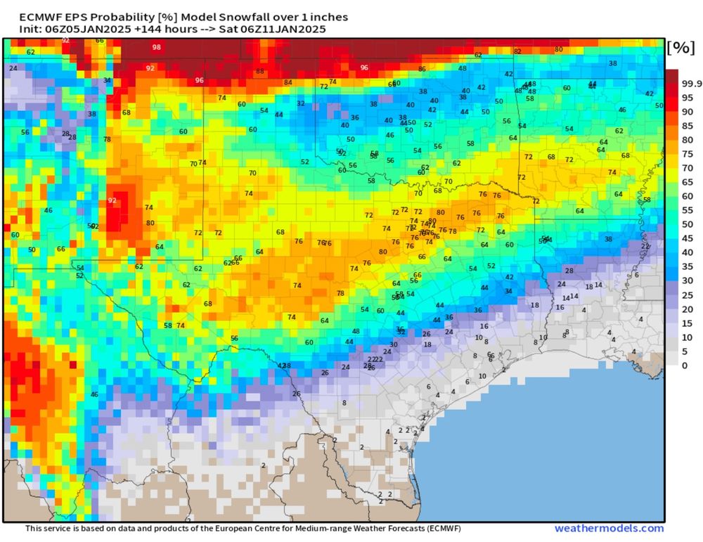
January 5, 2025 at 4:55 PM
SNOWFALL % OVER 1 INCH ❄️❄️
The latest EPS Euro Ensembles now have an 80% probability for North Texas seeing at least one inch of snow Thursday and Friday.
The latest EPS Euro Ensembles now have an 80% probability for North Texas seeing at least one inch of snow Thursday and Friday.
January is already the coldest month of the year. Now you add this for the 2nd week of January.

December 31, 2024 at 3:08 AM
January is already the coldest month of the year. Now you add this for the 2nd week of January.
HEADS UP 🥶 POLAR VORTEX…
Longer range signals are pointing at a stratospheric warming event developing between Dec 22nd to Dec 29th timeframe. This could mean very cold air into the lower 48 for January depending on how the oscillations line up. Stay tuned for updates.
Longer range signals are pointing at a stratospheric warming event developing between Dec 22nd to Dec 29th timeframe. This could mean very cold air into the lower 48 for January depending on how the oscillations line up. Stay tuned for updates.

December 11, 2024 at 1:12 AM
HEADS UP 🥶 POLAR VORTEX…
Longer range signals are pointing at a stratospheric warming event developing between Dec 22nd to Dec 29th timeframe. This could mean very cold air into the lower 48 for January depending on how the oscillations line up. Stay tuned for updates.
Longer range signals are pointing at a stratospheric warming event developing between Dec 22nd to Dec 29th timeframe. This could mean very cold air into the lower 48 for January depending on how the oscillations line up. Stay tuned for updates.
Here is how November ended up over last 30 days.

December 1, 2024 at 4:16 AM
Here is how November ended up over last 30 days.
Insane lake effect snow. NWS now forecasting 81 inches in Watertown, NY.
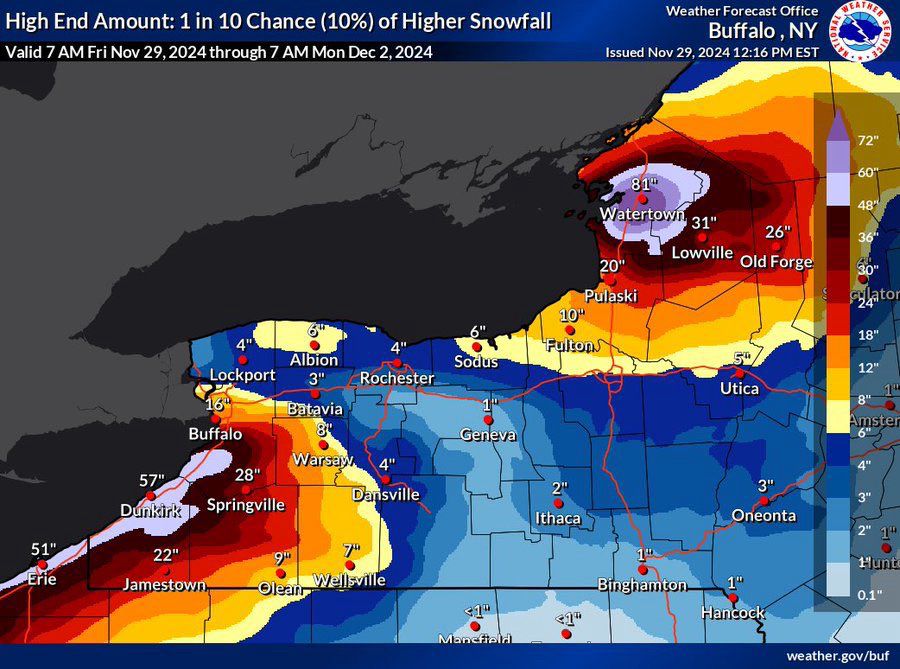
November 29, 2024 at 10:38 PM
Insane lake effect snow. NWS now forecasting 81 inches in Watertown, NY.
76% of the lower 48 sees a freeze Friday morning.

November 28, 2024 at 8:40 PM
76% of the lower 48 sees a freeze Friday morning.
You can see the cold front moving into Dallas this morning.
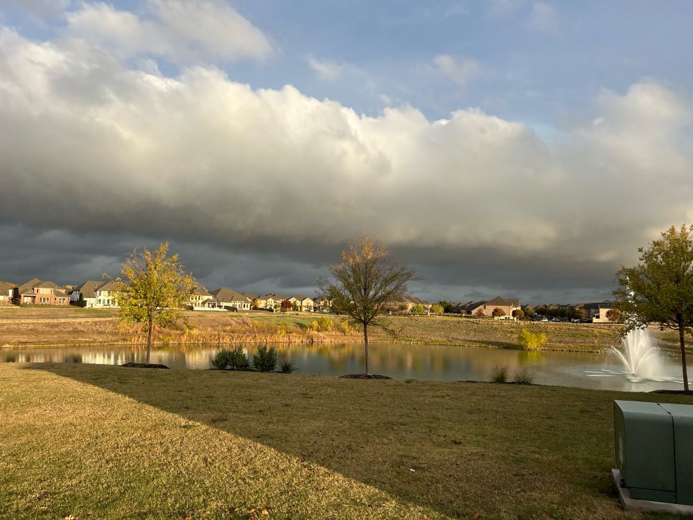
November 25, 2024 at 2:05 PM
You can see the cold front moving into Dallas this morning.
BLACK FRIDAY SHOPPING WIND CHILLS! 🥶

November 25, 2024 at 1:50 AM
BLACK FRIDAY SHOPPING WIND CHILLS! 🥶
Coldest Airmass of the season!!
Cross polar flow will set up after Thanksgiving with the coldest airmass of the season. The core of the coldest anomalies will be over the Ohio Valley into the Mid Atlantic. The Southeast will see its first hard freeze of the season to start #December.
Cross polar flow will set up after Thanksgiving with the coldest airmass of the season. The core of the coldest anomalies will be over the Ohio Valley into the Mid Atlantic. The Southeast will see its first hard freeze of the season to start #December.

November 24, 2024 at 9:13 PM
Coldest Airmass of the season!!
Cross polar flow will set up after Thanksgiving with the coldest airmass of the season. The core of the coldest anomalies will be over the Ohio Valley into the Mid Atlantic. The Southeast will see its first hard freeze of the season to start #December.
Cross polar flow will set up after Thanksgiving with the coldest airmass of the season. The core of the coldest anomalies will be over the Ohio Valley into the Mid Atlantic. The Southeast will see its first hard freeze of the season to start #December.
Coldest Air Mass of the Season Incoming
A significant Arctic air mass is poised to plunge into the United States late next week, delivering the coldest temperatures of the season. The core of this colder air heading into December will track eastward, impacting the Ohio Valley and the Mid-Atlantic.
A significant Arctic air mass is poised to plunge into the United States late next week, delivering the coldest temperatures of the season. The core of this colder air heading into December will track eastward, impacting the Ohio Valley and the Mid-Atlantic.

November 23, 2024 at 9:32 PM
Coldest Air Mass of the Season Incoming
A significant Arctic air mass is poised to plunge into the United States late next week, delivering the coldest temperatures of the season. The core of this colder air heading into December will track eastward, impacting the Ohio Valley and the Mid-Atlantic.
A significant Arctic air mass is poised to plunge into the United States late next week, delivering the coldest temperatures of the season. The core of this colder air heading into December will track eastward, impacting the Ohio Valley and the Mid-Atlantic.
Cold Thanksgiving & Black Friday Coming Up.

November 23, 2024 at 12:20 AM
Cold Thanksgiving & Black Friday Coming Up.
The season’s first snowfall is set to hit the central and northern Appalachians later today through Friday, with higher elevations seeing the most accumulation and lower areas in Pennsylvania and New York also expecting some snow.

November 21, 2024 at 10:55 AM
The season’s first snowfall is set to hit the central and northern Appalachians later today through Friday, with higher elevations seeing the most accumulation and lower areas in Pennsylvania and New York also expecting some snow.
Bomb Cyclone 🌀
An intense “bomb cyclone” will merge with an atmospheric river, bringing torrential rain exceeding a month’s average, hurricane-force winds, and several feet of mountain snow to the Pacific Northwest and Northern California.
An intense “bomb cyclone” will merge with an atmospheric river, bringing torrential rain exceeding a month’s average, hurricane-force winds, and several feet of mountain snow to the Pacific Northwest and Northern California.

November 20, 2024 at 4:22 AM
Bomb Cyclone 🌀
An intense “bomb cyclone” will merge with an atmospheric river, bringing torrential rain exceeding a month’s average, hurricane-force winds, and several feet of mountain snow to the Pacific Northwest and Northern California.
An intense “bomb cyclone” will merge with an atmospheric river, bringing torrential rain exceeding a month’s average, hurricane-force winds, and several feet of mountain snow to the Pacific Northwest and Northern California.