


Preston Bradley
@pj93wx.bsky.social
🌪Meteorologist|Storm Chaser|Photographer🌪
link: https://www.tumblr.com/chasingplainandsmiple
Disclaimer: Opinions are my own
link: https://www.tumblr.com/chasingplainandsmiple
Disclaimer: Opinions are my own


@memphisweather.net in Bartlett, TN pic of a shelf cloud or at least part of it.


June 7, 2025 at 2:40 PM
@memphisweather.net in Bartlett, TN pic of a shelf cloud or at least part of it.
Smoke from the Canadian Wildfires will be, if not already is, impacting portions of the US over the next few days thanks to northwesterly flow in the mid-levels of the atmosphere. Will make for some great sunset pics and might bring hazy conditions as well.
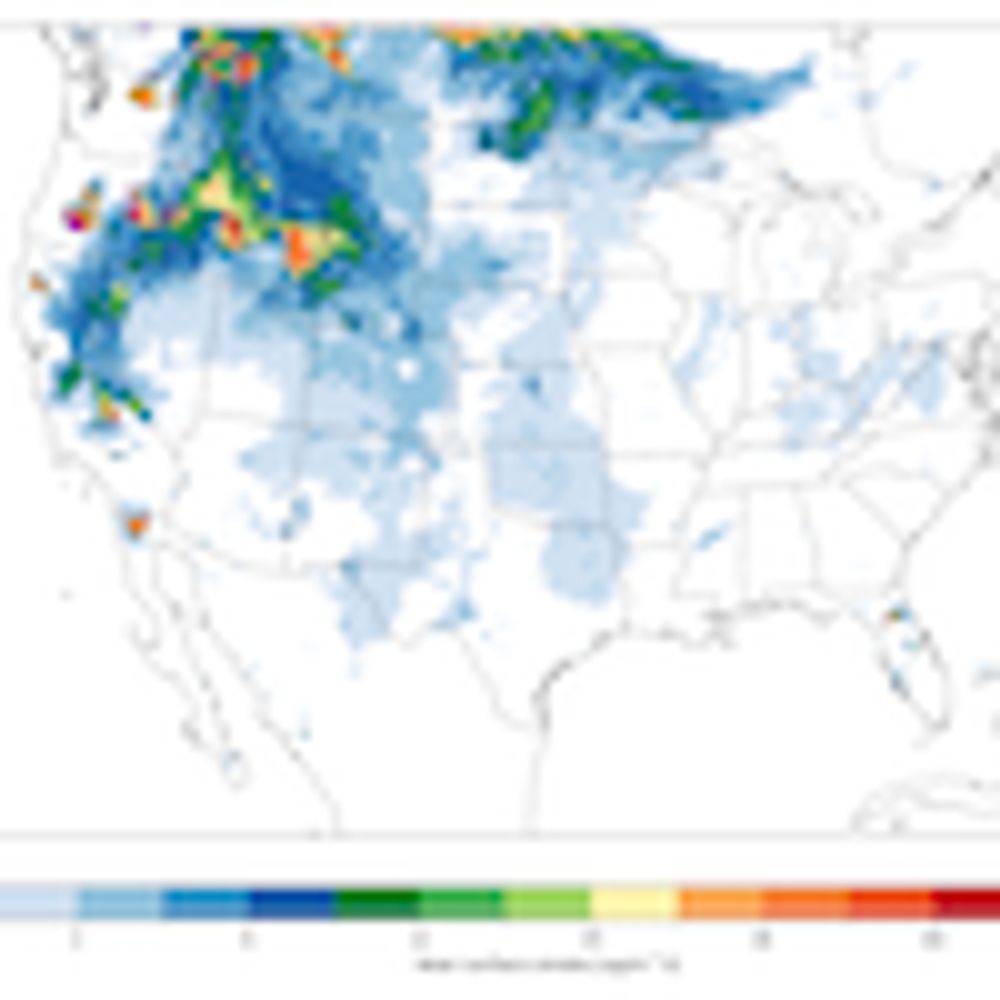
Near surface smoke forecast for the CONUS area.
Model run: 20250531T22:00 UTC
Data from NOAA's HRRR CONUS (https://rapidrefresh.noaa.gov/hrrr/)
Note that this product comes with absolutely no guarantee of availability, accuracy or completeness.
#Wildfires #Smoke #Manitoba #AirQuality
Model run: 20250531T22:00 UTC
Data from NOAA's HRRR CONUS (https://rapidrefresh.noaa.gov/hrrr/)
Note that this product comes with absolutely no guarantee of availability, accuracy or completeness.
#Wildfires #Smoke #Manitoba #AirQuality
June 1, 2025 at 2:01 AM
Smoke from the Canadian Wildfires will be, if not already is, impacting portions of the US over the next few days thanks to northwesterly flow in the mid-levels of the atmosphere. Will make for some great sunset pics and might bring hazy conditions as well.
Reposted by Preston Bradley
Good morning from Ponca City, OK. Plan is to play southwestern/southcentral KS, which may have the best combo of lift and spatial extent of instability. We will be departing for Medicine Lodge, KS shortly and adjust from there.
May 18, 2025 at 3:04 PM
Good morning from Ponca City, OK. Plan is to play southwestern/southcentral KS, which may have the best combo of lift and spatial extent of instability. We will be departing for Medicine Lodge, KS shortly and adjust from there.

Link: www.facebook.com/profile.php?...
If you want to see more photos like this, come check out my storm chasing page on Facebook. After some thinking, will use Facebook to upload my photographs from now on out. Will also continue to share a couple of photos on here as well like the one👇.
If you want to see more photos like this, come check out my storm chasing page on Facebook. After some thinking, will use Facebook to upload my photographs from now on out. Will also continue to share a couple of photos on here as well like the one👇.

April 1, 2025 at 1:33 AM
Link: www.facebook.com/profile.php?...
If you want to see more photos like this, come check out my storm chasing page on Facebook. After some thinking, will use Facebook to upload my photographs from now on out. Will also continue to share a couple of photos on here as well like the one👇.
If you want to see more photos like this, come check out my storm chasing page on Facebook. After some thinking, will use Facebook to upload my photographs from now on out. Will also continue to share a couple of photos on here as well like the one👇.

I have decided that I will be chasing this afternoon/evening as it will be a decent chance for discrete storms across Northeast AR/MO Bootheel before the storms merge into a linear system. The severe weather threat will also continue into the overnight hours as well. Take all warnings seriously.

March 30, 2025 at 3:02 PM
I have decided that I will be chasing this afternoon/evening as it will be a decent chance for discrete storms across Northeast AR/MO Bootheel before the storms merge into a linear system. The severe weather threat will also continue into the overnight hours as well. Take all warnings seriously.
A Severe Thunderstorm Watch has been issued for Central MS and northern AL until midnight tonight. A watch means conditions are favorable for storm to become severe.

March 23, 2025 at 10:14 PM
A Severe Thunderstorm Watch has been issued for Central MS and northern AL until midnight tonight. A watch means conditions are favorable for storm to become severe.
A Tornado Watch has been issued for West TN, North MS, eastern AR, Southwest KY and portions of Middle TN until 11 PM.
A watch means conditions are favorable for tornadoes.
A watch means conditions are favorable for tornadoes.

March 23, 2025 at 8:19 PM
A Tornado Watch has been issued for West TN, North MS, eastern AR, Southwest KY and portions of Middle TN until 11 PM.
A watch means conditions are favorable for tornadoes.
A watch means conditions are favorable for tornadoes.
SPC has increased their confidence for the potential tornadic storms this afternoon/evening for MS and TN. However, I am unlikely to chase today as model guidance showing the best chance for discrete storms being to my north. Will make an attempt to get lightning photos this evening, if possible.


March 23, 2025 at 2:33 PM
SPC has increased their confidence for the potential tornadic storms this afternoon/evening for MS and TN. However, I am unlikely to chase today as model guidance showing the best chance for discrete storms being to my north. Will make an attempt to get lightning photos this evening, if possible.
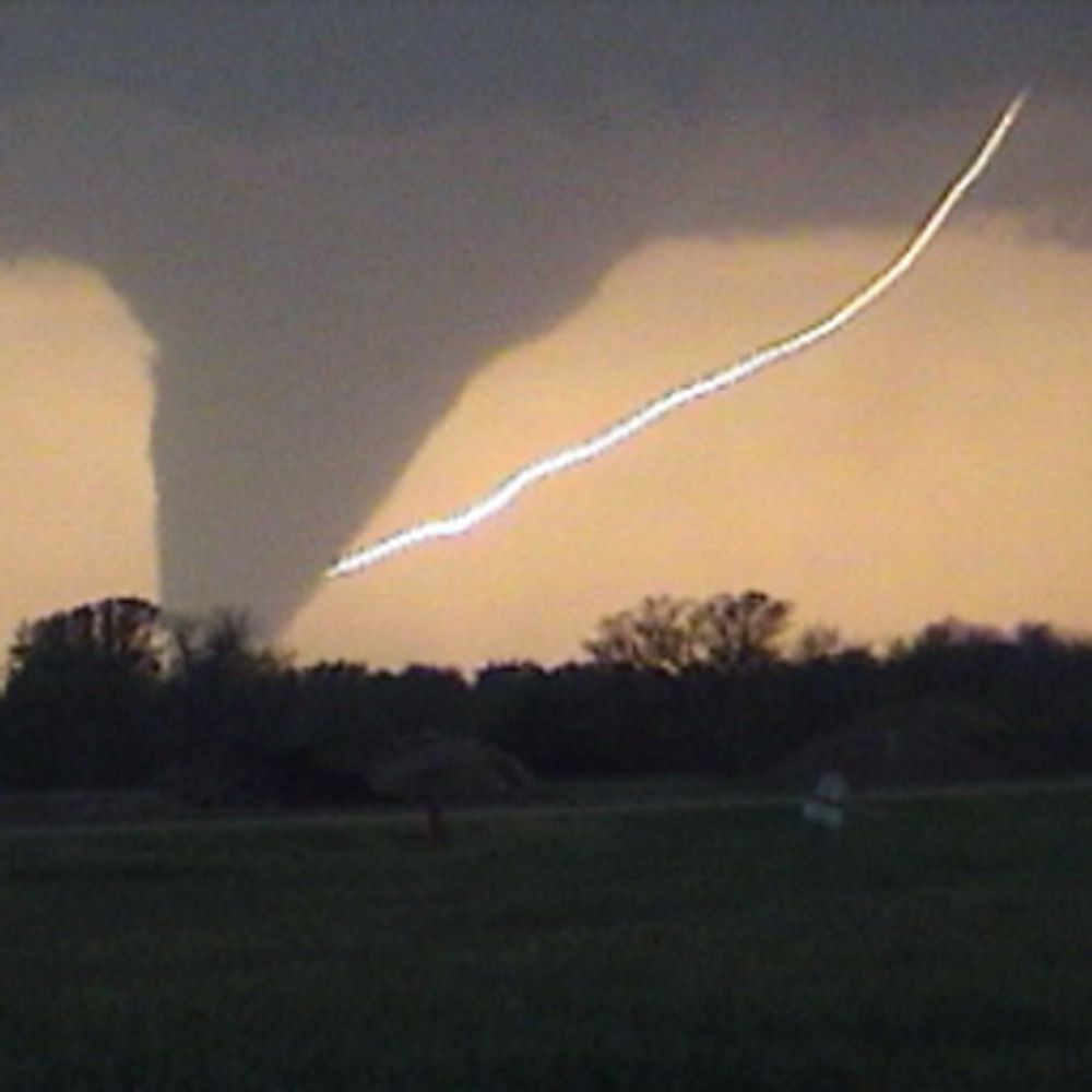
While I was unable to chase any tornadoes yesterday, I did channel in my inner wildlife photography for the first time and capture this gem while being on the reservoir.

March 16, 2025 at 7:58 PM
While I was unable to chase any tornadoes yesterday, I did channel in my inner wildlife photography for the first time and capture this gem while being on the reservoir.
Latest MD regarding the issuance of a PDS Tornado Watch for Centra and NE MS. Today is just getting started. Take all warnings and watches seriously. There will be potential for long track and violent tornadoes across the region.

March 15, 2025 at 3:18 PM
Latest MD regarding the issuance of a PDS Tornado Watch for Centra and NE MS. Today is just getting started. Take all warnings and watches seriously. There will be potential for long track and violent tornadoes across the region.
Never a good sign when 12z sounding already showing 1,000 plus CAPE for both sfc and ML. High risk as been extended into north AL. All modes of severe weather likely along with long track and violent tornadoes will be possible.


March 15, 2025 at 1:24 PM
Never a good sign when 12z sounding already showing 1,000 plus CAPE for both sfc and ML. High risk as been extended into north AL. All modes of severe weather likely along with long track and violent tornadoes will be possible.
Will not be chasing today as the overall environment is not favorable for chasing. However, the severe weather threat remains present with the major concerns being damaging winds and tornadoes.


March 4, 2025 at 3:13 PM
Will not be chasing today as the overall environment is not favorable for chasing. However, the severe weather threat remains present with the major concerns being damaging winds and tornadoes.
Not every day you get a Red Flag Warning across North MS. More information can be found in the graphic 👇

March 1, 2025 at 7:01 PM
Not every day you get a Red Flag Warning across North MS. More information can be found in the graphic 👇
Who’s needs to chase and when comes straight for you 😅🙃🙃🙃

February 16, 2025 at 12:07 AM
Who’s needs to chase and when comes straight for you 😅🙃🙃🙃
Tornado Watch has been issued which extends from Central Louisiana all the way up to western TN until 10 PM tonight. Remember a watch just means conditions are favorable for a tornado.

February 15, 2025 at 10:01 PM
Tornado Watch has been issued which extends from Central Louisiana all the way up to western TN until 10 PM tonight. Remember a watch just means conditions are favorable for a tornado.
Today I have decided to not chase due to the main tornado threat being associated with the QLCS along with the low potential of discrete storms out ahead of the QLCS.

February 15, 2025 at 2:31 PM
Today I have decided to not chase due to the main tornado threat being associated with the QLCS along with the low potential of discrete storms out ahead of the QLCS.
Given the current model guidance, tomorrow does not look good for chasing at all. It appears the main show will be embedded within the line and will be towards the evening hours. Will continue to monitor model data to see if any prefrontal storms could develop before making a final decision.


February 15, 2025 at 12:25 AM
Given the current model guidance, tomorrow does not look good for chasing at all. It appears the main show will be embedded within the line and will be towards the evening hours. Will continue to monitor model data to see if any prefrontal storms could develop before making a final decision.
While at work yesterday, I saw plume of dust being transported across AR into North MS and West TN behind a front. I find it cool to share with everyone. This should serve as a reminder how important something like satellites are to meteorologists when tracking weather phenomena.
February 2, 2025 at 1:54 AM
While at work yesterday, I saw plume of dust being transported across AR into North MS and West TN behind a front. I find it cool to share with everyone. This should serve as a reminder how important something like satellites are to meteorologists when tracking weather phenomena.
As a reminder, parts of Central and South MS will be experiencing a rare winter storm with significant snowfall accumulations from tonight into tomorrow. While not everyone will see snow, there is the extreme cold temps that will impact much of the region. Details in the graphics 👇 #mswx


January 21, 2025 at 2:08 AM
As a reminder, parts of Central and South MS will be experiencing a rare winter storm with significant snowfall accumulations from tonight into tomorrow. While not everyone will see snow, there is the extreme cold temps that will impact much of the region. Details in the graphics 👇 #mswx
Those in Central MS and South MS, get prepared for a rare winter storm across the region. Not everyone will see snowfall, but will experience extremely cold conditions this week. See graphics for more details on timing and impacts. #mswx


January 20, 2025 at 2:40 AM
Those in Central MS and South MS, get prepared for a rare winter storm across the region. Not everyone will see snowfall, but will experience extremely cold conditions this week. See graphics for more details on timing and impacts. #mswx
Winter Storm Warning in effect for all of the areas in pink. Wintry precip expected to begin Thurs. evening and will last into Fri. afternoon. Snowfall totals will range from 4" to 6" with some areas seeing more or less pending location across AR, northern MS and West TN. Main


January 9, 2025 at 2:21 AM
Winter Storm Warning in effect for all of the areas in pink. Wintry precip expected to begin Thurs. evening and will last into Fri. afternoon. Snowfall totals will range from 4" to 6" with some areas seeing more or less pending location across AR, northern MS and West TN. Main
For those up in North MS, AR & West TN should be getting prepared for a significant winter storm for Thursday into Friday. This is not a matter who gets snow, but how much. Widespread of 4 to 6 inches of snow should be expected. Some areas could see more or less pending snow bands and location.


January 8, 2025 at 1:03 AM
For those up in North MS, AR & West TN should be getting prepared for a significant winter storm for Thursday into Friday. This is not a matter who gets snow, but how much. Widespread of 4 to 6 inches of snow should be expected. Some areas could see more or less pending snow bands and location.