


NWS Pittsburgh (Unofficial Mirror)
@nwspittsburgh.bsky.social
Unofficial mirror of the National Weather Service Pittsburgh X Feed (@NWSPittsburgh).
Not affiliated with NOAA/NWS.
Comments are not monitored, and posts may not be timely.
Visit weather.gov/pbz for official information.
Not affiliated with NOAA/NWS.
Comments are not monitored, and posts may not be timely.
Visit weather.gov/pbz for official information.
Pinned
Sorry folks. Twitter/X broke the ability for me to automatically scrape and mirror content here. There aren't currently any good alternative methods, so this profile will not be update unless something changes.
Sorry folks. Twitter/X broke the ability for me to automatically scrape and mirror content here. There aren't currently any good alternative methods, so this profile will not be update unless something changes.
January 15, 2026 at 9:13 AM
Sorry folks. Twitter/X broke the ability for me to automatically scrape and mirror content here. There aren't currently any good alternative methods, so this profile will not be update unless something changes.
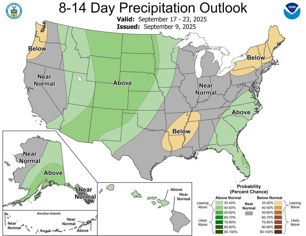
In the September 17th to 23rd outlook, the below normal precipitation outlook has been pulled north signaling a push of moisture into the SW PA region. During this period, Sept 20th and 21st have a decent chance for a 0.10 or more of precipitation.

September 10, 2025 at 2:25 PM
In the September 17th to 23rd outlook, the below normal precipitation outlook has been pulled north signaling a push of moisture into the SW PA region. During this period, Sept 20th and 21st have a decent chance for a 0.10 or more of precipitation.
Dry conditions and mostly sunny skies continue today with temperatures still trending up. Highs will end up right around normal this afternoon.

September 10, 2025 at 9:40 AM
Dry conditions and mostly sunny skies continue today with temperatures still trending up. Highs will end up right around normal this afternoon.
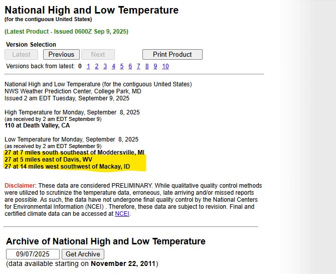
So....Canaan Valley ended up "winning" for lowest temperature in the CONUS on the 9th.

September 10, 2025 at 4:35 AM
So....Canaan Valley ended up "winning" for lowest temperature in the CONUS on the 9th.
Meteorologists use a different accounting of the seasons than the astronomical cycle, by starting the season at the beginning of a month. This aligns with the yearly temp cycle while also keeping records consistent - astronomical season start dates can vary from year to year.

September 9, 2025 at 11:55 PM
Meteorologists use a different accounting of the seasons than the astronomical cycle, by starting the season at the beginning of a month. This aligns with the yearly temp cycle while also keeping records consistent - astronomical season start dates can vary from year to year.
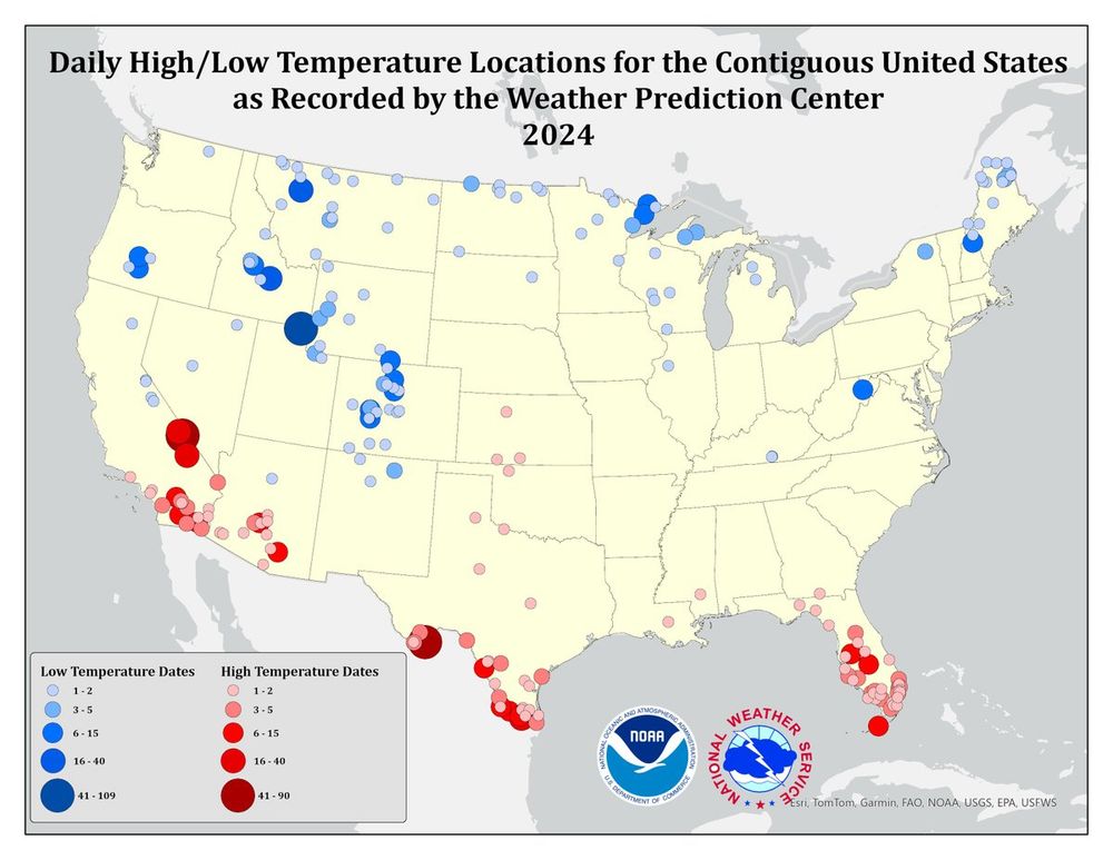
Here are locations where national high/low temps were observed in 2023 and 2024 (larger circle = greater number of occurrences).
Canaan Valley, WV gets the award for lowest national temp a few times a year, mostly in the spring and fall on clear and calm nights like these.
Canaan Valley, WV gets the award for lowest national temp a few times a year, mostly in the spring and fall on clear and calm nights like these.

September 9, 2025 at 5:40 PM
Here are locations where national high/low temps were observed in 2023 and 2024 (larger circle = greater number of occurrences).
Canaan Valley, WV gets the award for lowest national temp a few times a year, mostly in the spring and fall on clear and calm nights like these.
Canaan Valley, WV gets the award for lowest national temp a few times a year, mostly in the spring and fall on clear and calm nights like these.
Canaan Valley tied for coldest observation site yesterday morning, and it looks like they may have a chance at being the coldest in the US today seeing that they are currently sitting at 23F this morning.

September 9, 2025 at 9:25 AM
Canaan Valley tied for coldest observation site yesterday morning, and it looks like they may have a chance at being the coldest in the US today seeing that they are currently sitting at 23F this morning.
Piggybacking on a recent post, here is a comparison of hourly temperature departures from normal back to 1973 at Pittsburgh International Airport. The one on the left is the hourly temperature departure from normal with clear skies, and on the right, mostly cloudy conditions.

September 9, 2025 at 7:05 AM
Piggybacking on a recent post, here is a comparison of hourly temperature departures from normal back to 1973 at Pittsburgh International Airport. The one on the left is the hourly temperature departure from normal with clear skies, and on the right, mostly cloudy conditions.
If you're not enjoying the cooler weather, you'll be pleased to know that a pattern shift is anticipated at the end of the week, bringing near to above-average temperatures back for the weekend.

September 8, 2025 at 11:25 PM
If you're not enjoying the cooler weather, you'll be pleased to know that a pattern shift is anticipated at the end of the week, bringing near to above-average temperatures back for the weekend.
A daily record low was set at DuBois, PA today at 37°F degrees. This breaks the old record low of 38°F set in 1986.
September 8, 2025 at 9:35 PM
A daily record low was set at DuBois, PA today at 37°F degrees. This breaks the old record low of 38°F set in 1986.
Wildfire safety refresher! Many everyday things can spark wildfires. Keep ignition sources far away from dry vegetation, wood and other fuel. Be aware of weather conditions. Always follow burn bans & local, state, and federal regulations. http://weather.gov/safety/wildfire-ww #WeatherReady

September 8, 2025 at 5:30 PM
Wildfire safety refresher! Many everyday things can spark wildfires. Keep ignition sources far away from dry vegetation, wood and other fuel. Be aware of weather conditions. Always follow burn bans & local, state, and federal regulations. http://weather.gov/safety/wildfire-ww #WeatherReady
Most of us have seen 25-50% of our normal precipitation in the past 30 days and there's no rain in the forecast for at least the rest of this week. During a drought, stay Weather-Ready by conserving water and practicing fire prevention. http://weather.gov/safety/drought


September 8, 2025 at 5:25 PM
Most of us have seen 25-50% of our normal precipitation in the past 30 days and there's no rain in the forecast for at least the rest of this week. During a drought, stay Weather-Ready by conserving water and practicing fire prevention. http://weather.gov/safety/drought
Dry conditions and a gradual warming trend (can be expected over the coming week, with large diurnal variations (~90th percentile) in low/high temperatures as minimal cloud coverage allows for efficient overnight cooling.

September 8, 2025 at 8:45 AM
Dry conditions and a gradual warming trend (can be expected over the coming week, with large diurnal variations (~90th percentile) in low/high temperatures as minimal cloud coverage allows for efficient overnight cooling.
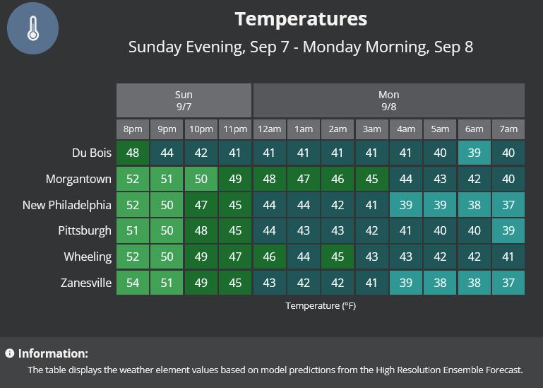
With clear skies and cool upper air, a chilly Monday morning is anticipated.
September 7, 2025 at 11:10 PM
With clear skies and cool upper air, a chilly Monday morning is anticipated.
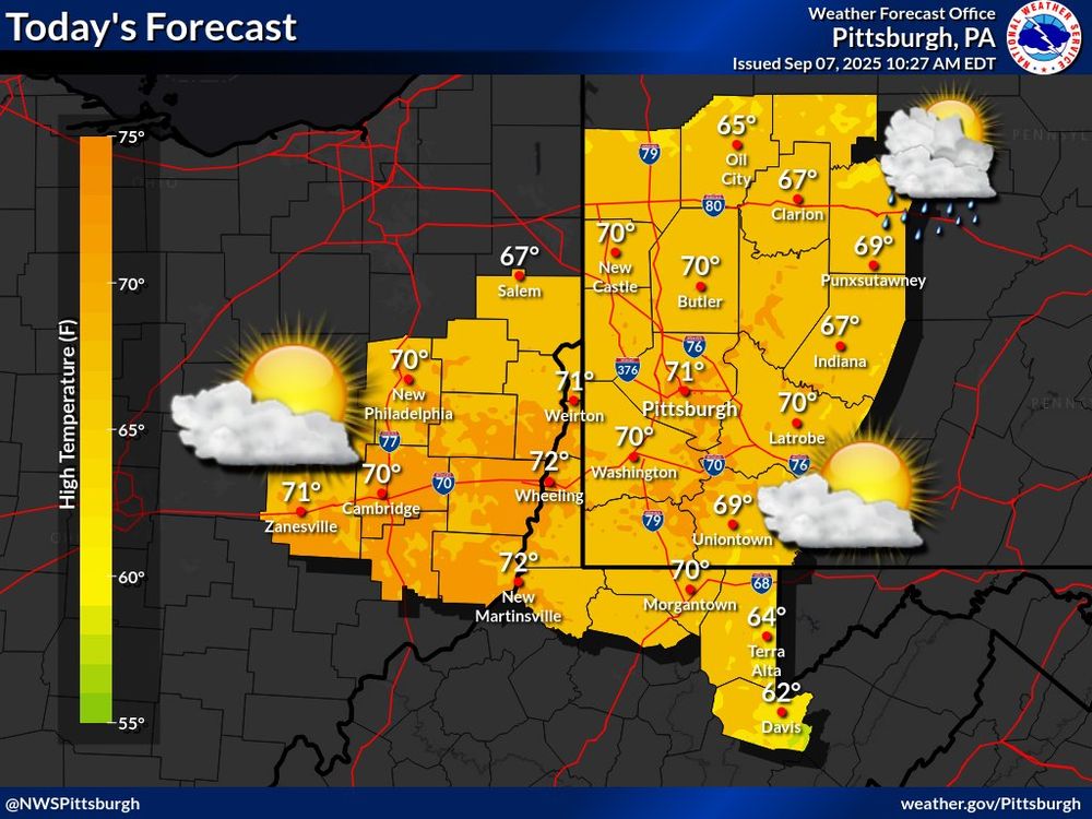
It will be a beautiful day for most today under partly cloudy skies with highs around 10 degrees below normal. Chances of scattered showers only linger for the I-80 corridor.
September 7, 2025 at 2:35 PM
It will be a beautiful day for most today under partly cloudy skies with highs around 10 degrees below normal. Chances of scattered showers only linger for the I-80 corridor.
Dry conditions and a gradual warming trend (from 10 degrees below normal to normal/slightly above normal) can be expected over the coming week.

September 7, 2025 at 7:55 AM
Dry conditions and a gradual warming trend (from 10 degrees below normal to normal/slightly above normal) can be expected over the coming week.
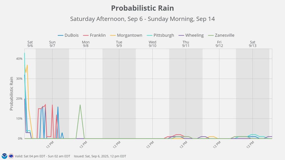
There's a low chance of rain over the next few day, with a slight possibility of lake-enhanced precipitation tomorrow for areas north of Pittsburgh. Temperatures are expected to be cool tonight and tomorrow, then warm up through the week.


September 7, 2025 at 12:55 AM
There's a low chance of rain over the next few day, with a slight possibility of lake-enhanced precipitation tomorrow for areas north of Pittsburgh. Temperatures are expected to be cool tonight and tomorrow, then warm up through the week.
Westerly dry air is helping to clear the thick cloud cover, and sunshine is already breaking through in parts of eastern Ohio.
September 6, 2025 at 10:00 PM
Westerly dry air is helping to clear the thick cloud cover, and sunshine is already breaking through in parts of eastern Ohio.
After today (tomorrow for the I-80 corridor), hopes look pretty grim for rain over the next week with high pressure in place. Do you like dry fall weather or do you prefer the rain?
September 6, 2025 at 4:40 PM
After today (tomorrow for the I-80 corridor), hopes look pretty grim for rain over the next week with high pressure in place. Do you like dry fall weather or do you prefer the rain?
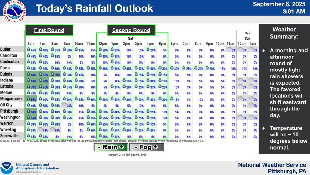
Two rounds of showers (one in the morning and one in the afternoon) will bring mostly light rain to the area today. The 1st wave will favor areas east of the OH/WV border; the 2nd will favor cities SE of Pittsburgh. Temperature today will be ~10 degrees below the daily average.
September 6, 2025 at 7:35 AM
Two rounds of showers (one in the morning and one in the afternoon) will bring mostly light rain to the area today. The 1st wave will favor areas east of the OH/WV border; the 2nd will favor cities SE of Pittsburgh. Temperature today will be ~10 degrees below the daily average.
Isolated storms are starting to fire up ahead of the cold front that stretches down into West Virginia and Kentucky. The best opportunity for strong to severe storms in our area will be over the next 4 hours.
September 5, 2025 at 9:30 PM
Isolated storms are starting to fire up ahead of the cold front that stretches down into West Virginia and Kentucky. The best opportunity for strong to severe storms in our area will be over the next 4 hours.
Showers and possible thunderstorms are expected tonight into part of Saturday with a crossing cold front.
September 5, 2025 at 5:05 PM
Showers and possible thunderstorms are expected tonight into part of Saturday with a crossing cold front.
Partly cloudy skies and warmer temperatures are expected today.

September 5, 2025 at 2:00 PM
Partly cloudy skies and warmer temperatures are expected today.
Areas of fog have developed across the region, with a Dense Fog Advisory in effect until 9am for portions of western PA. If you are out driving, exercise caution as visibilities could be reduced to less than 1/4 mile.
Visit your state's DOT site for the latest road conditions.
Visit your state's DOT site for the latest road conditions.

September 5, 2025 at 5:35 AM
Areas of fog have developed across the region, with a Dense Fog Advisory in effect until 9am for portions of western PA. If you are out driving, exercise caution as visibilities could be reduced to less than 1/4 mile.
Visit your state's DOT site for the latest road conditions.
Visit your state's DOT site for the latest road conditions.
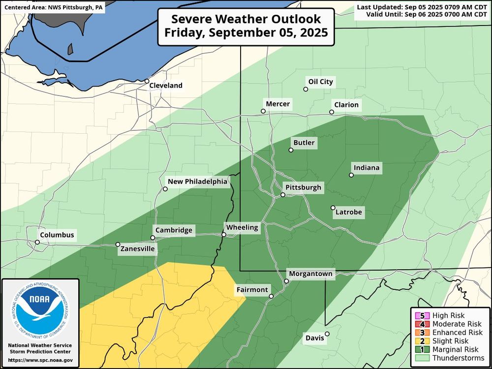
There is another day with the potential for severe weather on Friday. The main threat will be damaging winds. The timing will feature storms entering the forecast area by 7-8pm and crossing the Pittsburgh area by 9pm-10pm.
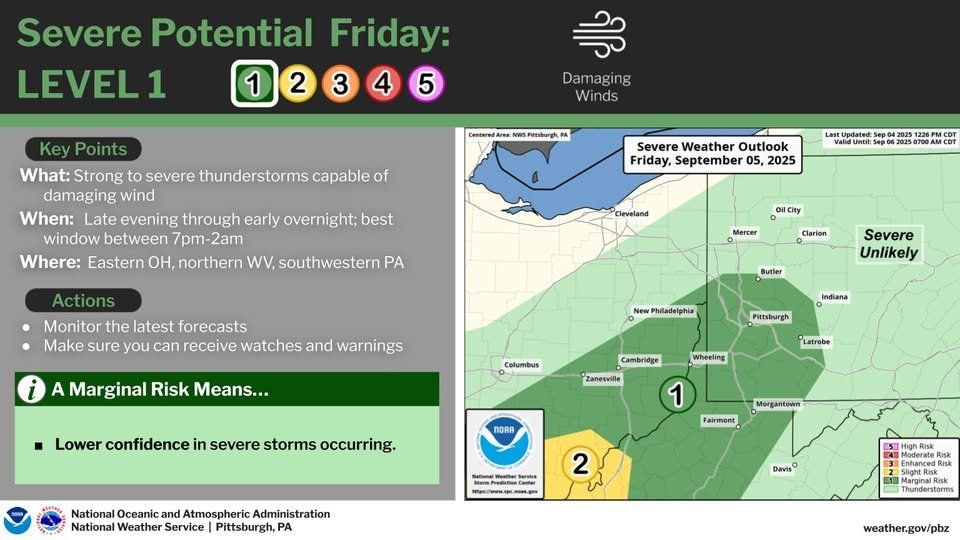
September 4, 2025 at 11:40 PM
There is another day with the potential for severe weather on Friday. The main threat will be damaging winds. The timing will feature storms entering the forecast area by 7-8pm and crossing the Pittsburgh area by 9pm-10pm.